Katyuri kings

Last updated

Karttikeyapur (Katyur) Kingdom
Kurmanchal
700 CE–1065 CE
Status Sovereign state
Capital Joshimath later shifted to Baijnath, Uttarakhand [2] [3]
Common languages Sanskrit, kumaoni
Religion
Hinduism,Buddhism
Government Monarchy
Raja (King) 
 700–849 CE
Vasu Dev
 850–870 CE
Basantana Dev (founder of Baijnath)
 870–880 CE
Kharpar Dev
 955–970 CE
Bhu Dev
 brief period till 1065 CE
Bir Dev
History 
 Established
700 CE
 Transfer of capital to Karttikeyapur, Baijnath
850 CE
 Disestablished
1065 CE
Preceded by
Succeeded by
Blank.png Khasas
Blank.png Kuninda kingdom
Doti Blank.png
Chand kings Blank.png
Khasa Malla Kingdom Blank.png
Panwar dynasty Blank.png
Today part of India
Nepal

The Katyuri kings were a medieval Hindu ruling clan of Khasha origin [4] [note 1] that ruled over the regions in Uttarakhand in India and western Nepal from 700 to 1200 CE. The founder of this dynasty, King Vasu Dev was originally a Buddhist ruler, but later he started following Hindu practices sometimes attributed to a vigorous campaign of Hindu philosopher Adi Shankara (788–820 CE). [6]

Contents

King Bhu Dev was known for extensively eradicating Buddhist practices in his kingdom and the Bageshwar stone inscription of Bhu Dev [7] writes himself as "Brahmana Parayana" and "Parama Shramana Rupu" meaning a follower of Brahmans and an arch rival of Buddhist Bhikshus. [8] The Katyuri Kings were known for constructing several Hindu temples in present-day Uttarakhand as later they followed Brahminical practices. [9]

After fragmentation and disestablishment of the Katyuri kingdoms, their offshoots rose as Askot Katyuri Pal Rajwar in Pithoragarh, another Katyuri Pal Doti Rainka in modern Doti district of Nepal, King Brahm Deo's branch state in Sui (Kaali Kumaon)(after whose name Brahmdeo Mandi of Nepal was founded), another Katyuri house at Baramandal, one of them maintained its sovereignty over Baijnath and finally one each Katyuri house in Dwarahat and Lakhanpur. [10]

Name

They called their state Kurmanchal, the land of Kurma, the second avatar of Vishnu, from which the present name is derived. Their capital was Kartripura. [11]

History

Origin

Most scholars agree on the Khasha origin of Katyuris. [4] European and Chinese historians believe Katyuris to be natives of Kumaon. [12] For example E. T. Atkinson, in the first volume of his book Himalayan Gazetter, proposes the Katyuris to be natives of Kumaon, and traces their roots in the ruined town of Karvirpur on the bank of the Gomati river. [2] However, historian Badri Datt Pandey proposed descent from the Shalivahana ruling house of Ayodhya [13] [3] [note 2] while historian Price Powell claims their origin back to the Kunindas, having found coins from the Kuninda period (Kuninda Kingdom). However, both of the origin theories are seriously doubtful over various internal evidence that shows the Katyuris belonged to the Khasha people that entirely dominated the inner Himalayan belt upto Nepal. [5] The rule of Kunindas were limited only to the foothill tracts and not in the interiors of Uttarakhand and the coins could have reached in the interiors by travel of traders and pilgrims. [15] Another historian, Rahul Sankrityayan, traces their ancestry to Shakas and further identifies Khashas and Shakas to be a part of the same race. [4] The Shakas were in India before the first century BCE while the Khashas spread over the Himalaya and extensively populated the mountainous regions of Uttarakhand [4] and the later waves of Shakas got diffused into them. [4] Previously, Khashas had strongly established themselves from Afghanistan to Nepal from ancient period and as per internal evidences, they managed the village level theocratic republics like Gram-Rajya and Mandals under various local clans and identities. [16] Katyuri was one of the ruling houses of Joshimath that claimed the sovereignty over other Gram Rajyas of the entire territory. [17] The Katyuris ruled from Joshimath in the Alaknanda Valley and later they shifted their capital to Baijnath. [18]

Kingdom

7th-century Nataraja relief on Temple 1 of Jageshwar Temples; Ganesha in upper right corner, Skanda-Kartikeya on his peacock in upper left, Parvati in lower left and a musician playing vadya in lower right. The Dancing Shiva....rare depictions of Ancient India.JPG
7th-century Nataraja relief on Temple 1 of Jageshwar Temples; Ganesha in upper right corner, Skanda-Kartikeya on his peacock in upper left, Parvati in lower left and a musician playing vadya in lower right.

The Katyuri dynasty was founded by Vashudev Katyuri (sometimes spelled Vasu Dev or Basu Dev); [3] the ancient Basdeo temple in the city - the oldest stone temple in Uttarakhand - is attributed to him. [6] His reign is most commonly believed to be from 850 to 870 CE. [6] The Kingdom was then named Jyotiryana, and had its capital at Joshimath in the Alaknanda Valley. [2] Vasu Dev was of Buddhist origin, but later started following Hindu practices. The Hindu practices of Katyuri kings in general is sometimes attributed to a vigorous campaign of Adi Shankara (788-820 CE). [6]

Later they shifted their capital to Baijnath from Joshimath, [3] [13] during their reign they dominated lands of varying extent from the "Katyur" (modern-day Baijnath) valley in Kumaon, between 7th and 11th centuries C.E., and established their capital at Baijnath in Bageshwar district; which was then known as Kartikeyapura and lies in the centre of "Katyur" valley. Brahmadev mandi (a trading and business center in a flat area of the then Katyuri kingdom) in the Kanchanpur District of Nepal was established by Katyuris king Brahma Deo (Brahma Dev). Brahmadeo Mandi still exists by this name.

At its peak, the Katyuri dynasty of Kumaon extended from Sikkim in the east to Kabul, Afghanistan They were known as Katoor around Chitral Gilgit Hindukush, in the west, before fragmenting into numerous principalities by the 12th century. [20] it is believed that from king Dham Deo and Vir Deo the downfall of this powerful dynasty began. Virdeo used to collect heavy taxes and forced his people to work as his slaves, King Virdeo teased his subjects by his tyranny to the extent that he forcibly married his own maternal aunt Tila (Tilottama Devi). It is said that the Kumaoni folk song "Mami tile dharo bola" became popular from that very day. [9] After the death of king Virdeo a civil war among his sons started. Fierce fight took place among them. Whole of the kingdom was ruined. The people of this very family divided the whole kingdom among themselves, they declared themselves independent kings and established their own kingdoms in various parts of Kumaon, [6] [13]

King Brahmdeo of this family (after whose name Brahmdeo Mandi was founded) established his kingdom in Sui. His first fort lay in Sui and the Rawat king of Dumkot  [ sv ] was under him. The second branch started ruling Doti. The third established itself at Askot. Fourth settled down at Baramandal. The fifth maintained its sovereignty over Baijnath and . The sixth branch ruled in Dwarahat, [21] later they were displaced by Chand kings. [22] [23]

Later offshoots

The Rajwar dynasty of Askot in Pithoragarh was set up in the 1279 AD, by a branch of the Katyuri Kings, [6] headed by Abhay Pal Deo, who was the grandson of Katyuri king, Brahm Deo. The dynasty ruled the region until it became part of the British Raj through the Treaty of Sugauli in 1816. Doti, another branch of the Katyuri dynasty, came under Nepal through Gurkha expansion in 1790. [9]

Later one more strong offshoot was Mahuli Mahson Raj, (Basti), Uttar Pradesh. The feudal kingdom stretched (47 kilometers) 14 kose. After Brahm Deo's reign the empire disintegrated, with his grandson Abhay Pal Dego continuing his reign from the kingdom of Askote in Kumaon's Pithoragarh district. Abhay Pal, Deo's two younger sons, Alakh Deo and Tilak Deo set out from Askote in 1305 with a large army and after passing through the Terai region and the plains of U.P, came to Gonda/Gorakhpur. This region was covered in thick jungles and swamps and was inhabited by fierce Bhar tribals. The Ghagra river in the south and Rapti river in the east protected the region from heavy attacks.

List of Rulers

The period of certain Katyuri rulers, is generally determined as below, although there is some ambiguity in respect to exact number of years ruled by each King [24]

List–

Legacy

Architecture

The Katyuri Kings were known for constructing several temples in present-day Uttarakhand and they followed Brahminical practices. [9] Most of the ancient temples in Uttarakhand are architectural contributions by the Katyuri dynasty. [25] Vasu Dev temple at Joshimath, several shelters and small shrines along the route to Badrinath, as well as the Lakulesha, Mahishasuramardhini, Navadurga and Nataraja temples at Jageshwar were constructed by Katyuri Kings. [9] Bhuv Dev (955-970) was follower of Brahminical practices and built several temples at Baijnath and Bageshwar, but the structures are lost and tradition continues. [9] A relatively rare Surya temple, is located at Katarmal, now a remote village near Kosi, which was built by Katarmalla, a lesser known Katyuri ruler and the temple has 44 carved temples around the main temple, but is in a state of neglect after the theft of an important idol. [26] The Katyuri Kings also build a temple known as Manila Devi near Sainamanur.

Several temples in Uttarakhand are attributed to the Katyuri Kings.

See also

Related Research Articles

<span class="mw-page-title-main">Kumaon division</span> Administrative division in India

Kumaon is a revenue and administrative division in the Indian State of Uttarakhand. It spans over the eastern half of the state and is bounded on the north by Tibet, on the east by Nepal, on the south by the state of Uttar Pradesh, and on the west by Garhwal. Kumaon comprises six districts of the state: Almora, Bageshwar, Champawat, Nainital, Pithoragarh and Udham Singh Nagar.

<span class="mw-page-title-main">Joshimath</span> Town in Uttarakhand, India

Joshimath, also known as Jyotirmath, is a town and a municipal board in Chamoli District in the Indian state of Uttarakhand. Located at a height of 6,150 feet, it is a gateway to several Himalayan mountain climbing expeditions, trekking trails and pilgrim centres like Badrinath. It is home to one of the four cardinal pīthas established by Adi Shankara.

<span class="mw-page-title-main">Khas people</span> Indo-Aryan ethno-linguistic group of Nepal and India

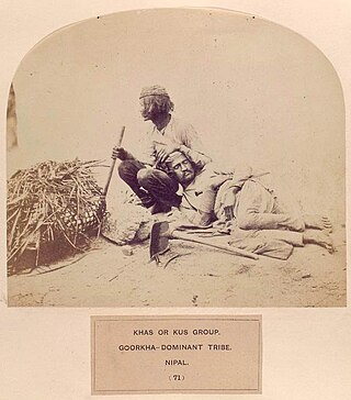
Khas people, popularly known as Khas Arya, according to the constitution of 2072 BS of Nepal are an Indo-Aryan ethno-linguistic group native to the Himalayan region of the Indian subcontinent, in what is now the present-day South Asian country of Nepal, as well as the Indian states of Uttarakhand, West Bengal and Sikkim. Historically, Khas were the speakers of an ancient Khas language from the Indo-Aryan language family and the earliest recorded speakers of the Western Pahari languages. The large portion of the Indo-Aryan speakers throughout lower Himalayas were the Khas people. An intrusion of this tribe from the Western and Northwestern Himalayas into Central Himalayas is substantiated by the early linguistic evidences related to the Nepali language. They were also known as Parbatiyas/Parbates and are currently known as Paharis/Pahadis.. They were also referred to as Yartse in Tibet and are also known as Khasan by Bhotia people. The term Khas has now become obsolete, as the Khas people have adopted communal identities because of the negative stereotypes associated with the term Khas. In Nepal the native speaker of Nepali language are known as Khas.

<span class="mw-page-title-main">Doti District</span> District in Sudurpashchim Province, Nepal

Doti District, part of Sudurpashchim Province, is one of the 77 districts of Nepal. This district, with Silgadhi as its headquarters, covers an area of 2,025 square kilometres (782 sq mi) with a population of 207,066 in 2001 and increasing marginally to 211,746 in 2011.

<span class="mw-page-title-main">Didihat</span> Town in Uttarakhand, India

Didihat is a town and a Nagar Palika in Pithoragarh District in the state of Uttarakhand, India. It is one of the eleven administrative subdivisions of Pithoragarh district and also serves as its administrative headquarter. With a population of 6522, Didihat is located at a distance of 415 km (258 mi) from the state capital Dehradun.

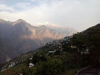
Askot or Askote (Kumaoni:असकोट) is a small Himalayan town in Pithoragarh district of Uttarakhand in India. It is the part of Kanalichhina development Block and Didihat Tehsil.

<span class="mw-page-title-main">Chand kings</span> Medieval Indian Chandel dynasty of Kumaon

The Chand Dynasty, sometimes Chandel of Kumaon or Chand Kingdom, was a Hindu dynasty of Kumaon, which was established by displacing the Katyuri kings. The Chands ruled over the Kumaon and parts of the Farwestern Nepal called Doti. They belonged to the Somvanshi Chandel Yadava dynasty of Rajputs.

<span class="mw-page-title-main">Doti</span> Region in Nepal

Doti, also known as Doti region, Dotigarh (डोटीगढ़) as used in the Jagar, in the Farwestern region of Nepal, is a region situated between River Kali bordering Kumaon division of Uttarakhand, India in the west and the Karnali river on the east. Doti was one of eight different princely states of the Katyuri Kingdom.

<span class="mw-page-title-main">Pithoragarh</span> Town in Uttarakhand, India

Pithoragarh is a Himalayan town with a Municipal Board in Pithoragarh district in the Indian state of Uttarakhand. It is the largest hill town in Kumaon Division.

<span class="mw-page-title-main">Bageshwar district</span> District of Uttarakhand in India

Bageshwar is a district of Uttarakhand state in northern India. The town of Bageshwar is the district headquarters. Prior to its establishment as a district in 1997 it was part of Almora district.

<span class="mw-page-title-main">Bageshwar</span> Town in Uttarakhand, India

Bageshwar is a town and a municipal board in Bageshwar district in the state of Uttarakhand, India. It is located at a distance of 470 km from the National Capital New Delhi and 332 km from the State Capital Dehradun. Bageshwar is known for its scenic environment, glaciers, rivers and temples. It is also the administrative headquarters of Bageshwar district.

<span class="mw-page-title-main">Lohaghat</span> City in Uttarakhand, India

Lohaghat is a town and a nagar palika in Champawat district in the Indian state of Uttarakhand.

<span class="mw-page-title-main">Garur</span> Town in Uttarakhand

Garur is a town in the Bageshwar district of the state of Uttarakhand, India.

<span class="mw-page-title-main">Baijnath, Uttarakhand</span> Town in Uttarakhand, India

Baijnath is a small town on the banks of the Gomati river in the Bageshwar district in Kumaon division of Uttarakhand, India. The place is most noted for its ancient temples, which have been recognized as Monuments of National Importance by the Archaeological Survey of India in Uttarakhand. Baijnath has been selected as one of the four places to be connected by the 'Shiva Heritage Circuit' in Kumaon, under the Swadesh Darshan Scheme of the Government of India.

<span class="mw-page-title-main">History of Uttarakhand</span> State

Uttarakhand is a state in North India. Its name, which means "northern land" or "section" or "northern part" in Sanskrit, is mentioned in early Hindu texts as the combined region of Kedarkhand and Manaskhand.

<span class="mw-page-title-main">Far-Western Development Region, Nepal</span> Regions in Far-Western Development Region, Nepal

The Far-Western Development Region was one of Nepal's five development regions. It was located at the western end of the country and had its headquarters in Dipayal.

<span class="mw-page-title-main">Chholiya</span> Dance form practised in the [[Kumaon division|Kumaon]] region of India

Chholiya or Hudkeli is a traditional folk dance form originated in the Kumaon division of the Indian state of Uttarakhand and Sudurpashchim province of Nepal. It has today become a symbol of Kumaoni and Sudurpashchimi cultures. It is basically a sword dance accompanying a marriage procession but now it is performed on many auspicious occasions.

<span class="mw-page-title-main">Kumaon Kingdom</span> Independent Himalayan kingdom (600–1791)

Kumaon Kingdom was an independent Himalayan kingdom in Kumaon, a region located in the eastern part of the present-day Uttarakhand state of India. It was established around 7th century and remained an independent and sovereign kingdom until 1791.

<span class="mw-page-title-main">Sudurpashchim Province</span> Province of Nepal

Sudurpashchim Province is one of the seven provinces established by the new constitution of Nepal which was adopted on 20 September 2015. It borders the Tibet Autonomous Region of China to the north, Karnali Province and Lumbini Province to the east, and India's states of Uttarakhand and Uttar Pradesh to the west and south, respectively. The province covers an area of 19,539 km2, or about 13.22% of the country's total area. Initially known as Province No. 7, the newly elected Provincial Assembly adopted Sudurpashchim Province as the permanent name for the province in September 2018. As per a 28 September 2018 Assembly voting, the city of Godawari has been declared the capital of the Province, But till now Dhangadhi serves as the temporary capital. The province is coterminous with the former Far-Western Development Region, Nepal. The three major cities in terms of population and economy are Dhangadhi, Bhimdutta (Mahendranagar), and Tikapur.

<span class="mw-page-title-main">Baijnath Temple Complex</span> Cluster of 18 Hindu temples, Baijnath, Uttarakhand, India

Baijnath Temple Complex is a cluster of 18 Hindu temples which are situated in the town of Baijnath in Uttarakhand, India. The complex is located in Bageshwar district along the banks of Gomati river at an elevation of 1,125 m (3,691 ft) above the mean sea level. These temples are renowned for possibly being one of the very few temples in the world where Parvati is depicted with her husband Shiva. Pilgrims arrive here on occasion of Shivratri and Makar Sankranti.

References

Notes

    1. Most of the scholars agreed upon the Khasha origin of Katyuris. [4] However, Historians Badri Datt Pandey and Price Powell respectively proposed descent from Shalivahana ruling house of Ayodhya and Kuninda both of which are seriously doubtful over various internal evidences that shows the Katyuris belonged to the Khasha people that entirely dominated the inner Himalayan belt upto Nepal. [5]
    2. Pandey states the Khasas to be the original inhabitants of these Himalayan areas, who settled here before the composition of the Vedas, and the Katyuris may have conquered them, and established their Kingdom. [14]

    Citations

    1. Schwartzberg, Joseph E. (1978). A Historical atlas of South Asia. Chicago: University of Chicago Press. p. 37, 147. ISBN   0226742210.
    2. 1 2 3 Handa 2002 , p. 24
    3. 1 2 3 4 Handa 2002 , p. 25
    4. 1 2 3 4 5 6 Handa 2002, p. 22.
    5. 1 2 Handa 2002, p. 24-25.
    6. 1 2 3 4 5 6 Handa 2002 , p. 26
    7. Handa 2002, p. 29-31.
    8. Handa 2002, p. 31.
    9. 1 2 3 4 5 6 Handa 2002 , pp. 34–45
    10. Handa 2002, p. 38-44.
    11. Royle, John Forbes (1839). Illustrations of the Botany and Other Branches of the Natural History of the Himalayan Mountains (etc.). Allen.
    12. Alter, Andrew (2014), "Echoes of Colonialism: Bagpipes in the Himalayas", Mountainous Sound Spaces, Delhi: Foundation Books, pp. 1–16, doi:10.1017/9789384463069.003, ISBN   978-93-84463-06-9 , retrieved 10 November 2020
    13. 1 2 3 Pande 1993 , p. 154
    14. Pande 1993, p. 152
    15. Handa 2002, p. 25.
    16. Handa 2002 , pp. 22–26
    17. Handa 2002, p. 24.
    18. Handa 2002, pp. 26–28.
    19. Nachiket Chanchani 2013, pp. 139–141.
    20. "9th-11th century". Archived from the original on 20 April 2008. Retrieved 9 June 2008.
    21. Hāṇḍā, Omacanda (2008). Panorama of Himalayan architecture. Indus. ISBN   978-81-7387-212-9.
    22. Srinivas, Vijay. Jewel of the sacred Himalayas. OCLC   1010658966.
    23. Atkinson, Edwin T. (Edwin Thomas) (1990). Himalayan Gazetteer. Cosmo. OCLC   183008777.
    24. Handa 2002, p. 28 to 32.
    25. "Historical Background". Uttarakhand Open University. Archived from the original on 14 June 2013. Retrieved 29 June 2013.
    26. Sajwan, Venita (17 August 2002). "A lesser-known sun temple at Katarmal". The Tribune. Retrieved 8 July 2013.

    Bibliography