Kumaon is a revenue and administrative division in the Indian State of Uttarakhand. It spans over the eastern half of the state and is bounded on the north by Tibet, on the east by Nepal, on the south by the state of Uttar Pradesh, and on the west by Garhwal. Kumaon comprises six districts of the state: Almora, Bageshwar, Champawat, Nainital, Pithoragarh and Udham Singh Nagar.

Uttarakhand, also known as Uttaranchal, is a state in northern India. It is often referred to as the "Devbhumi" due to its religious significance and numerous Hindu temples and pilgrimage centres found throughout the state. Uttarakhand is known for the natural environment of the Himalayas, the Bhabar and the Terai regions. It borders the Tibet Autonomous Region of China to the north; the Sudurpashchim Province of Nepal to the east; the Indian states of Uttar Pradesh to the south and Himachal Pradesh to the west and north-west. The state is divided into two divisions, Garhwal and Kumaon, with a total of 13 districts. The winter capital of Uttarakhand is Dehradun, the largest city of the state, which is a rail head. Gairsain, a town in Chamoli district, is the summer capital of Uttarakhand declared on 5 March 2020. The High Court of the state is located in Nainital, but is to be moved to Haldwani in future.

Almora is a district in the Kumaon Division of Uttarakhand state, India. The headquarters is at Almora. It is 1,638 meters above sea level. The neighbouring regions are Pithoragarh district to the east, Chamoli district to the west, Bageshwar district to the north and Nainital district to the south.

Haldwani is the largest city of Kumaon. It is also the third most populous city and largest commercial market in the Indian state of Uttarakhand. Haldwani is said to be the financial capital of Uttarakhand, having the most commercial, economic and industrial activities of the state. Haldwani is located in the Nainital District, and is one of its eight Subdivisions. The Haldwani Urban agglomeration has 232,060 people as of 2011, and is the third most populous UA in Uttarakhand, after Dehradun and Haridwar. Being situated in the immediate foothills of Kumaon Himalayas, the Kathgodam neighbourhood of Haldwani is known as the "Gateway to Kumaon".
Gairsain is a town in Chamoli district of the Indian state of Uttarakhand near state's summer capital Bhararisain. A town and Nagar Panchayat, Gairsain is situated at the eastern edge of the vast Dudhatoli mountain range, and is located in Chamoli district almost at the centre of the state, at a distance of approximately 250 kilometres from Dehradun. It is easily accessible from both the Garhwal and the Kumaon divisions, and in a way, acts as the bridge between the two regions. It is being considered as the future Permanent capital of Uttarakhand.

Nainital district is a district in Kumaon division which is a part of Uttarakhand state in India. The headquarters is at Nainital.
Pauri Garhwal is a district in the Indian state of Uttarakhand. Its headquarters is in the town of Pauri. It is sometimes referred to simply as Garhwal district, though it should not be confused with the larger Garhwal region of which it is only a part of.

Tehri Garhwal is a district in the hill state of Uttarakhand, India. Its administrative headquarters is at New Tehri. The district has a population of 618, 931, a 2.35% increase over the previous decade. It is surrounded by Rudraprayag District in the east, Dehradun District in the west, Uttarkashi District in the north, and Pauri Garhwal District in the south. Tehri Garhwal is a part of the Himalayas.

Rudraprayag is a district of the state of Uttarakhand of northern India. The district occupies an area of 1984 km2. The town of Rudraprayag is the administrative headquarters of the district. The district is bounded by Uttarkashi District on the north, Chamoli District on the east, Pauri Garhwal District on the south, and Tehri Garhwal District on the west.

Bageshwar is a district of Uttarakhand state in northern India. The town of Bageshwar is the district headquarters. Prior to its establishment as a district in 1997 it was part of Almora district.
Bageshwar is a town and a municipal board in Bageshwar district in the state of Uttarakhand, India. It is located at a distance of 470 km from the National Capital New Delhi and 332 km from the State Capital Dehradun. Bageshwar is known for its scenic environment, glaciers, rivers and temples. It is also the administrative headquarters of Bageshwar district.
Uttarakhand is a state in North India. Its name, which means "northern land" or "section" or "northern part" in Sanskrit, is mentioned in early Hindu texts as the combined region of Kedarkhand and Manaskhand.

The Garhwali people are an Indian ethnolinguistic group native to the Garhwal, in the Indian state of Uttarakhand, who speak Garhwali, an Indo-Aryan language.

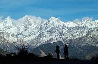
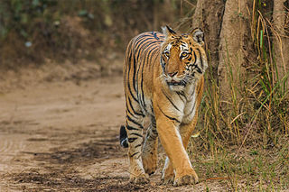
Uttarakhand has a total geographic area of 53,483 km2, of which 86% is mountainous and 65% is covered by forest. Most of the northern parts of the state are part of Greater Himalaya ranges, covered by the high Himalayan peaks and glaciers, while the lower foothills were densely forested till denuded by the British log merchants and later, after independence, by forest contractors. Recent efforts in reforestation, however, have been successful in restoring the situation to some extent. The unique Himalayan ecosystem plays host to many animals, plants and rare herbs. Two of India's great rivers, the Ganges and the Yamuna take birth in the glaciers of Uttarakhand, and are fed by myriad lakes, glacial melts and streams.

Garhwal Kingdom was an independent Himalayan kingdom in the current north-western Himalayan state of Uttarakhand, India, founded in 688 CE by Kanak Pal, the progenitor of the Panwar dynasty that ruled over the kingdom uninterrupted until 1803 CE.
The Uttarakhand Fire and Emergency Services is the public service department of the Government of Uttarakhand whose function is to firefighting and emergency services in Uttarakhand. It is responsible for the provision of fire protection and life safety as well as responding to building collapses, drownings, gas leakage, oil spillage, road and rail accidents, bird and animal rescues, fallen trees and taking appropriate action during natural disasters. The department has now 47 fire stations consisting of nearly 1400 executive personnel and nearly 98 ministerial staff. The headquarters the department is situated at Dehradun.
