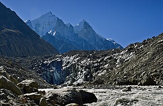
Gangotriglacier is located in Uttarkashi District, Uttarakhand, India in a region bordering Tibet. This glacier, one of the primary sources of the Ganges, has a volume of over 27 cubic kilometers. The glacier is about 30 kilometres long and 2 to 4 km wide. Around the glacier are the peaks of the Gangotri Group, including several peaks notable for extremely challenging climbing routes, such as Shivling, Thalay Sagar, Meru, and Bhagirathi III. It flows roughly northwest, originating in a cirque below Chaukhamba, the highest peak of the group.
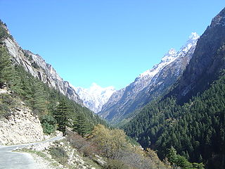
Gangotri is a town and a Nagar Panchayat (municipality) in Uttarkashi district in the state of Uttarakhand, India. It is 99 km from Uttarkashi, the main district headquarter. It is a Hindu pilgrim town on the banks of the river Bhagirathi – the origin of the river Ganges. The town is located on the Greater Himalayan Range, at a height of 3,100 metres (10,200 ft). According to a popular Hindu legend, the goddess Ganga descended here when Shiva released the mighty river from the locks of his hair.
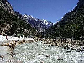
The Bhāgīrathī is a turbulent Himalayan river in the Indian state of Uttarakhand, and one of the two headstreams of the Ganges, the major river of Northern India and the holy river of Hinduism. In the Hindu faith, history, and culture, the Bhagirathi is considered the source stream of the Ganges. However, in hydrology, the other headstream Alaknanda, is considered the source stream on account of its great length and discharge. The Bhagirathi and Alaknanda join at Devprayag in Garhwal and are thereafter known as the Ganges.

Gangotri National Park is a national park in Uttarkashi District in the eponymous state in India, covering about 2,390 km2 (920 sq mi). Its habitat consists of coniferous forests, alpine meadows and glaciers. Gaumukh at Gangotri glacier, the origin of the river Ganga, is located inside the park. Gangotri National Park was established in 1989.

Uttarkashi, meaning Kashi of the north, is a town located in Uttarkashi district in Uttarakhand, India. Uttarkashi town is headquarters of the district. Uttarkashi is also known as Somya Kashi. Uttarkashi is a Hindu religious place for spiritual and adventurous tourism. Uttarkashi town is also called as Shivnagri. The town has number of temples and ashrams. Uttarkashi is known for its religious people, weather, education.

Tapovana (Sanskrit) comes from the two root words tapas, meaning 'penance' and by extension 'religious mortification' and 'austerity', and more generally 'spiritual practice', and vana, meaning 'forest' or 'thicket'. Tapovana then translates as 'forest of austerities or spiritual practice'. Though pronounced the same in Hindi, tapovana should not be confused with tapovan, which means a person engaged in austerity.
Gangotri is a town and pilgrimage centre in Uttarakhand, India.

Bhilangna River is a Himalayan river in Uttarakhand, India, which is the major tributary of the Bhagirathi river, the source stream of the Ganges River of India. Bhilangana is a combination of Bhil and Ganga.

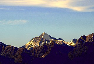
Shivling is a mountain in the Gangotri Group of peaks in the western Garhwal Himalaya, near the snout of the Gangotri Glacier, one of the biggest glaciers in the Himalayas, and Tapovan, a beautiful lush meadows, both being also popular pilgrimage sites in Hinduism. It lies in the northern Indian state of Uttarakhand, 6 kilometres (4 mi) south of the Hindu holy site of Gaumukh. Its name refers to its status as a sacred symbol – Shiva Linga. It was called "Matterhorn Peak" by early European visitors because of its similarity in appearance to that Alpine peak. While not of locally great elevation, it is a dramatic rock peak, and the most visually striking peak as seen from Gaumukh; that and the difficulty of the climb make it a famed prize for mountaineers.

Swami Sundaranand was an Indian Yogi, photographer, author and mountaineer who lectured widely in India on threats to the Ganges River and the loss of Himalayan glaciers due to global warming.
Nelang or Nilang is a river valley of the Himalayas, containing a small eponymous village, in the Uttarkashi District of the state of Uttarakhand, India. It is close to the disputed Sino-Indian Line of Actual Control (LAC), and is also claimed by China as part of Zanda County of Ngari Prefecture of Tibet.
Maneri is a town in Uttarakhand, India. Situated on the banks of river Bhagirathi 8 km north of Uttarkashi, it is the home of Maneri Dam and the terminating railway station on Chota Char Dham Railway nearest to Gangotri.

Bhagirathi Massif or Bhagirathi Group is a mountain range of Garhwal Himalaya in Gangotri Glacier Uttarakhand India, It has four peaks between 6856 meter and 6193 meter. The Bhagirathi I summits is 6856 meter or 22493 feet. It was first climbed by A Japanese team in 1980. It is surrounded by Glaciers on four side on the eastern side of the Massif is Vasuki Glacier, on the western side its Gangotri Glacier the main glacier in this area, northern side is surrounded by Chaturangi Glacier and southern side guarded by Swachhhand Glacier.

Vasuki Parbat or Vasuki Parvat is a mountain range of Garhwal Himalaya in Vasuki Glacier Uttarakhand, India. It has a subsidiary peak, Vasuki south. Vasuki Parbat stands majestically at 6792 meter and the south peak 6702 at meter. Its the 35th highest located entirely within the uttrakhand India. Nanda Devi, is the highest mountain in this category.
Chaturbhuj is a mountain of the Garhwal Himalaya in Uttarakhand, India. The elevation of Chaturbhuj is 6,654 metres (21,831 ft) and its prominence is 357 metres (1,171 ft). It is 52nd highest located entirely within the Uttrakhand. Nanda Devi, is the highest mountain in this category. Chaturbhuj lies between the Matri 6,721 metres (22,051 ft) and Shwetvarn 6,340 metres (20,801 ft). Its nearest higher neighbor Yogeshwar lies 2.7 km east. It is located 5.9 km NW of chirbas Parbat 6,529 metres (21,421 ft) and 8.5 km east lies Sri Kailash 6,932 metres (22,743 ft).
Satopanth South West also called P. 6770 is a mountain of the Garhwal Himalaya in Uttarakhand, India. The elevation of Satopanth south west is 6,770 metres (22,211 ft) and its prominence is 195 metres (640 ft). It is 40th highest located entirely within the Uttrakhand. Nanda Devi, is the highest mountain in this category. It lies in the same connecting ridge that joins Satopanth and Bhagirathi Parbat I. It lies 1.8 km SW of Satopanth. Its nearest higher neighbor Satopanth 7,075 metres (23,212 ft). It is located 3.4 km SE of Vasuki South 6,702 metres (21,988 ft) and 5.2 km NNW lies Bhagirathi I 6,856 metres (22,493 ft).
Jogin I is a mountain of the Garhwal Himalaya in Uttarakhand India.The elevation of Jogin I is 6,465 metres (21,211 ft) and its prominence is 843 metres (2,766 ft). It is 94th highest located entirely within the Uttrakhand. Nanda Devi, is the highest mountain in this category. It lies 5.4 km east of Gangotri III and 7.4 km west of Bhrigupanth 6,772 metres (22,218 ft). It lies 2.2 km South of Jogin II. Its nearest higher neighbor is Gangotri III 6,577 metres (21,578 ft). It is located 6.9 km NW of Thalaysagar 6,904 metres (22,651 ft) and 8.8 km NW lies Gangotri I 6,682 metres (21,923 ft).
Jogin II is a mountain of the Garhwal Himalaya in Uttarakhand India.The elevation of Jogin II is 6,342 metres (20,807 ft) and its prominence is 259 metres (850 ft). It is 110th highest located entirely within the Uttrakhand. Nanda Devi, is the highest mountain in this category. It lies 6.2 km east of Gangotri III and 7 km west of Bhrigupanth 6,772 metres (22,218 ft). It lies 2.2 km north of Jogin I. Its nearest higher neighbor is Jogin I 6,465 metres (21,211 ft). It is located 7.2 km NW of Thalay Sagar 6,904 metres (22,651 ft) and 8.5 km NW lies Gangotri I 6,682 metres (21,923 ft).
Vasuki Parbat South is a mountain of the Garhwal Himalaya in Uttarakhand, India. The elevation of Vasuki Parbat South is 6,702 metres (21,988 ft) and its prominence is 280 metres (919 ft). It is 49th highest located entirely within the Uttrakhand. Nanda Devi, is the highest mountain in this category. It lies 1.6 km south of Vasuki Parbat its nearest higher neighbor 6,792 metres (22,283 ft) and 2.7 km east of Bhagirathi Parbat I 6,856 metres (22,493 ft). It is located 4.6 km SE of Bhagirathi Parbat II 6,512 metres (21,365 ft) and 4.1 km SE lies Satopanth 7,075 metres (23,212 ft).
Shwetvarna is a mountain of the Garhwal Himalaya in Uttarakhand India.The elevation of Shwetvarna is 6,340 metres (20,801 ft) and its prominence is 240 metres (787 ft). It is 111th joint highest located entirely within the Uttrakhand. Nanda Devi, is the highest mountain in this category. It lies 1.2 km SSE of Chaturbhuj 6,654 metres (21,831 ft) its nearest higher neighbor and it is 1.2 km SSW of Sudarshan Parbat 6,507 metres (21,348 ft). It lies 3 km NW of Shyamvarn 6,135 metres (20,128 ft).


