Bailey, North Carolina

Last updated

Bailey, North Carolina
Bailey, North Carolina.jpg
Nash County North Carolina incorporated and unincorporated areas Bailey highlighted.svg
Location in Nash County and the state of North Carolina.
Coordinates: 35°46′50″N78°06′47″W / 35.78056°N 78.11306°W / 35.78056; -78.11306
Country United States
State North Carolina
County Nash
Area
[1]
  Total0.70 sq mi (1.82 km2)
  Land0.70 sq mi (1.82 km2)
  Water0.00 sq mi (0.00 km2)
Elevation
[2]
249 ft (76 m)
Population
 (2020)
  Total568
  Density809.12/sq mi (312.43/km2)
Time zone UTC-5 (Eastern (EST))
  Summer (DST) UTC-4 (EDT)
ZIP code
27807
Area code 252
FIPS code 37-03020 [3]
GNIS feature ID2405197 [2]

Bailey is a town in Nash County, North Carolina, United States. It is part of the Rocky Mount, North Carolina Metropolitan Statistical Area. The population was 566 at the 2020 census.

Contents

History

The Morgan School was listed on the National Register of Historic Places in 2006. [4]

Geography

According to the United States Census Bureau, the town has a total area of 0.7 square miles (1.8 km2), all land.

Demographics

Historical population
CensusPop.Note
1910 195
1920 518165.6%
1930 63121.8%
1940 6452.2%
1950 74315.2%
1960 7957.0%
1970 724−8.9%
1980 685−5.4%
1990 553−19.3%
2000 67021.2%
2010 569−15.1%
2020 568−0.2%
U.S. Decennial Census [5]

At the 2000 census there were 670 people, 274 households, and 184 families in the town. The population density was 955.8 inhabitants per square mile (369.0/km2). There were 302 housing units at an average density of 430.8 per square mile (166.3/km2). The racial makeup of the town was 67.91% White, 22.84% African American, 7.46% from other races, and 1.79% from two or more races. Hispanic or Latino of any race were 10.75%. [3]

Of the 274 households 26.3% had children under the age of 18 living with them, 52.6% were married couples living together, 10.9% had a female householder with no husband present, and 32.5% were non-families. 29.2% of households were one person and 13.5% were one person aged 65 or older. The average household size was 2.45 and the average family size was 2.98.

The age distribution was 23.6% under the age of 18, 9.3% from 18 to 24, 26.9% from 25 to 44, 22.2% from 45 to 64, and 18.1% 65 or older. The median age was 38 years. For every 100 females, there were 97.1 males. For every 100 females age 18 and over, there were 88.2 males.

The median household income was $36,328 and the median family income was $43,750. Males had a median income of $33,929 versus $25,179 for females. The per capita income for the town was $21,910. About 6.7% of families and 11.2% of the population were below the poverty line, including 21.4% of those under age 18 and 7.9% of those age 65 or over.

Notable people

Related Research Articles

<span class="mw-page-title-main">Millport, Alabama</span> Town in Alabama, United States

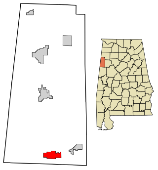
Millport is a town in Lamar County, Alabama, United States. It incorporated in 1887. At the 2010 census the population was 1,049, down from 1,160 in 2000. After its incorporation from 1890 to 1900, it was the largest town in Lamar County, losing the distinction to Sulligent. Since 1940, it has been the 3rd largest town.

<span class="mw-page-title-main">Monroe, Adams County, Indiana</span> Town in Indiana, United States

Monroe is a town in Washington and Monroe townships, Adams County, Indiana, United States. The population of the town was 945 residents at the 2019 census. Adams Central Community Schools is located in Monroe.

<span class="mw-page-title-main">Swepsonville, North Carolina</span> Town in North Carolina, United States

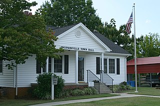
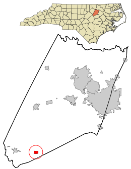
Swepsonville is a town in Alamance County, North Carolina, United States. It is part of the Burlington, North Carolina Metropolitan Statistical Area. The population at the 2010 census was 1,154.

<span class="mw-page-title-main">Powellsville, North Carolina</span> Town in North Carolina, United States

Powellsville is a town in Bertie County, North Carolina, United States. The population was 276 at the 2010 census. The city is home to Travis Bond

Varnamtown is a town in Brunswick County, North Carolina, United States situated on the banks of the Lockwood Folly River. The population was 541 at the 2010 census. It is part of the Wilmington, NC Metropolitan Statistical Area.

<span class="mw-page-title-main">Catawba, North Carolina</span> Town in North Carolina, United States

Catawba is a town in Catawba County, North Carolina, United States. The population was 603 at the 2010 census. It is part of the Hickory–Lenoir–Morganton Metropolitan Statistical Area. As with the county, the name recalls the Catawba people, the indigenous people who once inhabited the area.

<span class="mw-page-title-main">Earl, North Carolina</span> Town in North Carolina, United States

Earl is a town in Cleveland County, North Carolina, United States. The population was 260 at the 2010 census.

<span class="mw-page-title-main">Lawndale, North Carolina</span> Town in North Carolina, United States

Lawndale is a town in Cleveland County, North Carolina, United States, situated along the First Broad River. The population was 606 at the 2010 census.

<span class="mw-page-title-main">Wade, North Carolina</span> Town in North Carolina, United States

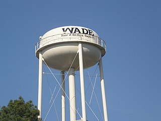
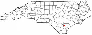
Wade is a town in Cumberland County, North Carolina, United States. The population was 556 at the 2010 census.

<span class="mw-page-title-main">Calypso, North Carolina</span> Town in North Carolina, United States

Calypso is a town in Duplin County, North Carolina, United States. As of the 2020 census, the population was 327. At the previous census in 2010, the population was 538.

<span class="mw-page-title-main">Pleasant Garden, North Carolina</span> Town in North Carolina, United States

Pleasant Garden is a town in Guilford County, North Carolina, United States.

<span class="mw-page-title-main">Sedalia, North Carolina</span> Town in North Carolina, United States

Sedalia is a town in Guilford County, North Carolina, United States. As of the 2020 census, the population of the town was 676.

<span class="mw-page-title-main">Oak City, North Carolina</span> Town in North Carolina, United States

Oak City, formerly known as Goose Nest, is a town in Martin County, North Carolina, United States. The population was 266 at the 2020 census.

<span class="mw-page-title-main">Spring Hope, North Carolina</span> Town in North Carolina, United States

Spring Hope is a town in Nash County, North Carolina, United States. It is part of the Rocky Mount, North Carolina Metropolitan Statistical Area. The population was 1,320 at the 2010 census.

<span class="mw-page-title-main">Garysburg, North Carolina</span> Town in North Carolina, United States

Garysburg is a town in Northampton County, North Carolina, United States. The population was 1,057 at the 2010 census. It is part of the Roanoke Rapids, North Carolina Micropolitan Statistical Area.

<span class="mw-page-title-main">Minnesott Beach, North Carolina</span> Town in North Carolina, United States

Minnesott Beach is a town in Pamlico County, North Carolina, United States. The population was 440 at the 2010 census. It is part of the New Bern, North Carolina Metropolitan Statistical Area.

<span class="mw-page-title-main">Atkinson, North Carolina</span> Town in North Carolina, United States

Atkinson is a town in Pender County, North Carolina, United States. At the 2010 census, the town population was 299. It is part of the Wilmington Metropolitan Statistical Area. The town was incorporated in 1989.

<span class="mw-page-title-main">Faith, North Carolina</span> Town in North Carolina, United States

Faith is a town in Rowan County, North Carolina, United States, incorporated in 1903. The population was 807 at the 2010 census.

<span class="mw-page-title-main">Snelling, South Carolina</span> Town in South Carolina, United States

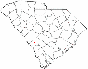
Snelling is a town in Barnwell County, South Carolina, United States. The population was 274 at the 2010 census.

<span class="mw-page-title-main">Hollywood, South Carolina</span> Town in South Carolina, United States

Hollywood is a town in Charleston County, South Carolina, United States. The population was 4,714 at the 2010 census, up from 3,946 in 2000. Hollywood is part of the Charleston, South Carolina metropolitan area and the Charleston-North Charleston Urbanized Area.

References

  1. "ArcGIS REST Services Directory". United States Census Bureau. Retrieved September 20, 2022.
  2. 1 2 U.S. Geological Survey Geographic Names Information System: Bailey, North Carolina
  3. 1 2 "U.S. Census website". United States Census Bureau . Retrieved January 31, 2008.
  4. "National Register Information System". National Register of Historic Places . National Park Service. July 9, 2010.
  5. "Census of Population and Housing". Census.gov. Retrieved June 4, 2015.
  6. Harrison, Conor M. (2014). Power For All? Electricity and Uneven Development in North Carolina (PDF) (Thesis). University of North Carolina. p. 120.