Middlesex, North Carolina

Last updated

Middlesex, North Carolina
Middlesex, North Carolina 03.jpg
Nash County North Carolina incorporated and unincorporated areas Middlesex highlighted.svg
Location in Nash County and the state of North Carolina.
Coordinates: 35°47′22″N78°12′17″W / 35.78944°N 78.20472°W / 35.78944; -78.20472
Country United States
State North Carolina
County Nash
Area
[1]
  Total1.04 sq mi (2.71 km2)
  Land1.04 sq mi (2.71 km2)
  Water0.00 sq mi (0.00 km2)
Elevation
[2]
259 ft (79 m)
Population
 (2020)
  Total912
  Density872.73/sq mi (336.92/km2)
Time zone UTC-5 (Eastern (EST))
  Summer (DST) UTC-4 (EDT)
ZIP code
27557
Area code 252
FIPS code 37-42700 [3]
GNIS feature ID2406157 [2]
Website www.townofmiddlesexnc.com

Middlesex is a town in Nash County, North Carolina, United States. It is part of the Rocky Mount, North Carolina Metropolitan Statistical Area. Middlesex is about 25 miles east of Raleigh. The population was 822 at the 2010 census.

Contents

Geography

According to the United States Census Bureau, the town has a total area of 1.0 square mile (2.6 km2), all land.

Demographics

Historical population
CensusPop.Note
1910 467
1920 69749.3%
1930 559−19.8%
1940 545−2.5%
1950 446−18.2%
1960 58831.8%
1970 72924.0%
1980 83714.8%
1990 730−12.8%
2000 83814.8%
2010 822−1.9%
2020 91210.9%
U.S. Decennial Census [4]

As of the census [3] of 2000, there were 838 people, 381 households, and 235 families residing in the town. The population density was 858.6 inhabitants per square mile (331.5/km2). There were 426 housing units at an average density of 436.5 per square mile (168.5/km2). The racial makeup of the town was 63.25% White, 32.70% African American, 0.24% Native American, 3.58% from other races, and 0.24% from two or more races. Hispanic or Latino of any race were 7.52% of the population.

There were 381 households, out of which 27.0% had children under the age of 18 living with them, 41.2% were married couples living together, 16.8% had a female householder with no husband present, and 38.1% were non-families. 34.6% of all households were made up of individuals, and 18.1% had someone living alone who was 65 years of age or older. The average household size was 2.20 and the average family size was 2.81.

In the town, the population was spread out, with 23.3% under the age of 18, 10.3% from 18 to 24, 25.1% from 25 to 44, 23.2% from 45 to 64, and 18.3% who were 65 years of age or older. The median age was 38 years. For every 100 females, there were 87.9 males. For every 100 females age 18 and over, there were 82.2 males.

The median income for a household in the town was $21,458, and the median income for a family was $26,488. Males had a median income of $23,182 versus $19,886 for females. The per capita income for the town was $13,717. About 21.4% of families and 21.8% of the population were below the poverty line, including 30.3% of those under age 18 and 23.5% of those age 65 or over.

Notable people

Related Research Articles

<span class="mw-page-title-main">Middlesex County, Connecticut</span> County in Connecticut, United States

Middlesex County is a county in the south central part of the U.S. state of Connecticut. As of the 2020 census, the population was 164,245. The county was created in May 1785 from portions of Hartford County and New London County.

Saybrook Manor is a community and census-designated place (CDP) in Old Saybrook, a town in Middlesex County, Connecticut, United States. The population was 1,127 at the 2020 census. The Saybrook Manor section is generally the area south of U.S. Route 1 between the Westbrook town line and the Oyster River.

<span class="mw-page-title-main">McCordsville, Indiana</span> Town in Indiana, United States

McCordsville is a town in Vernon Township, Hancock County, Indiana, United States. The town is a fast-growing suburb of Indianapolis with an estimated population of 8,592 in 2020.

<span class="mw-page-title-main">Hazleton, Iowa</span> City in Iowa, United States

Hazleton is a city in Buchanan County, Iowa, United States. The population was 713 at the time of the 2020 census.

<span class="mw-page-title-main">New Limerick, Maine</span> Town in the state of Maine, United States

New Limerick is a town in Aroostook County, Maine, United States. The population was 574 at the 2020 census. The town was settled in 1775 and incorporated on March 18, 1837, from New Limerick Plantation. It received its name from the fact that many of its settlers had previously lived in Limerick in York County at the southern end of the state, which in turn was probably named after the Irish city of Limerick.

<span class="mw-page-title-main">Cedar Point, North Carolina</span> Town in North Carolina, United States

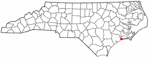
Cedar Point is a town in Carteret County, North Carolina, United States. The population was 1,297 in 2010.

Boardman is a town in Columbus County, North Carolina, United States. Per the 2020 census, the population was 166.

<span class="mw-page-title-main">West Canton, North Carolina</span> Census-designated place in North Carolina, United States

West Canton is an unincorporated community and census-designated place (CDP) in Haywood County, North Carolina, United States. The population was 1,247 at the 2010 census. It is part of the Asheville Metropolitan Statistical Area.

<span class="mw-page-title-main">Gratis, Ohio</span> Village in Ohio, United States

Gratis is a village in Preble County, Ohio, United States. The population was 842 at the 2020 census. It is part of the Dayton Metropolitan Statistical Area.

<span class="mw-page-title-main">Middlesex Township, Butler County, Pennsylvania</span> Township in Pennsylvania, United States

Middlesex Township is a township in Butler County, Pennsylvania, United States. The population was 6,826 at the 2020 census.

<span class="mw-page-title-main">Ceres Township, Pennsylvania</span> Township in Pennsylvania, United States

Ceres Township is a township in McKean County, Pennsylvania, United States. The population was 842 at the 2020 census.

Ulmer is a town in Allendale County, South Carolina, United States. The population was 65 at the 2020 census.

<span class="mw-page-title-main">Hilda, South Carolina</span> Town in South Carolina, United States

Hilda is a town in Barnwell County, South Carolina, United States. The population was 447 at the 2010 census..

<span class="mw-page-title-main">Elloree, South Carolina</span> Town in South Carolina, United States

Elloree is a town in Orangeburg County, South Carolina, United States. The population was 692 at the 2010 census.

<span class="mw-page-title-main">Lesslie, South Carolina</span> CDP in South Carolina, United States

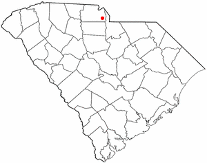
Lesslie is a census-designated place located in York County, South Carolina, United States, southeast of the city of Rock Hill. In 2010, Lesslie had a total population of 2,882 people.

<span class="mw-page-title-main">Cable, Wisconsin</span> Town in Wisconsin, United States

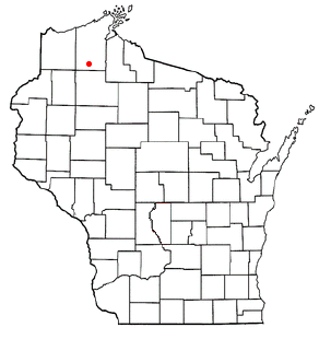
Cable is a town in Bayfield County, Wisconsin, United States. Its population was 825 at the 2010 U.S. census. The census-designated place of Cable and the unincorporated communities of Leonards and Radspur are located in the town.

Pulaski is a town in Iowa County, Wisconsin, United States. The population was 3,591 at the 2018 census.

<span class="mw-page-title-main">Weddington, North Carolina</span> Town in North Carolina, United States

Weddington is a suburban town in Union County, North Carolina, United States. The population was 9,459 at the 2010 census. It is a suburb in the Charlotte metropolitan area. The current mayor of Weddington is Jim Bell.

Winter is a town in Sawyer County, Wisconsin, United States. The population was 969 at the 2000 census. The Village of Winter is located within the town, but not a part of it. The unincorporated community of Hay Stack Corner is also located in the town. The town claims to be the largest town in Wisconsin.

<span class="mw-page-title-main">Townsend, Massachusetts</span> Town in Massachusetts, United States

Townsend is a town in Middlesex County, Massachusetts, United States. The population was 9,127 at the 2020 census.

References

  1. "ArcGIS REST Services Directory". United States Census Bureau. Retrieved September 20, 2022.
  2. 1 2 U.S. Geological Survey Geographic Names Information System: Middlesex, North Carolina
  3. 1 2 "U.S. Census website". United States Census Bureau . Retrieved January 31, 2008.
  4. "Census of Population and Housing". Census.gov. Retrieved June 4, 2015.