
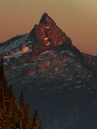
Mount Pugh is a peak near the western edge of the North Cascades, in Washington state. It is located 12.2 miles (19.6 km) west of Glacier Peak, one of the Cascade stratovolcanoes. It rises out of the confluence of the White Chuck River and the Sauk River, giving it very low footings. For example, it rises 6,150 feet (1,875 m) above the Sauk River Valley in just over 2 horizontal miles (3.2 km); its rise over the White Chuck River is almost as dramatic. The mountain is named for John Pugh, who settled nearby, in 1891.
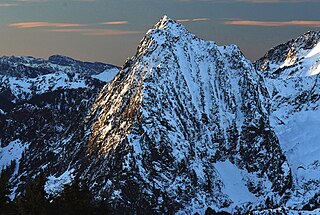
Sloan Peak is a 7,835-foot (2,388-metre) mountain in the North Cascades of Washington state. It rises about 40 miles (64 km) east of Everett, Washington and 12 miles southwest of Glacier Peak, one of the Cascade stratovolcanoes. It is located between the north and south forks of Sauk River, in the Mount Baker–Snoqualmie National Forest. The summit is situated about 4 miles (6.4 km) east of the Mountain Loop Highway.

Sahale Mountain is a jagged, glaciated mountain, in North Cascades National Park, in northern Washington state. The summit of Sahale Mountain is referred to as Sahale Peak. It is 0.3 miles (0.48 km) south of its higher neighbor, Boston Peak, and the saddle between the two is 80 feet (24 m) lower than Sahale's summit. Quien Sabe Glacier is to the west of the ridge between the two peaks while Davenport Glacier is in a cirque east of this ridge and above Horseshoe Basin. Sahale Glacier is south of the summit and east of Sahale Arm, a ridge that extends southwest from Sahale to Cascade Pass. The name Sahale may originate from a Northwest Native American word meaning "high place," "falcon," or "sacred."
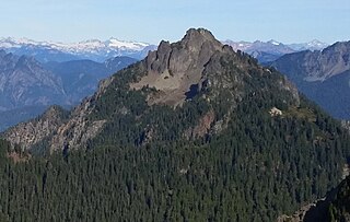
Breccia Peak is a mountain summit in the North Cascades, in Snohomish County of Washington state. Its summit is 6,487 feet (1,977 m) above sea level. The peak is the eroded remnant of a stratovolcano, and takes its name from the type of rock, breccia, that it is composed of. It is located 15 miles southeast of Darrington, Washington, and 8.7 miles (14.0 km) west of Glacier Peak, which is one of the Cascade stratovolcanoes. It is situated in the Glacier Peak Wilderness on land administered by the Mount Baker-Snoqualmie National Forest. The nearest higher peak is Mount Pugh, 3.5 miles (5.6 km) to the northwest. Precipitation runoff from Breccia Peak drains into tributaries of the Sauk River.

Del Campo Peak is a prominent summit near the western edge of the North Cascades, in Snohomish County of Washington state. It is located south of Barlow Pass along the Mountain Loop Highway near the Monte Cristo area. It is situated on land administered by the Mount Baker-Snoqualmie National Forest. The mountain is named for a mining claim on the mountain's slope. The nearest peak is Gothic Peak, 0.5 miles (0.80 km) to the southwest, and Foggy Pass is the low point between the two peaks. Foggy Lake lies in Gothic Basin below the south face of Del Campo Peak and collects precipitation runoff which ultimately drains to South Fork Sauk River via Weden Creek. Runoff from the west side of the mountain drains into the Sultan River, and the north side drains into headwaters of the Stillaguamish River. In terms of favorable weather, the best months for climbing are July through September.

Cadet Peak is a 7,186 ft mountain summit near the western edge of the North Cascades, in Snohomish County of Washington state. The peak is located southeast of Barlow Pass along the Mountain Loop Highway, and two miles east of the historic Monte Cristo area. It is situated within the Henry M. Jackson Wilderness, on land administered by the Mount Baker-Snoqualmie National Forest. The mountain was originally called Foggy Peak, for the Foggy Mine claim on the mountain's north slope, but the name was changed in 1896 to its present name, and the Foggy Peak name was transferred to the peak immediately northwest of Cadet. Back in the old mining days, the long sub-range stretching from Cadet Peak to Sheep Mountain was known as Pride of the Mountains Range. Cadet's nearest higher neighbor is Kyes Peak, 1.59 mi (2.56 km) to the south-southeast. Precipitation runoff from the mountain drains into tributaries of the Sauk River.

Mount Thomson is a prominent 6,554-foot-elevation (1,998-meter) mountain summit in eastern King County of Washington state.

White Mountain is a 7,043-foot (2,147-metre) mountain located in the Glacier Peak Wilderness of the North Cascades in Washington state. The mountain is situated on the crest of the Cascade Range, on the shared border of Snohomish County and Chelan County, and also straddling the boundary between Mount Baker-Snoqualmie National Forest and Wenatchee National Forest. White Mountain is located 3.04 mi (4.89 km) to the west-southwest of Kololo Peaks, and immediately north of White Pass. The Pacific Crest Trail traverses the south slope of the peak. Precipitation runoff from the peak drains into the White River, White Chuck River, and Sauk River. The mountain's name was suggested by The Mountaineers, and officially adopted in 1918 by the United States Board on Geographic Names.

Tupshin Peak is an 8,320+ ft mountain summit located in the Glacier Peak Wilderness of the North Cascades in Washington state. The mountain is situated in Chelan County, on land managed by Wenatchee National Forest. Its nearest higher peak is Devore Peak, 1.55 mi (2.49 km) to the south-southwest, and Bonanza Peak lies 6.71 mi (10.80 km) to the southwest. Precipitation runoff from the peak drains to nearby Lake Chelan via tributaries of the Stehekin River. The mountain's name comes from Chinook jargon and means "needle".

Johnson Mountain is a 6,721-foot (2,049-metre) mountain summit located in the Glacier Peak Wilderness of the North Cascades in Washington state. The mountain is situated in eastern Snohomish County, in the Mt. Baker-Snoqualmie National Forest. Its nearest higher peak is White Mountain, 3.3 mi (5.3 km) to the northeast, along with Indian Head Peak 3.38 mi (5.44 km) to the east. Precipitation runoff from the mountain drains into tributaries of the Sauk River. The mountain's name honors Mackinaw Johnson, a prospector who had a cabin in the vicinity.
Mount Forgotten is a 6,005-foot-elevation (1,830-meter) mountain summit near the western edge of the North Cascades, in Snohomish County of Washington state. It is located five miles north of Barlow Pass along the Mountain Loop Highway near the Monte Cristo area and is situated on land administered by the Mount Baker-Snoqualmie National Forest. The nearest higher peak is Mount Pugh, 4.22 mi (6.79 km) to the northeast. Precipitation runoff from the mountain drains into tributaries of the Sauk River.

Gothic Peak is a 6,213-foot (1,894-metre) multi-peak mountain summit located near the western edge of the North Cascades Range, in Snohomish County of Washington state. It is located south of Barlow Pass along the Mountain Loop Highway near the Monte Cristo area. It is situated on land administered by the Mount Baker-Snoqualmie National Forest. The mountain was named for early prospector William Gothic, who was one of the first to stake a claim in Gothic Basin. The mountain's name was officially adopted in 1967. The nearest higher peak is Del Campo Peak, 0.5 miles (0.80 km) to the northeast, and Foggy Pass is the low point between the two peaks. Foggy Lake lies in Gothic Basin below the east face of Gothic Peak and collects precipitation runoff which ultimately drains to South Fork Sauk River via Weden Creek. Runoff from the west side of the mountain drains into the Sultan River. The first ascent of the mountain was made on June 10, 1934, by Don Blair, Willard Carr, Norval Grigg, and Art Winder. In terms of catching favorable weather, the best months for climbing are July through September.
Sperry Peak is a 6,120+ ft mountain summit in Snohomish County of Washington state.
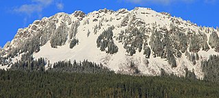
Sauk Mountain is a 5,541-foot (1,689-metre) mountain summit located in Skagit County of Washington state. It is situated immediately north of Rockport State Park and the North Cascades Highway, on land managed by the Mount Baker-Snoqualmie National Forest. Sauk Mountain is positioned west of the crest of the North Cascades Range, approximately nine miles east of Concrete, Washington, and 17 miles north of the town of Darrington. Its nearest higher peak is Helen Buttes, 5.86 miles (9.43 km) to the northeast. A popular two-mile trail provides hikers with good views from the craggy summit of Mount Baker, Mount Shuksan, Mount Chaval, and the Picket Range. Precipitation runoff from Sauk Mountain drains into tributaries of the Skagit River.

Emerald Peak is an 8,422-foot-elevation (2,567-meter) mountain summit located in the Chelan Mountains, in Chelan County of Washington state.

Saska Peak is an 8,404 ft (2,560 m) mountain summit located in the Chelan Mountains, in Chelan County of Washington state. The mountain is situated in Glacier Peak Wilderness of the North Cascades, on land managed by Wenatchee National Forest. Saska Peak ranks as the third-highest peak in the Chelan Mountains, and 74th-highest summit in Washington state. Its nearest higher neighbor is Emerald Peak, 0.66 mi (1.06 km) to the east-northeast, and Cardinal Peak is positioned 1.52 mi (2.45 km) to the east-southeast. These three highest peaks of the Chelan Mountains enclose the head of North Fork Entiat River valley. Precipitation runoff from the peak drains into the Entiat River drainage basin. The mountain's name honors Shil-how-Saskt, Tribal chief of the Entiat people, and was applied by Albert Hale Sylvester (1871-1944), a pioneer surveyor, topographer, and forest supervisor who named thousands of geographic features in the Cascades. In the Columbia-Moses language (Salishan), this name means "Standing in the middle of the sky."

Morning Star Peak is a 6,020 ft (1,830 m) mountain summit located near the western edge of the North Cascades, in Snohomish County of Washington state. It is situated 2.5 mi (4.0 km) southwest of Barlow Pass along the Mountain Loop Highway near the Monte Cristo area. It is set on land managed by Mount Baker-Snoqualmie National Forest. The nearest higher neighbor is Sperry Peak, 1 mile (1.6 km) to the northwest. Precipitation runoff from the south side of the mountain drains into the Sultan River, and the north side drains into headwaters of the Stillaguamish River. July through September offer the most favorable weather for climbing this mountain.

Black Mountain is a 7,262-foot-elevation (2,213-meter) summit located in the North Cascades, in Snohomish County of Washington state. The mountain is situated in the Glacier Peak Wilderness on land managed by Mount Baker-Snoqualmie National Forest. Neighbors include line parent Kololo Peaks, 6 mi (9.7 km) to the east, Painted Mountain two miles west, and Glacier Peak is 5 mi (8.0 km) to the northeast. Precipitation runoff from the peak drains west into tributaries of the North Fork Sauk River, and east into the White Chuck River. Topographic relief is significant as the summit rises 3,460 feet above the White Chuck in two miles. The first ascent of the summit was likely made in 1897 by a survey team including A. H. Dubor, Thomas G. Gerdine, and Sam Strom, who named the mountain for the dark color of its rock. The ascent from the north via Lake Byrne is non-technical.

Painted Mountain is a 6,975-foot-elevation (2,126-meter) summit located in the North Cascades, in Snohomish County of Washington state. The mountain is situated in the Glacier Peak Wilderness on land managed by Mount Baker-Snoqualmie National Forest. Neighbors include line parent Black Mountain, 2.2 mi (3.5 km) to the east, and Glacier Peak is 7 mi (11 km) to the northeast. Precipitation runoff from the peak drains west into tributaries of the North Fork Sauk River. Topographic relief is significant as the summit rises nearly 5,000 feet above the river in less than two miles.
Wilmans Peaks is a 6,880-foot elevation (2,097 m) mountain summit, in Snohomish County of Washington state.


