Glacier Peak

Last updated

Glacier Peak
Dakobed
Takobia
Glacier Peak 7118.JPG
East slope of Glacier Peak with Cool (left), Chocolate (descending from summit), North Guardian and Dusty Glaciers (right)
Highest point
Elevation 10,525+ ft (3,207+ m)  NAVD 88 [1]
Prominence 7,498 ft (2,285 m) [1]
Listing
Coordinates 48°06′43″N121°06′51″W / 48.11194°N 121.11417°W / 48.11194; -121.11417 [1] [2]
Geography
USA Washington relief location map.jpg
Red triangle with thick white border.svg
Glacier Peak
Washington
Location Snohomish County, Washington, U.S.
Parent range Cascade Range
Topo map USGS Glacier Peak East
Geology
Age of rock Pleistocene
Mountain type Stratovolcano [3]
Volcanic arc Cascade Volcanic Arc [3]
Last eruption 1700 [3]
Climbing
First ascent 1898 by Thomas Gerdine and party [4]
Easiest route Rock/ice climb on Sitkum Glacier

Glacier Peak or Dakobed (known in the Sauk-Suiattle dialect of the Lushootseed language as "Tda-ko-buh-ba" or "Takobia" [5] ) is the most isolated of the five major stratovolcanoes (composite volcanoes) of the Cascade Volcanic Arc in the U.S state of Washington. Located in the Glacier Peak Wilderness in Mount Baker–Snoqualmie National Forest, the volcano is visible from the west in Seattle, and from the north in the higher areas of eastern suburbs of Vancouver such as Coquitlam, New Westminster and Port Coquitlam. The volcano is the fourth tallest peak in Washington state, and not as much is known about it compared to other volcanoes in the area. Local Native Americans have recognized Glacier Peak and other Washington volcanoes in their histories and stories. When American explorers reached the region, they learned basic information about surrounding landforms, but did not initially understand that Glacier Peak was a volcano. Positioned in Snohomish County, the volcano is only 70 miles (110 km) northeast of downtown Seattle. From locations in northern Seattle and northward, Glacier Peak is closer than the more famous Mount Rainier (Tahoma), but as Glacier Peak is set farther into the Cascades and almost 4,000 feet (1,200 m) shorter, it is much less noticeable than Mount Rainier.

Contents

Glacier Peak is one of the most active of Washington's volcanoes. The volcano formed during the Pleistocene epoch, about one million years ago, and since the most recent ice age, it has produced some of the largest and most explosive eruptions in the state. When continental ice sheets retreated from the region, Glacier Peak began to erupt regularly, erupting explosively five times in the past 3,000 years. It has erupted repeatedly during at least six periods; two of these eruptions have been among the largest in Washington.

Geology

Remnants of past (prehistoric) lava domes are main components of the summit of the volcano, in addition to its false summit, Disappointment Peak. Past pyroclastic flow deposits are easily visible in river valleys near the volcano, likely caused by lava dome collapse, along with ridges found east of the summit consisting of ash cloud remains. [6] On its western flank, the volcano also has a lahar, or mudflow deposit, which runs for about 22 miles (35 km) into the White Chuck River Valley around 14,000 years ago. Ten other pyroclastic flow deposits are visible, all identified as relatively 10,000 years old. There is also a considerably newer mudflow, about 5,500 years old, which covers an area of 9.3 mi (15 km) between the same river valley, along with two small incidents both under 3,000 years old. Another lahar, of unidentified age, was rich in oxyhornblende dacite; and continued for 30 km (19 mi) into the Sauk River. [7]

There are also ash cloud deposits on the opposite eastern flank of the volcano. Studies of the mountain have to date been unable to find any correspondence with pyroclastic flows, but several past mudflows have been identified. In the Dusty Creek, located by the mountain, there is a lahar at least 98 ft (30 m) thick, containing pyroclastic flow deposits and other mudflows. However, this large mudflow is part of a 980-foot-thick (300 m) concentration of past incidents at the volcano that spans the Dusty and Chocolate Creek. In the area at least 2.4 cubic miles (10 km3) of lithic debris are contained. [7] Tephra deposits are for the most part constrained to the left flank of the volcano, and at least nine past incidents have been identified. These form several layers of tephra constructing the mountain. Smaller eruptions involving tephra occurred between 6,900 and 5,500 years ago, again between 3,450 and 200 years ago, and as recently as 316 to 90 years ago. [7]

On the mountain, about 5,900 ft (1,800 m) up, are three additional cinder conesone at the head of White Chuck River, one at Dishpan Gap, and one near Indian Pass. [8] The volcano has also created thermal features such as hot springs. There were three hot springs on the mountain: Gamma, Kennedy, and Sulphur, [3] but Kennedy Hot Springs was destroyed and buried in a slide. [9]

Tectonic setting

Diagram of plate tectonics for Cascade Range Cascade Range plate tectonics-en.svg
Diagram of plate tectonics for Cascade Range

The volcano is located in Washington, and is one of the five major stratovolcanoes there. Situated in the Cascade Volcanic Arc, the volcano was created by subduction of the oceanic Juan de Fuca Plate under the North American Plate. [10] Convergence between the two continues at a rate of 1.6 inches (4 cm) per year. This range has been volcanically active for about 36 million years, and the rocks that make up its volcanoes are between 55 and 42 million years old. Eruptions within the range are irregular and do not occur all at once. In an attempt to organize the volcanoes by age, scientists typically divide them into the High Cascades, younger volcanoes, and the Western Cascades, consisting of the older volcanoes. However, the vents in Washington are all of different ages so none of its volcanoes are included in either of the sections. [11]

History

Around the area, there were many Native Americans, and along with other Washington volcanoes, the mountain was recognized by them as a spirit. When European-American explorers reached the area, they learned about the mountain, though only partially, through local legends. Although the local people described Glacier Peak as a vital part of their storytelling and beliefs; when other volcanoes in the area were mapped, Glacier Peak was left out. In 1850 natives mentioned the volcano to naturalist George Gibbs saying that the volcano had once "smoked". [6] In 1898 the volcano was finally documented on a map. [6]

Native Americans also used the area around the Cascades for their agriculture, leading them to often congregate in the region. As a result, gold miners eventually reached the area in the 1870s–1890s, searching for resources and rich land. The first white man recorded to observe the mountain—Daniel Lindsley—was an employee of the Northern Pacific Railroad Company searching for possible railroad routes when he saw it in 1870. [12]

Eruptive history

Despite its elevation of 10,541 feet (3,213 m), Glacier Peak is a small stratovolcano. Its relatively high summit is a consequence of its location atop a high ridge, but its volcanic portion extends only 1,600–3,200 feet (500–1,000 m) above the underlying ridge. [13] Another Cascade Arc volcano with similar geomorphology is the Mount Meager massif in southwestern British Columbia, Canada, which is situated on a 1,300 ft (400 m) ridge of nonvolcanic, crystalline and metamorphic rock. [14]

View from Liberty Cap across the Suiattle River Valley Glacier Peak 7137b.jpg
View from Liberty Cap across the Suiattle River Valley

Of the five major volcanoes in Washington, only Glacier Peak and Mount St. Helens have had large eruptions in the past 15,000 years. Since both volcanoes generate magma of dacitic origin, the viscous magma builds up since it cannot flow through the eruptive vent. Gradually, the pressure grows, culminating in an explosion that ejects materials such as tephra, which in its simplest form, is ash. [6]

Tephrochronology and radiocarbon dating indicate that Glacier Peak eruptions occurred in 1700 AD ± 100 years, 1300 AD ± 300 years, 900 AD ± 50 years, 200 AD ± 50 years, 850 BC, 3150 BC, and in 3550 BC. The Volcanic Explosivity Index (VEI) for three of these was 2 to 4, small compared to the 5 of the 1980 eruption of Mount St. Helens. They were characterized mainly by a central vent eruption, followed by an explosive eruption. These eruptions varied in outcome; some produced lahars, some pyroclastic flows, and others lava domes. [3]

A little more than 13,000 years ago, a sequence of nine tephra eruptions occurred within a period of less than a few hundred years. Associated with these eruptions were pyroclastic flows. Mixed with snow, ice and water, these formed lahars that raced into three nearby rivers, filling their valleys with deep deposits. Subsequently, the mudflows drained into both the North Fork of the Stillaguamish River (at that time an outlet of the Sauk River) and Skagit Rivers. In Arlington, 60 miles (97 km) downstream, lahars deposited seven feet of sediment. Subsequent erosion of lahar deposits near Darrington led to the current river system with the Stillaguamish River separated from the Sauk/Skagit Rivers. Lahar debris was deposited along both the Skagit and Stillaguamish Rivers all the way to Puget Sound. A small portion of the erupted tephra was deposited locally. However, most of the tephra reached higher levels of the atmosphere, and was transported by the wind hundreds of miles. Deposits from this congregation were as thick as 1 foot (0.30 m) near Chelan and 0.3 inches (7.6 mm) near Missoula, Montana. [6] The table below shows the three largest eruptions from this sequence. [15]

Plinian Eruptions ~13,000 Years Ago
Unit Name DRE Volume Bulk Deposit VolumePlume Height
Layer B2.1 km3 (0.50 cu mi)6.5 km3 (1.6 cu mi)31 km (19 mi)
Layer M0.4 km3 (0.096 cu mi)1.1 km3 (0.26 cu mi)N/A
Layer G1.9 km3 (0.46 cu mi)6.0 km3 (1.4 cu mi)32 km (20 mi)

Since these events, Glacier Peak has produced several lahars. The largest mudflows were 5,900 and 1,800 years ago and were associated with dome-building eruptions. In both cases, the lahars traveled down the Skagit River to Puget Sound. [6]

Hazards

Glacier Peak from the southeast Glacier Peak.jpg
Glacier Peak from the southeast

The risk of an eruption in any given year is currently estimated as 1 in 1,000. [16] As of 2018, Glacier Peak is classified as one of the 18 most dangerous volcanoes in the United States. [17]

When lahars reach populated areas, they can bury structures and people. An example was the Armero tragedy at Nevado del Ruiz where 23,000 died from an enormous mudflow. Lahars from Glacier Peak pose a similar threat to the small communities of Darrington, Arlington, and Concrete with a lesser threat to the larger and rapidly growing towns of Mount Vernon and Burlington, as well as other communities along the lower Skagit and Stillaguamish Rivers. [6] A 2005 study conducted by the United States Geological Survey identified nine Cascade volcanoes, including Glacier Peak, as "very-high-threat volcanoes with inadequate monitoring". At the time of the study, only one seismometer was installed on Glacier Peak that had not "worked in two years". [18] As of 2023, the PNSN still operates only one seismometer on Glacier Peak. [19]

In 2018, the USGS applied to add four more stations, but regulations protecting federal wilderness areas prohibit the use of helicopters that are needed to transport materials; advocacy groups opposed an exemption for the project and filed objections. [20] [21] In 2019, Congress passed the National Volcano Early Warning and Monitoring System Act to authorize more monitoring stations, but did not include funding to construct them. [22] Permits were granted by the U.S. Forest Service in June 2022. [23]

Climate

Climate data for Glacier Peak Summit. 1991-2020
MonthJanFebMarAprMayJunJulAugSepOctNovDecYear
Mean daily maximum °F (°C)21.1
(−6.1)
20.5
(−6.4)
21.8
(−5.7)
26.2
(−3.2)
35.0
(1.7)
41.3
(5.2)
51.4
(10.8)
51.9
(11.1)
46.4
(8.0)
35.8
(2.1)
24.2
(−4.3)
19.6
(−6.9)
32.9
(0.5)
Daily mean °F (°C)16.0
(−8.9)
14.0
(−10.0)
14.1
(−9.9)
17.2
(−8.2)
25.1
(−3.8)
30.8
(−0.7)
39.4
(4.1)
40.1
(4.5)
35.3
(1.8)
26.8
(−2.9)
18.5
(−7.5)
14.8
(−9.6)
24.3
(−4.3)
Mean daily minimum °F (°C)10.8
(−11.8)
7.5
(−13.6)
6.4
(−14.2)
8.3
(−13.2)
15.2
(−9.3)
20.2
(−6.6)
27.4
(−2.6)
28.2
(−2.1)
24.2
(−4.3)
17.8
(−7.9)
12.9
(−10.6)
9.9
(−12.3)
15.7
(−9.1)
Average precipitation inches (mm)13.78
(350)
10.65
(271)
11.26
(286)
6.59
(167)
4.33
(110)
3.33
(85)
1.83
(46)
2.27
(58)
4.06
(103)
11.31
(287)
16.43
(417)
16.18
(411)
102.02
(2,591)
Average dew point °F (°C)8.6
(−13.0)
5.3
(−14.8)
4.1
(−15.5)
4.5
(−15.3)
10.7
(−11.8)
15.8
(−9.0)
19.4
(−7.0)
19.2
(−7.1)
16.0
(−8.9)
13.1
(−10.5)
10.3
(−12.1)
8.4
(−13.1)
11.3
(−11.5)
Source: PRISM Climate Group [24]

Glaciers

View of the northeast face from Image Lake N2 Glacier Peak.jpg
View of the northeast face from Image Lake

Eleven significant glaciers cover Glacier Peak. When C.E. Rusk first saw these glaciers in 1906 they were beginning to retreat, but were still very advanced. The average retreat of Glacier Peak glaciers from the Little Ice Age to the 1958 positions was 5,381 feet (1,640 m). Richard Hubley noted that North Cascade glaciers began to advance in the early 1950s, after 30 years of rapid retreat. The advance was in response to a sharp rise in winter precipitation and a decline in summer temperature beginning in 1944. Ten of the fifteen glaciers around Glacier Peak advanced, including all of the glaciers directly on the mountain's slopes. Advances of Glacier Peak glaciers ranged from 50 to 1,575 feet (15 to 480 m) and culminated in 1978. All eleven Glacier Peak glaciers that advanced during the 1950–79 period emplaced identifiable maximum advance terminal moraines. From 1984 to 2005, the average retreat of eight Glacier Peak glaciers from their recent maximum positions was 1,017 feet (310 m). Milk Lake Glacier, on the north flank of the mountain, melted away altogether in the 1990s. [25]

Recreation

The Pacific Crest Trail passes near Glacier Peak. The Suiattle River crossing is a well-known feature on the Pacific Crest Trail (PCT) as it passes through the area. The Suiattle PCT crossing used to have a bridge crossing until it was flooded out by storms in late 2003. [26]

The first recorded person to climb the mountain was Thomas Gerdine, along with a group of United States Geological Survey scientists, Sam Strom, A. H. Dubor, and Darcy Bard, in 1897. [4] The climb is Alpine Grade I or II. [27]

The easiest ski route is about 5 miles (8.0 km) of walking along the White Chuck River Trail (Forest Service Trail No. 643) and up the Sitkum Glacier. The trail is reached via Forest Service Road No. 23. The Sitkum Glacier ski route is rated blue to black diamond for both the ascent and the descent. [28]

Cultural references

The Seattle-based composer, Alan Hovhaness, dedicated his Symphony no.66 as "Hymn to Glacier Peak": see Symphony no.66 (Hovhaness).

The non-fiction book Encounters with the Archdruid by John McPhee, which portrays the environmental advocacy of David Brower, devotes the first of its three main sections to a conflict over mineral prospecting around Glacier Peak.

See also

Related Research Articles

<span class="mw-page-title-main">Mount Baker</span> Mountain in Washington state, United States

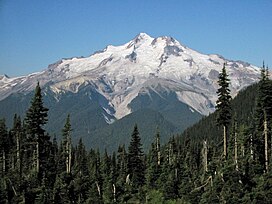
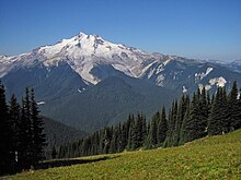
Mount Baker, also known as Koma Kulshan or simply Kulshan, is a 10,781 ft (3,286 m) active glacier-covered andesitic stratovolcano in the Cascade Volcanic Arc and the North Cascades of Washington in the United States. Mount Baker has the second-most thermally active crater in the Cascade Range after Mount St. Helens. About 30 miles (48 km) due east of the city of Bellingham, Whatcom County, Mount Baker is the youngest volcano in the Mount Baker volcanic field. While volcanism has persisted here for some 1.5 million years, the current volcanic cone is likely no more than 140,000 years old, and possibly no older than 80–90,000 years. Older volcanic edifices have mostly eroded away due to glaciation.

<span class="mw-page-title-main">Mount St. Helens</span> Volcano in Washington, U.S.

Mount St. Helens is an active stratovolcano located in Skamania County, Washington, in the Pacific Northwest region of the United States. It lies 52 miles (83 km) northeast of Portland, Oregon, and 98 miles (158 km) south of Seattle. Mount St. Helens takes its English name from that of the British diplomat Alleyne Fitzherbert, 1st Baron St Helens, a friend of explorer George Vancouver who surveyed the area in the late 18th century. The volcano is part of the Cascade Volcanic Arc, a segment of the Pacific Ring of Fire.

<span class="mw-page-title-main">Mount Bachelor</span> Dormant stratovolcano in Oregon, United States

Mount Bachelor, formerly named Bachelor Butte, is a dormant stratovolcano atop a shield volcano in the Cascade Volcanic Arc and the Cascade Range of central Oregon. Named Mount Bachelor because it stands apart from the nearby Three Sisters, it lies in the eastern segment of the central portion of the High Cascades, the eastern segment of the Cascade Range. The volcano lies at the northern end of the 15-mile (24 km) long Mount Bachelor Volcanic Chain, which underwent four major eruptive episodes during the Pleistocene and the Holocene. The United States Geological Survey considers Mount Bachelor a moderate threat, but Bachelor poses little threat of becoming an active volcano in the near future. It remains unclear whether the volcano is extinct or just inactive.

<span class="mw-page-title-main">Lahar</span> Violent type of mudflow or debris flow from a volcano

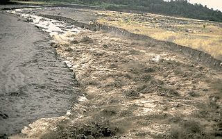
A lahar is a violent type of mudflow or debris flow composed of a slurry of pyroclastic material, rocky debris and water. The material flows down from a volcano, typically along a river valley.

<span class="mw-page-title-main">Nevado del Ruiz</span> Volcanic mountain in Colombia

Nevado del Ruiz, also known as La Mesa de Herveo is a volcano on the border of the departments of Caldas and Tolima in Colombia, about 129 km (80 mi) west of the capital city Bogotá. It is a stratovolcano composed of many layers of lava alternating with hardened volcanic ash and other pyroclastic rocks. Volcanic activity at Nevado del Ruiz began about two million years ago, during the Early Pleistocene or Late Pliocene, with three major eruptive periods. The current volcanic cone formed during the present eruptive period, which began 150,000 years ago.

<span class="mw-page-title-main">Geology of the Lassen volcanic area</span> Geology of a U.S. national park in California

The Lassen volcanic area presents a geological record of sedimentation and volcanic activity in and around Lassen Volcanic National Park in Northern California, U.S. The park is located in the southernmost part of the Cascade Mountain Range in the Pacific Northwest region of the United States. Pacific Oceanic tectonic plates have plunged below the North American Plate in this part of North America for hundreds of millions of years. Heat and molten rock from these subducting plates has fed scores of volcanoes in California, Oregon, Washington and British Columbia over at least the past 30 million years, including these in the Lassen volcanic areas.

<span class="mw-page-title-main">Lassen Peak</span> Active volcano in California, United States

Lassen Peak, commonly referred to as Mount Lassen, is a lava dome volcano and the southernmost active volcano in the Cascade Range of the Western United States. Located in the Shasta Cascade region of Northern California, it is part of the Cascade Volcanic Arc, which stretches from southwestern British Columbia to northern California. Lassen Peak reaches an elevation of 10,457 ft (3,187 m), standing above the northern Sacramento Valley. It supports many flora and fauna among its diverse habitats, which are subject to frequent snowfall and reach high elevations.

<span class="mw-page-title-main">Mount Jefferson (Oregon)</span> Stratovolcano in the Cascade Range, Oregon, US

Mount Jefferson is a stratovolcano in the Cascade Volcanic Arc, part of the Cascade Range in the U.S. state of Oregon. The second highest mountain in Oregon, it is situated within Linn County, Jefferson County, and Marion County and forms part of the Mount Jefferson Wilderness. Due to the ruggedness of its surroundings, the mountain is one of the hardest volcanoes to reach in the Cascades. It is also a popular tourist destination despite its remoteness, with recreational activities including hiking, backpacking, mountaineering, and photography. Vegetation at Mount Jefferson is dominated by Douglas fir, silver fir, mountain hemlock, ponderosa pine, lodgepole pine, and several cedar species. Carnivores, insectivores, bats, rodents, deer, birds, and various other species inhabit the area.

<span class="mw-page-title-main">Mount Thielsen</span> Extinct shield volcano in Oregon

Mount Thielsen, or Big Cowhorn, is an extinct shield volcano in the Oregon High Cascades, near Mount Bailey. Because eruptive activity ceased 250,000 years ago, glaciers have heavily eroded the volcano's structure, creating precipitous slopes and a horn-like peak. The spire-like shape of Thielsen attracts lightning strikes and creates fulgurite, an unusual mineral. The prominent horn forms a centerpiece for the Mount Thielsen Wilderness, a reserve for recreational activities such as skiing and hiking. Thielson is one of Oregon's Matterhorns.

<span class="mw-page-title-main">Mount Mazama</span> Complex volcano in the Cascade Range

Mount Mazama is a complex volcano in the western U.S. state of Oregon, in a segment of the Cascade Volcanic Arc and Cascade Range. Most of the mountain collapsed following a major eruption approximately 7,700 years ago. The volcano is in Klamath County, in the southern Cascades, 60 miles (97 km) north of the Oregon–California border. Its collapse, due to the eruption of magma emptying the underlying magma chamber, formed a caldera that holds Crater Lake. Mount Mazama originally had an elevation of 12,000 feet (3,700 m), but following its climactic eruption this was reduced to 8,157 feet (2,486 m). Crater Lake is 1,943 feet (592 m) deep, the deepest freshwater body in the U.S. and the second deepest in North America after Great Slave Lake in Canada.

<span class="mw-page-title-main">Three Fingered Jack</span> Mountain in United States of America

Three Fingered Jack is a summit of a shield volcano of the Cascade Range in the U.S. state of Oregon. Formed during the Pleistocene epoch, the mountain consists mainly of basaltic andesite lava and was heavily glaciated in the past. While other Oregon volcanoes that were heavily glaciated—such as Mount Washington and Mount Thielsen—display eroded volcanic necks, Three Fingered Jack's present summit is a comparatively narrow ridge of loose tephra supported by a dike only 10 feet (3.0 m) thick on a generally north–south axis. Glaciation exposed radiating dikes and plugs that support this summit. The volcano has long been inactive and is highly eroded.

<span class="mw-page-title-main">Belknap Crater</span> Shield volcano in the U.S. state of Oregon

Belknap Crater is a shield volcano in the Cascade Range in the U.S. state of Oregon. Located in Linn County, it is associated with lava fields and numerous subfeatures including the Little Belknap and South Belknap volcanic cones. It lies north of McKenzie Pass and forms part of the Mount Washington Wilderness. Belknap is not forested and most of its lava flows are not vegetated, though there is some wildlife in the area around the volcano, as well as a number of tree molds formed by its eruptive activity.

<span class="mw-page-title-main">Spirit Lake (Washington)</span> Lake in Skamania County, Washington, U.S.

Spirit Lake is a lake in Skamania County, Washington, United States, located north of Mount St. Helens. It was a popular tourist destination for many years until Mount St. Helens erupted in 1980. Previously there had been six camps on the shore of Spirit Lake: Boy Scout, the Girl Scout Camp at Spirit Lake, two YMCA camps, Harmony Fall Lodge, and another for the general public. There were also several lodges accessible to visitors, including Spirit Lake Lodge and Mt. St. Helens Lodge. The latter was owned and operated by Harry R. Truman, a noted victim of the volcano's 1980 eruption.

<span class="mw-page-title-main">Skagit River</span> River in Canada and the United States

The Skagit River is a river in southwestern British Columbia in Canada and northwestern Washington in the United States, approximately 150 mi (240 km) long. The river and its tributaries drain an area of 1.7 million acres (690,000 hectares) of the Cascade Range along the northern end of Puget Sound and flows into the sound.

<span class="mw-page-title-main">Sauk River (Washington)</span> River in Washington

The Sauk River is a tributary of the Skagit River, approximately 45 miles (72 km) long, in northwestern Washington in the United States. It drains an area of the high Cascade Range in the watershed of Puget Sound north of Seattle. The river is a popular destination for fly fishing. It is a National Wild and Scenic River.

<span class="mw-page-title-main">Broken Top</span> Glacially eroded stratovolcano in the US State of Oregon

Broken Top is a glacially eroded complex stratovolcano. It lies in the Cascade Volcanic Arc, part of the extensive Cascade Range in the U.S. state of Oregon. Located southeast of the Three Sisters peaks, the volcano, residing within the Three Sisters Wilderness, is 20 miles (32 km) west of Bend, Oregon in Deschutes County. Eruptive activity stopped roughly 100,000 years ago, and erosion by glaciers has since reduced the volcano's cone to where its contents are exposed. There are two named glaciers on the peak, Bend and Crook Glacier.

<span class="mw-page-title-main">Mount Meager massif</span> Group of volcanoes in British Columbia, Canada

The Mount Meager massif is a group of volcanic peaks in the Pacific Ranges of the Coast Mountains in southwestern British Columbia, Canada. Part of the Cascade Volcanic Arc of western North America, it is located 150 km (93 mi) north of Vancouver at the northern end of the Pemberton Valley and reaches a maximum elevation of 2,680 m (8,790 ft). The massif is capped by several eroded volcanic edifices, including lava domes, volcanic plugs and overlapping piles of lava flows; these form at least six major summits including Mount Meager which is the second highest of the massif.

<span class="mw-page-title-main">Cascade Volcanoes</span> Chain of stratovolcanoes in western North America

The Cascade Volcanoes are a number of volcanoes in a volcanic arc in western North America, extending from southwestern British Columbia through Washington and Oregon to Northern California, a distance of well over 700 miles (1,100 km). The arc formed due to subduction along the Cascadia subduction zone. Although taking its name from the Cascade Range, this term is a geologic grouping rather than a geographic one, and the Cascade Volcanoes extend north into the Coast Mountains, past the Fraser River which is the northward limit of the Cascade Range proper.

<span class="mw-page-title-main">Mount Rainier</span> Stratovolcano in the U.S. state of Washington

Mount Rainier, also known as Tahoma, is a large active stratovolcano in the Cascade Range of the Pacific Northwest in the United States. The mountain is located in Mount Rainier National Park about 59 miles (95 km) south-southeast of Seattle. With a summit elevation of 14,411 ft (4,392 m), it is the highest mountain in the U.S. state of Washington, the most topographically prominent mountain in the contiguous United States, and the tallest in the Cascade Volcanic Arc.

<span class="mw-page-title-main">Mount Gareloi</span> Stratovolcano in the Aleutian Islands of Alaska, U.S.

Mount Gareloi, or Gareloi Volcano, is a stratovolcano in the Aleutian Islands of Alaska, United States, about 1,259 miles (2,026 km) from Anchorage. Gareloi is located on Gareloi Island, and comprises most of its land mass. The island also has two small glaciers which protrude to the northwest and southeast.

References

  1. 1 2 3 "Glacier Peak, Washington". Peakbagger.com. Retrieved October 17, 2012.
  2. "Glacier Peak". NGS Data Sheet. National Geodetic Survey, National Oceanic and Atmospheric Administration, United States Department of Commerce . Retrieved December 20, 2008.
  3. 1 2 3 4 5 "Glacier Peak". Global Volcanism Program . Smithsonian Institution . Retrieved January 8, 2009.
  4. 1 2 Beckey, Fred (2003). Cascade Alpine Guide: Climbing and High Routes. Vol. Stevens Pass to Rainy Pass (3rd ed.). Seattle, Washington: Mountaineers Books. pp. 100–110. ISBN   0-89886-838-6. Archived from the original on February 25, 2024. Retrieved February 21, 2017.
  5. Bedal Fish, Jean; Bedal, Edith (2000). Two Voices – A History of the Sauk and Suiattle People, and Sauk Country Experiences. Astriba R. Blukis Onat.
  6. 1 2 3 4 5 6 7 Mastin and Waitt (2000). Glacier Peak History and Hazards of a Cascade Volcano: USGS Fact Sheet 058-00. United States Geological Survey. Archived from the original on July 28, 2013. Retrieved January 11, 2009.
  7. 1 2 3 Beget, James E. (1982). Postglacial volcanic deposits at Glacier Peak, Washington, and potential hazards from future eruptions. Denver, CO: U.S. Geological Survey. OCLC   8911553.
  8. Tabor, R.W.; Crowther, D.F. (1994). "On Bathliths and Volcanoes – Intrusion and Eruption of Late Cenozoic Magmas in the Glacier Peak Area North Cascades, Washington". Geological Survey Professional Paper (604). Washington, D.C.: United States Geological Survey: 1083 v. hdl:2027/uc1.31822023316870. ISSN   0096-0446. OCLC   679317055. Archived from the original on February 25, 2024. Retrieved May 5, 2023.
  9. "USDA Forest Service: Kennedy Ridge Trail #639". Archived from the original on October 18, 2014. Retrieved November 23, 2011.
  10. Brantley (1994). Volcanoes of the United States: USGS General Interest Publication. United States Geological Survey.
  11. Swanson; et al. (1989). Cenozoic Volcanism in the Cascade Range and Columbia Plateau, Southern Washington and Northernmost Oregon: AGU Field Trip Guidebook T106. United States Geological Survey.
  12. "Description: Glacier Peak Volcano, Washington". United States Geological Survey. July 21, 2002. Archived from the original on February 25, 2013. Retrieved January 12, 2009.
  13. Charles Arthur Wood; Juergen Kienle, eds. (1990). Volcanoes of North America - United States and Canada. Cambridge University Press. pp. 156–158. ISBN   978-0-521-43811-7.
  14. "Garabaldi volcano belt: Mount Meager volcanic field". Catalogue of Canadian volcanoes. Natural Resources Canada. April 1, 2009. Archived from the original on June 6, 2009. Retrieved October 22, 2011.
  15. Gardner, J; Carey, S; Sigurdsson, H (February 1, 1998). "Plinian eruptions at Glacier Peak and Newberry volcanoes, United States: Implications for volcanic hazards in the Cascade Range". Geological Society of America Bulletin. 110 (2): 173–187. Bibcode:1998GSAB..110..173G. doi:10.1130/0016-7606(1998)110<0173:PEAGPA>2.3.CO;2.
  16. USGS: Volcano Hazards Program. "CVO Glacier Peak". volcanoes.usgs.gov. Archived from the original on February 21, 2017. Retrieved December 26, 2017.
  17. "The most dangerous volcanoes in the U.S., according to the government". Science. October 26, 2018. Archived from the original on March 3, 2021. Retrieved September 14, 2023.
  18. Tom Paulson (May 18, 2005). "Mount St. Helens still shrouded in secrets". Seattle Post-Intelligencer . Retrieved January 12, 2009.
  19. "Volcano Seismicity: Glacier Peak". Pacific Northwest Seismic Network. Archived from the original on February 15, 2023. Retrieved September 14, 2023.
  20. Bray, Kari (August 17, 2018). "Will seismometers be in place before our volcano erupts?". The Everett Herald. Archived from the original on November 28, 2023. Retrieved September 14, 2023.
  21. Spitzer, Gabriel; Kwong, Emily; McCoy, Berly (August 19, 2022). "Transcript: Eavesdropping On A Volcano". Short Wave. NPR. Archived from the original on September 14, 2023. Retrieved September 14, 2023.
  22. Hall, Shannon (September 9, 2019). "We're Barely Listening to the U.S.'s Most Dangerous Volcanoes". The New York Times. ISSN   0362-4331. Archived from the original on June 24, 2023. Retrieved September 14, 2023.
  23. Bryan, Zachariah (July 6, 2022). "Forest Service green-lights new seismometers at remote Glacier Peak". The Everett Herald. Archived from the original on November 28, 2023. Retrieved September 14, 2023.
  24. "PRISM Climate Group, Oregon State University". www.prism.oregonstate.edu. Archived from the original on July 25, 2019. Retrieved January 12, 2022.
  25. Pelto, Mauri S. "North Cascade Glacier Climate Project". Nichols College. Archived from the original on October 13, 1999. Retrieved June 6, 2006.
  26. Karen Sykes (February 22, 2007). "Hike Of The Week: Flood damage makes area lonelier than ever". Seattle Post-Intelligencer . Retrieved January 15, 2009.
  27. "Skikum Glacier". Summit Post. Archived from the original on July 8, 2022. Retrieved July 8, 2022.
  28. Amar Andalkar (April 25, 2005). "Glacier Peak". Archived from the original on July 16, 2013. Retrieved January 28, 2009.