
The Kenai Peninsula is a large peninsula jutting from the coast of Southcentral Alaska. The name Kenai is derived from the word "Kenaitze" or "Kenaitze Indian Tribe", the name of the Native Athabascan Alaskan tribe, the Kahtnuht’ana Dena’ina, who historically inhabited the area. They called the Kenai Peninsula Yaghanen.

Kenai Fjords National Park is a national park of the United States that comprises the Harding Icefield, its outflowing glaciers, and coastal fjords and islands. The park covers an area of 669,984 acres on the Kenai Peninsula in south-central Alaska, west of the town of Seward.

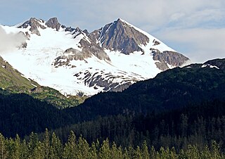
The Kenai Mountains are a mountain range in the U.S. state of Alaska. They extend 192 km (120 mi) northeast from the southern end of the Kenai Peninsula to the Chugach Mountains, and have an average elevation of 3,000 to 5,000 feet.

An ice field is a mass of interconnected valley glaciers on a mountain mass with protruding rock ridges or summits. They are often found in the colder climates and higher altitudes of the world where there is sufficient precipitation for them to form. The higher peaks of the underlying mountain rock that protrude through the icefields are known as nunataks. Ice fields are larger than alpine glaciers, but smaller than ice caps and ice sheets. The topography of ice fields is determined by the shape of the surrounding landforms, while ice caps have their own forms overriding underlying shapes.

The Tustumena Glacier is a glacier located on the Kenai Peninsula of Alaska. The Tustumena Glacier begins in the Harding Icefield and makes its way down west for about 20 miles (32 km) until its terminus roughly 5 miles (8.0 km) before Tustumena Lake. The glacier is retreating due to global warming.
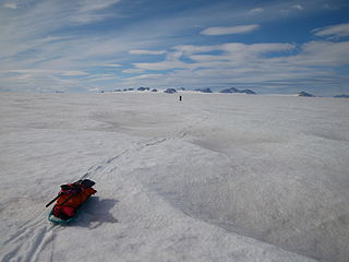
The Harding Icefield is an expansive icefield located in the Kenai Mountains of the Kenai Peninsula in Alaska. It is also partially located in Kenai Fjords National Park. It is named for U.S. President Warren G. Harding.

Exit Glacier is a glacier derived from the Harding Icefield in the Kenai Mountains of Alaska and one of Kenai Fjords National Park's major attractions. It is one of the most accessible valley glaciers in Alaska and is a visible indicator of glacial recession due to climate change. Exit Glacier retreated approximately 187 feet (57 m) from 2013 to 2014 and park scientists continue to monitor and record the glacier's accelerating recession.
The McCarty Glacier is a tidewater glacier located in the Harding Icefield in the Kenai Mountains of the Kenai Peninsula, Alaska.

The Aialik Glacier is a glacier in the Kenai Peninsula Borough of Alaska. It drains into Aialik Bay. Part of Kenai Fjords National Park, it drains the Harding Icefield. Aialik Glacier, a little over 15 miles from Seward, is the largest glacier in Aialik Bay, located in Kenai Fjords National Park. While fairly stable, the glacier calves most actively in May and June.

Mount Alice is a 5,318-foot (1,621 m) mountain summit in the U.S. state of Alaska.

Carpathian Peak is a prominent 6,000+ ft mountain summit located in the Kenai Mountains, in the U.S. state of Alaska. The peak is situated in Chugach National Forest, 8 mi (13 km) southwest of Whittier, Alaska, at the isthmus of the Kenai Peninsula, where the Kenai Mountains meet the Chugach Mountains. Although modest in elevation, relief is significant since the eastern aspect of the mountain rises from sea level at Blackstone Bay in Prince William Sound. The peak's nearest higher peak is Isthmus Peak, 8 mi (13 km) to the south, and nearby Bard Peak lies 5 mi (8.0 km) northeast. The mountain's name was officially adopted in 1959 by the United States Geological Survey. The 1959 first ascent party of Keith Hart, Ted Barrett, and Mat Nitsch suggested the name as a tribute to the Carpathian Mountains back in Mat's homeland which at the time was behind the Iron Curtain, with the intention to create a symbol of freedom.

Mount Ascension is a prominent 5,710-foot (1,740 m) mountain summit located in the Kenai Mountains, on the Kenai Peninsula, in the U.S. state of Alaska. The mountain is situated in Chugach National Forest, 6.8 mi (11 km) south of Mount Adair, 3.5 mi (6 km) north of Resurrection Peaks, and 10 mi (16 km) north of Seward, Alaska. The peak is near the mouth of Resurrection River into Resurrection Bay. The name Resurrection, referring to the Resurrection of Jesus, is overused for nearby landforms on the Kenai peninsula, as the mountain to the immediate south is Resurrection Peaks. This Ascension name is a variation of the theme. Mount Ascension's name was proposed in 1968 by the Mountaineering Club of Alaska, and officially adopted in 1969 by the United States Geological Survey. Access to the peak is via the Lost Lake Trail, and mountaineering skills are needed to reach the summit. In clear weather the immense Harding Icefield can be seen from the top. The first ascent of this peak was made October 6, 1968, by John Vincent Hoeman and his wife, Dr. Grace (Jansen) Hoeman.
Phoenix Peak is a 5,187-foot (1,581 m) mountain summit located in the Kenai Mountains, on the Kenai Peninsula, in the U.S. state of Alaska. The peak is situated in Kenai Fjords National Park, 2 mi (3 km) southwest of Mount Benson, 1.1 mi (2 km) northwest of Marathon Mountain, and 3.5 mi (6 km) west of Seward, Alaska. Precipitation runoff from the mountain and meltwater from its glaciers drains into tributaries of the Resurrection River. The first ascent of the peak was made July 23, 1964, by Don Stockard of the Mountaineering Club of Alaska. The peak was named in 1965 by the Mountaineering Club of Alaska for the first ship ever built in Russian America, the Phoenix, which was constructed in 1794 by Russians in nearby Resurrection Bay. The mountain's toponym was officially adopted in 1966 by the United States Geological Survey.

Bear Mountain is a 4,019-foot (1,225 m) mountain summit located in the Kenai Mountains, on the Kenai Peninsula, in the U.S. state of Alaska. The peak is situated in Chugach National Forest, 5 mi (8 km) northeast of Bear Glacier, 2.1 mi (3 km) south-southeast of Marathon Mountain, and 5 mi (8 km) southwest of Seward, Alaska. The peak's local name was reported in 1951 by the U.S. Geological Survey. The months May and June offer the most favorable weather for viewing the mountain. In fair weather, the Harding Icefield can be seen from the summit.

Lowell Peak is a 4,416-foot (1,346 m) mountain summit located in the Kenai Mountains, on the Kenai Peninsula, in the U.S. state of Alaska. The peak is situated in Chugach National Forest, 1.2 mi (2 km) northwest of Bear Mountain, 1.5 mi (2 km) south-southwest of Marathon Mountain, 2.2 mi (4 km) south of Phoenix Peak, and 3 mi (5 km) west-southwest of Seward, Alaska. The months May and June offer the most favorable weather for viewing the mountain. In fair weather, the Harding Icefield can be seen from the summit, as well as Mount Alice on the opposite side of Resurrection Bay. This unofficially named peak takes its name from Franklin G. Lowell and his family who were the first homesteaders to settle the Seward area in 1883.

Nugget Towers is a mountain ridge with a series of peaks, two primarily, the highest of which is 5,378-ft elevation, and located on the southern periphery of the Juneau Icefield, in the Boundary Ranges of southeast Alaska. These peaks are situated east of Mendenhall Glacier, 10 mi (16 km) north of Juneau, and 1.9 mi (3 km) northeast of Bullard Mountain, on land managed by Tongass National Forest. Stroller White Mountain lies 4.5 mi (7 km) west-northwest on the opposite side of the glacier, and Heintzleman Ridge lies 3 mi (5 km) to the south. Although modest in elevation, relief is significant since the mountain rises 3,500 feet above Nugget Creek's upper basin in less than one mile. Precipitation runoff from the mountain drains into Mendenhall Lake via Nugget Creek and Nugget Falls. This geographic feature's local name was reported in 1965 by U.S. Geological Survey.

Pacific Coastal Mountain icefields and tundra is a tundra ecoregion in Alaska, British Columbia, and Yukon, as defined by the World Wildlife Fund (WWF) categorization system.
Hearth Mountain is a 6,182-foot-elevation (1,884-meter) mountain summit in Alaska, United States.

Paradise Peak is a 6,050-foot-elevation (1,844-meter) mountain summit in Alaska, United States.
