
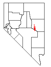
The Humboldt–Toiyabe National Forest (HTNF) is the principal U.S. National Forest in the U.S. state of Nevada, and has a smaller portion in Eastern California. With an area of 6,289,821 acres (25,454.00 km2), it is the largest U.S. National Forest outside of Alaska.

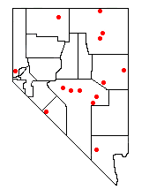
The Toiyabe Range is a mountain range in Lander and Nye counties, Nevada, United States. Most of the range is included within the Humboldt-Toiyabe National Forest. The highest point in the range, near its southern end, is Arc Dome, an area protected as the Arc Dome Wilderness. The highest point in Lander County, Bunker Hill, is also located within the Toiyabe Range. The range starts in northwestern Nye County north of Tonopah, Nevada and runs approximately 120 miles (190 km) north-northeast into southern Lander County, making it the second longest range in the state.

Mount Charleston, including Charleston Peak at 11,916 feet (3,632 m), is the highest mountain in both the Spring Mountains and Clark County, in Nevada, United States. It is the eighth-highest mountain in the state. Well separated from higher peaks by large, low basins, Charleston Peak is the most topographically prominent peak in Nevada, and the eighth-most-prominent peak in the contiguous United States. It is one of eight ultra-prominent peaks in Nevada. It is located about 35 miles (56 km) northwest of Las Vegas within the Mount Charleston Wilderness, which is within the Spring Mountains National Recreation Area of the Humboldt–Toiyabe National Forest.

Wheeler Peak is the tallest mountain in the Snake Range and in White Pine County, in Nevada, United States. The summit elevation of 13,065 feet (3,982 m) makes it the second-highest peak in Nevada, just behind Boundary Peak. With a topographic prominence of 7,563 feet (2,305 m), Wheeler Peak is the most topographically prominent peak in White Pine County and the second-most prominent peak in Nevada, just behind Mount Charleston. The mountain is located in Great Basin National Park and was named for George Wheeler, leader of the Wheeler Survey of the late 19th century.

Boundary Peak is a mountain in Esmeralda County, Nevada, United States. With a peak elevation of 13,147 feet (4,007 m), it is the highest natural point in the state of Nevada.
The White Pine Range is a group of mountains in southern White Pine County, in eastern Nevada. The range runs for approximately 51 miles (82 km) from Beck Pass in the north to Currant Pass in the south. To the west of the range are the Duckwater (Shoshone) tribal lands and the northern arm of large Railroad Valley. To the east are Jakes Valley and the northern part of the long White River Valley. To the south are the Horse and Grant Ranges.

Currant Mountain is the highest mountain in the White Pine Range in White Pine County, Nevada, United States. It is the twenty-first-highest mountain in the state, and also ranks as the sixteenth-most topographically prominent peak in the state. Its summit consists of a series of three spires on a thin limestone ridge, with the southern spire being the highest at 11,518 feet (3,511 m). To the west are the Duckwater (Shoshone) tribal lands and the northern arm of large Railroad Valley. To the east is the northern part of White River Valley. The peak is located about 37 miles (60 km) southwest of the community of Ely near the Nye County border, within the Currant Mountain Wilderness of the Humboldt-Toiyabe National Forest.

Mount Moriah is a 12,072-foot (3,680 m) mountain in the northern Snake Range of eastern White Pine County, Nevada, United States. It is the fifth-highest mountain in the state, and also ranks as the ninth-most topographically prominent peak in the state. It is located in the Mount Moriah Wilderness administered by the Humboldt-Toiyabe National Forest.
In 1989 the U.S. Government enacted the Nevada Wilderness Bill, expanding the one existing Wilderness Area (Jarbidge) and creating thirteen new areas. The estimated total of 733,400 acres (296,800 ha) was over eleven times the area that had previously been under wilderness protection.

The Alta Toquima Wilderness is a protected wilderness area in the Toquima Range of Nye County, in the central section of the state of Nevada in the western United States. It covers an area of 35,860 acres (14,510 ha), and is administered by the Humboldt-Toiyabe National Forest. The Mount Jefferson Research Natural Area protects 4,953 acres (2,004 ha) around Mount Jefferson, the highest peak in the Toquima Range and Nye County. The Mount Jefferson Research Natural Area is one of the most unusual environments in the United States, due to its extreme alpine conditions. Wildlife is plentiful in the Wilderness, including bighorn sheep, deer, grouse, chukar and native trout.

Arc Dome is the highest mountain of the Toiyabe Range in northwestern Nye County, Nevada, United States. It is the thirteenth-highest mountain in the state. Arc Dome also ranks as the second-most topographically prominent peak in Nye County and the eighth-most prominent peak in the state. The peak is located about 53 miles (85 km) north of the community of Tonopah, within the Arc Dome Wilderness of the Humboldt-Toiyabe National Forest.

North Schell Peak is the highest mountain in the Schell Creek Range of White Pine County, Nevada, United States. It is the ninth-highest mountain in the state, and also ranks as the fifth-most topographically prominent peak in the state. The summit is 19 miles (31 km) northeast of the community of Ely within the High Schells Wilderness of the Humboldt-Toiyabe National Forest.

Troy Peak is the highest mountain in the Grant Range in northeastern Nye County, Nevada, United States. It is the thirty-sixth highest mountain in Nevada. Troy Peak also ranks as the third-most topographically prominent peak in Nye County and the fourteenth-most prominent peak in the state. The summit is located 72 miles (116 km) southwest of the city of Ely, within the Grant Range Wilderness of the Humboldt-Toiyabe National Forest.

Freel Peak is a mountain located in the Carson Range, a spur of the Sierra Nevada, near Lake Tahoe in California.

Mount Rose is the highest mountain in Washoe County, within the Carson Range of Nevada, United States. It ranks thirty-seventh among the most topographically prominent peaks in the state. It is also both the highest and most topographically prominent peak of the greater Sierra Nevada range within the state of Nevada, and the third most topographically prominent peak in the Sierra Nevada overall. It is located in the Mount Rose Wilderness of the Humboldt-Toiyabe National Forest. An extinct volcano, the mountain is in between Lake Tahoe and Reno. State Route 431 traverses Mount Rose Summit southeast of Mount Rose. Due to the high elevation, most of the precipitation that falls on the mountain is snow. The view from Mount Rose facing east is the Truckee Meadows, the second largest population center in Nevada.

Sacajawea Peak is a peak in the Wallowa Mountains, in the U.S. state of Oregon. It is in the Eagle Cap Wilderness and the Wallowa–Whitman National Forest.

Matterhorn is the highest mountain in the Jarbidge Mountains of northern Elko County, Nevada, United States. It is the fifteenth-most topographically prominent peak in the state. The summit is located in the Jarbidge Wilderness, which is administered by the Jarbidge Ranger District of the Humboldt-Toiyabe National Forest. Its name is derived from the Matterhorn in the Alps of Europe, due mainly to the cliffs located immediately adjacent to the summit on the north and northeast.

Jarbidge Peak is the second highest mountain in the Jarbidge Mountains of northern Elko County, Nevada, United States. It is located within the Jarbidge Ranger District of the Humboldt-Toiyabe National Forest. The boundary of the Jarbidge Wilderness crosses the peak.
Table Mountain, at 10,649 feet (3,246 m) is the highest summit of the Monitor Range in south-central Nevada in the United States. It is located within the Humboldt-Toiyabe National Forest, about 50 miles (80 km) northeast of Tonopah. The Table Mountain Wilderness is named after it.


