
Alaska is a non-contiguous U.S. state on the northwest extremity of North America. Part of the Western United States region, it is one of the two non-contiguous U.S. states, alongside Hawaii. Alaska is also considered to be the northernmost, westernmost, and easternmost state in the United States. It borders the Canadian territory of Yukon and the province of British Columbia to the east. It shares a western maritime border, in the Bering Strait, with Russia's Chukotka Autonomous Okrug. The Chukchi and Beaufort Seas of the Arctic Ocean lie to the north, and the Pacific Ocean lies to the south. Technically, it is a semi-exclave of the U.S., and is the largest exclave in the world.

Dillingham Census Area is a census area located in the state of Alaska, United States. At the 2020 census, the population was 4,857, slightly up from 4,847 in 2010. It is part of the unorganized borough and therefore has no borough seat. Its largest community by far is the city of Dillingham, on a small arm of Bristol Bay on the Bering Sea.

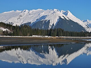
Juneau, officially the City and Borough of Juneau, is the capital of the U.S. state of Alaska, located along the Gastineau Channel and the Alaskan panhandle. Juneau was named the capital of Alaska in 1906, when the government of what was then the District of Alaska was moved from Sitka as dictated by the U.S. Congress in 1900. On July 1, 1970, the City of Juneau merged with the City of Douglas and the surrounding Greater Juneau Borough to form the current consolidated city-borough, which ranks as the second-largest municipality in the United States by area and is larger than either Rhode Island or Delaware.
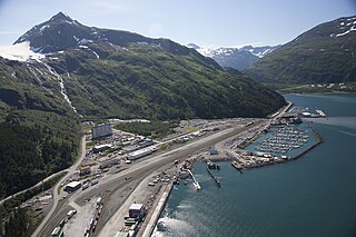
Whittier is a city at the head of the Passage Canal in the U.S. state of Alaska, about 58 miles (93 km) southeast of Anchorage. The city is within the Chugach Census Area, one of the two entities established in 2019 when the former Valdez–Cordova Census Area was dissolved. It is also a port for the Alaska Marine Highway. The population was 272 at the 2020 census, having increased from 220 in 2010.

Denali is the highest mountain peak in North America, with a summit elevation of 20,310 feet (6,190 m) above sea level. It is the tallest mountain in the world from base-to-peak on land, measuring 18,000 ft (5,500 m), with a topographic prominence of 20,194 feet (6,155 m) and a topographic isolation of 4,621.1 miles (7,436.9 km), Denali is the third most prominent and third-most isolated peak on Earth, after Mount Everest and Aconcagua. Located in the Alaska Range in the interior of the U.S. state of Alaska, Denali is the centerpiece of Denali National Park and Preserve.

Redoubt Volcano, or Mount Redoubt, is an active stratovolcano in the largely volcanic Aleutian Range of the U.S. state of Alaska. Located at the head of the Chigmit Mountains subrange in Lake Clark National Park and Preserve, the mountain is just west of Cook Inlet, in the Kenai Peninsula Borough about 110 miles (180 km) southwest of Anchorage. At 10,197 feet (3,108 m), in just over 5 miles (8.0 km) Mount Redoubt attains 9,150 feet (2,790 m) of prominence over its surrounding terrain. It is the highest summit in the Aleutian Range. In 1976, Redoubt Volcano was designated as a National Natural Landmark by the National Park Service.
Anchorage, officially the Municipality of Anchorage, is the most populous city in the U.S. state of Alaska. With a population of 291,247 at the 2020 census, it contains nearly 40 percent of the state's population. The Anchorage metropolitan area, which includes Anchorage and the neighboring Matanuska-Susitna Borough, had a population of 398,328 in 2020, accounting for more than half the state's population. At 1,706 sq mi (4,420 km2) of land area, the city is the fourth-largest by area in the U.S.
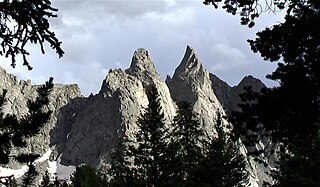
Buck Mountain is a mountain located in the Teton Range, Grand Teton National Park, Wyoming, immediately southeast of Grand Teton.

The climate of the United States varies due to changes in latitude, and a range of geographic features, including mountains and deserts. Generally, on the mainland, the climate of the U.S. becomes warmer the farther south one travels, and drier the farther west, until one reaches the West Coast.

The Mountain states form one of the nine geographic divisions of the United States that are officially recognized by the United States Census Bureau. It is a subregion of the Western United States.

Bashful Peak is a mountain in the U.S. state of Alaska, located in Chugach State Park. At 8,005 ft (2,440 m), Bashful is the highest peak in Chugach State Park, and the highest peak in the Municipality of Anchorage. The peak carries snow year-round and several small glaciers hang from its steep western face.
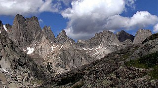
Watch Tower is a mountain located in the southern Wind River Range in the U.S. state of Wyoming. Watch Tower is on the west side of the Cirque of the Towers, a popular climbing area and is just southeast of Block Tower. Watch Tower is immediately east of the Continental Divide.

Block Tower is a mountain located in the southern Wind River Range in the U.S. state of Wyoming. Block Tower is on the west side of the Cirque of the Towers, a popular climbing area and is just northwest of Watch Tower and immediately south of the peak known as Sharks Nose. Block Tower is situated on the Continental Divide.
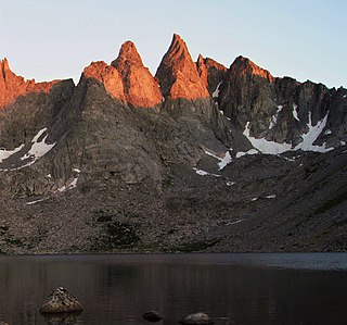
Sharks Nose is a mountain located in the southern Wind River Range in the U.S. state of Wyoming. Sharks Nose is on the west side of the Cirque of the Towers, a popular climbing area. The peak is just north of Block Tower and immediately south of the peak known as Overhanging Tower. Sharks Nose is situated on the Continental Divide.
Overhanging Tower is a mountain located in the southern Wind River Range in the U.S. state of Wyoming. Overhanging Tower is on the west side of the Cirque of the Towers, a popular climbing area. The peak is just north of Sharks Nose and south of the peak known as Wolfs Head. Overhanging Tower is situated on the Continental Divide.
Wolfs Head is a mountain located in the southern Wind River Range in the U.S. state of Wyoming. Wolfs Head is on the northwest side of the Cirque of the Towers, a popular climbing area. The peak is just north of Overhanging Tower and connected to Pingora Peak by a narrow arête. The East Ridge route on the Wolf's Head is recognized in the historic climbing text Fifty Classic Climbs of North America and considered a classic climb. Wolfs Head is situated on the Continental Divide.
Mount Ernest Gruening is a 6,015+ ft glaciated mountain summit located in the Boundary Ranges of the Coast Mountains, in the U.S. state of Alaska. The long ridge-like mountain is situated between the Herbert Glacier and Eagle Glacier at the west edge of the Juneau Icefield, 20 mi (32 km) northwest of Juneau, Alaska, and 8 mi (13 km) east of Favorite Channel, on land managed by Tongass National Forest. Although modest in elevation, relief is significant since the east face of the mountain rises over 3,500 feet above the Herbert Glacier in less than one mile, and the west aspect rises 5,800 feet above the Eagle River valley in two miles.

The Snow Towers is a 7,100+ ft glaciated mountain summit located in the Boundary Ranges of the Coast Mountains, in the U.S. state of Alaska. The two peaks, 0.1 mi apart, are situated at the apex of the Taku and Herbert Glaciers near the western edge of the Juneau Icefield, 23 mi (37 km) north of Juneau, 1.8 mi (3 km) southwest of Snowpatch Crag, and 6.3 mi (10 km) northeast of Mount Ernest Gruening, on land managed by Tongass National Forest. The mountain was named by members of the Juneau Icefield Research Project in 1964, and was officially adopted in 1965 by the U.S. Board on Geographic Names. The first ascent was made in 1984 by Charles "Dick" Ellsworth and Bruce Tickell.

Taku Towers is a 6,653+ ft double summit mountain located in the Boundary Ranges of the Coast Mountains, in the U.S. state of Alaska. The two north and south peaks, 0.2 mi apart with 6,653+ and 6,605-ft elevations respectively, are situated in the Taku Range of the Juneau Icefield, 21 mi (34 km) north of Juneau, Alaska, and 5.5 mi (9 km) east-southeast of The Snow Towers, on land managed by Tongass National Forest. The Taku Range is a north-south trending ridge on the edge of the Taku Glacier. The mountain's name was in local use when first published in 1960 by the U.S. Geological Survey. Several landforms in the vicinity bear this Taku name, which all ultimately derive from the Taku people. The first ascent was made in 1949 by Forbes, Merritt, and Schoeblen via the west ridge. Daniel Reid and party made the first ascent of the difficult east face of South Taku Tower in 1973.

Snowpatch Crag is a 6,345 ft (1,930 m) elevation glaciated mountain summit located in the Boundary Ranges of the Coast Mountains, in the U.S. state of Alaska. Snowpatch Crag is a nunatak surrounded by the Taku Glacier, and is situated near the west side of the Juneau Icefield, 25 mi (40 km) north of Juneau, and 1.8 mi (3 km) northeast of The Snow Towers, on land managed by Tongass National Forest. The mountain was named by members of the Juneau Icefield Research Project in 1964, and was officially adopted in 1965 by the U.S. Board on Geographic Names. Variant names for this geographic feature are "Snowpatch Peak" and "Snowpatch Craig."
