Satellite image of the Olympic PeninsulaThe Olympic Peninsula and Olympic National ParkOlympic Coast National Marine SanctuaryQueets RiverMount Olympus
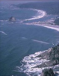
The Olympic Peninsula is a large peninsula in Western Washington that lies across Puget Sound from Seattle, and contains Olympic National Park. It is bounded on the west by the Pacific Ocean, the north by the Strait of Juan de Fuca, and the east by Hood Canal. Cape Alava, the westernmost point in the contiguous United States, and Cape Flattery, the northwesternmost point, are on the peninsula. Comprising about 3,600 square miles (9,300km2), the Olympic Peninsula contained many of the last unexplored places in the contiguous United States. It remained largely unmapped until Arthur Dodwell and Theodore Rixon mapped most of its topography and timber resources between 1898 and 1900.[1]
Clallam and Jefferson Counties, as well as the northern parts of Grays Harbor and Mason Counties, are on the peninsula. The Kitsap Peninsula, bounded by the Hood Canal and Puget Sound, is an entirely separate peninsula and is not connected to the Olympic Peninsula.
From Olympia, the state capital, U.S. Route 101 runs along the Olympic Peninsula's eastern, northern, and western shorelines.
The Olympic mountain range sits in the center of the Olympic Peninsula. This range is the second largest in Washington State. Its highest peak is Mt. Olympus.
A major effort called the Wild Olympics campaign is under way to protect additional wilderness areas on the Olympic Peninsula, protect salmon streams under the Wild and Scenic River Act and provide a means for Olympic National Park to offer to buy land adjacent to the Park from willing sellers.
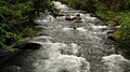
The Olympic Peninsula is home to temperate rain forests, including the Hoh, Queets Rain Forest, and Quinault. Rain forest vegetation is concentrated primarily in the western part of the peninsula, as the interior mountains create a rain shadow effect in areas to the northeast, resulting in a much drier climate in those locales.
This page is based on this Wikipedia article Text is available under the CC BY-SA 4.0 license; additional terms may apply. Images, videos and audio are available under their respective licenses.