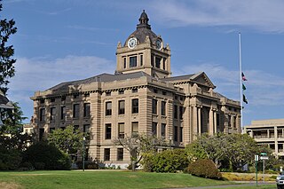
Grays Harbor County is a county in the U.S. state of Washington. As of the 2020 census, the population was 75,636. Its county seat is Montesano, and its largest city is Aberdeen. Grays Harbor County is included in the Aberdeen Micropolitan Statistical Area.

Harbor Hills is a census-designated place (CDP) in southern Licking County, Ohio, United States. The population was 1,565 at the 2020 census.
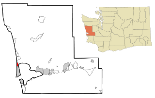
Brady is a census-designated place (CDP) in Grays Harbor County, Washington, United States. The population was 676 at the 2010 census.

Copalis Beach is a census-designated place (CDP) in Grays Harbor County, Washington, United States. The population was 415 at the 2010 census.

Grayland is a census-designated place (CDP) in Grays Harbor County, Washington, United States. The population was 953 at the 2010 census.

Moclips is an unincorporated community and census-designated place (CDP) in Grays Harbor County, Washington, United States. The population was 207 at the 2010 census. It is located near the mouth of the Moclips River.

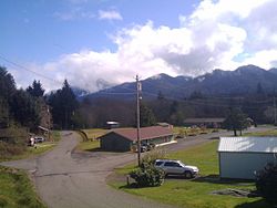
Neilton is an unincorporated community and census-designated place (CDP) in Grays Harbor County, Washington, United States. The population was 315 at the 2010 census.

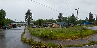
Taholah is a unincorporated village on the Quinault Indian Reservation, in Grays Harbor County, Washington, United States. Named for a Quinault chief in 1905, its population was 840 at the 2010 census. For statistical purposes, the United States Census Bureau has defined Taholah as a census-designated place (CDP). The headquarters for the Quinault Indian Nation was moved to Taholah from the town of Quinault on the shore of Lake Quinault.
Brinnon is a census-designated place (CDP) in Jefferson County, Washington, United States. The population was 797 at the 2010 census. The community is named for Ewell P. Brinnon, who in 1860 took a donation land claim at the mouth of the Duckabush River. Its known landmarks include Dosewallips State Park and Black Point Marina. Camp Parsons, founded in 1919 and the oldest Boy Scout camp west of the Mississippi River, sits just outside the north end of the CDP.

Pacific Beach is a census-designated place (CDP) in Grays Harbor County, Washington, United States. The population was 291 at the 2010 census. Prior to 2010 it was part of the Moclips CDP.

The Olympic Peninsula is a large arm of land in western Washington that lies across Puget Sound from Seattle, and contains Olympic National Park. It is bounded on the west by the Pacific Ocean, the north by the Strait of Juan de Fuca, and the east by Hood Canal. Cape Alava, the westernmost point in the contiguous United States, and Cape Flattery, the northwesternmost point, are on the peninsula. Comprising about 3,600 square miles (9,300 km2), the Olympic Peninsula contained many of the last unexplored places in the contiguous United States. It remained largely unmapped until Arthur Dodwell and Theodore Rixon mapped most of its topography and timber resources between 1898 and 1900.

Western Washington is a region of the United States defined as the area of Washington state west of the Cascade Mountains. This region is home to the state's largest city, Seattle, the state capital, Olympia, and most of the state's residents. The climate is generally far more damp and temperate than that of Eastern Washington.
Queets is an unincorporated community and census-designated place (CDP) in Grays Harbor and Jefferson counties, Washington, United States. The population was 174 at the 2010 census. The primary residents of the community are Native Americans of the Quinault Indian Nation.
Hogans Corner is a census-designated place (CDP) in Grays Harbor County, Washington, United States. The population was 85 at the 2010 census. Prior to 2010 it was part of the combined Oyehut-Hogan's Corner CDP.
Oyehut is a census-designated place (CDP) in Grays Harbor County, Washington, United States. The population was 85 at the 2010 census. Prior to 2010 it was part of the combined Oyehut-Hogan's Corner CDP.

The Humptulips River is a river in Grays Harbor County, Washington, in the United States. Its main tributaries are the East Fork Humptulips River, about 20 miles (32 km) long (32 km), and West Fork Humptulips River, about 30 miles (48 km) long (48 km). After the forks join, the main river is approximately 20 miles (32 km) long.
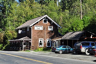
Quinault is an unincorporated community in Grays Harbor County, Washington, United States. Quinault is located on the Olympic Peninsula.
Santiago is a census-designated place (CDP) in Grays Harbor County, Washington, United States, named after Joseph Santiago. The population was 42 at the 2010 census.
Qui-nai-elt Village is a census-designated place (CDP) in Grays Harbor County, Washington, United States. The population was 54 at the 2010 census.
The Moclips Highway, also designated as BIA Road 26, is a rural east–west highway in the U.S. state of Washington. It travels about 22 miles (35 km) from a junction with State Route 109 near Moclips on the Pacific Ocean, through the Quinault Indian Reservation, to U.S. Route 101 near Lake Quinault.