The Olympic Mountains are a mountain range on the Olympic Peninsula of the Pacific Northwest of the United States. The mountains, part of the Pacific Coast Ranges, are not especially high – Mount Olympus is the highest summit at 7,980 ft (2,432 m); however, the eastern slopes rise precipitously out of Puget Sound from sea level, and the western slopes are separated from the Pacific Ocean by the low-lying 20 to 35 km wide Pacific Ocean coastal plain. These densely forested western slopes are the wettest place in the 48 contiguous states. Most of the mountains are protected within the bounds of Olympic National Park and adjoining segments of the Olympic National Forest.

The Olympic Peninsula is a large arm of land in western Washington that lies across Puget Sound from Seattle, and contains Olympic National Park. It is bounded on the west by the Pacific Ocean, the north by the Strait of Juan de Fuca, and the east by Hood Canal. Cape Alava, the westernmost point in the contiguous United States, and Cape Flattery, the northwesternmost point, are on the peninsula. Comprising about 3,600 square miles (9,300 km2), the Olympic Peninsula contained many of the last unexplored places in the contiguous United States. It remained largely unmapped until Arthur Dodwell and Theodore Rixon mapped most of its topography and timber resources between 1898 and 1900.
Olympic National Forest is a U.S. National Forest located in Washington, USA. With an area of 628,115 acres (254,189 ha), it nearly surrounds Olympic National Park and the Olympic Mountain range. Olympic National Forest contains parts of Clallam, Grays Harbor, Jefferson, and Mason counties. The landscape of the national forest varies, from the temperate Olympic rain forest to the salt water fjord of Hood Canal to the peaks of Mt. Washington.

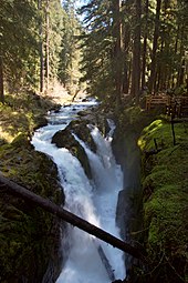
The Hoh River is a river of the Pacific Northwest, located on the Olympic Peninsula in the U.S. state of Washington. About 56 miles (90 km) long, the Hoh River originates at the snout of Hoh Glacier on Mount Olympus and flows westward through the Olympic Mountains of Olympic National Park and Olympic National Forest, then through foothills in a broad valley, emptying into the Pacific Ocean at the Hoh Indian Reservation. The final portion of the Hoh River's course marks the boundary between the south coastal segment of Olympic National Park and the Hoh Indian Reservation.

The Bogachiel River is a river of the Olympic Peninsula in the U.S. state of Washington. It originates near Bogachiel Peak, and flows westward through the mountains of Olympic National Park. After emerging from the park it joins the Sol Duc River, forming the Quillayute River, which empties into the Pacific Ocean near La Push, Washington.

Mount Olympus, at 7,980 feet (2,430 m), is the tallest and most prominent mountain in the Olympic Mountains of the U.S. state of Washington. Located on the Olympic Peninsula, it is also a central feature of Olympic National Park. Mount Olympus is the highest summit of the Olympic Mountains; however, peaks such as Mount Constance and The Brothers, on the eastern margin of the range, are better known, being visible from the Seattle metropolitan area.

Kalaloch is an unincorporated resort area entirely within Olympic National Park in western Jefferson County, Washington, United States. Kalaloch accommodations, which include a lodge, rental cabins, and campgrounds, are on a 50-foot (15 m) bluff overlooking the Pacific Ocean, west of U.S. Route 101 on the Olympic Peninsula, north of the reservation of the Quinault Indian Nation.
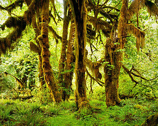
Hoh Rainforest is one of the largest temperate rainforests in the U.S., located on the Olympic Peninsula in western Washington state. It includes 24 miles (39 km) of low elevation forest 394 to 2,493 feet along the Hoh River. The Hoh River valley was formed thousands of years ago by glaciers.
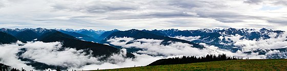
Hurricane Ridge is a mountainous area in Washington's Olympic National Park. Approximately 18 miles (29 km) by road from Port Angeles, the ridge is open to hiking, skiing, and snowboarding and is one of the two most visited sites in the national park.

The Pacific Northwest Trail (PNT) is a 1,200-mile (1,900 km) hiking trail running from the Continental Divide in Montana to the Pacific Ocean on Washington's Olympic Coast. Along the way, the PNT crosses three national parks, seven national forests, and two other national scenic trails. It travels against the grain of several mountain ranges, including the Continental Divide, Whitefish Divide, Purcells, Selkirks, Kettles, Cascades, and Olympics. It was designated as the Pacific Northwest National Scenic Trail by Congress in 2009.

The Cummins Creek Wilderness is a 9,300-acre (3,800 ha) wilderness area in the Siuslaw National Forest within the Oregon Coast. It is one of three wilderness areas created in the Siuslaw in 1984, along with Drift Creek and Rock Creek. It is "dedicated to preserve in a wilderness state, the last remaining virgin stands of Sitka spruce, western hemlock and Douglas-fir, in Oregon's coast lands." Cummins Creek and nearby Cummins Ridge are named for F.L. Cummins, an early homesteader.

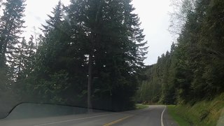
U.S. Route 101 (US 101) is a United States Numbered Highway that runs along the West Coast from Los Angeles, California to Tumwater, Washington. Within the state of Washington, US 101 connects cities on the coast of the Pacific Ocean and encircles the Olympic Peninsula around the Olympic Mountains. It also serves as the main access for Olympic National Park, several state parks, and other scenic and recreational areas.

Salmo-Priest Wilderness is a 41,335 acre (167.28 km2) wilderness area located in the Selkirk Mountains in the northeast corner of Washington state, within the Colville National Forest and the Kaniksu National Forest.
There are many diverse trails within Olympic National Park. These trails traverse many different biomes, allowing hikers to explore from the coast of the Pacific Ocean to the summit of Mount Olympus. The trails vary in length from less than a mile and a few minutes hike to many miles and multiple days. The Pacific Northwest National Scenic Trail traverses the park from east to west, and has approximately 135 miles within its borders. The trails are divided into five separate areas, Staircase/Dosewallips Trails, Hurricane/Elwha Trails, Quinault/ Queets Trails, Hoh/Bogachiel/Sol Duc Trails, and Coastal Routes.

Mount Skokomish Wilderness is a designated wilderness area in the southeast portion of Olympic National Forest on the Olympic Peninsula of Washington in the United States. The wilderness area comprises 13,291 acres (5,379 ha) administered by the U.S. Forest Service.
The Peter Roose Homestead is a historic homestead in the U.S. state of Washington that was settled by Peter Roose, an immigrant from Bollnäs, Sweden, in 1907. Located in Olympic National Park, the site was added as a historic district to the National Register of Historic Places in 2007.

Mount Carrie is a 6,995-foot (2,132-metre) mountain summit located within Olympic National Park in Clallam County of Washington state. Mt. Carrie is the highest point in the Bailey Range which is a subrange of the Olympic Mountains. With a good eye and clear weather, the mountain can be seen from the visitor center at Hurricane Ridge. Its nearest higher peak is Mount Mathias (7,156 ft) which is an outlier of Mount Olympus, 6.24 mi (10.04 km) to the south. Due to heavy winter snowfalls, Mount Carrie supports the Carrie Glacier in its northeast cirque, and Fairchild Glacier on the east slope. Precipitation runoff from the mountain drains into tributaries of the Elwha River and Hoh River. There is a scrambling route via the High Divide Trail and Cat Walk.

Stephen Peak is a 6,418-foot (1,956-metre) mountain summit located within Olympic National Park in Jefferson County of Washington state. Stephen Peak is the fifth-highest peak in the Bailey Range, which is a subrange of the Olympic Mountains. In clear weather, the mountain can be seen from the visitor center at Hurricane Ridge, appearing to the left of Mount Olympus. Mount Ferry is set 2.26 mi (3.64 km) to the southeast, and Stephen's nearest higher neighbor is Ruth Peak which is an outlier of Mount Carrie, 2.1 mi (3.4 km) to the northwest. Precipitation runoff from the mountain drains into tributaries of the Elwha River and Hoh River. The first ascent of this peak was made in 1961 by Kent Heathershaw, Doug Waali, and Robert Wood.
The Bailey Range is a mountain range located within Olympic National Park in Washington state.

Hurricane Hill is a 5,757-foot (1,755 m) mountain summit located within Olympic National Park in Clallam County of Washington state. It is part of the Olympic Mountains and is situated at the western end of Hurricane Ridge within the Daniel J. Evans Wilderness. Hurricane Hill is nine miles south-southwest of Port Angeles and two miles northwest of the park's Hurricane Ridge Visitor Center. Precipitation runoff from the mountain drains to the Elwha River via various tributaries. Topographic relief is significant as the southwest aspect rises 5,100 feet (1,600 m) above the Elwha Valley in three miles.


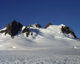 The summit of Mount Olympus from the Blue Glacier
 Subalpine fir in a meadow on Hurricane Ridge
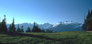
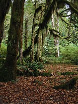
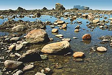
 Foggy sea stacks