
Lopez Island is the third largest of the San Juan Islands and an unincorporated town in San Juan County, Washington, United States. Lopez Island is 29.81 square miles (77.2 km2) in land area. The 2020 census population was 3,156, though the population swells in the summer, as second homes, rental houses, and campsites fill up.

Orcas Island is the largest of the San Juan Islands of the Pacific Northwest, in northwestern Washington, United States.

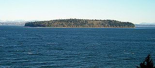
Sucia Island is located 2.5 miles (4.0 km) north of Orcas Island in the San Juan Islands, San Juan County, Washington, United States. It is the largest of an archipelago of ten islands including Sucia Island, Little Sucia, Ewing, Justice, Herndon, the Cluster Islands islets, and several smaller, unnamed islands. The group of islands is about 2.5 miles (4.0 km) in length and just short of a half mile wide. Sucia island is roughly the shape of a hand. The total land area of all islands is 2.74 km2. The main island of Sucia Island by itself is 2.259 km2. There was a permanent population of four persons as of the 2000 census, all on Sucia Island. Sucia Island State Park is a Washington State Marine Park.
Blake Island is a Puget Sound island in Kitsap County, Washington, United States, that is preserved as Blake Island Marine State Park. The island lies north of Vashon Island, south of Bainbridge Island, and east of Manchester. On the northeast end of the island is Tillicum Village, a showcase for Northwest Coast Indian arts, culture, and food. The park is managed by the Washington State Parks and Recreation Commission.

Moran State Park is a public recreation area on Orcas Island in Puget Sound's San Juan Islands in the state of Washington, United States. The state park encompasses over 5,000 acres of various terrain including forests, wetlands, bogs, hills, and lakes. It is the largest public recreation area in the San Juan Islands and the fourth largest state park in the state. A park focal point is the observation tower atop Mount Constitution, the highest point in San Juan County at 2,407 feet.
Jones Island State Park is a Washington state park coterminous with Jones Island, one of the San Juan Islands in San Juan County, Washington, USA. It is located one mile (1.6 km) west of the southwestern corner of Orcas Island and accessible only by boat. The island has a land area of 188 acres (76 ha) and no resident population. The island was named by the Wilkes Expedition in 1841 for naval officer Jacob Jones.
Henry Island is one of the San Juan Islands of San Juan County, Washington, United States. It lies just off the northwest shore of San Juan Island. The small Pearl Island also lies between Henry Island and San Juan Island at its northern end. Just northwest of the northern tip of Henry Island lies Battleship Island, a State bird sanctuary. Except for Stuart Island, Henry Island is the westernmost of the San Juan Islands. It has a land area of 4.126 km² and had a total of19 permanent residents as of the 2010 census.

Larrabee State Park is a public recreation area located on Samish Bay on the western side of Chuckanut Mountain, 6 mi (9.7 km) south of the city of Bellingham, Washington. It was created in 1915 as Washington's first state park. The park covers 2,748 acres (1,112 ha) and features fishing, boating, and camping as well as mountain trails for hiking and biking. It is managed by the Washington State Parks and Recreation Commission.
Turn Island, is a 34-acre (14 ha) island in the San Juan Islands in the Salish Sea in the U.S. state of Washington. The island sits in the San Juan Channel about 900 feet off the eastern edge of San Juan Island. It is preserved as Turn Island Marine State Park and is part of the San Juan Islands National Wildlife Refuge. The island has 12 campsites and is only accessible by water.
Patos Island is a small island in the San Juan Islands of the U.S. state of Washington. Since 1893, it has been home to the Patos Island Lighthouse, guiding vessels through Boundary Pass between Canada and the United States. The name comes from the Spanish pato, meaning "duck," which was given to the island in 1792 by Commander Dionisio Alcalá Galiano of the Sutil and Captain Cayetano Valdés y Flores of the Mexicana.

Clark Island is an island in the San Juan Islands of the Pacific Northwest, located near Barnes Island off the northeast coast of Orcas Island. It is part of the U.S. state of Washington. Clark Island Marine State Park, which encompasses the entire 55-acre (22 ha) island, has two picnicking sites, 15 primitive campsites, and nine mooring buoys.
Blind Island Marine State Park is a public recreation area consisting of the entirety of Blind Island, a three-acre (1.2 ha) island at the entrance to Blind Bay on Shaw Island in San Juan County, Washington. It is part of the San Juan Islands National Monument. The island lies one-third of a mile west of the Shaw Island ferry terminal and has 1,280 feet (390 m) of saltwater shoreline. The park is cooperatively managed by the U.S. Bureau of Land Management and Washington State Parks.

Cutts Island State Park is a public recreation area park comprising the entirety of two-acre (0.81 ha) Cutts Island in Carr Inlet in Pierce County, Washington. The island is a clay butte with a stand of trees and a teardrop-shaped beach at low tide. It sits one half-mile offshore from Kopachuck State Park and is accessible only by water and occasionally by sandbar at extremely low tide. Eight mooring buoys are available for boaters. Park activities include beachcombing and scuba diving.
Eagle Island State Park is a public recreation area in south Puget Sound occupying the entirety of Eagle Island in Pierce County, Washington. The five-acre (2.0 ha) island sits in Balch Passage between McNeil and Anderson islands about 750 feet (230 m) off Anderson Island's north shore. The island was named for Harry Eagle, one of the party members of the Wilkes Expedition of 1841.

Fort Townsend State Park is a public recreation area located two miles south of Port Townsend in Jefferson County, Washington. The state park occupies a third of the site of the original Fort Townsend built in 1856. The park includes 3,960 feet (1,210 m) of shoreline on Port Townsend Bay, picnicking and camping areas, 6.5 miles (10.5 km) of hiking trails, and facilities for boating, fishing, and crabbing.

Posey Island State Park is a popular recreation area consisting of 1-acre (0.40 ha) Posey Island in San Juan County, Washington. The island is located .25 miles (0.40 km) north of Pearl Island, near Roche Harbor, San Juan Island. It has about 1,000 feet (300 m) of saltwater shoreline and is part of the Cascadia Marine Trail, with campsites restricted to visitors arriving in non-motorized watercraft. The island-park is managed by the Washington State Parks and Recreation Commission. It became a state park in 1960 under lease from the U.S. Bureau of Land Management.
Stuart Island State Park in San Juan County, Washington is a marine camping park in the Washington State Park System. It consists of 433 acres (175 ha) of land and waterways on and around Stuart Island, named for Frederick D. Stuart, clerk to explorer Charles Wilkes.
Upright Channel Park is a former unit of the Washington State Park System consisting of 20 acres (8.1 ha) of island, beach, and tidelands on Upright Channel in the northwest corner of Lopez Island. The park was not listed as a Washington State Parks property as of March 2014. San Juan County assumed management of the property per a memorandum of understanding in May 2014.
Doe Island State Park is a public recreation area comprising the entirety of Doe Island, a seven-acre (2.8 ha) island lying some 300 feet (91 m) off the eastern flank of Orcas Island in the San Juan Islands group in San Juan County, Washington. It has 2,049 feet (625 m) of shoreline and a trail three-tenths of a mile long that circles the island. It is only accessible by water. The Washington State Parks originally acquired a portion of the island from the Bureau of Land Management in 1964 for $15.27, with a second acquisition in 1967 from the DNR at no cost.
Saddlebag Island Marine State Park is a public recreation area made up of 26-acre (11 ha) Saddlebag Island, part of the San Juan Islands, in Skagit County, Washington. The island sits in Padilla Bay four miles (6.4 km) northeast of Anacortes, Washington. Dot Island and Huckleberry Island lie nearby. Saddlebag Island was held in private ownership until 1974, when the state purchased it for $192,000 for use as a state park.


