Palouse to Cascades State Park Trail

Last updated

Palouse to Cascades State Park Trail
John Wayne Pioneer Trail - east end of Iron Horse park.jpg
Rail cut in the eastern end of the Iron Horse State Park portion of the Palouse to Cascades State Park Trail as it nears the Columbia River south of Vantage
Length285 miles (459 km) [1]
Location Washington, United States
Established1981
UseHiking
SeasonYear-round
Surface Gravel
Right of way Railways
Maintained by Washington State Parks and Recreation Commission
Trail map
Palouse to Cascades State Park Trail
The Saddle Mountains as seen from the Palouse to Cascades State Park Trail. Photo looking east southeasterly at Boylston tunnel Boylston Tunnel Mouth - Saddle Mountains-John Wayne Trail.JPG
The Saddle Mountains as seen from the Palouse to Cascades State Park Trail. Photo looking east southeasterly at Boylston tunnel

The Palouse to Cascades State Park Trail, formerly known as the John Wayne Pioneer Trail and the Iron Horse Trail, is a rail trail that spans most of the U.S. state of Washington. It follows the former railway roadbed of the Chicago, Milwaukee, St. Paul & Pacific Railroad (Milwaukee Road) for 300 miles (480 km) across two-thirds of the state, from the western slopes of the Cascade Mountains to the Idaho border.

Contents

The former Milwaukee Road roadbed was acquired by the state of Washington via a quitclaim deed, and is used as a non-motorized recreational trail managed by the Washington State Parks and Recreation Commission and by the Washington State Department of Natural Resources. State legislation "railbanked" the corridor with provisions that allow for the reversion to railroad usage in the future.

History

The trail was originally a railroad line which was decommissioned in 1980. Afterwards, establishing a public right-of-way trail on the land was championed by various people and organizations, especially by Chic Hollenbeck, who founded the John Wayne Pioneer Wagons and Riders Association in the 1980s. Beginning in 1981, Hollenbeck and his organization organized annual horse and wagon rides across Washington along the trail. The organization aimed to fortify the public-ownership of the land, in opposition to nearby private property owners’ extralegal efforts to exert control over the land for their own use. [2] [3] When it was officially established, the eastern part of the trail took on the name "John Wayne Trail" after the organization that lobbied for its existence, themselves being named after actor John Wayne, while the western 100-mile (160 km) portion from Cedar Falls (near North Bend) to the Columbia River south of Vantage was named the "Iron Horse Trail" and had been developed and managed as the Iron Horse State Park.

In 2002, it was designated a National Recreation Trail. [4]

In 2015, two Washington state representatives from the 9th district attempted to include language in an amendment to the state's 2015 capital budget that would close a 130-mile-long (210 km) section of the trail east of the Columbia River. It was later revealed that a typo, referring to the closed section as "from the Columbia River to the Columbia River", nullified the amendment temporarily. [5] [6]

In April 2018, Washington State Parks proposed renaming the trail and Iron Horse State Park to resolve confusion. [7] [3] Additionally, the name did not conform to the State Parks naming policies. [3] The Washington State Parks and Recreation Commission adopted a new name, the Palouse to Cascades State Park Trail, in May of that year. [8]

In April 2022, the Beverly Railroad Bridge across the Columbia River reopened to provide access for hikers, cyclists, and horse riders following the trail. The railroad trestle, south of Vantage, was renovated at a cost of $5.5 million by the state government. Other sections of the trail in Eastern Washington remain unfinished or in need of replacement. [1]

Trail features

Army West Trailhead near Beverly Washington John Wayne Trail- Army West Trailhead- from road looking north.jpg
Army West Trailhead near Beverly Washington

Iron Horse Park access

Access points to the developed portion of the trail, managed by Washington State Parks and Recreation Commission, are at: [9]

Tunnels

The trail features six tunnels, including the longest trail tunnel in the world, the 11,894-foot (3,625 m) Snoqualmie Tunnel, which was #50 on the railroad's numbering system. The other five tunnels in order are the Boylston (#45), Thorp (#46), Picnic Area (#47), Easton (#48) and Whittier (#49). The Boylston Tunnel was also known as the Johnson Creek tunnel to the railroad and sometimes tunnels #46 and #47 are known as the Thorp Tunnels.

Undeveloped

The trail runs along the east side of Rock Lake in the Rock Creek drainage; the former railroad grade climbing the basalt walls of the lake can be seen A Rock Lake looking east.jpg
The trail runs along the east side of Rock Lake in the Rock Creek drainage; the former railroad grade climbing the basalt walls of the lake can be seen

Access points to the undeveloped portion of the trail, managed by Washington State Department of Natural Resources, have not been formally opened to the public. However, the trail provides access to the unique geological erosion features of the Channeled Scablands regions of the state of Washington, and several stretches have been recognized as providing access to this area created by the cataclysmic Missoula Floods that swept periodically across eastern Washington and down the Columbia River Plateau during the Pleistocene epoch. At Malden, once home to the largest railroad turntable in the world, Washington State Parks is planning a trailhead in the former rail yard.[ citation needed ]

Iron Horse State Park

Mine Creek Trestle in Iron Horse State Park near Snoqualmie Pass Ex-Milwaukee Road railroad trestle over Mine Creek on John Wayne Pioneer Trail.jpg
Mine Creek Trestle in Iron Horse State Park near Snoqualmie Pass
Bridge across the Yakima River and the BNSF Railway line at Lake Easton Iron Horse Trail 9083.JPG
Bridge across the Yakima River and the BNSF Railway line at Lake Easton
Cross-country skiing on the Iron Horse State Park trail IronHorseStateParkTrailXCSkiing.JPG
Cross-country skiing on the Iron Horse State Park trail

Iron Horse State Park, part of the Washington State Park System and the Palouse to Cascades State Park Trail, is a 1,612-acre (7 km2) state park located in the Cascade Mountains and Yakima River Valley, between Cedar Falls on the west and the Columbia River on the east.

The park is contiguous with a rail trail that crosses Snoqualmie Pass. The trail is located within the former right-of-way of The Milwaukee Road, officially the Chicago, Milwaukee, St. Paul and Pacific Railroad. Most of the right-of-way between Cedar Falls and the Idaho border was acquired by the state, through a quitclaim deed, as a result of the railroad's 1977 bankruptcy. As part of the reorganization of the company, the railroad embargoed its lines west of Miles City, Montana, in 1980 and ceased service in Washington. The state acquired the land in the early 1980s and eventually converted the right-of-way west of the Columbia River into a 110-mile (177 km) hiking, mountain biking, and horseback riding trail. The trail continues beyond Iron Horse State Park to the Idaho border. [10] [11] Iron Horse State Park contains the most developed portion of the trail.

At Cedar Falls, the west end of Iron Horse State Park, the Palouse to Cascades State Park Trail connects to the Snoqualmie Valley Trail of the King County Regional Trail System. [12] The Snoqualmie Valley Trail is built on a portion of the former Milwaukee Road branch line from Cedar Falls to Everett.

Recreation

Like most rails-to-trails projects, Iron Horse is popular with hikers and cyclists. There are many trail heads across the state, most with modern facilities, ample parking for a less common trail, and even a handful of campgrounds. [13]

The trail passes through mostly woodland, along lakes and waterfalls, and goes directly through the divide at the old Snoqualmie Tunnel. The park is easily accessible from I-90.

Iron Horse is popular for its scenery and its history, although it is less well-known than other nearby areas like the Alpine Lakes Wilderness or Snoqualmie Falls.

The park trail continues through the Town of South Cle Elum where the preserved Milwaukee Road depot and substation, as well as the remains of the rail yard are located. The depot, substation, and rail yard are listed in the National Register of Historic Places. There is a small museum in the depot. In Kittitas, the trail passes The Milwaukee Road depot and the ruins of one of the substations. That depot is also listed in the National Register of Historic Places. In addition to these buildings, other infrastructure remains, such as tunnels and bridges.

See also

Related Research Articles

<span class="mw-page-title-main">Snoqualmie Pass, Washington</span> Census-designated place in Washington, United States

Snoqualmie Pass is a census-designated place (CDP) in Kittitas County, Washington, United States. It includes the unincorporated community of Hyak. The population was 311 at the 2010 census.

<span class="mw-page-title-main">Thorp, Washington</span> Census-designated place in Washington, United States

Thorp is an unincorporated community and census-designated place (CDP) in Kittitas County, Washington, United States. In 2015, the population was 317 according to statistics compiled by Data USA.

The Seattle, Lake Shore and Eastern Railway (SLS&E) was a railroad founded in Seattle, Washington, on April 28, 1885, with three tiers of purposes: Build and run the initial line to the town of Ballard, bring immediate results and returns to investors; exploit resources east in the valleys, foothills, Cascade Range, and Eastern Washington in 19th-century style, attracting more venture capital; and boost a link to a transcontinental railroad for Seattle, the ultimate prize for incorporation. The historical accomplishment of the line was Seattle to Sumas at the border, with British Columbia, Canada, connecting with the Canadian Pacific transcontinental at the border at Huntingdon, British Columbia, now part of the City of Abbotsford.

<span class="mw-page-title-main">Snoqualmie Tunnel</span>

The Snoqualmie Tunnel is a former railroad tunnel near Snoqualmie Pass in the U.S. state of Washington, located east of Seattle. The tunnel crosses the Cascade Range about three miles (5 km) south of the pass, which is used by Interstate 90, on the border between King County and Kittitas County. It is 11,894 feet long and is at an approximate elevation of 2,600 feet (790 m) above sea level, just north of Keechelus Lake. Its east portal is at Hyak.

Naches Pass is a mountain pass in the Cascade Range in the state of Washington. It is located about 50 miles (80 km) east of Tacoma and about 50 miles (80 km) northwest of Yakima, near the headwaters of tributary streams of the Naches River on the east and the Greenwater River on the west. The boundaries of Pierce, King, Kittitas, and Yakima counties come together at the pass. The pass lies on the boundary between the Mount Baker-Snoqualmie and Wenatchee National Forests, about 10 miles (16 km) northeast of Mount Rainier National Park. There are no roadways or railways crossing the pass.

<span class="mw-page-title-main">Hyak, Washington</span> Unincorporated community in Washington, United States

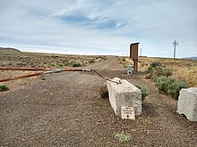
Hyak is an unincorporated community located on Snoqualmie Pass in Kittitas County, Washington. It is located within the Snoqualmie Pass CDP.

<span class="mw-page-title-main">Keechelus Lake</span> Natural lake, reservoir in Washington, U.S.

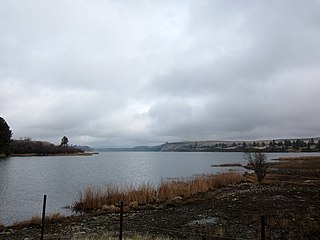
Keechelus Lake is a lake and reservoir in the northwest United States, near Hyak in Kittitas County, Washington. Approximately fifty miles (80 km) southeast of Seattle and a few miles southeast of Snoqualmie Pass, it is the source of the Yakima River.

<span class="mw-page-title-main">Interstate 90 in Washington</span> Interstate highway in Washington

Interstate 90 (I-90), designated as the American Veterans Memorial Highway, is a transcontinental Interstate Highway that runs from Seattle, Washington, to Boston, Massachusetts. It crosses Washington state from west to east, traveling 298 miles (480 km) from Seattle across the Cascade Mountains and into Eastern Washington, reaching the Idaho state line east of Spokane. I-90 intersects several of the state's other major highways, including I-5 in Seattle, I-82 and U.S. Route 97 (US 97) near Ellensburg, and US 395 and US 2 in Spokane.

<span class="mw-page-title-main">South Cle Elum Yard</span> United States historic place

The Chicago, Milwaukee, St. Paul and Pacific Railroad South Cle Elum Rail Yard located in South Cle Elum, Washington, was a division point on the Chicago, Milwaukee, St. Paul and Pacific Railroad's Coast Division. It was established by the railroad in 1909 during construction of its "Pacific Extension".

<span class="mw-page-title-main">Snoqualmie Pass</span> Mountain pass in Washington state, U.S.

Snoqualmie Pass is a mountain pass that carries Interstate 90 (I-90) through the Cascade Range in the U.S. state of Washington. The pass summit is at an elevation of 3,015 feet (919 m), on the county line between Kittitas County and King County.

<span class="mw-page-title-main">Columbia Plateau Trail</span> Trail in Washington state, US

The Columbia Plateau State Park Trail is a 130-mile-long (210 km), 20-foot-wide (6.1 m) corridor in eastern Washington state maintained as part of the Washington State Park system. The rail trail runs along the abandoned right-of-way of the former Spokane, Portland and Seattle Railway.

<span class="mw-page-title-main">Beverly Railroad Bridge</span> Bridge in Beverly, Washington

The Beverly Railroad Bridge is a historic railroad bridge that now carries hikers, bicyclists, and pedestrians over the Columbia River near Beverly, Washington, United States. It was constructed by the Chicago, Milwaukee, St. Paul and Pacific Railroad in 1909 during its Pacific Extension. In 1906, The Milwaukee Road began construction on its transcontinental rail line from Chicago, Illinois to Tacoma, Washington, which was completed three years later.

Milwaukee Ski Bowl was an alpine ski area in the northwest United States in Washington, which operated between 1937 and 1950. It was southeast of Seattle in the Cascade Range at Hyak, on the east side of Snoqualmie Pass.

<span class="mw-page-title-main">Rock Lake (Washington)</span> Kolk lake in Whitman County, WA

Rock Lake is the deepest and largest of all scabland lakes left behind from the Missoula Floods, and holds that distinction for all of eastern Washington. At its deepest, it is more than 360 feet (110 m) deep, although the official measurement is uncertain. The lake is over 7 miles (11 km) long and averages 1 mile (1.6 km) in width, and is accessible via a solitary landing area located on the south end. The rest of the shoreline is inaccessible to vehicles, other than a few private properties.

<span class="mw-page-title-main">Martin, Washington</span> Ghost town in Washington (state)

Martin is an extinct town in the northwest United States, in Kittitas County, Washington. Stampede Pass is near to the west.

Rockdale is an extinct town in the northwest United States, in King County, Washington. The GNIS classifies it as a populated place.

<span class="mw-page-title-main">Outline of Washington (state) infrastructure</span> Overview of and topical guide to infrastructure of the U.S. state of Washington

The following outline is provided as an overview of and topical guide to infrastructure of the U.S. state of Washington.

References

  1. 1 2 Banse, Tom (April 12, 2022). "Riding or hiking across Washington state just got easier with new bridge over Columbia River". KUOW. Retrieved April 13, 2022.
  2. "About the Palouse to Cascades Trail". John Wayne Pioneer Wagons and Riders Association. n.d. Retrieved September 3, 2021.
  3. 1 2 3 Paul, Crystal (April 17, 2018). "Washington may rename the cross-state John Wayne Pioneer Trail; here's why". The Seattle Times . Retrieved September 3, 2021.
  4. "John Wayne Pioneer Trail". American Trails. February 28, 2013. Retrieved August 14, 2014.
  5. "Typo stalls effort to close part of John Wayne Trail". Seattle Daily Journal of Commerce . Associated Press. September 24, 2015. Retrieved September 25, 2015.
  6. Babcock, John (September 23, 2015). "Wording error keeps John Wayne Trail open" . Moscow-Pullman Daily News . Retrieved September 25, 2015.
  7. Bonar, Kayla (April 2, 2018). "State looks at renaming Iron Horse-John Wayne trail". Yakima Herald . Archived from the original on April 2, 2018. Retrieved April 14, 2018.
  8. Paul, Crystal (May 17, 2018). "Former John Wayne Pioneer Trail renamed Palouse to Cascades State Park Trail". The Seattle Times. Retrieved May 17, 2018.
  9. Brochure: 'Your Guide to the John Wayne Pioneer Trail – Iron Horse State Park'; Washington State Parks and Recreation Commission; undated (copy distributed at trailheads in 2008)
  10. "Trails". Washington State Parks and Recreation Commission. Retrieved February 18, 2016.
  11. "Iron Horse State Park". Washington State Parks and Recreation Commission. Retrieved February 18, 2016.
  12. "Snoqualmie Valley Trail". King County Regional Trail System. Department of Natural Resources and Parks, Parks and Recreation Division. September 19, 2005. Archived from the original on October 1, 2006. Retrieved April 21, 2006.
  13. "Washington State Tour Planning and Bicycling Maps". Collection of maps and resources. WSDOT. 2006. Archived from the original (Web and PDF) on August 6, 2007. Retrieved July 3, 2007.

Bibliography

Commons-logo.svg Media related to John Wayne Pioneer Trail at Wikimedia Commons

47°13′45″N117°14′59″W / 47.22917°N 117.24972°W / 47.22917; -117.24972