Pierce National Wildlife Refuge

Last updated
Pierce National Wildlife Refuge
IUCN category IV (habitat/species management area)
USA Washington location map.svg
Red pog.svg
Location Skamania County, Washington, United States
Nearest city North Bonneville, Washington
Coordinates 45°37′48″N122°00′01″W / 45.6301°N 122.0003°W / 45.6301; -122.0003 Coordinates: 45°37′48″N122°00′01″W / 45.6301°N 122.0003°W / 45.6301; -122.0003 [1]
Area 329.38 acres (133.30 ha) [2]
Established 1983 (1983) [3]
Governing body U.S. Fish and Wildlife Service
Website Pierce National Wildlife Refuge

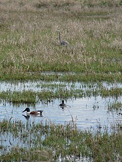
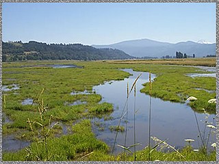
Pierce National Wildlife Refuge is located in southwest Washington within the Columbia River Gorge National Scenic Area. It encompasses wetlands and uplands along the north shore of the Columbia River west of the town of North Bonneville. Refuge habitats include wetlands, Columbia River riparian corridor blocks, transitional woodlands from willows to cottonwood/ash to white oak to Douglas fir, improved pastures with some native grasses, and numerous creeks, seeps, and springs. [4]

Wetland A land area that is permanently or seasonally saturated with water

A wetland is a distinct ecosystem that is inundated by water, either permanently or seasonally, where oxygen-free processes prevail. The primary factor that distinguishes wetlands from other land forms or water bodies is the characteristic vegetation of aquatic plants, adapted to the unique hydric soil. Wetlands play a number of functions, including water purification, water storage, processing of carbon and other nutrients, stabilization of shorelines, and support of plants and animals. Wetlands are also considered the most biologically diverse of all ecosystems, serving as home to a wide range of plant and animal life. Whether any individual wetland performs these functions, and the degree to which it performs them, depends on characteristics of that wetland and the lands and waters near it. Methods for rapidly assessing these functions, wetland ecological health, and general wetland condition have been developed in many regions and have contributed to wetland conservation partly by raising public awareness of the functions and the ecosystem services some wetlands provide.

Columbia River River in the Pacific Northwest of the United States

The Columbia River is the largest river in the Pacific Northwest region of North America. The river rises in the Rocky Mountains of British Columbia, Canada. It flows northwest and then south into the US state of Washington, then turns west to form most of the border between Washington and the state of Oregon before emptying into the Pacific Ocean. The river is 1,243 miles (2,000 km) long, and its largest tributary is the Snake River. Its drainage basin is roughly the size of France and extends into seven US states and a Canadian province. The fourth-largest river in the United States by volume, the Columbia has the greatest flow of any North American river entering the Pacific.

North Bonneville, Washington City in Washington, United States

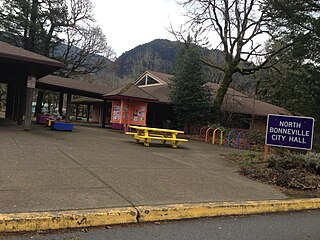
North Bonneville is a city in Skamania County, Washington, United States. The population was 593 at the 2000 census and 956 at the 2010 census.

Hardy Creek, which bisects the refuge from east to west, supports one of the last remaining runs of chum salmon on the Columbia River. In addition to chum salmon, the creek also supports small remnant runs of coho salmon, steelhead, and Chinook salmon as well as a variety of native species of freshwater fish. The refuge headquarters also serves as the main office for Steigerwald Lake and Franz Lake National Wildlife Refuges. Visitor opportunities are limited to arranged group tours and viewing from the summit of Beacon Rock and the Hamilton Mountain Trail (both located in Beacon Rock State Park). [4]

Chum salmon species of fish

The chum salmon is a species of anadromous fish in the salmon family. It is a Pacific salmon, and may also be known as dog salmon or keta salmon, and is often marketed under the name silverbrite salmon. The name chum salmon comes from the Chinook Jargon term tzum, meaning "spotted" or "marked", while keta in the scientific name comes from the Evenki language of Eastern Siberia via Russian.

Coho salmon species of fish

The coho salmon is a species of anadromous fish in the salmon family, one of the several species of Pacific salmon. Coho salmon are also known as silver salmon or "silvers". The scientific species name is based on the Russian common name kizhuch (кижуч).

Rainbow trout species of trout

The rainbow trout is a trout and species of salmonid native to cold-water tributaries of the Pacific Ocean in Asia and North America. The steelhead is an anadromous (sea-run) form of the coastal rainbow trout(O. m. irideus) or Columbia River redband trout (O. m. gairdneri) that usually returns to fresh water to spawn after living two to three years in the ocean. Freshwater forms that have been introduced into the Great Lakes and migrate into tributaries to spawn are also called steelhead.

Related Research Articles

Willapa Bay

Willapa Bay is a bay located on the southwest Pacific coast of Washington state in the United States. The Long Beach Peninsula separates Willapa Bay from the greater expanse of the Pacific Ocean. With over 260 square miles (670 km2) of water surface Willapa Bay is the second-largest estuary on the United States Pacific coast. Early settlers called the bay Shoalwater Bay and this name is found on old maps and charts of the region.

Gifford Pinchot National Forest protected area in the state of Washington, United States

Gifford Pinchot National Forest is a National Forest located in southern Washington, USA, managed by the United States Forest Service. With an area of 1.32 million acres (5300 km2), it extends 116 km along the western slopes of Cascade Range from Mount Rainier National Park to the Columbia River. The forest straddles the crest of the South Cascades of Washington State, spread out over broad, old growth forests, high mountain meadows, several glaciers, and numerous volcanic peaks. The forest's highest point is at 12,276 ft. at the top of Mount Adams, the second tallest volcano in the state after Rainier. It includes the 110,000-acre (450 km2) Mount St. Helens National Volcanic Monument, established by Congress in 1982

Ridgefield National Wildlife Refuge American wildlife preserve

Ridgefield National Wildlife Refuge is a wildlife preserve, one of the national wildlife refuges operated by the United States Fish and Wildlife Service, located in the westernmost part of Clark County, Washington. The refuge protects more than 5,200 acres (2,100 ha) of marshes, grasslands, and woodlands. The refuge was established in 1965, in response to a need to establish vital winter habitat for wintering waterfowl with an emphasis on the dusky Canada goose whose nesting areas in Alaska were severely impacted by the violent earthquake of 1964.

Upper Mississippi River National Wildlife and Fish Refuge

The Upper Mississippi River National Wildlife and Fish Refuge is a 240,000-acre (970 km2), 261-mile long (420 km) National Wildlife Refuge located in and along the Upper Mississippi River. It runs from Wabasha, Minnesota in the north to Rock Island, Illinois in the south.

Cross Creeks National Wildlife Refuge

Cross Creeks National Wildlife Refuge is a part of the U.S. system of National Wildlife Refuges located along the Lake Barkley impoundment of the Cumberland River in Stewart County, Tennessee near Dover, covering 8,862 acres (35.86 km2). It provides habitat for a wide variety of waterfowl and aquatic plant life in what is a largely wetlands environment. Cross Creeks is the only National Wildlife Refuge located entirely in Middle Tennessee as of 2006.

Egegik River river in Alaska, United States

The Egegik River is a waterway in the U.S. state of Alaska. A biological survey was conducted at the base of the Alaska Peninsula in 1902 by Wilfred Hudson Osgood, which included the Egegik River.

Tualatin River National Wildlife Refuge

The Tualatin River National Wildlife Refuge is a 1,856 acres (751 ha) wetlands and lowlands sanctuary in the northwestern part of the U.S. state of Oregon. Established in 1992 and opened to the public in 2006, it is managed by the United States Fish and Wildlife Service. Located in southeastern Washington County, 15 miles (24 km) southwest of Portland, the refuge is bordered by Sherwood, Tualatin and Tigard. A newer area, extending into northern Yamhill County, is located further west near the city of Gaston surrounding the former Wapato Lake.

Kenai National Wildlife Refuge

The Kenai National Wildlife Refuge is a 1.92-million-acre (7,770 km2) wildlife habitat preserve located on the Kenai Peninsula of Alaska, United States. It is adjacent to Kenai Fjords National Park. This refuge was created in 1941 as the Kenai National Moose Range, but in 1980 it was changed to its present status by the Alaska National Interest Lands Conservation Act. The refuge is administered from offices in Soldotna.

DArbonne National Wildlife Refuge

D'Arbonne National Wildlife Refuge is a National Wildlife Refuge of the United States located north of West Monroe, Louisiana. It is in Ouachita and Union Parishes on either side of Bayou D'Arbonne near its confluence with the Ouachita River. It lies on the western edge of the Mississippi River alluvial valley. It was established in 1975 to protect bottomland hardwoods and provide wintering habitat for migratory waterfowl. D'Arbonne is one of four refuges managed in the North Louisiana Refuges Complex.

Wapato Lake

Wapato Lake was a historic lake located in what became parts of Washington County and Yamhill County in the U.S. state of Oregon. The area is sometimes known as Wapato Lake Bed and Wapato Flat. The lake bed is located about a half mile east of Gaston at 55 metres (180 ft) elevation. The lake bed soils contain a layer of organic peat that once supported a wetland community dominated by the wapato plant, Sagittaria latifolia, particularly in the upper marsh areas.

Elochoman River river in the United States of America

The Elochoman River is a tributary of the Columbia River, in the U.S. state of Washington. It is about 15 miles (24 km) long.

Kanuti National Wildlife Refuge

Kanuti National Wildlife Refuge is a national wildlife refuge in central Alaska, United States. One of 16 refuges in Alaska, it was established in 1980 when Congress passed The Alaska National Interest Lands Conservation Act (ANILCA). At 1,640,000 acres (6,600 km2), Kanuti Refuge is about the size of the state of Delaware. Located at the Arctic Circle, the refuge is a prime example of Alaska's boreal ecosystem. It is dominated by black and white spruce, with some white birch and poplars.

Silvio O. Conte National Fish and Wildlife Refuge

Silvio O. Conte National Fish and Wildlife Refuge was established in 1997 to conserve, protect and enhance the abundance and diversity of native plant, fish and wildlife species and the ecosystems on which they depend throughout the 7,200,000-acre (29,000 km2) Connecticut River watershed. The watershed covers large areas of Vermont, New Hampshire, Massachusetts and Connecticut. It contains a great diversity of habitats, notably: northern forest valuable as nesting habitat for migrant thrushes, warblers and other birds; rivers and streams used by shad, salmon, herring and other migratory fishes; and an internationally significant complex of high-quality tidal fresh, brackish and salt marshes.

Franz Lake National Wildlife Refuge

Franz Lake National Wildlife Refuge is located in southwest Washington State, within the Columbia River Gorge National Scenic Area. The refuge provides a variety of habitats including riparian wetlands, Columbia River riparian corridor blocks, transitional woodlands from lower elevation willows, and cottonwoods to mid-elevation old-growth fir and cedar with associated native understory shrubs, open meadows, and numerous streams and seeps.

McNary National Wildlife Refuge

McNary National Wildlife Refuge is a wildlife preserve, one of the national wildlife refuges operated by the United States Fish and Wildlife Service. Extending along the east bank of the Columbia River in southeastern Washington, from the confluence of the Snake River to the mouth of the Walla Walla River, and downstream into Oregon, McNary NWR is located in rural Burbank, but very close to the rapid development of the Tri-Cities. In fact, the refuge meets the definition of an "urban refuge." Few areas in North America support waterfowl populations in the extraordinary numbers found here. Visitors enjoy spectacular concentrations of Canada geese, mallards, and other waterfowl. More than half the mallards in the Pacific Flyway overwinter at some time in this portion of the Columbia River Basin.

Steigerwald Lake National Wildlife Refuge

Located on the Columbia River, 10 miles (16 km) east of Vancouver, Washington, the 1,049-acre Steigerwald Lake National Wildlife Refuge consists of historic riverine flood plain habitat, semi-permanent wetlands, cottonwood-dominated riparian corridors, pastures, and remnant stands of Oregon white oak.

Toppenish National Wildlife Refuge

Toppenish National Wildlife Refuge is located on the Yakama Indian Reservation about 6 miles south of Toppenish, Washington, in the agriculturally intensive Yakima Valley of eastern Washington state. Using the waters of Toppenish and Snake Creeks and supplemented with summer irrigation, managers are able to provide a mosaic of refuge wetlands interspersed with lush riparian and native upland habitats.

Cold Springs National Wildlife Refuge

Cold Springs National Wildlife Refuge is a 3,117-acre (12.61 km2) National Wildlife Refuge located 7 miles (10 km) northeast of Hermiston and 3 miles (5 km) south of the Columbia River in Umatilla County, Oregon; The refuge was established in 1909 as a preserve and breeding ground for native birds. It consists of diverse wetland habitats surrounded by upland habitat of big sagebrush and native steppe grasses. A riparian component of willow and cottonwood provides refuge for birds, mammals, and other animals.

Whittlesey Creek National Wildlife Refuge

Whittlesey Creek National Wildlife Refuge is part of a large wetland complex on Lake Superior, near Ashland, Wisconsin. These coastal wetlands are a significant part of the wildlife habitat and aquatic resources of the south shore of Lake Superior.

Salt Creek Wilderness

Salt Creek Wilderness is a designated Wilderness Area located on the Pecos River approximately 12 miles north-east of Roswell, New Mexico. Established in 1970 as a unit of the Bitter Lake National Wildlife Refuge, the 9,621 acre Wilderness is administered by the U. S Fish and Wildlife Service. Combining the scrub lands of the Chihuahuan Desert with the riparian environment of the Pecos River and the Artesian basin of eastern New Mexico, Salt Creek represents a rare convergence of desert and wetlands.

References

PD-icon.svg This article incorporates  public domain material from websites or documents ofthe United States Fish and Wildlife Service .

United States Fish and Wildlife Service US Federal Government agency

The United States Fish and Wildlife Service is an agency of the US Federal Government within the US Department of the Interior dedicated to the management of fish, wildlife, and natural habitats. The mission of the agency is "working with others to conserve, protect, and enhance fish, wildlife, plants and their habitats for the continuing benefit of the American people."

  1. "Pierce National Wildlife Refuge (Fws)". protectedplanet.net. Archived from the original on 2012-06-14.
  2. "Annual Report of Lands as of September 30, 2013" (PDF). United States Fish and Wildlife Service.
  3. "About the Refuge". Pierce National Wildlife Refuge. U.S. Fish and Wildlife Service.
  4. 1 2 "Pierce National Wildlife Refuge Profile". U.S. Fish and Wildlife Service.