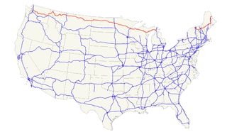
U.S. Route 2 or U.S. Highway 2 (US 2) is an east–west U.S. Highway spanning 2,571 miles (4,138 km) across the northern continental United States. US 2 consists of two segments connected by various roadways in southern Canada. Unlike some routes, which are disconnected into segments because of encroaching Interstate Highways, the two portions of US 2 were designed to be separate in the original 1926 highway plan.
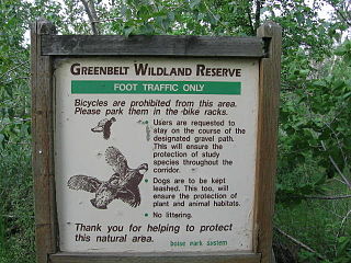
The Boise River Greenbelt is a recreational and alternate transportation trail along the banks of the Boise River through Boise, Idaho, United States. The Boise Greenbelt is more of a greenway than a green belt since its character is linear. It extends more than 20 miles (32 km) beginning at Lucky Peak Dam in the east to a short distance beyond Eagle Road in the west in Eagle, Idaho. Taking into account both sides of the river and other parallel trails and spurs, the total Greenbelt trail system measures more than 30 miles (48 km).

The Flaming Geyser State Park is located on the Green River in southwestern King County, Washington, near the city of Black Diamond. The park was named for a flame which burned through a concrete basin, fueled by a methane gas pocket 1,000 feet below the surface. When the pocket was discovered by prospective coal miners in the early 1900s, the test hole hit gas and saltwater, shooting water and flames 25 feet into the air. The same methane pocket seeps gas through a mud hole to create the "Bubbling Geyser" nearby. Both "geysers" can be found along a short hike, though as of 2016 the flaming geyser is no longer lit due to depletion of its methane source.

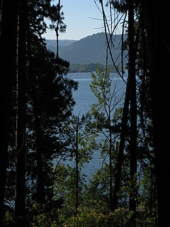
Lake Coeur d'Alene is a dam-controlled lake in northern Idaho, in the northwest United States. Its northern end is in the city of Coeur d'Alene. It spans 25 miles (40 km) in length and ranges from 1 to 3 miles (5 km) wide with over 109 miles (175 km) of shoreline.
The Cowboy Trail is a rail trail in northern Nebraska. It is a multi-use recreational trail suitable for bicycling, walking and horseback riding. It occupies an abandoned Chicago and North Western Railway corridor. When complete, the trail will run from Chadron to Norfolk, a length of 321 miles (517 km), making it the longest rails-to-trails conversion in the United States. It is Nebraska's first state recreational trail. The trail runs across the Outback area of Nebraska.

Iron Horse State Park, part of the Washington State Park System, is a 1,612-acre (7 km2) state park located in the Cascade Mountains and Yakima River Valley, between Cedar Falls on the west and the Columbia River on the east.

Neighborhoods in Spokane, Washington are officially grouped by the Spokane City Council into three main city council districts: 1, 2, and 3. Each city council district contains multiple, official neighborhoods that are recognized with a neighborhood council. Informally, neighborhoods are colloquially grouped by local geographical, geological, cultural, or historical features The list of neighborhoods below is organized based on the official designations by the City of Spokane. Unofficial neighborhoods and districts are listed within the official neighborhood in which they are located.
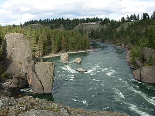
The Trail of the Coeur d'Alenes is a rail trail in the northwest United States, in northern Idaho. It follows the former Union Pacific Railroad right-of-way from Mullan, a mountain mining town near the Montana border, westward to Plummer, a town on the prairie near the Washington border. Generally following the Coeur d'Alene River, the rail line was abandoned in 1991 and the trail officially opened in March 2004.

Lookout Pass Ski and Recreation Area is a ski area in the western United States. It is at Lookout Pass on Interstate 90, on the border of Idaho and Montana, five miles (8 km) east of Mullan, Idaho. It has a summit elevation of 5,650 ft (1,720 m) on Runt Mountain with a vertical drop of 1,150 ft (350 m) on the northeast-facing slopes. Lookout Pass operates five days per week during the ski season, and daily during the Christmas vacation break.

Mount Spokane State Park is a public recreation area located in the Selkirk Mountains, 23 miles (37 km) northeast of the city of Spokane, Washington. The state park surrounds 5,883-foot (1,793 m) Mount Spokane and other peaks including Mount Kit Carson, Beauty Mountain, and Quartz Mountain. The park receives 300 inches (7.6 m) of snow annually and is home to Mount Spokane Ski and Snowboard Park as well as an extensive system of trails for hiking, biking, and horseback riding. As of 2018, Washington State Parks reported its acreage as 12,293 acres (4,975 ha), making it Washington's largest state park, slightly ahead of Riverside State Park which lies 23 miles to the southwest.
Interstate 90 (I-90) is a transcontinental Interstate Highway that runs from Seattle, Washington, to Boston, Massachusetts. It crosses Washington state from west to east, traveling 298 miles (480 km) from Seattle across the Cascade Mountains and into Eastern Washington, reaching the Idaho state line east of Spokane. I-90 intersects several major north–south highways, including I-5 in Seattle, I-82 and U.S. Route 97 (US 97) near Ellensburg, and US 395 and US 2 in Spokane.
Interstate 90 (I-90) is a transcontinental Interstate Highway that runs east–west across the northern United States. Within the state of Idaho, the freeway travels for 74 miles (119 km) from the Washington border near Spokane to Coeur d'Alene and the panhandle region at the north end of the state. After traveling through the Silver Valley along the Coeur d'Alene River in the Bitterroot Range, I-90 crosses into Montana at Lookout Pass.
U.S. Route 2 (US 2) is a component of the United States Numbered Highway System that connects the city of Everett in the U.S. state of Washington to the Upper Peninsula of Michigan, with a separate segment that runs from Rouses Point, New York, to Houlton, Maine. Within Washington, the highway travels on a 326.36-mile-long (525.23 km) route that connects the western and eastern regions of the state as a part of the state highway system and the National Highway System. US 2 forms parts of two National Scenic Byways, the Stevens Pass Greenway from Monroe to Cashmere and the Coulee Corridor Scenic Byway near Coulee City, and an All-American Road named the International Selkirk Loop within Newport.

The 900-mile (1,448 km) Idaho Centennial Trail (ICT) is a scenic trail through Idaho. It winds its way through various ecosystems from high desert canyonlands in southern Idaho to wet mountain forests in Northern Idaho. ICT travelers will cross many mountains, streams and rivers in between.
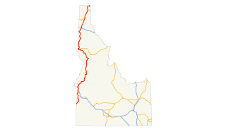
In the U.S. state of Idaho, U.S. Route 95 is a north–south highway near the western border of the state, stretching from Oregon to British Columbia for over 538 miles (866 km); it was earlier known in the state as the North and South Highway.

The North Idaho Centennial Trail is a 24 miles (39 km) paved trail in Idaho used for transportation and recreational activities. Extending from Higgens Point on the northeast side of Lake Coeur d'Alene, a popular place for bald eagle watchers in early winter, the trail follows the lake's north shoreline to the Spokane River where it follows it to the Idaho/Washington border. On the other side of the state border, the trail becomes the Spokane River Centennial Trail and extends for another 37 miles (60 km) out to Sontag Park in Nine Mile Falls, Washington. The trail passes through the towns of Post Falls, Idaho and Coeur d'Alene, Idaho.
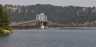
Heyburn State Park is a public recreation area in Benewah County, Idaho, in the United States. The state park was founded in 1908 and is the oldest state park in the Pacific Northwest. The park has 5,744 acres (23.2 km2) of land and 2,332 acres (9.4 km2) of water on three lakes: Benewah, Chatcolet, and Hidden. A dam constructed on the Spokane River in Spokane in 1906 raised the level of Lake Coeur d'Alene, connecting it to the park's three lakes. The surface elevation of the lakes is 2,125 feet (648 m) above sea level. The park's year-round recreational opportunities include camping, boating, hiking, horseback riding, fishing, and picnicking.

The Bill Chipman Palouse Trail is a paved rail trail in the northwestern United States, from Pullman, Washington, eastward to Moscow, Idaho. Completed 21 years ago in 1998, it follows the former Union Pacific Railroad right-of-way and connects the rural university towns on the Palouse across the state border.