Peace Arch Park

Last updated

Peace Arch Park
Peace-Arch-3614 edit.jpg
Peace Arch Park, seen from the Canadian side
Location Canada and United States
Nearest city Blaine, Washington/Surrey, British Columbia
Coordinates 49°00′07.5″N122°45′24″W / 49.002083°N 122.75667°W / 49.002083; -122.75667
AreaCanada: 22 acres (8.9 ha)
U.S.: 20 acres (8.1 ha)
EstablishedNovember 7, 1939
Governing bodyCanada: BC Parks
U.S.: Washington State Parks
The Peace Arch monument Peace Arch, U.S.-Canada border.jpg
The Peace Arch monument

Peace Arch Park is an international park consisting of Peace Arch Historical State Park in Washington, United States and Peace Arch Provincial Park in British Columbia, Canada. The park straddles the international boundary between the two countries at the extreme western end of the main contiguous section of the two countries' land border, between Blaine, Washington, United States, and Surrey, British Columbia, Canada, where it reaches Semiahmoo Bay of the Salish Sea on the continent's Pacific Coast. [1] 
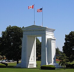
The park's central feature is the Peace Arch.

Contents

The park is located at the Peace Arch Border Crossing (also known as the Douglas Border Crossing), where Highway 99 in British Columbia and Interstate 5 in Washington State meet. The park's northern portion is about 9 hectares (22 acres) and is managed by the British Columbia Ministry of Environment. [2] The southern portion is about 20 acres (8.1 ha) and is managed by the Washington State Parks and Recreation Commission. [3]

History

Border inspection services at what is now known as the Peace Arch Border Crossing long predated the 1921 construction of the Peace Arch. [4]

The Peace Arch, dedicated in 1921, commemorates the Treaty of Ghent and the Rush-Bagot agreement ending the War of 1812, which "provided for peaceful resolution of U.S.—British disputes and an unguarded U.S./Canadian border." The United States side was established as a state park in 1931. [3] The Canadian side was established as a provincial park on November 7, 1939. [2]

COVID-19 pandemic

In response to the COVID-19 pandemic, the Canada–United States border was shut down for non-essential travel on March 21, 2020. Initially, the parks on both sides of the border continued to open, allowing visitors from both sides of the border to gather at the park. However, as the number of park visitors continued to increase, the Canadian side of the park was ordered to close on June 18, 2020. [5] [6] On November 8, 2021, the border reopened to non-essential travel for Canadians who received a COVID-19 vaccine. [7] [8]

Despite the closure of the Canadian side of the park, and to get around mandatory Canadian public health and quarantine requirements, some visitors on the Canadian side continued to cross the border by directly accessing Peace Arch Historical State Park from 0 Avenue in Surrey. [9] [10] Although the U.S. Customs and Border Protection allowed Canadian visitors to enter the American side of the park and return to Canada, Canada Border Services Agency required anyone crossing the international border to report to CBSA to avoid potential penalties or charges. [10] In an interview with CBC News , an immigration attorney from Washington state cited that the 1814 Treaty of Ghent prevents the erection of a barrier on the boundary, as it stipulates that such an action would cause the entire US-Canada boundary governed by the treaty to revert to its pre-treaty status. [11]

Peace Arch Park is one of the most common locations reported to have served for 2020–21 border weddings. [12] Unlike other border crossings where weddings were held, Peace Arch allowed both sides to meet in the same location with no separation. [13]

Recreation

Recreational activities include walking and picnicking as well as a playground for children. Visitors are allowed to explore both sides of the Canada–United States border inside the park, but are warned not to cross the boundary of the park to enter the adjacent country without being cleared to enter by the respective customs authority, as violators are subject to prosecution. [10] [14] [ failed verification ] Although no known cameras are in the park itself, United States Border Patrol agents in cars, on bikes, and on foot inside and steerable cameras on poles outside watch the park. [15]

Events

The International Peace Arch Association (IPAA) (formerly the United States Canada Peace Anniversary Association) is a nonprofit association dedicated to the heritage and preservation of the international monument. The association hosts park events and activities including the annual International Sculpture Exhibition, which highlights the work of American and Canadian artists. [14]

See also

Related Research Articles

<span class="mw-page-title-main">Blaine, Washington</span> Border city in Washington, United States

Blaine is a city in Whatcom County, Washington, United States. The city's northern boundary is the Canada–U.S. border; the Peace Arch international monument straddles the border of both countries. It is the fourth Largest incorporated City within the Bellingham Metropolitan Area. The population was 5,884 at the 2020 census. Since Blaine is located right on the border with Canada, it is the northernmost city on Interstate 5.

<span class="mw-page-title-main">Point Roberts, Washington</span> Census-designated place in Washington, United States

Point Roberts is a pene-exclave of Washington on the southernmost tip of the Tsawwassen peninsula, south of Vancouver, British Columbia. The area, which had a population of 1,191 at the 2020 census, is reached from the rest of the United States by traveling 25 mi (40 km) through Canada, or by boat or private airplane. It is a census-designated place in Whatcom County, Washington, with a post office, and a ZIP Code of 98281. Direct sea and air connections with the rest of the U.S. are available across Boundary Bay.

The 49th parallel north is a circle of latitude that is 49° north of Earth's equator. It crosses Europe, Asia, the Pacific Ocean, North America, and the Atlantic Ocean.

<span class="mw-page-title-main">Peace Arch</span> Monument near the westernmost point of the Canada–United States border

The Peace Arch is a monument situated near the westernmost point of the Canada–United States border in the contiguous United States, between the communities of Blaine, Washington and Surrey, British Columbia. Construction of the 20.5-meter (67 ft) tall arch was headed by American lawyer Sam Hill and dedicated in September 1921. The Peace Arch commemorates the signing of the Treaty of Ghent in 1814, and symbolizes a long history of peace between the two nations. The monument is built on the exact U.S.–Canada boundary, where Interstate 5 on the U.S. side of the border becomes Highway 99 on the Canadian side, in the grass median between the northbound and southbound lanes.

<span class="mw-page-title-main">International Peace Garden</span> Park on the Canada-United States border

The International Peace Garden is a 3.65-square-mile (9.5 km2) park located adjacent to the International Peace Garden Border Crossing along the Canada–United States border between the province of Manitoba and the state of North Dakota. It was established on July 14, 1932, as a symbol of the peaceful relationship between the two countries.

<span class="mw-page-title-main">Canada–United States border</span> International border

The Canada–United States border is the longest international border in the world. The boundary is 8,891 km (5,525 mi) long. The land border has two sections: Canada's border with the contiguous United States to its south, and with the U.S. state of Alaska to its west. The bi-national International Boundary Commission deals with matters relating to marking and maintaining the boundary, and the International Joint Commission deals with issues concerning boundary waters. The agencies responsible for facilitating legal passage through the international boundary are the Canada Border Services Agency (CBSA) and U.S. Customs and Border Protection (CBP).

Highway 99 is a provincial highway in British Columbia that runs 377 kilometres (234 mi) from the U.S. border to near Cache Creek, serving Greater Vancouver and the Squamish–Lillooet corridor. It is a major north–south artery within Vancouver and connects the city to several suburbs as well as the U.S. border, where it continues south as Interstate 5. The central section of the route, also known as the Sea to Sky Highway, serves the communities of Squamish, Whistler, and Pemberton. Highway 99 continues through Lillooet and ends at a junction with Highway 97 near Cache Creek.

Highway 99A is a series of former highways in the southwestern part of British Columbia, Canada. It was the designation of the former 1942 alignment of Highway 99 as well a various alternate routes which existed in the 1950s and 1960s. The last official use of '99A' was decommissioned in 2006, although some present-day, commercially published road maps still show it and some remnant signage still remains. Some brand new 99A signs can be seen as well as of 2023.

<span class="mw-page-title-main">British Columbia Highway 15</span> Highway in British Columbia

Highway 15 (BC 15), known locally as the Pacific Highway, is a 20.99-kilometre-long (13.04 mi) north–south highway primarily located in the City of Surrey, British Columbia. The southern terminus is with Interstate 5 (I-5) near Blaine, Washington, as State Route 543 (SR 543). SR 543 is a 1.75-kilometre-long (1.09 mi) connector between I-5 and the Canada–US border, linking with BC 15. Over 3,000 trucks per day pass through the border crossing along SR 543 and BC 15, because the Peace Arch border crossing does not allow commercial trucks.

<span class="mw-page-title-main">White Rock, British Columbia</span> City in British Columbia, Canada

White Rock is a city in British Columbia, Canada, and a member municipality of the Metro Vancouver Regional District. It is bordered by Semiahmoo Bay to the south and is surrounded on three sides by Surrey. To the southeast across a footbridge lies the Semiahmoo First Nation, which is within the borders of Surrey. Semiahmoo Bay and the Southern Gulf Islands in the Strait of Georgia are also to the south.

<span class="mw-page-title-main">Peace Arch Border Crossing</span> Border crossing between Canada and the United States

The Peace Arch Border Crossing is the common name for the Blaine–Douglas crossing which connects the cities of Blaine, Washington and Surrey, British Columbia on the Canada–United States border. I-5 on the American side joins BC Highway 99 on the Canadian side. Being the most direct route between the major cities of Seattle, Washington and Vancouver, British Columbia, the crossing is the third-busiest on the border with up to 4,800 cars a day. Trucks and other commercial vehicles are prohibited from this location and use the Pacific Highway Border Crossing, which is 1.6 kilometres (1 mi) eastward.

<span class="mw-page-title-main">Pacific Central Station</span> Railway station in Vancouver, Canada

Pacific Central Station is a railway station in Vancouver, British Columbia, Canada, which acts as the western terminus of Via Rail's cross-country The Canadian service to Toronto and the northern terminus of Amtrak's Cascades service to Seattle and Portland. The station is also Vancouver's main intercity bus terminal. The station is wheelchair accessible and is staffed with full Via services. The station is a candidate for the northern terminus of a possible future high-speed rail line being considered primarily by the US state of Washington.

The International Selkirk Loop is a 280-mile-long (450 km) scenic highway in the U.S. states of Idaho and Washington, as well as the Canadian province of British Columbia. The loop encircles the Selkirk Mountain Range, and offers several side trips aside from the main route. Included on the loop is the Kootenay Lake Ferry, the longest free ferry in the world. The portion of the loop in the United States has been designated an All-American Road by the United States Department of Transportation.

<span class="mw-page-title-main">E. C. Manning Provincial Park</span> Provincial park in British Columbia, Canada

E.C. Manning Provincial Park is a provincial park in British Columbia, Canada. It is usually referred to as Manning Park, although that nomenclature is also used to refer to the resort and ski area at the park's core. The park covers 83,671 hectares and was the second most visited provincial park in 2017-18 after Cypress Provincial Park. The park lies along British Columbia Highway 3, and occupies a large amount of land between Hope and Princeton along the Canada-United States border.

<span class="mw-page-title-main">Semiahmoo Bay</span>

Semiahmoo Bay is the southeastern section of Boundary Bay on the Pacific coast of North America in British Columbia, Canada. The bay is named for the Semiahmoo First Nation, who originally occupied the area. The Semiahmoo Peninsula borders the bay and was home to cannery operations. It is now home to the Semiahmoo Golf Resort.

<span class="mw-page-title-main">Semiahmoo First Nation</span>

Semiahmoo First Nation is the band government of the Semiahmoo people, a Coast Salish subgroup. The band's main community and offices are located on the 312 acres (1.3 km2) Semiahmoo Indian Reserve which is sandwiched between the boundary of White Rock, British Columbia and the Canada–United States boundary and Peace Arch Provincial Park.

Douglas is a locality in Surrey, British Columbia, Canada, just southeast and outside of the boundary of White Rock, that is the Canadian side of the Peace Arch Border Crossing between British Columbia and Whatcom County, Washington in the United States. Douglas is the location of the Peace Arch Provincial Park portion of the International Peace Arch Park, which it shares with Peace Arch State Park in Blaine, Washington. The community is named for Benjamin Douglas, an early pioneer and railroad surveyor.

<span class="mw-page-title-main">Sunnyside, Surrey</span> Neighbourhood in Lower Mainland, British Columbia, Canada

Sunnyside is a neighbourhood of South Surrey, which in turn is a region of Surrey, British Columbia, Canada.

<span class="mw-page-title-main">Pacific Highway Border Crossing</span> Border crossing between Canada and the United States

The Pacific Highway Border Crossing connects the city of Blaine, Washington and the city of Surrey, British Columbia on the Canada–US border. Interstate 5/Washington State Route 543 on the American side joins British Columbia Highway 15 on the Canadian side. Since the 1970s, commercial vehicles driving directly between Blaine and Surrey have been required to use this route, one of the five busiest commercial US-Canada border crossings.

<span class="mw-page-title-main">0 Avenue</span> Road in British Columbia, Canada

0 Avenue is a road in the Lower Mainland, British Columbia, running beside the Canada–United States border from Surrey to Abbotsford. The road runs parallel to the physical border between the two countries.

References

  1. There is a detached section of the land border a few kilometers (miles) west on the Point Roberts peninsula.
  2. 1 2 "Peace Arch Provincial Park". BC Parks. British Columbia Ministry of Environment. Retrieved March 21, 2016.
  3. 1 2 "Peace Arch Historical State Park". Washington State Parks and Recreation Commission. Retrieved March 21, 2016.
  4. "Custom Entry Ports in Surrey" . Retrieved December 6, 2014.
  5. "Order of the Executive Director" (PDF). Province of British Columbia. June 1, 2020. Retrieved January 5, 2021.
  6. Schmunk, Rhianna. "B.C. closing Peace Arch park at Canada-U.S. border due to 'significant' number of visitors". CBC.
  7. "Prime Minister announces temporary border agreement with the United States". Prime Minister of Canada. March 21, 2020. Retrieved December 7, 2021.
  8. Mackrael, Paul Vieira and Kim (November 30, 2021). "U.S.-Canada Border Reopened on Nov. 8: What to Know About Travel". Wall Street Journal. ISSN   0099-9660 . Retrieved December 7, 2021.
  9. Miljure, Ben (November 12, 2020). "People still taking advantage of cross-border B.C. park to skip quarantine". CTV News.
  10. 1 2 3 Robinson, Matt. "Officials say border loophole hangout spot 'concerning,' warn of penalties". Vancouver Sun.
  11. Yvette Brend (July 2, 2020). "Cross-border mingling near Peace Arch still a walk in the park, says lawyer from Washington state". CBC News.
  12. Little, Simon (September 9, 2020). "Frequent weddings in cross-border Peace Arch Park spur COVID-19 concerns". Global News .
  13. Little, Simon (June 6, 2020). "Canada-U.S. couple ties the knot at B.C.'s border-straddling Peace Arch Park". Global News.
  14. 1 2 "International Peace Arch Association (IPAA)". Archived from the original on October 23, 2016. Retrieved August 8, 2018.
  15. "Chapter 6: Washington State". United Divide: A Linear Portrait of the USA/Canada Border. The Center for Land Use Interpretation. Winter 2015.
Flowers on the Canadian side Flowers at Peace Arch Park (15140689489).jpg
Flowers on the Canadian side

Further reading