Fort Langley National Historic Site

Last updated

Fort Langley National Historic Site
Ft. Langley 01.JPG
Inside Fort Langley National Historic Site
Location23433 Mavis Ave
Langley, British Columbia, Canada
Coordinates 49°10′05″N122°34′10″W / 49.16806°N 122.56944°W / 49.16806; -122.56944 (Fort Langley National Historic Site)
Founder James McMillan
Donald Manson
Built1827 (original)
1839/1840 (second site) [note 1]
Original use Trading post
Rebuilt1957–58 [note 2]
Current use Living museum
Governing body Parks Canada
Website parks.canada.ca/lhn-nhs/bc/langley OOjs UI icon edit-ltr-progressive.svg
Designated23 May 1923
Canada British Columbia location map 2.svg
Red pog.svg
Location of Fort Langley National Historic Site in British Columbia

Fort Langley National Historic Site, commonly shortened to Fort Langley, is a former fur trading post of the Hudson's Bay Company in the community of Fort Langley of Langley, British Columbia, Canada. The national historic site sits above the banks of the Bedford Channel across McMillan Island. The national historic site contains a visitor centre and a largely reconstructed trading post that contains ten structures surrounded by wooden palisades.

Contents

Fort Langley was initially established in 1827 in present-day Derby. The fort's operations were later relocated to present-day Langley with the new fort completed in 1839. However, the new fort would be rebuilt in the following year, after a fire ravaged the trading post. The fort continued to see use by the Hudson's Bay Company until 1886, when the company ceased to operate the site as a trading post.

By the 1920s, only one building remained at the site, the fort's storehouse. The site was later acquired by the Government of Canada in 1923 and designated as a National Historic Site of Canada. The historic site operates as a learning resource for the North American fur trade in the 19th century, with the fort's storehouse having been reopened as a museum in 1931. The fort's other structures and palisades were reconstructed by Parks Canada in the latter half of the 20th century.

Background

Before Fort Langley was established, the area of the Fraser Valley has been home to the Sto:lo people for millennia. The Sto:lo people used the Fraser River as a major source of resources and enabled them to travel and interact with neighbouring Indigenous communities. [2] The area of the Fraser Valley is described as being “one of the most economically productive regions of the Pacific Northwest” pre-contact. [3] Within this area, the Sto:lo people developed highly complex social hierarchies, artistic traditions, and architecture. [3] As the Royal Proclamation of 1763 affirmed the property rights of First Nations throughout British North America, the land belonged to the Sto:lo nation, and without signing nation to nation treaties between the British government and the Sto:lo, settler or company occupation of the land was illegal. [4]

After John Jacob Astor's Pacific Fur Company sold its assets in the Oregon Country to the North West Company following the War of 1812, Astor's Fort Astoria was renamed Fort George and became the main depot for Pacific interior trade. Pelts collected in the northern New Caledonia district travelled south along the Fraser River to Fort Alexandria, then overland via a route known as the Brigade Trail to Fort Okanagan then along the Columbia River to Fort George on the coast. The Oregon Country/Columbia District was shared between the British and Americans as a result of the Treaty of 1818, but the treaty was to expire in 1828 and since Fort George stood on the south side of the Columbia River, it would likely be awarded to the United States in any boundary agreement.

Depiction of Voyageurs along the Fraser River in 1808 by Charles William Jefferys. Fort Langley was built partly due to the belief that the Fraser River was a more navigable than the Columbia River. Descent of Fraser River 1808.jpg
Depiction of Voyageurs along the Fraser River in 1808 by Charles William Jefferys. Fort Langley was built partly due to the belief that the Fraser River was a more navigable than the Columbia River.

After the North West Company merged with the Hudson's Bay Company in 1821, the HBC administrator George Simpson suggested the creation of Fort Vancouver on the northern bank of the Columbia, but that it serve as secondary post to a larger trade hub further north near the mouth of the Fraser River. [5] Simpson felt such a location would help secure the coast from ocean-based American competition, and believed the Fraser to be more navigable than the Columbia River. He sent Chief Trader James McMillan to explore the region, and McMillan proposed an area near the Salmon River suitable to agriculture, and where fish were plentiful. [5]

History

First location

James McMillan returned to the Fraser River with 24 men, including four Iroquois, two Native Hawaiian Kanaka, and one Métis worker, [6] in 1827 to begin the construction of Fort Langley (named for Thomas Langley, a prominent HBC director [7] ) 50 kilometres (31 mi) from the mouth of the Fraser River. The construction of this fort represented the first permanent contact of European settlers with Indigenous peoples on the Fraser River. [8] This site was not the same as today's fort, but 4 km to the northwest at what was known by local Indigenous people as snaqʷaməx, and later called Old Fort Langley and finally renamed Derby in 1858 (now only farmland). But when they arrived at the end of July, five of the men were incapacitated with gonorrhea, another with "venereal disease", and all the horses were either dead, crippled, or exhausted. [5] Despite these setbacks and the heavy brambles at the site, the remaining 19 men began to clear the land in preparation for the fort. The men at the fort were entirely at the mercy of the Sto:lo people, as they lacked the skills and knowledge to survive off of the land. To ensure lasting economic relationships with the Sto:lo, the men at the fort were encouraged to take Sto:lo women as their wives. The economic and social patterns adopted by the settlers post-contact illustrates their dependency on the Sto:lo (the original inhabitants of the land). [4] Potatoes were planted in a garden during the establishment of Fort Langley. [9] The first bastion was built by mid-August in order to defend against another attack by the Sto:lo, a second at the end of the month, and the palisade walls were completed in early September. [5] Some of the Hudson's Bay men were nervous about the Indigenous people of the Fraser, and the bastions were completed first "to command respect in the eyes of the Indians, who begin, shrewdly, to conjecture for what purpose the Ports and loopholes are intended." [10] After the stockade was complete only Indigenous people with furs were allowed past the gate. [9] A number of buildings were built through autumn, and Fort Langley was officially completed on November 26. Native laborers resided in a camp a short distance from the station. [9]

During the first few years, trade in furs with the Stó:lō, the Indigenous people (Fraser River), was surprisingly poor from the HBC point of view. Firstly, traders from Boston controlled most of the Maritime Fur Trade, travelling along the coast by boat. Such strong competition kept the price of pelts very high, much higher than Hudson's Bay was paying elsewhere. McMillan was advised by his superiors to intentionally undersell Americans in order to force them out of the region and assure a monopoly for the HBC. [5] This came in the form of a trade tariff on that Indigenous people that they identified as a trading disadvantage where five beaver skins were required to receive one two-and-a-half point HBC blanket. [9] Second, Indigenous people living along the river were not particularly interested in hunting or trapping, since they lived primarily on salmon. The Stó:lō initiated trade of salmon with the HBC, which would later become an important export of the Fort. [11] [12] As they had little contact with Europeans, they were quite self-sufficient and not in serious need of European goods. [5] In the first year, guns were in high demand by the Stó:lō to fend off attacks from the Laich-kwil-tach, but when this threat died down, firearms became mainly symbolic yet infrequent items of trade. [10] 1829 and 1831 were the most successful years for the fort's fur trading operations, each year netting 2,500 skins. [9] Salmon pickling was begun by staff of the fort, creating nearly 300 barrels in 1831. [9]

Also a disappointment to the HBC was Simpson's discovery that the Fraser was not as navigable as he had imagined. Along with Archibald McDonald (who would later replace McMillan at Fort Langley), Simpson travelled from York Factory to Fort St. James, the centre of trade for New Caledonia, before assembling a group of men (including James Murray Yale, who would later replace McMillan) to descend the Fraser towards Fort Langley. Their party found that travel down the Fraser was relatively easy until it forked with the Thompson River, after which the powerful rapids and sheer cliffs convinced Simpson the passage would be "certain Death, in nine attempts out of Ten." [5] At least some part of the journey from the north would have to be made overland to bypass the Fraser Canyon and Hell's Gate.

Second location

As part of its plan to rid itself of American competition, the HBC sought to corner the market in Alaska by securing a monopoly on trade with the Russian American Company in 1839. McMillan went to many lengths to ensure that the Indigenous people were kept at a distance during the construction of the second fort. [9] The location of the fort was moved four kilometres upstream in 1839 and changed its focus to farming, fish, and cranberry harvesting, rather than the fur trade. [13] Although the fort was completed in 1839, a fire destroyed much of the fort in 1840 necessitating its reconstruction once again. [1]

Trading was now only allowed through a wicket, with sentries posted on the second story. [9] In 1840 the farm had "potatoes abundant" along with 750 bushels of wheat, 500 bushels of oats and 600 bushels of peas. [9] Catholic Missionary Modeste Demers traveled to Fort Langley and performed religious services for the staff and neighboring Indigenous, baptising over 700 children in 1841. [9] Despite baptizing many, white men would still administer beatings to Indigenous people who did not behave in a colonially respectful manner. [9]

Due to its strategic location on the northern boundary of the Oregon Territory of the U.S. and in the path of the Fraser Canyon Gold Rush, Fort Langley grew dramatically. It played a key role in the establishment of the 49th parallel as the international boundary with the U.S. and was the staging point for prospectors heading up the Fraser Canyon in search of their fortune. The gold rush represented a turning point for many of the Indigenous peoples of the Fraser Valley who experienced a loss of their trading relationship with the HBC and encroachment onto their land by settlers. [14] Non-native settlement on the Fraser river compromised Indigenous access to their traditional fishing sites and land, leading to a disruption in the regularity of their traditional practices. Moreover, legal restrictions on the trade of Indigenous catch made it difficult for the Stó:lo to trade fish to make a living. [15]

Governor James Douglas taking the oath of office at Fort Langley in 1858 James Douglas Taking the Oath at Fort Langley as First Governor of BC, AD 1858.1925. Oil on canvas.jpg
Governor James Douglas taking the oath of office at Fort Langley in 1858

The social and political consequences of this influx of adventurers led the British Parliament to establish a crown colony on the Pacific Mainland. While some might have projected Fort Langley as the capital of the newly created colony, Colonial military commander, Colonel Moody of the Royal Engineers, Columbia Detachment, deemed it militarily indefensible and ordered the construction of New Westminster on the high north bank of the Fraser River many miles downstream due to its much more defensible position. On 19 November 1858, the proclamation that established the Colony of British Columbia was read out by James Douglas, who was named the colony's first governor. [16] Douglas made the proclamation on his journey upriver to confront American miners in the wake of the Fraser Canyon War as a pre-emptive move to forestall any drives for annexation to the US.

Photograph of Fort Langley from 1862 FtLangley-1862.jpg
Photograph of Fort Langley from 1862

The decline of the fort over the next 30 years was attributed to three factors. First, the advent of paddle wheelers on the Fraser meant that river traffic was extended to Fort Hope and Fort Yale. Second, the capital of the colony was established at New Westminster, British Columbia and later moved to Victoria. Finally, competition for goods and services undercut the monopoly the Hudson's Bay Company had formerly enjoyed. In 1886, Fort Langley ceased to be a company post.

Conversion to a National Historic Site

The fort's storehouse in 1931. By this time, the storehouse was the only remaining structure standing on the site Fort Langley Storehouse.jpg
The fort's storehouse in 1931. By this time, the storehouse was the only remaining structure standing on the site

In 1923, the Canadian government designated Fort Langley as a National Historic Site and erected a commemorative plaque near the storehouse. [17] At this time, the site consisted only of the one building and 0.40 hectares (1 acre) of land. From 1931 to 1956, the Native Sons and Daughters of British Columbia operated a museum out of the storehouse. Parks Canada took control of the site in 1955, and a joint Federal-Provincial program reconstructed three buildings in time for the centennial of the founding of British Columbia in 1958. In 1978, the site became a national historic park, and has consisted of 8.5 hectares (21 acres) since 1985.

In 2019, the students of Langley Fine Arts School worked alongside the community members of the Kwantlen Nation as a part of the project This is Kwantlen, to increase Indigenous representation in Fort Langley. Photographs and biographies of Kwantlen First Nation members were displayed outside of the Fort Langley National Historic Site and throughout Fort Langley during April and May 2019. [18]

Grounds

The national historic site is situated where the second Fort Langley was built in 1839, above the banks of the Bedford Channel across from McMillan Island. [1] The grounds of the historic site is approximate 8.4 hectares (21 acres). [19] The national historic site initially comprised 0.4 hectares (0.99 acres) when it was acquired by the federal government in 1924; [19] although the property grew in size in subsequent decades, including two major expansions. [1] The site was first expanded during the 1950s with the reconstruction of several buildings, in conjunction with British Columbia's centennial; and again during the 1990s. [1]

Entrance to the national historic site. The site's visitor centre is visible in the background. 2018 05 27d Fort Langley 1 (28987867538).jpg
Entrance to the national historic site. The site's visitor centre is visible in the background.

Ten structures are situated inside the palisades of the fort, although the only structure that dates back to the 19th century is the fort's storehouse. [19] [20] The other nine buildings in the fort are reconstructions of the fort's original structures, built during the 20th century. [19] [1] However, the grounds of the historic site does contain the archeological remains and remnants of structures dating to the 19th century fort. [1] Most buildings are used to provide interpretive services for visitors, although two buildings within the fort are also used for maintenance and artifact storage. [19]

In addition to structures built inside the fort, the site also contains a visitor centre, built in 1997 outside the palisades of the fort. [19]

Bastion and palisades

The fort is bounded by timber palisades. The location of the fort's original palisades were identified through archaeological investigation in the years after the fort was designated a national historic site in 1923. [1] A two-storey bastion built out of logs and topped with a pyramid-shaped roof is built along the northeast palisades walls. [21] The northeast bastion is a small irregularly shaped square windows and two doors are situated on its second level, providing access to the wall's galleries. [21] The northeast bastion was rebuilt in 1957. [21] As a reconstruction, the bastion's designation as a Federal Heritage Building is confined to the building's footprint. [21]

Buildings

The Big House is the largest structure inside the fort FortLangley-TheBigHouse.JPG
The Big House is the largest structure inside the fort

The fort's storehouse is a rectangular one and a half storey building with a hipped roof. [20] The storehouse is the only remaining structure that dates back to the original fur trading fort. [20] It was rebuilt in the 1840s after a fire which destroyed a similar building in 1839, and was the only building which survived the demise of the Fort as an active trading post. The Mavis family, who later purchased the land, used it as a barn for a number of years, until Fort Langley was recognized as a site of historic significance in 1923.

Many of the other buildings at the fort are reconstructions. The Big House is a reconstructed two-storey log-structure erected in 1958, and is the largest building enclosed within the palisades of the fort. The exterior of the log-hewn structure is whitewashed. [22] The Big House is a reconstruction of the living quarters of James Murray Yale and his wife; and William Henry Newton and his wife, Emmaline (Tod) Newton

The servants' quarters is one of several reconstructions built during the 1950s. FortLangley-ServantsQuarters-2.JPG
The servants' quarters is one of several reconstructions built during the 1950s.

The servants' quarters is a one-and-a-half storey rectangular timber structure with a whitewashed exterior, and is covered with a hipped roof; also reconstructed in 1958. [23] The servants' quarters portrays the living conditions of three different HBC employees. The building was used to display barrel-making until 1992, when the display was moved to the newly built cooperage. The servants' quarters and the Big House were both erected using the Red River frame construction method. [22] The Big House and servants' quarters designation as a Federal Heritage Building is confined to the building's footprint. [21]

The blacksmith shop was first built in 1973, and then rebuilt in 1975. It features a working forge and live demonstrations of blacksmithing. The cooperage was built in 1992, slightly south of the original, and features all the required tools for barrel making and other woodworking. The Depot was reconstructed in 1997 and is mainly used as an exhibition area and administration building. The original building would have been used as a supply depot for shipments in and out of the Fort.

See also

Notes

  1. A fire destroyed the fort built in 1839, necessitating its reconstruction in 1840. [1]
  2. Most of the fort was rebuilt between 1957 and 1958. Several buildings were reconstructed later in the 1970s and 1990s. The fort's storehouse is the only building that dates back to the second fort, erected during the 1840s.

Related Research Articles

<span class="mw-page-title-main">Fort Vancouver</span> United States historic place

Fort Vancouver was a 19th-century fur trading post built in the winter of 1824–1825. It was the headquarters of the Hudson's Bay Company's Columbia Department, located in the Pacific Northwest. Named for Captain George Vancouver, the fort was located on the northern bank of the Columbia River in present-day Vancouver, Washington. The fort was a major center of the regional fur trading. Every year trade goods and supplies from London arrived either via ships sailing to the Pacific Ocean or overland from Hudson Bay via the York Factory Express. Supplies and trade goods were exchanged with a plethora of Indigenous cultures for fur pelts. Furs from Fort Vancouver were often shipped to the Chinese port of Guangzhou where they were traded for Chinese manufactured goods for sale in the United Kingdom. At its pinnacle, Fort Vancouver watched over 34 outposts, 24 ports, six ships, and 600 employees. Today, a full-scale replica of the fort, with internal buildings, has been constructed and is open to the public as Fort Vancouver National Historic Site.

<span class="mw-page-title-main">Fraser River</span> River in British Columbia, Canada

The Fraser River is the longest river within British Columbia, Canada, rising at Fraser Pass near Blackrock Mountain in the Rocky Mountains and flowing for 1,375 kilometres (854 mi), into the Strait of Georgia just south of the City of Vancouver. The river's annual discharge at its mouth is 112 cubic kilometres (27 cu mi) or 3,550 cubic metres per second (125,000 cu ft/s), and each year it discharges about 20 million tons of sediment into the ocean.

<span class="mw-page-title-main">Langley, British Columbia (district municipality)</span> Municipality in British Columbia, Canada

The Township of Langley is a district municipality immediately east of the City of Surrey in southwestern British Columbia, Canada. It extends south from the Fraser River to the Canada–United States border, and west of the City of Abbotsford. Langley Township is not to be confused with the City of Langley, which is adjacent to the township but politically is a separate entity. Langley is located in the eastern part of Metro Vancouver.

<span class="mw-page-title-main">Fort Hall</span> Fortification

Fort Hall was a fort in the Western United States that was built in 1834 as a fur trading post by Nathaniel Jarvis Wyeth. It was located on the Snake River in the eastern Oregon Country, now part of present-day Bannock County in southeastern Idaho. Wyeth was an inventor and businessman from Boston, Massachusetts, who also founded a post at Fort William, in present-day Portland, Oregon, as part of a plan for a new trading and fisheries company. In 1837, unable to compete with the powerful British Hudson's Bay Company, based at Fort Vancouver, Wyeth sold both posts to it. Great Britain and the United States both operated in the Oregon Country in these years.

<span class="mw-page-title-main">Stó꞉lō</span> Indigenous group of British Columbia

The Stó꞉lō, alternately written as Sto꞉lo, Stó:lô, or Stó:lõ, historically as Staulo or Stahlo, and historically known and commonly referred to in ethnographic literature as the Fraser River Indians or Lower Fraser Salish, are a group of First Nations peoples inhabiting the Fraser Valley and lower Fraser Canyon of British Columbia, Canada, part of the loose grouping of Coast Salish nations. Stó꞉lō is the Halqemeylem word for "river", so the Stó꞉lō are the river people. The first documented reference to these people as "the Stó꞉lō" occurs in Catholic Oblate missionary records from the 1880s. Prior to this, references were primarily to individual tribal groups such as Matsqui, Ts’elxweyeqw, or Sumas.

<span class="mw-page-title-main">Fort Nisqually</span> United States historic place

Fort Nisqually was an important fur trading and farming post of the Hudson's Bay Company in the Puget Sound area, part of the Hudson's Bay Company's Columbia Department. It was located in what is now DuPont, Washington. Today it is a living history museum located in Tacoma, Washington, USA, within the boundaries of Point Defiance Park. The Fort Nisqually Granary, moved along with the Factor's House from the original site of the second fort to this park, is a U.S. National Historic Landmark. Built in 1843, the granary is the oldest building in Washington state and one of the only surviving examples of a Hudson's Bay Company "post-and-plank" structure. The Factor's House and the granary are the only surviving Hudson's Bay Company buildings in the United States.

<span class="mw-page-title-main">Fort Langley</span> Community in British Columbia, Canada

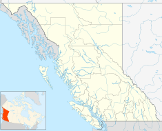
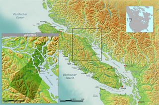
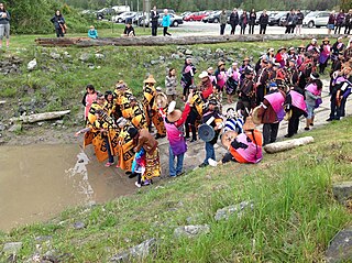
Fort Langley is a village community in Township of Langley, British Columbia, Canada. It has a population of approximately 3,400 people. It is the home of Fort Langley National Historic Site, a former fur trade post of the Hudson's Bay Company. Lying on the Fraser River, Fort Langley is at the northern edge of the Township of Langley.

<span class="mw-page-title-main">Laich-kwil-tach</span>

Laich-kwil-tach, is the Anglicization of the Kwak'wala autonomy by the "Southern Kwakiutl" people of Quadra Island and Campbell River in British Columbia, Canada. There are today two main groups : the Wei Wai Kai and Wei Wai Kum just across on the Vancouver Island "mainland" in the town of Campbell River. In addition to these two main groups there are the Kwiakah originally from Phillips Arm and Frederick Arm and the Discovery Islands, the Tlaaluis (Laa'luls) between Bute and Loughborough Inlets—after a great war between the Kwakiutl and the Salish peoples they were so reduced in numbers that they joined the Kwiakah—and the Walitsima / Walitsum Band of Salmon River.

<span class="mw-page-title-main">Fort Nez Percés</span> Fur trading post in Washington Territory

Fort Nez Percés, later known as (Old) Fort Walla Walla, was a fortified fur trading post on the Columbia River on the territory of modern-day Wallula, Washington. Despite being named after the Nez Perce people, the fort was in the traditional lands of the Walla Walla. Founded in 1818 by the North-West Company, after 1821 it was run by the Hudson's Bay Company until its closure in 1857.

<span class="mw-page-title-main">Fort Okanogan</span> United States historic place

Fort Okanogan was founded in 1811 on the confluence of the Okanogan and Columbia Rivers as a fur trade outpost. Originally built for John Jacob Astor’s Pacific Fur Company, it was the first American-owned settlement within Washington state, located in what is now Okanogan County. The North West Company, the PFC's primary competitor, purchased its assets and posts in 1813. In 1821 the North West Company was merged into Hudson's Bay Company, which took over operation of Fort Okanogan as part of its Columbia District. The fort was an important stop on the York Factory Express trade route to London via Hudson Bay.

<span class="mw-page-title-main">Kwantlen First Nation</span> Indigenous reserve in British Columbia, Canada

Kwantlen First Nation is a First Nations band government in British Columbia, Canada, located primarily on McMillan Island near Fort Langley. The Kwantlen people traditionally speak hən̓q̓əmin̓əm̓, the Downriver dialect of Halkomelem, one of the Salishan family languages.

<span class="mw-page-title-main">James McMillan (fur trader)</span> Canadian fur trader and explorer

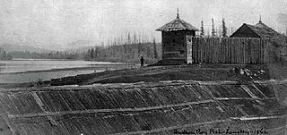
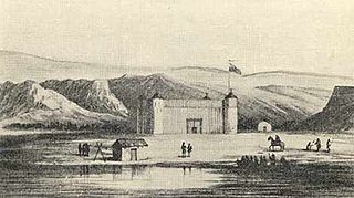
James McMillan was a fur trader and explorer for the North West Company and Hudson's Bay Company. He led some of the earliest surveys of the lower Fraser River and founded Fort Langley for the HBC in 1827, and was its first Chief Trader.

McMillan Island is an island in the Fraser River, British Columbia, Canada, also known as McMillan Slough..

<span class="mw-page-title-main">Coast Salish</span> Indigenous people of the Pacific Northwest Coast of North America

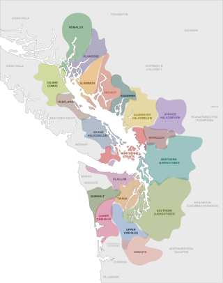
The Coast Salish are a group of ethnically and linguistically related Indigenous peoples of the Pacific Northwest Coast, living in the Canadian province of British Columbia and the U.S. states of Washington and Oregon. They speak one of the Coast Salish languages. The Nuxalk nation are usually included in the group, although their language is more closely related to Interior Salish languages.

<span class="mw-page-title-main">Tsawwassen First Nation</span> First Nations government in the Greater Vancouver area, Canada

The Tsawwassen First Nation is a First Nations government whose lands are located in the Greater Vancouver area of the Lower Mainland of British Columbia, Canada, close to the South Arm of the Fraser River and just north of the international boundary with the United States at Point Roberts, Washington. Tsawwassen First Nation lists its membership at 491 people, nearly half of whom live on the lands.

<span class="mw-page-title-main">James Murray Yale</span> Canadian merchant (1798–1871)

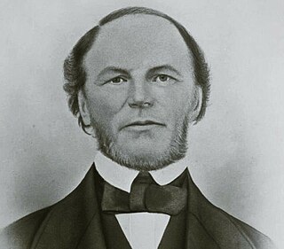
James Murray Yale was a clerk, and later, a Chief trader for the Hudson's Bay Company, during the late North American fur trade, as they were competing with the Montreal-based North West Company and the American Fur Company of John Jacob Astor. During his career, he would negotiate and compete with Americans, French Canadians, Russians, and Indians for market shares. He is best remembered for having given his name to Fort Yale, British Columbia, which became the city of Yale during the gold rush, and later on, became the name of the Yaletown district of downtown Vancouver.

Fort McLoughlin was a fur trading post established in 1833 by the Hudson's Bay Company (HBC) on Campbell Island in present-day British Columbia, Canada. At the time the Hudson's Bay Company performed quasi-governmental duties on behalf of the British Empire as well as undertaking trade for profit. The site is believed to have been at McLoughlin Bay on the northeast side of Campbell Island and is associated with the relocation of the Heiltsuk community of Bella Bella from its former location on islets near Denny Island. The McLoughlin name, which is that of John McLoughlin, regional head of company operations at that time, is also found in a lake and a creek entering that bay, and was conferred on these locations after the fort had closed.

<span class="mw-page-title-main">Katzie First Nation</span> First Nation government in Canada

The Katzie First Nation or Katzie Nation is the band government of the Katzie people of the Lower Fraser Valley region of British Columbia, Canada.

Fort Simpson was a fur trading post established in 1831 by the Hudson's Bay Company (HBC) near the mouth of the Nass River in present-day British Columbia, Canada. In 1834, it was moved to the Tsimpsean Peninsula, about halfway between the Nass River and the Skeena River, and was later referred to as Port Simpson or as the native name Lax Kw'alaams. The fort was part of the HBC's Columbia Department.

Glover Road is a primary road in Langley, British Columbia which runs from southwest to northeast North-South from the Fraser Highway in downtown Langley to the Fraser River in Fort Langley, travelling over British Columbia Highway 1 and through the community of Milner, British Columbia. The road is 11 km (7 mi) in length and mostly two lanes wide with some divided four lane sections. It is notable as the primary road in and to the village of Fort Langley and as being concurrent for some of its length with British Columbia Highway 10. Beyond Fort Langley, it crosses the Jacob Haldi Bridge onto McMillan Island and terminates at the decommissioned Albion Ferry dock within the lands of the Kwantlen First Nation. The Glover Road overpass is a six-span, two-lane structure permitting access across Trans-Canada Highway. The underpass received an overheight-warning system, the second in the province, following damage from three collisions in three years.

References

  1. 1 2 3 4 5 6 7 8 "Fort Langley National Historic Site of Canada". Canada's Historic Places. Parks Canada. Retrieved 24 January 2021.
  2. Lepofsky, Dana; Schaepe, David M.; Graesch, Anthony P.; Lenert, Michael; Ormerod, Patricia; Carlson, Keith Thor; Arnold, Jeanne E.; Blake, Michael; Moore, Patrick; Clague, John J. (October 2009). "Exploring Stó:Lō-Coast Salish Interaction and Identity in Ancient Houses and Settlements in the Fraser Valley, British Columbia". American Antiquity. 74 (4): 595–626. doi:10.1017/s0002731600048988. ISSN   0002-7316. S2CID   147387649.
  3. 1 2 Carmichael, David L; Hubert, Jane; Reeves, Brian; Schanche, Audhild, eds. (1994-06-16). Sacred Sites, Sacred Places. doi:10.4324/9780203714041. ISBN   9780203714041.
  4. 1 2 Carlson, Keith (1997). You Are Asked To Witness: The Sto:lo In Canada's Pacific Coast History. Chilliwack, British Columbia, Canada: Sto:lo Heritage Trust. pp. 58–59. ISBN   0-9681577-2-6.
  5. 1 2 3 4 5 6 7 Cullen, Mary K. The History of Fort Langley, 1927-96. Canadian Historical Site: Occasional Papers in Archeology & History, 1972.
  6. Maclachlan, Morag (November 1, 2011). "Journal Kept by George Barnston, 1827-8". Fort Langley Journals, 1827-30. UBC Press. p. 23. ISBN   978-0774841979.
  7. First Fort Langley National in The Langley Story Illustrated
  8. Nikolaus, Henry (2005). "Iwówes: A Community Profile and History" (PDF). Stó:lo Research and Resource Management Centre. Retrieved March 2, 2020.
  9. 1 2 3 4 5 6 7 8 9 10 11 Sage, Walter N. Life at a Fur Trading Post in British Columbia a Century Ago. The Washington Historical Quarterly 25, No. 1 (1934), pp. 11-22
  10. 1 2 Harris, Cole. The Resettlement of British Columbia. 1997
  11. Brown, K. L. (2010). Highliners and Moneymakers: Understanding Accommodation and Resistance in the Sto: lo Commercial Fishery. New Proposals: Journal of Marxism and Interdisciplinary Inquiry, 3(3), 20-31.
  12. Eisenberg, Avigail; Eisenberg, Associate Professor of Political Science Avigail (2009-08-27). Reasons of Identity: A Normative Guide to the Political and Legal Assessment of Identity Claims. OUP Oxford. ISBN   978-0-19-929130-4.
  13. Peak Production at Fort Langley Archived 2007-02-23 at the Wayback Machine , Parks Canada]
  14. "Kwantlen of the Coast Salish: A Halkomelem tribe". Surrey History. 2014. Retrieved March 2, 2020.
  15. Menzies, Charles R. (2006). Traditional Ecological Knowledge and Natural Resource Management. U of Nebraska Press. ISBN   978-0-8032-0735-6.
  16. "Fort Langley National Historic Site". www.pc.gc.ca. Parks Canada. 26 November 2019. Retrieved 7 January 2022.
  17. Fort Langley . Canadian Register of Historic Places . Retrieved 27 November 2011.
  18. Fatur, Miranda (12 April 2019). "Students unveil art project that honours Kwantlen First Nation". Langley Advance Times. Retrieved 3 March 2020.
  19. 1 2 3 4 5 6 Fort Langley National Historic Site of Canada Management Plan (PDF). Parks Canada. November 2005. ISBN   0-662-38454-7 . Retrieved 24 January 2021.
  20. 1 2 3 "Storehouse". Canada's Historic Places. Parks Canada. Retrieved 24 January 2021.
  21. 1 2 3 4 5 "Northeast Bastion". Canada's Historic Places. Parks Canada. Retrieved 24 January 2021.
  22. 1 2 "Big House". Canada's Historic Places. Parks Canada. Retrieved 24 January 2021.
  23. "Servants' Quarters". Canada's Historic Places. Parks Canada. Retrieved 24 January 2021.