Billy Frank Jr. Nisqually National Wildlife Refuge

Last updated
Billy Frank Jr. Nisqually National Wildlife Refuge
IUCN category IV (habitat/species management area)
Nisqually NWR 28077.JPG
USA Washington location map.svg
Red pog.svg
Location in Washington state
Location Thurston and Pierce counties, Washington, USA
Nearest city Lacey, WA
Coordinates 47°04′57″N122°43′18″W / 47.08250°N 122.72167°W / 47.08250; -122.72167 [1]
Area4,529.21 acres (18.3291 km2) [3]
Established1974 (1974) [4]
Named for Billy Frank, Jr.
Visitors137,000(in 2004)
Governing body United States Fish and Wildlife Service
Website Billy Frank Jr. Nisqually NWR

The Billy Frank Jr. Nisqually National Wildlife Refuge is a wildlife preserve operated by the United States Fish and Wildlife Service on the Nisqually River Delta near Puget Sound in northeastern Thurston County, Washington and northwestern Pierce County, Washington. The refuge is located just off Interstate 5, between the cities of Tacoma and Olympia.

Contents

History

Treaty Tree where the Treaty of Medicine Creek was signed Medicine Creek Treaty Tree.jpg
Treaty Tree where the Treaty of Medicine Creek was signed

Background

The oral history of the Nisqually describes the Nisqually basin as the point of origin of their people. Their endonym, dxʷsqʷaliʔabš, 'people of the grass', comes from the grasses that grew in the basin. The delta was relied upon to provide sustenance and the food sources were abundant enough for 14 permanent villages and a seasonal economy. Salmon was caught via a variety of techniques and the people were able to hunt a diverse array of wildlife, including various species of waterfowl, game, and sea mammals. The grass and woodlands in the area were used to gather seasonal fruits such as berries, grow crops such as camas, and provide timber for the construction of weirs and canoes. The Nisqually practiced cultural burning and, through managed modification, created a sustainable habitat for millenniums. [5]

In the 1830s, a fort was built near the Nisqually basin and fur trading began in earnest, leading to the loss of beaver dams and the natural wetlands. Yearning for more economic diversity, ranching began in 1839, and severe grazing damages led to a growth of trees on the prairies. By the 1850s, farmers and missionaries began migrating to the area, demanding for the Nisqually to be relinquished of their lands. The Medicine Creek Treaty was signed in 1854 and the signatory tribes, though given the right to fish, were removed to reservations, ceding all other lands under the treaty to the federal government. A brief armed conflict, known as the Puget Sound War, resulted over dissatisfaction with the treaty, but ended due to a combination of the execution of Leschi (one of the leaders on the Native side) and federal expansion of the lands conveyed under the treaty. [5]

A transcontinental railroad was introduced to the area in 1883, and with it an increase in migration, logging, and large-scale agriculture. The timber production, due to erosion and increase to water temperatures, decimated the salmon habitat. Land reclamation was increased due to needs for farming. The building of dikes also became another cause in the decrease to the aquatic ecosystem. By the 1910s, local power companies began constructing dams on the Nisqually River, further destroying salmon spawning and migration. Despite an attempt in the 1950s that added fish ladders and other modes of opportunity for salmon to swim around the dams, one line of Chinook salmon was declared extinct. [5]

Creation

A large port was planned beginning in 1965 that would have filled the basin. The depth and openness of the basin was considered desireable, but community efforts involving numerous groups (including the Nisqually people, environmental groups, and local landowners) blocked the build. A state department, known at the time as the Department of Game, slowly began buying up hundred-acre parcels in the valley and they entered into a partnership with the Nisqually Tribe to combat the creation of the port. By 1970, widespread support against the port was reported and such organizations as the Nisqually Delta Association and Nisqually River Task Force were formed to study the watershed and its critical status as a necessary habitat. Reports from the studies showed that the port would be a catastrophic detriment to the already decimated valley and proposals, quickly adopted, were outlined to repair the Nisqually basin. Protections of the estuaries, upstream habitats, and Nisqually tribal right were emphasized and no port would be built. Further studies called for the land to be protected under a federal wildlife refuge, though proposals allowed for continued farming of the valley and upstream logging but with more stringent rules. [5]

The 12.6 km2 refuge was created in January 1974 after the purchase of a large farm. Additional large tracts were purchased, or planned to be added. Further court cases solidified the Nisqually tribal fishing rights and that the state "had a legal obligation to protect salmon habitat". [5]

The refuge is to provide habitat and nesting areas for waterfowl and other migratory birds. It includes a protected estuary, salt marshes and open mudflats, freshwater marshes, open grassland, and riparian woodland and brush. An additional 3.2 square kilometres (1.2 sq mi) is protected by the disjoint Black River Unit on a tributary of the Chehalis River. Local environmentalist Margaret McKenny is attributed for the preservation of this area.

On December 18, 2015, President Barack Obama signed the Billy Frank Jr. Tell Your Story Act into law, redesignating the wildlife refuge in honor of Nisqually tribe leader and treaty rights activist Billy Frank, Jr.. [6] [7] [8] Frank, who died in 2014, had been arrested approximately 50 times during protests against the port build, as well as for Nisqually tribal rights, in the 1960s and 1970s, also was a central figure in restoration efforts. [5] The bill also established the Medicine Creek Treaty National Memorial within the refuge to commemorate the Treaty of Medicine Creek. [9] The national memorial is where the treaty was signed at the Treaty Tree, which is only accessible by boat up McAllister Creek. [10]

Restoration

State legislation enacted early attempts at restoration of the watershed in the mid-1980s, creating the Nisqually River Management Plan and Nisqually River Council. The power companies agreed to proper flow rates as well as the creation of the Clear Creek hatchery. In the 1990s, additional lands surrounding the Nisqually valley were purchased and added to the refuge as a buffer against encroaching residential growth. Tidelands began to be restored, starting in 1996, and culminating in 2009 with hundreds of acres of habitat, including the revival of 50% of salt marsh areas, restored. Large dikes were removed, and additional protections were taken on upstream rivers, lands, and valleys. [5]

Wildlife

The wildlife refuge is home to the Nisqually River Delta, which has the unique status as Washington's largest relatively undisturbed estuary. The confluence of the freshwater Nisqually River and the saltwater south Puget Sound has created a variety of unique environments, each rich in nutrients and natural resources for the local wildlife. The delta provides habitats for more than 300 different species of fish and wildlife. [11]

In 1904 the Brown Farm Dike, five miles long, was created to protect farmland from tidal surge, resulting in a loss of important habitat for young fish, birds and marine mammals such as harbor seals. [5] As part of a long running project to restore the estuary, in 2009, a new 10,000 foot dike was installed behind the old dike and four miles of the old Brown Farm Dike were removed. This enabled the tidal flows to reclaim 762 acres to the estuary. [5]

Sea life features 24 species of fish located in one of three habitats: riverine, estuarine, or the Nisqually Reach nearshore. Large populations of fall Chinook salmon, starry flounder and shiner perch offer a sampling of the fish that are abundantly available. [12] The saltmarshes and mudflats are located outside of the dikes. Rich in nutrients, they are the home to clams, crabs, shrimp and worms, which in turn feed ducks, gulls and herons. Over 20,000 birds, made up of 275 different migrating species, use the freshwater marshes and grasslands for breeding, resting or wintering. The most abundant bird types include raptors, shorebirds and songbirds. Larger animals such as hawks and coyotes feast in the grassland due to the presence of mice and voles. The riparian woodland and brush habitats contain many amphibians, mammals and reptiles.

See also

Related Research Articles

<span class="mw-page-title-main">Chehalis River (Washington)</span> River in Washington state, United States

The Chehalis River is a river in Washington in the United States. It originates in several forks in southwestern Washington, flows east, then north, then west, in a large curve, before emptying into Grays Harbor, an estuary of the Pacific Ocean. The river is the largest solely contained drainage basin in the state.

<span class="mw-page-title-main">Squaxin Island Tribe</span> Native American tribe in Washington, United States

The Squaxin Island Tribe are the descendants of several Lushootseed clans organized under the Squaxin Island Indian Reservation, a Native American tribal government in western Washington state.

Nisqually, Niskwalli, or Nisqualli may refer to:

The Nisqually are a Lushootseed-speaking Native American tribe in western Washington state in the United States. They are a Southern Coast Salish people. They are federally recognized as the Nisqually Indian Tribe, formerly known as the Nisqually Indian Tribe of the Nisqually Reservation and the Confederated Tribes of the Chehalis Reservation.

<span class="mw-page-title-main">Puyallup River</span> River in Washington, United States

The Puyallup River is a river in the U.S. state of Washington. About 45 miles (72 km) long, it is formed by glaciers on the west side of Mount Rainier. It flows generally northwest, emptying into Commencement Bay, part of Puget Sound. The river and its tributaries drain an area of about 948 square miles (2,460 km2) in Pierce County and southern King County.

<span class="mw-page-title-main">Nisqually River</span> River in Washington, United States

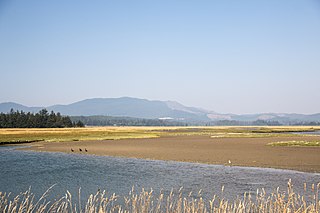
The Nisqually River is a river in west central Washington in the United States, approximately 81 miles (130 km) long. It drains part of the Cascade Range southeast of Tacoma, including the southern slope of Mount Rainier, and empties into the southern end of Puget Sound. Its outlet was designated in 1971 as the Nisqually Delta National Natural Landmark.

Puget Sound salmon recovery is a collective effort of federal, state and local authorities and non-profit coalitions of universities, scientists, business and industry aimed at restoring Pacific salmon and anadromous forms of Pacific trout (Oncorhynchus) within the Puget Sound region. The Puget Sound lies within the native range of the Pacific Salmon (Oncorhynchus) and two sea-run forms of Pacific trout, the coastal rainbow trout or steelhead and coastal cutthroat trout. Populations of Oncorhynchus have seen significant declines since the middle of the 19th century due to over fishing, habitat loss, pollution and disease. Salmon species residing in or migrating through the Puget Sound to spawning streams include Chum, Coho, Chinook, Sockeye, and Pink salmon. Pacific salmon require freshwater rivers for spawning and most major tributaries of the Puget Sound have salmon, steelhead and cutthroat trout spawning runs.

<span class="mw-page-title-main">Humboldt Bay</span> Bay on the North Coast of California

Humboldt Bay is a natural bay and a multi-basin, bar-built coastal lagoon located on the rugged North Coast of California, entirely within Humboldt County, United States. It is the largest protected body of water on the West Coast between San Francisco Bay and Puget Sound, the second-largest enclosed bay in California, and the largest port between San Francisco and Coos Bay, Oregon. The largest city adjoining the bay is Eureka, the regional center and county seat of Humboldt County, followed by the city of Arcata. These primary cities, together with adjoining unincorporated communities and several small towns, comprise a Humboldt Bay Area with a total population of nearly 80,000 people. This comprises nearly 60% of the population of Humboldt County. The bay is home to more than 100 plant species, 300 invertebrate species, 100 fish species, and 200 bird species. In addition, the bay and its complex system of marshes and grasses support hundreds of thousands of migrating and local shore birds. Commercially, this second-largest estuary in California is the site of the largest oyster production operations on the West Coast, producing more than half of all oysters farmed in California.

<span class="mw-page-title-main">Ankeny National Wildlife Refuge</span>

Ankeny National Wildlife Refuge is located in the fertile Willamette Valley of northwestern Oregon, 12 miles (19 km) south of Salem. The valley was once a rich mix of wildlife habitats. Valley wetlands were once extensive, with meandering stream channels and vast seasonal marshes. Today, the valley is a mix of farmland and growing cities, with few areas remaining for wildlife.

The Treaty of Medicine Creek was an 1854 treaty between the United States, and nine tribes and bands of Indians, occupying the lands lying around the head of Puget Sound, Washington, and the adjacent inlets. The tribes listed on the Treaty of Medicine Creek are Nisqually, Puyallup, Steilacoom, Squawskin, S'Homamish, Stehchass, T'Peeksin, Squi-aitl, and Sa-heh-wamish. The treaty was signed on December 26, 1854, by Isaac I. Stevens, governor and superintendent of Indian Affairs of the territory at the time of the signing, along with the chiefs, head-men and delegates of the stated tribes. For the purpose of the treaty, these representatives who signed the treaty were stated to have been, "regarded as one nation, on behalf of said tribes and bands, and duly authorized by them."

The Oregon Coast National Wildlife Refuge Complex consists of six National Wildlife Refuges along the Oregon Coast. It provides wilderness protection to thousands of small islands, rocks, reefs, headlands, marshes, and bays totaling 371 acres spanning 320 miles (515 km) of Oregon's coastline. The areas are all managed by the United States Fish and Wildlife Service.

<span class="mw-page-title-main">Bandon Marsh National Wildlife Refuge</span>

Bandon Marsh National Wildlife Refuge is a U.S. National Wildlife Refuge on Oregon's coast. It is one of six National Wildlife Refuges comprising the Oregon Coast National Wildlife Refuge Complex and is renowned among bird watchers for being able to view rare shorebirds including ruff, Hudsonian godwit, and Mongolian plover. The refuge was last expanded in 1999, it now has 889 acres (3.60 km2) in two units: Bandon Marsh and Ni-les'tun.

<span class="mw-page-title-main">Fir Island</span> Island in Washington, United States

Fir Island is bounded by North and South Forks of the Skagit River and Skagit Bay of Puget Sound in the southwestern corner of Skagit County, Washington. Triangular in outline, 5.3 miles (8.5 km) east–west by 6.5 miles (10.5 km) north–south with an area of nearly 9,900 acres (40 km2), Fir Island is occupied by 195 families. The island is connected by bridge to the village of Conway, located on the east shore of the South Fork of the Skagit River. A second bridge, across the North Fork of the Skagit River, leads to La Conner, 3.7 miles (6.0 km) northwest. Near the northeast tip of Fir Island is the site of the 19th-century town of Skagit City which declined after upstream log jams were removed in 1877.

<span class="mw-page-title-main">San Pablo Bay National Wildlife Refuge</span> Protected area in California, United States

San Pablo Bay National Wildlife Refuge is a 13,190-acre (53.4 km2) National Wildlife Refuge in California established in 1970. It extends along the northern shore of San Pablo Bay, from the mouth of the Petaluma River, to Tolay Creek, Sonoma Creek, and ending at Mare Island.

<span class="mw-page-title-main">Billy Frank Jr.</span> Native American rights activist

Billy Frank Jr. was a Native American environmental leader and advocate of treaty rights. As a member of the Nisqually tribe, Frank led a grassroots campaign in the 1960s and 1970s to secure fishing rights on the Nisqually River, located in Washington state. His efforts centered around promoting cooperative management of natural resources. Frank served as the chairman of the Northwest Indian Fisheries Commission for over thirty years.

<span class="mw-page-title-main">Julia Butler Hansen Refuge for the Columbian White-Tailed Deer</span> Wildlife refuge in southwestern Washington and northwestern Oregon, US

Located in southwestern Washington and northwestern Oregon, United States, the Julia Butler Hansen Refuge for the Columbian White-Tailed Deer is a wildlife refuge. It was established in 1972 specifically to protect and manage the endangered Columbian white-tailed deer. The refuge contains over 5,600 acres (23 km2) of pastures, forested tidal swamps, brushy woodlots, marshes, and sloughs along the Columbia River in both Washington and Oregon.

The Fish Wars were a series of civil disobedience protests by Native American tribes in the Pacific Northwest region of the United States during the 1960s and 1970s. These protests, coordinated by tribes around the Puget Sound, pressured the U.S. government to recognize fishing rights granted by the Treaty of Medicine Creek. They protested by continuing to fish on their land while risking charges being pressed against them.

Leque Island is a small island located in Snohomish County, in Washington, United States. It can be found just beneath the bridge between Camano Island and Stanwood, at the mouth of the Stillaguamish River, in Puget Sound.

<span class="mw-page-title-main">South Puget Sound</span> Region in Washington, United States

South Puget Sound is the southern reaches of Puget Sound in Southwest Washington, in the United States' Pacific Northwest. It is one of five major basins encompassing the entire Sound, and the shallowest basin, with a mean depth of 37 meters (121 ft). Exact definitions of the region vary: the state's Department of Fish and Wildlife counts all of Puget Sound south of the Tacoma Narrows for fishing regulatory purposes. The same agency counts Mason, Jefferson, Kitsap, Pierce and Thurston Counties for wildlife management. The state's Department of Ecology defines a similar area south of Colvos Passage.

<span class="mw-page-title-main">Sitka Sedge State Natural Area</span> Natural area in Tillamook County, Oregon, United States

Sitka Sedge State Natural Area is an estuary and beach on the north coast of the U.S. state of Oregon in Tillamook County. Sitka Sedge consists of 357 acres (144 ha) of tidal marsh, mudflats, dunes, forested wetlands, and uplands at the south end of the Sand Lake estuary, north of Tierra Del Mar.

References

  1. "Nisqually National Wildlife Refuge". Geographic Names Information System . United States Geological Survey, United States Department of the Interior.
  2. "Nisqually National Wildlife Refuge". Geographic Names Information System . United States Geological Survey, United States Department of the Interior.
  3. "Annual Report of Lands as of September 30, 2013" (PDF). United States Fish and Wildlife Service.
  4. "About the Refuge". Nisqually National Wildlife Refuge. U.S. Fish and Wildlife Service.
  5. 1 2 3 4 5 6 7 8 9 Norberg, David (November 23, 2018). "Billy Frank Jr. Nisqually National Wildlife Refuge and the Nisqually River Watershed". HistoryLink. Retrieved April 23, 2024.
  6. "Statement by the Press Secretary on H.J.Res. 76, H.R. 2270, H.R. 2297, H.R. 2693, H.R. 2820, H.R. 3594, H.R. 3831, H.R. 4246, S. 614, S. 808, S. 1090 and S. 1461". whitehouse.gov (Press release). December 18, 2015. Retrieved December 26, 2015 via National Archives.
  7. "Nisqually wildlife refuge to be renamed for activist Billy Frank Jr". The Seattle Times . December 14, 2015. Retrieved December 26, 2015.
  8. Connelly, Joel (December 14, 2015). "Senate passes legislation to rename Nisqually Wildlife Refuge for Billy Frank Jr". Seattle Post-Intelligencer . Retrieved December 26, 2015.
  9. "Billy Frank Jr., Tell Your Story". U.S. Fish and Wildlife Service. Retrieved 2019-03-26.
  10. "Billy Frank Jr. Nisqually National Wildlife Refuge" (PDF).
  11. "Habitat". Nisqually National Reserve. U.S. Fish and Wildlife Service. Retrieved February 25, 2015.
  12. "Fish". Nisqually National Reserve. U.S. Fish and Wildlife Service. Retrieved February 25, 2015.