
Deception Pass is a strait separating Whidbey Island from Fidalgo Island, in the northwest part of the U.S. state of Washington. It connects Skagit Bay, part of Puget Sound, with the Strait of Juan de Fuca. A pair of bridges known collectively as Deception Pass Bridge cross Deception Pass. The bridges were added to the National Register of Historic Places in 1982.

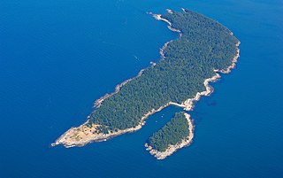
Sucia Island is located 2.5 miles (4.0 km) north of Orcas Island in the San Juan Islands, San Juan County, Washington, United States. It is the largest of an archipelago of ten islands including Sucia Island, Little Sucia, Ewing, Justice, Herndon, the Cluster Islands islets, and several smaller, unnamed islands. The group of islands is about 2.5 miles (4.0 km) in length and just short of a half mile wide. Sucia island is roughly the shape of a hand. The total land area of all islands is 2.74 km2. The main island of Sucia Island by itself is 2.259 km2. There was a permanent population of four persons as of the 2000 census, all on Sucia Island. Sucia Island State Park is a Washington State Marine Park.

Battle Ground Lake State Park is a 275-acre (111 ha) public recreation area located three miles (4.8 km) northeast of the city of Battle Ground, Washington. The state park is covered by an evergreen forest located around a crater lake of volcanic origin. The park is managed by the Washington State Parks and Recreation Commission.

Moran State Park is a public recreation area on Orcas Island in Puget Sound's San Juan Islands in the state of Washington, United States. The state park encompasses over 5,000 acres of various terrain including forests, wetlands, bogs, hills, and lakes. It is the largest public recreation area in the San Juan Islands and the fourth largest state park in the state. A park focal point is the observation tower atop Mount Constitution, the highest point in San Juan County at 2,407 feet.
Jones Island State Park is a Washington state park coterminous with Jones Island, one of the San Juan Islands in San Juan County, Washington, USA. It is located one mile (1.6 km) west of the southwestern corner of Orcas Island and accessible only by boat. The island has a land area of 188 acres (76 ha) and no resident population. The island was named by the Wilkes Expedition in 1841 for naval officer Jacob Jones.

Harstine Island is an island in Mason County, Washington, United States. The US Census recognizes it as an unincorporated community. The island is located west of Case Inlet in southern Puget Sound, 16 km (9.9 mi) north of Olympia. It has a land area of 48.305 km2 (18.651 sq mi), and had a population of 1,412 as of the 2010 census.
Patos Island is a small island in the San Juan Islands of the U.S. state of Washington. Since 1893, it has been home to the Patos Island Lighthouse, guiding vessels through Boundary Pass between Canada and the United States. The name comes from the Spanish pato, meaning "duck," which was given to the island in 1792 by Commander Dionisio Alcalá Galiano of the Sutil and Captain Cayetano Valdés y Flores of the Mexicana.

Potlatch State Park is a 57-acre (23 ha) Washington state park located on Hood Canal near the town of Potlatch in Mason County. The park offers camping, hiking, boating, fishing, shellfish harvesting, beachcombing, and sailboarding.

Cutts Island State Park is a public recreation area park comprising the entirety of two-acre (0.81 ha) Cutts Island in Carr Inlet in Pierce County, Washington. The island is a clay butte with a stand of trees and a teardrop-shaped beach at low tide. It sits one half-mile offshore from Kopachuck State Park and is accessible only by water and occasionally by sandbar at extremely low tide. Eight mooring buoys are available for boaters. Park activities include beachcombing and scuba diving.
Eagle Island State Park is a public recreation area in south Puget Sound occupying the entirety of Eagle Island in Pierce County, Washington. The five-acre (2.0 ha) island sits in Balch Passage between McNeil and Anderson islands about 750 feet (230 m) off Anderson Island's north shore. The island was named for Harry Eagle, one of the party members of the Wilkes Expedition of 1841.
Hope Island State Park - Skagit is a 200-acre (81 ha) Washington marine state park located on Hope Island at the northern end of Skagit Bay in Skagit County. The island has primitive campsites, beaches and forest with occasional meadows and rock outcroppings, and a trail across the island. Five mooring buoys are found on the island's northern flank. Herons nest on the southwestern end of the island. Significant cliffs surround most of the island, making getting inland a challenge.
Jarrell Cove State Park is a Washington state park on Harstine Island in south Puget Sound. It consists of 67 acres (27 ha) of forest with 3,500 feet (1,100 m) of saltwater shoreline. Park activities include camping, hiking, biking, boating, scuba diving, fishing, swimming, waterskiing, clamming, crabbing, field sports, beachcombing, windsurfing, birdwatching, wildlife viewing, and horseshoes.
McMicken Island Marine State Park is a public recreation area on Harstine Island in south Puget Sound, Mason County, Washington. The state park's 222 acres (90 ha) include 11.5 acres (4.7 ha) of forested McMicken Island and 1,661 feet (506 m) of saltwater shoreline with a sheltered cove. A sand bar connects McMicken Island to Harstine Island at low tide. Park activities include hiking, boating, and harvesting shellfish. The park is administered as a satellite of Jarrell Cove State Park. It bears the name of William C. McMicken, who was Washington Surveyor General from 1873 to 1886.
Stretch Point State Park is a public recreation area occupying eight acres (3.2 ha) of land on the northern tip of Stretch Island in Mason County, Washington. The state park is only accessible by boat and is administered as a satellite of Jarrell Cove State Park.

Joseph Whidbey State Park is a 112-acre (45 ha) Washington state park in Island County, Washington with 3,100 feet (940 m) of shoreline on the Strait of Juan de Fuca in north Puget Sound. Park activities include picnicking, ADA-accessible hiking, canoeing, crabbing, beachcombing, and birdwatching. A small section of the Pacific Northwest National Scenic Trail crosses through the park.

Penrose Point State Park is a 165-acre (67 ha) Washington state park located on Mayo Cove and Carr Inlet at the southern end of Puget Sound in Pierce County. The park has over 2 miles (3.2 km) of saltwater shoreline as well as 2.5 miles (4.0 km) of hiking and biking trails and an interpretive nature trail. Park activities include picnicking, boating, scuba diving, fishing, swimming, waterskiing, clam digging, crabbing, beachcombing, birdwatching, wildlife viewing, and horseshoes. The park was named after Stephen Penrose, the president of Whitman College in Walla Walla from 1884 to 1934.

Triton Cove State Park is a public recreation covering 30 acres (12 ha) on Triton Cove at the southeastern corner of Jefferson County, Washington. The state park has 555 feet (169 m) of saltwater shoreline on Hood Canal with facilities for picnicking, docking, diving, fishing, crabbing, and shellfish harvesting.
Upright Channel Park is a former unit of the Washington State Park System consisting of 20 acres (8.1 ha) of island, beach, and tidelands on Upright Channel in the northwest corner of Lopez Island. The park was not listed as a Washington State Parks property as of March 2014. San Juan County assumed management of the property per a memorandum of understanding in May 2014.
Roger W. Wheeler State Beach is a public recreation area covering 27 acres (11 ha) on Block Island Sound in the town of Narragansett, Rhode Island. The area offers picnicking, ocean swimming, and a playground and is open seasonally.
Doe Island State Park is a public recreation area comprising the entirety of Doe Island, a seven-acre (2.8 ha) island lying some 300 feet (91 m) off the eastern flank of Orcas Island in the San Juan Islands group in San Juan County, Washington. It has 2,049 feet (625 m) of shoreline and a trail three-tenths of a mile long that circles the island. It is only accessible by water. The Washington State Parks originally acquired a portion of the island from the Bureau of Land Management in 1964 for $15.27, with a second acquisition in 1967 from the DNR at no cost.

