Quilcene, Washington

Last updated

Quilcene, Washington
Nickname: 
"Pearl of the Peninsula"
Jefferson County Washington Incorporated and Unincorporated areas Quilcene Highlighted.svg
Location of Quilcene, Washington
Coordinates: 47°49′55″N122°53′7″W / 47.83194°N 122.88528°W / 47.83194; -122.88528 [1]
Country United States
State Washington
County Jefferson
Area
  Total9.2 sq mi (23.8 km2)
  Land8.8 sq mi (22.8 km2)
  Water0.4 sq mi (1.0 km2)
Elevation
43 ft (13 m)
Population
 (2020)
  Total598
  Density65/sq mi (25/km2)
Time zone UTC-8 (Pacific (PST))
  Summer (DST) UTC-7 (PDT)
ZIP code
98376
Area code 360
FIPS code 53-56975 [2]
GNIS feature ID1524768 [3]

Quilcene is an unincorporated community and census-designated place (CDP) in Jefferson County, Washington, United States. The population was 598 at the 2020 census.

Contents

The community is located on the Olympic Peninsula at the head of Quilcene Bay, an arm of the seawater-filled glacial valley of Hood Canal. [4] Each year many visitors enjoy the panoramic views of Mount Rainier, Puget Sound and Seattle from the 2,804-foot (855 m) summit of nearby Mount Walker, the only peak facing Puget Sound that has a road to its summit. [4] The Olympic National Forest lands in Quilcene hold Douglas fir, spring-blooming Pacific rhododendrons, Oregon grape, and salal. [5] Leland Lake is located north of Quilcene.

Quilcene oysters are named after the community. [6] Quilcene has one of the largest oyster hatcheries in the world.[ citation needed ]

History

Early inhabitants of the area were the Twana people, inhabiting the length of Hood Canal, and rarely invading other tribes. [7] The name "Quilcene" comes from the Twana word /qʷəʔlsíd/, referring to a tribal group [8] and the name of an aboriginal Twana village and community on Quilcene Bay. [9] The Quilcene ("salt-water people") were a distinct band of these people. [10]

The Wilkes Expedition charted the place as "Kwil-sid" in 1841. Hampden Cottle, a logger from Maine, and several other families settled there in 1860 and eventually established a town. [11] The town was originally situated on the banks of the Quilcene River, before being moved to higher ground. [12] The economy in Quilcene was based primarily on farming and logging, and by 1880 the town had a population of 53. [11]

The Tubal Cain Mining Company in 1902 claimed that Quilcene would become the center for the smelting of iron, copper, gold, and manganese that was expected to be found in the Olympic Mountains; however, little ore was ever discovered. [11]

Circa 1910, Green's Shingle Mill was a large part of Quilcene's history. [13]

Geography

USFWS Quilcene National Fish Hatchery QuilceneUSFWSFishHatchery7 11 2010.jpg
USFWS Quilcene National Fish Hatchery

Quilcene is located in eastern Jefferson County at the north end of Quilcene Bay, an arm of Dabob Bay, which extends north from Hood Canal. The Big Quilcene River forms the southern edge of the community, and the Little Quilcene River forms the northeastern edge; both arise in the Olympic Mountains to the west and flow past the town into Quilcene Bay.

According to the United States Census Bureau, the CDP has a total area of 9.2 square miles (23.8 km2), of which 8.8 square miles (22.8 km2) are land and 0.4 square miles (1.0 km2), or 4.25%, are water. [14]

The Olympic National Forest is west and south of the community. The 2,804-foot (855 m) summit of Mount Walker, [15] 2 miles (3 km) southwest of the CDP, offers views of Mount Jupiter, Buckhorn Mountain, Mount Constance, Mount Baker and the town of Quilcene. [5]

At the southwest edge of the Quilcene CDP, at the union of the Big Quilcene River and Penny Creek, the Quilcene National Fish Hatchery has been operating since 1911. There, the US Fish and Wildlife Service raises coho salmon for on-station release and provides coho salmon eggs and fingerlings for tribal programs. [16]

Climate

Quilcene experiences an oceanic climate (Köppen climate classification Cfb) and is almost categorised as part of the Csb climate category, receiving slightly more than 30 mm (1.2 in), the threshold for Cfb inclusion.

Climate data for Quilcene
MonthJanFebMarAprMayJunJulAugSepOctNovDecYear
Record high °F (°C)64
(18)
71
(22)
78
(26)
84
(29)
91
(33)
96
(36)
100
(38)
98
(37)
99
(37)
83
(28)
74
(23)
65
(18)
100
(38)
Mean daily maximum °F (°C)45
(7)
50
(10)
56
(13)
61
(16)
67
(19)
72
(22)
77
(25)
79
(26)
73
(23)
62
(17)
51
(11)
44
(7)
61
(16)
Mean daily minimum °F (°C)31
(−1)
33
(1)
35
(2)
38
(3)
43
(6)
48
(9)
51
(11)
50
(10)
46
(8)
40
(4)
35
(2)
31
(−1)
40
(5)
Record low °F (°C)3
(−16)
5
(−15)
12
(−11)
27
(−3)
27
(−3)
34
(1)
35
(2)
38
(3)
29
(−2)
22
(−6)
5
(−15)
4
(−16)
3
(−16)
Average precipitation inches (mm)7.39
(188)
7.38
(187)
5.93
(151)
3.81
(97)
2.82
(72)
2.13
(54)
1.29
(33)
1.24
(31)
1.60
(41)
4.13
(105)
7.99
(203)
8.65
(220)
54.36
(1,382)
Source: [17]

Demographics

Historical population
CensusPop.Note
2000 591
2010 5960.8%
2020 5980.3%
US Decennial Census [1]
2020 Census [18]

As of the 2010 census, 596 people lived in 312 households in the CDP, [19] representing a population increase of 6 and a household increase of 69 over the 2000 census). With 123 children under the age of 18, 20.6% are school age or younger.

In 2000, the population density was 60.6 people per square mile (23.4/km2). There were 284 housing units at an average density of 29.1/sq mi (11.2/km2). The racial makeup of the CDP was 84.77% White, 1.18% African American, 3.55% Native American, 0.34% Asian, 0.17% Pacific Islander, 0.85% from other races, and 9.14% from two or more races. Hispanic or Latino of any race were 1.35% of the population.

In 2000, there were 243 households, out of which 27.6% had children under the age of 18 living with them, 51.9% were married couples living together, 7.8% had a female householder with no husband present, and 35.8% were non-families. 28.8% of all households were made up of individuals, and 8.2% had someone living alone who was 65 years of age or older. The average household size was 2.42 and the average family size was 2.95.

In 2000, the median income for a household in the CDP was $40,385, and the median income for a family was $45,313. Males had a median income of $36,500 versus $24,063 for females. The per capita income for the CDP was $17,335. About 11.3% of families and 15.2% of the population were below the poverty line, including 20.0% of those under age 18 and none of those age 65 or over.

Culture

The Olympic Music Festival, based in Quilcene for 32 years until 2016, is a casual classical music event featuring world-renowned musicians that was held at a turn-of-the-century dairy farm on 55 acres (220,000 m2) of farmland. The Olympic Music Festival was voted "Best Classical Music Festival" by readers of the Seattle Weekly . The music festival was founded in 1984 by Alan Iglitzin, originally intending it to be a summer home for the Philadelphia String Quartet. [20] The festival moved to nearby Fort Worden in 2016.

Notable people

See also

Related Research Articles

<span class="mw-page-title-main">Jefferson County, Washington</span> County in Washington, United States

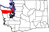
Jefferson County is a county located in the U.S. state of Washington. As of the 2020 census, the population was 32,977. The county seat and only incorporated city is Port Townsend. The county is named for Thomas Jefferson.

<span class="mw-page-title-main">Henry County, Iowa</span> County in Iowa, United States

Henry County is a county located in the U.S. state of Iowa. As of the 2020 census, the population was 20,482. The county seat is Mount Pleasant. The county was named for General Henry Dodge, governor of Wisconsin Territory.

<span class="mw-page-title-main">Pinson, Alabama</span> City in Alabama, United States

Pinson is a city in Jefferson County near Birmingham, Alabama, United States, northwest of Center Point. As of the 2010 census, the population was 7,163.

<span class="mw-page-title-main">Village of Oak Creek, Arizona</span> Community in Yavapai County, Arizona

Village of Oak Creek is an unincorporated community located within Big Park a census-designated place (CDP) in Yavapai County, Arizona, United States. The population was 6,147 at the 2010 census, up from 5,245 in 2000. Big Park is the name of the CDP while the community is more commonly known as the Village of Oak Creek (VOC), and is a bedroom community for Sedona, located seven miles away. Tourism and service to retirees and second-home owners are the basis for the local economy. Big Park, the pioneers' name for the large open area that became the Village of Oak Creek in the early 1960s, is set among scenic red-rock buttes and canyons. The Bell Rock scenic area adjoins the north end of VOC, and the town is surrounded by the Coconino National Forest. A Forest Service Visitor Center is located at the south end of VOC.

<span class="mw-page-title-main">Lagunitas-Forest Knolls, California</span> Census-designated place in California, United States

Lagunitas-Forest Knolls is a census-designated place, composed of two unincorporated areas in the western half of the San Geronimo Valley in Marin County, California. It is located to the west of San Geronimo and Woodacre. The population was 1,924 at the 2020 census.

<span class="mw-page-title-main">Valrico, Florida</span> Census-designated place in Florida, United States

Valrico is a census-designated place (CDP) in Hillsborough County, Florida, United States. As of 2020 the population was 37,895.

<span class="mw-page-title-main">Kailua-Kona, Hawaii</span> Census-designated place in Hawaii, U.S.

Kailua-Kona is an unincorporated community and census-designated place (CDP) in Hawaii County, Hawaii, United States. It’s most commonly referred to simply as Kona, but also as Kona Town, and occasionally as Kailua, thus its less frequent use. Kailua-Kona is the second-largest settlement on the island of Hawaii and the largest on the island's west side, where it is the center of commerce and the tourist industry. Kailua-Kona is served by Kona International Airport, just to the north in the adjacent CDP of Kalaoa. The population was 19,713 at the 2020 census, up from 11,975 at the 2010 census.

Fern Creek is a historic community in southeastern Jefferson County, Kentucky, United States. The population was 20,009 at the 2008 census. In 2003, The area was annexed to the city of Louisville as part of a merger between the city and Jefferson County's unincorporated communities. Fern Creek was formerly a census-designated place. It is now considered a neighborhood of Louisville. It is located about 12 miles from Downtown Louisville.

<span class="mw-page-title-main">Barataria, Louisiana</span> Census-designated place in Louisiana, United States

Barataria is a census-designated place (CDP) in Jefferson Parish, Louisiana, United States. The population was 1,057 in 2020. It is part of the New Orleans–Metairie–Kenner metropolitan statistical area.

<span class="mw-page-title-main">Murphy, Missouri</span> Census-designated place in Missouri, United States

Murphy is a census-designated place (CDP) in Jefferson County, Missouri, United States. The population was 8,690 at the 2010 census, down from 9,048 in 2000.

<span class="mw-page-title-main">Frenchtown, Montana</span> CDP in Montana, United States

Frenchtown is a census-designated place (CDP) in Missoula County, Montana, United States. It is part of the Missoula, Montana Metropolitan Statistical Area. The population was 1,825 at the 2010 census, an increase from its population of 883 in 2000.

<span class="mw-page-title-main">East Islip, New York</span> Hamlet and census-designated place in New York, United States

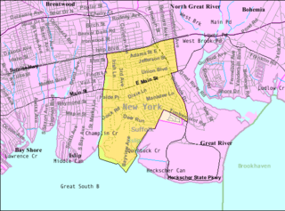
East Islip is a hamlet and CDP in the Town of Islip, Suffolk County, New York, United States. At the time of the 2010 census, the CDP had a population of 14,475.

<span class="mw-page-title-main">Livingston Manor, New York</span> CDP and hamlet in New York, United States

Livingston Manor is a hamlet in Sullivan County, New York, United States. The population was 1,053 at the 2020 census.

<span class="mw-page-title-main">Brinnon, Washington</span> Census-designated place in Washington, United States

Brinnon is a census-designated place (CDP) in Jefferson County, Washington, United States. The population was 907 at the 2020 census. The community is named for Ewell P. Brinnon, who in 1860 took a donation land claim at the mouth of the Duckabush River. Its known landmarks include Dosewallips State Park and Black Point Marina. Camp Parsons, founded in 1919 and the oldest Boy Scout camp west of the Mississippi River, sits just outside the north end of the CDP.

<span class="mw-page-title-main">Marrowstone, Washington</span> CDP in Washington, United States

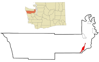
Marrowstone is a census-designated place (CDP) in Jefferson County, Washington, United States. The population was 995 at the 2020 census. All Marrowstone addresses are in Nordland, Washington, and the ZIP code for Marrowstone Island is 98358.

<span class="mw-page-title-main">Port Hadlock-Irondale, Washington</span> Census-designated place in Washington, United States

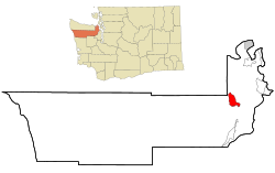
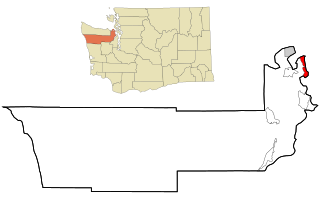
Port Hadlock-Irondale is a census-designated place (CDP) in Jefferson County, Washington, United States. The population was 3,983 at the 2020 census.

<span class="mw-page-title-main">Port Townsend, Washington</span> City in Washington, United States

Port Townsend is a city on the Quimper Peninsula in Jefferson County, Washington, United States. The population was 10,148 at the 2020 United States Census. It is the county seat and only incorporated city of Jefferson County.

<span class="mw-page-title-main">Story, Wyoming</span> CDP in Wyoming, United States

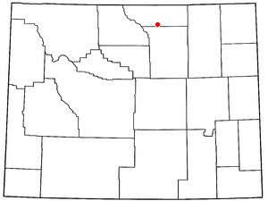
Story is a census-designated place (CDP) in Sheridan County, Wyoming, United States. As of the 2020 census, the CDP population was 903.

<span class="mw-page-title-main">Skokomish people</span> North American tribe

The Skokomish are one of nine tribes of the Twana, a Native American people of western Washington state in the United States. The tribe lives along Hood Canal, a fjord-like inlet on the west side of the Kitsap Peninsula and the Puget Sound basin. Historically the Twana were hunters, fishers, and gatherers who had a nomadic lifestyle during the warmer months, while living in more permanent homes during the winter months.

The Little Quilcene River is a river on the Olympic Peninsula in the U.S. state of Washington. It rises in Clallam County, near Mount Townsend of the Olympic Mountains.

References

  1. 1 2 "US Gazetteer files: 2010, 2000, and 1990". United States Census Bureau. February 12, 2011. Retrieved April 23, 2011.
  2. "U.S. Census website". United States Census Bureau . Retrieved January 31, 2008.
  3. "Quilcene". Geographic Names Information System . United States Geological Survey, United States Department of the Interior.
  4. 1 2 Washington Byways Guide Book, Tony Huegel, Wilderness Press, 2003, ISBN   0-89997-299-3.
  5. 1 2 Mt. Walker Trail #894, Olympic National Forest.
  6. "Scenic Driving Washington", Steve Giordano, Globe Pequot, Falcon Guides Scenic Driving, 1997, ISBN   1-56044-577-7. p. 80
  7. Twana Edward Sheriff Curtis. The North American Indian. Volume 9, 1907-1930, p.30-31
  8. Bright, William (2004). Native American Placenames of the United States. University of Oklahoma Press. p. 404. ISBN   978-0-8061-3598-4 . Retrieved September 1, 2019.
  9. Elmendorf, William (1993). Twana Narratives: Native Historical Accounts of a Coast Salish Culture. UBC Press. p. 279. ISBN   978-0-7748-0475-2 . Retrieved September 1, 2019.
  10. Hiking Adventures with Children: Southern Vancouver Island and the Olympic Peninsula, Kari Jones and Sachiko Kiyooka, Heritage House, 2005
  11. 1 2 3 "Jefferson County, Thumbnail History", HistoryLink.org Essay 7472, Daryl C. McClary, September 26, 2005, T 2007.
  12. Our Native American Legacy: Northwest Towns with Indian names, Sandy Nestor, Caxton Press, 2001, ISBN   0-87004-401-X
  13. "Winona Prill writes Quilcene heritage history book", The Port Townsend & Jefferson County Leader, Mari McGrady, May 2007.
  14. "Geographic Identifiers: 2010 Demographic Profile Data (G001): Quilcene CDP, Washington". U.S. Census Bureau, American Factfinder. Retrieved January 4, 2019.[ dead link ]
  15. "Olympic National Forest - Mt. Walker Viewpoint".
  16. Quilcene National Fish Hatchery, US Fish and Wildlife Service
  17. "weather.com - Aches & Pains - Monthly Climatology". Weather.com. August 2011. Retrieved January 23, 2011.
  18. "Census Bureau profile: Quilcene, Washington". United States Census Bureau. May 2023. Retrieved May 12, 2024.
  19. https://www.census.gov/popfinder/?fl=53:5356975 [ permanent dead link ]
  20. "Olympic Music Festival". Olympic Music Festival.