Related Research Articles
Kitsap County is located in the U.S. state of Washington. As of the 2010 census, its population was 251,133. Its county seat is Port Orchard, and its largest city is Bremerton. The county was formed out of King County and Jefferson County on January 16, 1857, and is named for Chief Kitsap of the Suquamish Tribe. Originally named Slaughter County, it was soon renamed.

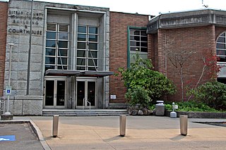
Jefferson County is a county located in the U.S. state of Washington. As of the 2010 census, the population was 29,872. The county seat and only incorporated city is Port Townsend. The county is named for Thomas Jefferson.
Marrowstone is a census-designated place (CDP) in Jefferson County, Washington, United States. The population was 844 at the 2010 census. All Marrowstone addresses are in Nordland, Washington, and the ZIP code for Marrowstone Island is 98358.

Port Hadlock-Irondale is a census-designated place (CDP) in Jefferson County, Washington, United States. The population was 3,580 at the 2010 census.

Port Ludlow is an unincorporated community and census-designated place (CDP) in Jefferson County, Washington, United States. It is also the name of the marine inlet on which the community is located. The CDP's population was 2,603 at the 2010 census, up from 1,968 at the 2000 census.

Port Townsend is a city on the Quimper Peninsula in Jefferson County, Washington, United States. The population was 9,113 at the 2010 United States Census and an estimated 9,704 in 2018. It is the county seat and only incorporated city of Jefferson County. In addition to its natural scenery at the northeast tip of the Olympic Peninsula, the city is known for the many Victorian buildings remaining from its late 19th-century heyday, numerous annual cultural events, and as a maritime center for independent boatbuilders and related industries and crafts. The Port Townsend Historic District is a U.S. National Historic Landmark District. It is also significantly drier than the surrounding region due to being in the rainshadow of the Olympic Mountains, receiving only 19 inches or 480 millimeters of rain per year.

Admiralty Inlet is a strait in the U.S. state of Washington connecting the eastern end of the Strait of Juan de Fuca to Puget Sound. It lies between Whidbey Island and the northeastern part of the Olympic Peninsula.

The Kitsap Peninsula lies west of Seattle across Puget Sound, in Washington state in the northwestern US. Hood Canal separates the peninsula from the Olympic Peninsula on its west side. The peninsula, a.k.a. "the Kitsap", encompasses all of Kitsap County except Bainbridge and Blake Islands, as well as the northeastern part of Mason County and the northwestern part of Pierce County. The highest point on the Kitsap Peninsula is Gold Mountain. The U.S. Navy's Puget Sound Naval Shipyard, and Naval Base Kitsap are on the Peninsula. Its main city is Bremerton.

Discovery Bay is a small bay connected to the Strait of Juan de Fuca on the Olympic Peninsula in Washington state; it was also historically called Port Discovery. An unincorporated community also named Discovery Bay lies in Jefferson County at the southern end of the bay.

Gardiner is an unincorporated community in Jefferson County, Washington, United States.
The Quimper Peninsula is a narrow peninsula forming the most northeastern extent of the Olympic Peninsula of Washington state in the northwestern United States of America.
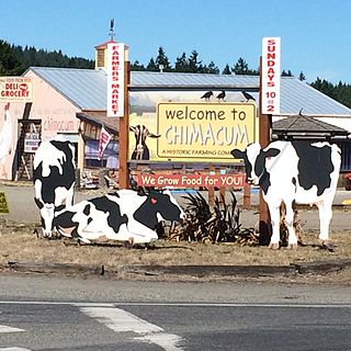
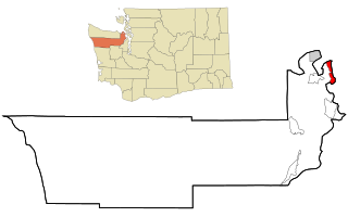
Chimacum is an unincorporated community in Jefferson County, Washington, United States, located in the center of the primary agricultural area of the eastern Olympic Peninsula. It was named after the Chimakum group of Indigenous Americans that lived there until the late 19th century but are now extinct as a distinct cultural group after losing successive conflicts with neighboring tribes.
Beckett Point is a small sand spit jutting out into northeastern Discovery Bay, about ten miles from the city of Port Townsend in Jefferson County, Washington, United States. The Point is owned by the Beckett Point Fisherman's Club, which leases out approximately 100 homes. Many of the families have lived there for several generations, fishing salmon, crab, and shrimp.
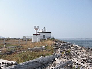
The Marrowstone Point Light is an active navigational aid overlooking Admiralty Inlet at the northern tip of Marrowstone Island, Jefferson County, Washington, in the United States. It lies adjacent to but is not part of Fort Flagler State Park; it may be viewed from the park's beach but is not open to the public.
Puget Sound Bridge and Dredging Company was a major shipbuilding and construction company, located in Seattle, Washington. The firm was established in 1898 on Elliott Bay in Puget Sound. The company was engaged in construction projects around the United States and built ships for the U.S. Navy at its shipyard on Harbor Island on Puget Sound during and after World War II. In 1959 the firm was purchased by Lockheed and became the Lockheed Shipbuilding and Construction Company. The shipyard was permanently closed in 1987.
Protection Island is an island located in the Strait of Juan de Fuca just north of Discovery Bay in northeastern Jefferson County, Washington, United States. The island has a land area of 1.534 km2. It is a federally protected National Wildlife Refuge; boats are not permitted within 200 yards for the safety and health of wildlife on and near the shores. There is only one individual still living on the island not associated with the government. Marty Bluewater has lifetime use of his inholding cabin on the island's southern bluffs. The island also houses a caretaker, a volunteer hired by the Fish and Wildlife department to watch over the island, and take care of its many inhabitants
The Port Townsend Ship Canal links Port Townsend Bay with Oak Bay in Jefferson County, Washington. Prior to construction this area was occupied by a broad sand flat and backshore marsh.

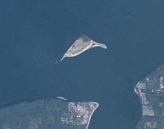
State Route 116 (SR 116) is a 9.83-mile-long (15.82 km) state highway in the U.S. state of Washington, serving Indian and Marrowstone islands in Jefferson County. The two-lane highway travels east from SR 19 in Port Hadlock-Irondale across the Portage Canal to Indian Island and Marrowstone Island, turning north and ending at the entrance to Fort Flagler State Park. SR 116 was created in 1991 and follows the route of Flagler Road, built and paved in the 1960s.
USS Boxwood (YN-3/AN-8) was an Aloe-class net laying ship which was assigned to serve U.S. Navy ships and harbors during World War II with her protective anti-submarine nets.

Fort Townsend State Park is a public recreation area located two miles south of Port Townsend in Jefferson County, Washington. The state park occupies a third of the site of the original Fort Townsend built in 1856. The park includes 3,960 feet (1,210 m) of shoreline on Port Townsend Bay, picnicking and camping areas, 6.5 miles (10.5 km) of hiking trails, and facilities for boating, fishing, and crabbing.
References
- Indian Island: Blocks 4013 thru 4037, Census Tract 9504, Jefferson County, Washington United States Census Bureau
- ↑ Does Navy depot pose a danger to public?, Seattle Times, September 11, 2011
Municipalities and communities of Jefferson County, Washington, United States | ||
|---|---|---|
| City | 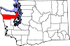 | |
| CDPs | ||
| Other unincorporated communities | ||
| Indian reservation | ||
| Ghost town | ||
| Footnotes | ‡This populated place also has portions in an adjacent county or counties | |
Coordinates: 48°03′07″N122°43′27″W / 48.05194°N 122.72417°W
Operational military installations in Washington | |||||||||||||||
|---|---|---|---|---|---|---|---|---|---|---|---|---|---|---|---|
| Army |
|  | |||||||||||||
| Navy |
| ||||||||||||||
| Air Force |
| ||||||||||||||
| National Guard |
| ||||||||||||||
| Coast Guard |
| ||||||||||||||
| Authority control |
|
|---|
| This Jefferson County, Washington state location article is a stub. You can help Wikipedia by expanding it. |