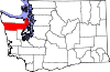
Jefferson County is a county located in the U.S. state of Washington. As of the 2020 census, the population was 32,977. The county seat and only incorporated city is Port Townsend. The county is named for Thomas Jefferson.

Port Hadlock-Irondale is a census-designated place (CDP) in Jefferson County, Washington, United States. The population was 3,983 at the 2020 census.

Port Townsend is a city on the Quimper Peninsula in Jefferson County, Washington, United States. The population was 10,148 at the 2020 United States Census. It is the county seat and only incorporated city of Jefferson County.

Quilcene is an unincorporated community and census-designated place (CDP) in Jefferson County, Washington, United States. The population was 598 at the 2020 census.

The Quinault are a group of Native American peoples from western Washington in the United States. They are a Southwestern Coast Salish people and are enrolled in the federally recognized Quinault Tribe of the Quinault Reservation.

The Skokomish are one of nine tribes of the Twana, a Native American people of western Washington state in the United States. The tribe lives along Hood Canal, a fjord-like inlet on the west side of the Kitsap Peninsula and the Puget Sound basin. Historically the Twana were hunters, fishers, and gatherers who had a nomadic lifestyle during the warmer months, while living in more permanent homes during the winter months.
The Klallam are a Coast Salish people Indigenous to the northern Olympic Peninsula. The language of the Klallam is the Klallam language, a language closely related to the North Straits Salish languages. The Klallam are today citizens of four recognized bands: Three federally-recognized tribes in the United States and one band government in Canada. Two Klallam tribes, the Jamestown S'Klallam and Lower Elwha Klallam, live on the Olympic Peninsula, and one, the Port Gamble S'Klallam, on the Kitsap Peninsula in Washington state. In Canada, the Scia'new First Nation is based at Becher Bay on southern Vancouver Island in British Columbia.

The Olympic Peninsula is a large arm of land in western Washington that lies across Puget Sound from Seattle, and contains Olympic National Park. It is bounded on the west by the Pacific Ocean, the north by the Strait of Juan de Fuca, and the east by Hood Canal. Cape Alava, the westernmost point in the contiguous United States, and Cape Flattery, the northwesternmost point, are on the peninsula. Comprising about 3,600 square miles (9,300 km2), the Olympic Peninsula contained many of the last unexplored places in the contiguous United States. It remained largely unmapped until Arthur Dodwell and Theodore Rixon mapped most of its topography and timber resources between 1898 and 1900.

The Skokomish River is a river in Mason County, Washington, United States. It is the largest river flowing into Hood Canal, a western arm of Puget Sound. From its source at the confluence of the North and South Forks the main stem Skokomish River is approximately 9 miles (14 km) long. The longer South Fork Skokomish River is 40 miles (64 km), making the length of the whole river via its longest tributary about 49 miles (79 km). The North Fork Skokomish River is approximately 34 miles (55 km) long. A significant part of the Skokomish River's watershed is within Olympic National Forest and Olympic National Park.

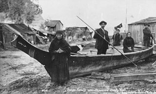
The Chimakum, also spelled Chemakum and Chimacum Native American people, were a group of Native Americans who lived in the northeastern portion of the Olympic Peninsula in Washington state, between Hood Canal and Discovery Bay until their virtual extinction in 1902. Their primary settlements were on Port Townsend Bay, on the Quimper Peninsula, and Port Ludlow Bay to the south.

Discovery Bay is an unincorporated community in Jefferson County, Washington. The community of Discovery Bay is an area near the intersection of U.S. Route 101 and State Route 20, at the foot of Discovery Bay – roughly midway between the larger communities of Port Townsend to the northeast and Sequim to the northwest. It is a mix of residential areas and commercial enterprises, including crabbing, oystering, clamming, timbering, security training and gravel extraction. A few restaurants and stores on US 101 near SR 20 primarily serve drivers and truckers along US 101.
Gardiner is an unincorporated community in Jefferson County, Washington, United States. Additionally, part of Clallam County, located along the Jefferson County line adjacent to Gardiner is often referred to as being part of Gardiner.
Little Boston is a community in Kitsap County, Washington, United States. It is located on the east side of Port Gamble, an inlet or bay of Hood Canal, and is direct across the bay from the unincorporated community of Port Gamble. Little Boston is within the Port Gamble Indian Reservation, which houses the Port Gamble band of the S'Klallam tribe.
The Point No Point Treaty was signed on January 26, 1855, at Point No Point, on the northern tip of the Kitsap Peninsula. Governor of Washington Territory, Isaac Stevens, convened the treaty council on January 25, with the S'Klallam, the Chimakum, and the Skokomish tribes. Under the terms of the treaty, the original inhabitants of northern Kitsap Peninsula and Olympic Peninsula ceded ownership of their land in exchange for small reservations along Hood Canal and a payment of $60,000 from the federal government. The treaty required the natives to trade only with the United States, to free all their slaves, and to not acquire any new slaves.

State Route 19 (SR 19) is a 14.09-mile-long (22.68 km) state highway serving rural Jefferson County on the Olympic Peninsula in the U.S. state of Washington. The highway travels from SR 104 south of Port Ludlow and travels north through Chimacum and Port Hadlock-Irondale, intersecting SR 116, to end at SR 20 southwest of Port Townsend near the Jefferson County International Airport. SR 19 was established in 1991 on a roadway that had been built in the 1950s and paved in the 1960s.
The Quimper Peninsula is a narrow peninsula forming the most northeastern extent of the Olympic Peninsula of Washington state in the northwestern United States of America.
The Twana language, also known as Skokomish, is a Coast Salish language of the Salishan language family, spoken by the Twana, the Indigenous people of Hood Canal, in Washington. It is believed by some elders within the Skokomish community that the language branched off from Lushootseed because of the region-wide tradition of not speaking the name of someone who died for a year after their death. Substitute words were found in their place and often became normalizing in the community, generating differences from one community to the next. Subiyay speculated that this process increased the drift rate between languages and separated Twana firmly from Lushootseed.
The Port Townsend Ship Canal is a 4,800-foot (1,500 m) canal connecting Port Townsend Bay and Oak Bay in Jefferson County, Washington. Built in 1915, the canal separates Indian Island from the Quimper Peninsula of mainland Washington. State Route 116 crosses the only bridge over the canal. There are no locks.
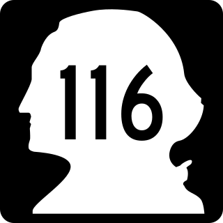
State Route 116 (SR 116) is a 9.83-mile-long (15.82 km) state highway in the U.S. state of Washington, serving Indian and Marrowstone islands in Jefferson County. The two-lane highway travels east from SR 19 in Port Hadlock-Irondale across the Portage Canal to Indian Island and Marrowstone Island, turning north and ending at the entrance to Fort Flagler State Park. SR 116 was created in 1991 and follows the route of Flagler Road, built and paved in the 1960s.
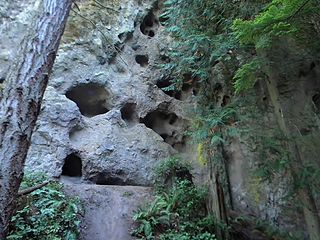
Tamanowas Rock, also called Chimacum Rock, is a 150-foot (46 m) high rock with caves and crevices that lies in a forest adjacent to Anderson Lake State Park, near Port Townsend, Washington. It is a sacred site to the Coast Salish peoples of the Pacific Northwest and a pilgrimage site. The rock was listed on the National Register of Historic Places in 2015.