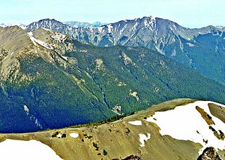
The Olympic Peninsula is a large arm of land in western Washington that lies across Puget Sound from Seattle, and contains Olympic National Park. It is bounded on the west by the Pacific Ocean, the north by the Strait of Juan de Fuca, and the east by Hood Canal. Cape Alava, the westernmost point in the contiguous United States, and Cape Flattery, the northwesternmost point, are on the peninsula. Comprising about 3,600 square miles (9,300 km2), the Olympic Peninsula contained many of the last unexplored places in the contiguous United States. It remained largely unmapped until Arthur Dodwell and Theodore Rixon mapped most of its topography and timber resources between 1898 and 1900.

Mount Anderson is a 7,330-foot-high (2,234 m) peak in the Olympic Mountains of the Pacific Northwest. Rising in the center of Olympic National Park in Washington state, it is the second highest peak on the Anderson Massif, after West Peak. Anderson Glacier used to be located in a cirque on the mountain's southern flank while Eel Glacier is in another cirque, northwest of the summit. Hanging Glacier is on the east side of a ridge which extends north from the peak.

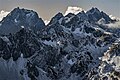
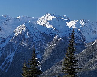
Mount Deception is a peak in the Olympic Mountains of Cascadia. It is in Olympic National Park on the Olympic Peninsula in the U.S. state of Washington.
Gray Wolf Ridge is a spur of the northeastern Olympic Mountains in Washington's Olympic Peninsula. Arcing northeast from the Mount Deception - Needles - Mount Clark - Mount Walkinshaw massif, Gray Wolf Ridge is covered by alpine and subalpine forests up to the timberline, leaving the upper elevations of the ridge's six rocky peaks vegetated only by fragile alpine meadows. The ridge and its component mountains are markedly steep, as is its primary access route, the Maynard Burn Trail (#816) of Olympic National Forest. The higher, western segment of Gray Wolf Ridge lies within the boundary of Olympic National Park.

The Buckhorn Wilderness is a 44,319-acre (17,935 ha) mountainous wilderness area on the northeastern Olympic Peninsula in Washington, USA. Named after Buckhorn Mountain, the wilderness abuts the eastern boundary of Olympic National Park which includes nearby Mount Constance, Inner Constance, Warrior Peak, and Mount Deception.

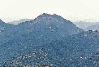
Mount Ellinor is a peak in the Olympic Mountains of Washington, United States. It is located in an area designated as the Mount Skokomish Wilderness. The mountain is a popular day hike in the summer months; the summit is reachable via a steep-but-brief 3.3-mile (5.3 km) trail which gains about 3,200 feet (980 m) in elevation from the lower trailhead.

Mount Mystery is a prominent 7,639-foot (2,328-metre) mountain summit located in the Olympic Mountains in Jefferson County of Washington state. It is located within Olympic National Park on the Olympic Peninsula. Mount Mystery is the sixth-highest peak of the Olympic Mountains, after Mount Olympus, Mount Deception, Mount Constance, Mount Johnson, and Inner Constance. Its nearest higher neighbor is Mount Deception, 1.32 mi (2.12 km) to the north-northwest. Little Mystery (6941 ft) is a subsidiary summit south of Mount Mystery.

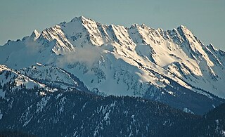
Inner Constance is a summit of the Olympic Mountains and is located in Jefferson County of Washington state. It's located near the eastern edge of Olympic National Park on the Olympic Peninsula. At 7,667 feet (2,337 m) high, Inner Constance is the fifth highest peak of the Olympic Mountains, after Mount Olympus, Mount Deception, Mount Constance, and Mount Johnson. Its nearest higher neighbor is Mount Constance, 0.9 mi (1.4 km) to the east. Within this nearly mile-wide separation resides a deep glacially carved canyon called "Avalanche Canyon". Precipitation runoff on the north side of the peak drains into tributaries of the Dungeness River, whereas the south side drains into tributaries of the Dosewallips River.

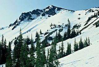
Mount Pershing is a 6,154 ft massif in the Olympic Mountains and is located in Mason County of Washington state. It is situated in the Mount Skokomish Wilderness on land managed by Olympic National Forest. The mountain's name honors General of the Armies John J. Pershing (1860–1948). The nearest higher neighbor is Mount Washington, 1.45 mi (2.33 km) to the south-southeast. Precipitation runoff drains into the Hamma Hamma River.

Warrior Peak is a 7,320+ ft double summit mountain located in Olympic National Park in Jefferson County of Washington state. Warrior is the 11th highest peak in the Olympic Mountains Range. The southeast summit is the slightly higher of the two summits, the northwest peak is estimated at 7285 feet elevation. Warrior Peak is easy to identify from Seattle, since it appears as the first prominent peak immediately north of Mount Constance, which is the dominant peak on the skyline. Warrior's nearest higher peak is in fact Mount Constance, 0.8 mi (1.3 km) to the south-southeast. The first ascent of the mountain was made in 1945 by Fred Beckey, who solo climbed both summits, and named the mountain.
West Peak is a 7,365-foot-high (2,245 m) peak in the Olympic Mountains, in Jefferson County of Washington state. Rising in the center of Olympic National Park, it is the highest peak on the Anderson Massif. West Peak is the hydrographic apex of the Olympic Mountains, with precipitation runoff flowing outward to the Pacific Ocean via Quinault River, the Strait of Juan de Fuca via Elwha River, and Hood Canal via the Dosewallips River. The Eel Glacier is situated in a cirque east of the summit, and an unnamed glacier resides in the south cirque. Its nearest higher peak is Mount Mystery, 7.73 miles (12.44 km) to the northeast. The first ascent of the peak was made in 1930 by E. B. Hamilton. Legend has it that the mountain's name is for Mr. West, a participant in the 1890 O'Neil Expedition, rather than for its apparent position on the Anderson Massif. The West Branch of the Quinault River was named after him in 1890.
Sentinel Peak is a 6,592-foot-high (2,009 m) mountain summit located in the Olympic Mountains, in Jefferson County of Washington state. Rising in the center of Olympic National Park, its nearest higher neighbor is Mount Fromme, 1.42 miles (2.29 km) to the northwest. Sentinels Sister is a lower 6,301-foot-high (1,921 m) companion summit situated 0.65 miles (1.05 km) to the southwest. The two peaks stand as sentinels above the Dosewalips Valley and Hayden Pass, and were possibly named by an early expedition of the Seattle Mountaineers. Precipitation runoff from the peak drains to Hood Canal via the Dosewallips River.

Mount Fricaba is a 7,139-foot-elevation (2,176 m) double summit mountain located in the Olympic Mountains, in Jefferson County of Washington state. It is situated on the shared border of Olympic National Park with Buckhorn Wilderness, and is the highest point in that wilderness, as well as the Olympic National Forest. Its nearest higher peak is Hal Foss Peak, 0.74 miles (1.19 km) to the southwest. Precipitation runoff from the peak drains east into headwaters of the Dungeness River, or west into Deception Creek which is a tributary of the Dosewallips River. The mountain's name was officially adopted in 1961 by the United States Board on Geographic Names based on usage by The Mountaineers since 1907, and inclusion in Fred Beckey's "Climber's Guide to the Cascade and Olympic Mountains of Washington" published in 1949. The first ascent of the mountain was made in 1957 by Don Bechlem and Jack Newman.
Mount Fairchild, also known as Mount William Fairchild, is a 6,900-foot (2,100-metre) glaciated mountain summit located within Olympic National Park in Clallam County of Washington state. Mt. Fairchild is the second-highest peak in the Bailey Range, which is a subrange of the Olympic Mountains. Its nearest higher neighbor is Mount Carrie, 0.84 mi (1.35 km) to the southwest, and Ruth Peak is set 0.92 mi (1.48 km) to the south. In clear weather, the mountain can be seen from the visitor center at Hurricane Ridge. Precipitation runoff from the mountain drains into tributaries of the Elwha River.
Mount Worthington is a 6,938-foot (2,115-metre) elevation double-summit mountain located in the eastern Olympic Mountains in Jefferson County of Washington state. It is set within Buckhorn Wilderness, on land managed by the Olympic National Forest. The nearest neighbor is Iron Mountain, 0.76 mi (1.22 km) to the southwest, and the nearest higher peak is Buckhorn Mountain, 1.3 mi (2.1 km) to the southwest. Precipitation runoff from Mount Worthington drains south into the Big Quilcene River, or north into Copper Creek which is a tributary of the Dungeness River. This mountain was first known as Copper Peak, but was renamed by Jack Christensen for the William J. Worthington family, pioneers of nearby Quilcene. Copper was mined in the Tubal Cain mine at the northern base of this mountain in the early 1900s. In the same vicinity of the abandoned mine are the remains of a modified B-17 plane that crashed on January 19, 1952, when returning from a search-and-rescue mission.

Welch Peaks is a 6,110-foot (1,860-metre) elevation mountain in the eastern Olympic Mountains in Jefferson County of Washington state. It is set within Buckhorn Wilderness, on land managed by the Olympic National Forest. The nearest higher neighbor is Mount Townsend, 1.2 mi (1.9 km) to the north, and Mount Worthington rises 2.1 mi (3.4 km) to the southwest. Precipitation runoff from Welch Peaks drains into tributaries of the Big Quilcene River, and Silver Creek which is a tributary of the Dungeness River. Topographic relief is significant as the summit rises 3,100 feet (945 m) above Townsend Creek in approximately one mile. The mountain's name was officially adopted in 1963 by the U.S. Board on Geographic Names.
Copper Mountain is a 5,425-foot (1,654 m) mountain summit located in the southeast portion of the Olympic Mountains, in Mason County of Washington state. It is situated on the boundary shared by Daniel J. Evans Wilderness and Mount Skokomish Wilderness, as well as the shared common border of Olympic National Park with Olympic National Forest. The nearest higher neighbor is Mount Ellinor, 1.67 miles (2.69 km) to the east. Wagonwheel Lake lies immediately north of the peak. Topographic relief is significant as the summit rises nearly 4,700 feet (1,400 m) above the Staircase Ranger Station at Lake Cushman in approximately 1.5 miles (2.4 km). Precipitation runoff from the mountain drains north into the Hamma Hamma River, and south into the North Fork Skokomish River, thence Lake Cushman.
Jefferson Peak is a 5,720-foot (1,740 m) mountain summit located in the Olympic Mountains in Mason County of Washington state. It is situated in the Mount Skokomish Wilderness, on land managed by Olympic National Forest. The mountain's name honors Thomas Jefferson (1743–1826), the third president of the United States. The nearest higher neighbor is line parent Mount Pershing, 1.3 mi (2.1 km) to the southwest. Precipitation runoff drains into Jefferson Creen and the Hamma Hamma River. Topographic relief is significant as the north aspect rises over 4,100 feet (1,200 m) above the Hamma Hamma valley in approximately one mile.

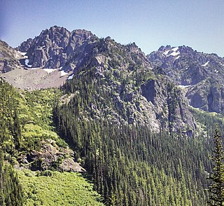
The Needles is a mountain ridge located within Olympic National Park in Jefferson County of Washington state.

Iron Mountain is a 6,826-foot (2,081-metre) elevation summit located in the eastern Olympic Mountains in Jefferson County of Washington state. It is set within Buckhorn Wilderness, on land managed by Olympic National Forest. It is situated between Buckhorn Mountain, 0.58 mi (0.93 km) to the southwest, and Mount Worthington, 0.76 mi (1.22 km) to the northeast. Precipitation runoff from Iron Mountain drains south into the Big Quilcene River, and north into Copper Creek which is a tributary of the Dungeness River. Topographic relief is significant as the southeast aspect rises 2,800 feet above the Big Quilcene River in less than one mile, and the north aspect rises 1,700 feet above Buckhorn Lake in one-half mile. Old-growth forests of Douglas fir, western hemlock, and western redcedar grow in the valleys surrounding the peak. The nearest community is Quilcene 11 miles to the east.