Bel Aire, Kansas

Last updated

Bel Aire, Kansas
Sedgwick County Kansas Incorporated and Unincorporated areas Bel Aire Highlighted.svg
Location within Sedgwick County and Kansas
Map of Sedgwick Co, Ks, USA.png
Coordinates: 37°45′50″N97°15′58″W / 37.76389°N 97.26611°W / 37.76389; -97.26611 [1]
Country United States
State Kansas
County Sedgwick
Founded1955
Incorporated 1980
Area
[2]
  Total6.79 sq mi (17.60 km2)
  Land6.76 sq mi (17.52 km2)
  Water0.03 sq mi (0.08 km2)
Elevation
[1]
1,394 ft (425 m)
Population
 (2020) [3] [4]
  Total8,262
  Density1,200/sq mi (470/km2)
Time zone UTC-6 (CST)
  Summer (DST) UTC-5 (CDT)
ZIP codes
67220, 67226
Area code 316
FIPS code 20-05400 [1]
GNIS ID 473837 [1]
Website belaireks.gov

Bel Aire is a city in Sedgwick County, Kansas, United States, [1] and a suburb of Wichita. [5] As of the 2020 census, the population of the city was 8,262. [3] [4]

Contents

History

Bel Aire was founded in January 1955 when a group of local residents petitioned the county government to create it as an improvement district for water. [6]

On November 26, 1980, Bel Aire formally incorporated as a city. This was despite a two-year legal dispute with the Wichita city government over whether or not it had the right to do so. The case ultimately went to the Kansas Supreme Court which ruled in Bel Aire's favor. [6]

Geography

Bel Aire is located at 37°45′50″N97°15′58″W / 37.76389°N 97.26611°W / 37.76389; -97.26611 (37.763758, 97.266177) at an elevation of 1,394 feet (425 m). [1] It lies on the north side of the East Fork of Chisholm Creek roughly 6 mi (9.7 km) northeast of the Arkansas River in the Wellington-McPherson Lowlands region of the Great Plains. Located on the south side of K-254 in south-central Kansas, Bel Aire is within the Wichita metropolitan area, bordered by Wichita to the south and west and bordered by Kechi to the north. [7] [8]

According to the United States Census Bureau, the city has a total area of 6.86 square miles (17.77 km2), of which, 6.83 square miles (17.69 km2) is land and 0.03 square miles (0.08 km2) is water. [9]

Demographics

Historical population
CensusPop.Note
1990 3,695
2000 5,83657.9%
2010 6,76916.0%
2020 8,26222.1%
U.S. Decennial Census
2010-2020 [4]

Bel Aire is part of the Wichita, KS Metropolitan Statistical Area.

2020 census

The 2020 United States census counted 8,262 people, 3,080 households, and 2,234 families in Bel Aire. [10] [11] The population density was 1,221.5 per square mile (471.6/km2). There were 3,258 housing units at an average density of 481.7 per square mile (186.0/km2). [11] [12] The racial makeup was 74.27% (6,136) white or European American (72.25% non-Hispanic white), 9.92% (820) black or African-American, 0.5% (41) Native American or Alaska Native, 4.56% (377) Asian, 0.04% (3) Pacific Islander or Native Hawaiian, 2.01% (166) from other races, and 8.7% (719) from two or more races. [13] Hispanic or Latino of any race was 7.6% (628) of the population. [14]

Of the 3,080 households, 32.5% had children under the age of 18; 59.3% were married couples living together; 22.6% had a female householder with no spouse or partner present. 22.6% of households consisted of individuals and 11.9% had someone living alone who was 65 years of age or older. [11] The average household size was 3.0 and the average family size was 3.3. [15] The percent of those with a bachelor’s degree or higher was estimated to be 36.4% of the population. [16]

23.7% of the population was under the age of 18, 8.3% from 18 to 24, 25.7% from 25 to 44, 23.2% from 45 to 64, and 19.1% who were 65 years of age or older. The median age was 38.3 years. For every 100 females, there were 109.0 males. [11] For every 100 females ages 18 and older, there were 110.9 males. [11]

The 2016-2020 5-year American Community Survey estimates show that the median household income was $84,605 (with a margin of error of +/- $20,847) and the median family income was $98,750 (+/- $21,163). [17] Males had a median income of $44,161 (+/- $5,434) versus $33,880 (+/- $3,945) for females. The median income for those above 16 years old was $38,015 (+/- $7,931). [18] Approximately, 4.8% of families and 7.2% of the population were below the poverty line, including 12.6% of those under the age of 18 and 1.0% of those ages 65 or over. [19] [20]

2010 census

As of the census [21] of 2010, there were 6,769 people, 2,465 households, and 1,854 families living in the city. [22] The population density was 991.1 inhabitants per square mile (382.7/km2). There were 2,554 housing units at an average density of 373.9 per square mile (144.4/km2). The racial makeup of the city was 81.1% White, 8.6% African American, 0.9% Native American, 4.5% Asian, 1.4% from other races, and 3.5% from two or more races. Hispanic or Latino of any race were 4.8% of the population.

There were 2,465 households, of which 38.7% had children under the age of 18 living with them, 65.3% were married couples living together, 7.2% had a female householder with no husband present, 2.7% had a male householder with no wife present, and 24.8% were non-families. 21.3% of all households were made up of individuals, and 9.6% had someone living alone who was 65 years of age or older. The average household size was 2.75 and the average family size was 3.21.

The median age in the city was 36 years. 28.3% of residents were under the age of 18; 6.7% were between the ages of 18 and 24; 26.3% were from 25 to 44; 26.9% were from 45 to 64; and 11.6% were 65 years of age or older. The gender makeup of the city was 48.2% male and 51.8% female.

2000 census

As of the census of 2000, there were 5,836 people, 1,976 households, and 1,618 families living in the city. The population density was 2,680.8 inhabitants per square mile (1,035.1/km2). There were 2,024 housing units at an average density of 929.7 per square mile (359.0/km2). The racial makeup of the city was 85.47% White, 7.32% African American, 0.45% Native American, 3.68% Asian, 0.02% Pacific Islander, 1.10% from other races, and 1.97% from two or more races. Hispanic or Latino of any race were 3.02% of the population.

There were 1,976 households, out of which 47.3% had children under the age of 18 living with them, 73.4% were married couples living together, 6.8% had a female householder with no husband present, and 18.1% were non-families. 15.4% of all households were made up of individuals, and 5.6% had someone living alone who was 65 years of age or older. The average household size was 2.95 and the average family size was 3.30.

In the city, the population was spread out, with 32.9% under the age of 18, 5.2% from 18 to 24, 33.2% from 25 to 44, 21.1% from 45 to 64, and 7.6% who were 65 years of age or older. The median age was 33 years. For every 100 females, there were 98.0 males. For every 100 females age 18 and over, there were 95.1 males.

As of 2000 the median income for a household in the city was $66,937, and the median income for a family was $72,091. Males had a median income of $50,236 versus $35,298 for females. The per capita income for the city was $23,202. About 3.7% of families and 4.8% of the population were below the poverty line, including 8.9% of those under age 18 and 3.0% of those age 65 or over. [23]

Education

The city is served by Wichita USD 259 and Circle USD 375 public school districts. [24] Bel Aire has two private schools as well: Sunrise Christian Academy (Pre-K to 12) and Resurrection Catholic School (Pre-K to 5). [25] [26]

The Northeast Magnet High School, operated by Wichita USD 259 public school district, is located in Bel Aire.

Related Research Articles

<span class="mw-page-title-main">Benton, Kansas</span> City in Butler County, Kansas

Benton is a city in Butler County, Kansas, United States. As of the 2020 census, the population of the city was 943. It is located northeast of Wichita along K-254 highway.

<span class="mw-page-title-main">Eureka, Kansas</span> City in Greenwood County, Kansas

Eureka is a city in and the county seat of Greenwood County, Kansas, United States. As of the 2020 census, the population of the city was 2,332.

<span class="mw-page-title-main">Kingman, Kansas</span> City in Kingman County, Kansas

Kingman is a city in and the county seat of Kingman County, Kansas, United States. As of the 2020 census, the population of the city was 3,105.

<span class="mw-page-title-main">Lehigh, Kansas</span> City in Marion County, Kansas

Lehigh is a city in Marion County, Kansas, United States. As of the 2020 census, the population of the city was 161. It is located between Hillsboro and Canton on the north side of U.S. Route 56.

<span class="mw-page-title-main">Cherryvale, Kansas</span> City in Montgomery County, Kansas

Cherryvale is a city in Montgomery County, Kansas, United States. As of the 2020 census, the population of the city was 2,192.

<span class="mw-page-title-main">Ransom, Kansas</span> City in Ness County, Kansas, United States

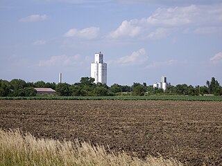
Ransom is a city in Ness County, Kansas, United States. As of the 2020 census, the population of the city was 260.

<span class="mw-page-title-main">Alton, Kansas</span> City in Osborne County, Kansas

Alton is a city in Osborne County, Kansas, United States. As of the 2020 census, the population of the city was 100.

<span class="mw-page-title-main">Larned, Kansas</span> City in Pawnee County, Kansas

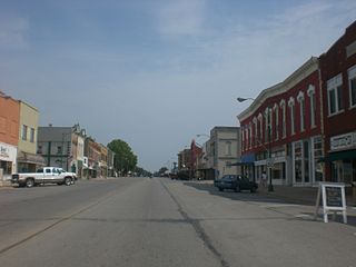
Larned is a city in and the county seat of Pawnee County, Kansas, United States. As of the 2020 census, the population of the city was 3,769.

<span class="mw-page-title-main">Pratt, Kansas</span> City in Pratt County, Kansas

Pratt is a city in and the county seat of Pratt County, Kansas, United States. As of the 2020 census, the population of the city was 6,603. It is home to Pratt Community College.

<span class="mw-page-title-main">Andale, Kansas</span> City in Sedgwick County, Kansas

Andale is a city in Sedgwick County, Kansas, United States. As of the 2020 census, the population of the city was 941.

<span class="mw-page-title-main">Bentley, Kansas</span> City in Sedgwick County, Kansas

Bentley is a city in Sedgwick County, Kansas, United States. As of the 2020 census, the population of the city was 560. It is located northwest of Wichita, approximately 4 miles north of K-96 highway at the intersection of 151st W & 109th N.

<span class="mw-page-title-main">Cheney, Kansas</span> City in Sedgwick County, Kansas

Cheney is a city in Sedgwick County, Kansas, United States. As of the 2020 census, the population of the city was 2,181.

<span class="mw-page-title-main">Colwich, Kansas</span> City in Sedgwick County, Kansas

Colwich is a city in Sedgwick County, Kansas, United States, located northwest of Wichita. As of the 2020 census, the population of the city was 1,455.

<span class="mw-page-title-main">Eastborough, Kansas</span> City in Sedgwick County, Kansas

Eastborough is a city in Sedgwick County, Kansas, United States, and an enclave of the city of Wichita. As of the 2020 census, the population of the city was 756.

<span class="mw-page-title-main">Garden Plain, Kansas</span> City in Sedgwick County, Kansas

Garden Plain is a city in Sedgwick County, Kansas, United States. As of the 2020 census, the population of the city was 948.

<span class="mw-page-title-main">Haysville, Kansas</span> City in Sedgwick County, Kansas

Haysville is a city in Sedgwick County, Kansas, United States, and a suburb of Wichita. As of the 2020 census, the population of the city was 11,262. Haysville is known as the "Peach Capital of Kansas".

<span class="mw-page-title-main">Kechi, Kansas</span> City in Sedgwick County, Kansas

Kechi is a city in Sedgwick County, Kansas, United States, and a suburb of Wichita. As of the 2020 census, the population of the city was 2,217.

<span class="mw-page-title-main">Park City, Kansas</span> City in Sedgwick County, Kansas

Park City is a city in Sedgwick County, Kansas, United States and a suburb of Wichita. As of the 2020 census, the population of the city was 8,333.

<span class="mw-page-title-main">Leoti, Kansas</span> City in Wichita County, Kansas

Leoti is a city in and the county seat of Wichita County, Kansas, United States. As of the 2020 census, the population of the city was 1,475.

<span class="mw-page-title-main">Mulvane, Kansas</span> City in Sedgwick and Sumner County, Kansas

Mulvane is a city in Sedgwick and Sumner counties in the U.S. state of Kansas. As of the 2020 census, the population of the city was 6,286.

References

  1. 1 2 3 4 5 6 "Bel Aire, Kansas", Geographic Names Information System , United States Geological Survey, United States Department of the Interior
  2. "2019 U.S. Gazetteer Files". United States Census Bureau. Retrieved July 24, 2020.
  3. 1 2 "Profile of Bel Aire, Kansas in 2020". United States Census Bureau. Archived from the original on November 14, 2021. Retrieved November 14, 2021.
  4. 1 2 3 "QuickFacts; Bel Aire, Kansas; Population, Census, 2020 & 2010". United States Census Bureau. Archived from the original on August 27, 2021. Retrieved August 27, 2021.
  5. "City of Bel Aire - Our Community". City of Bel Aire. Archived from the original on October 6, 2010. Retrieved January 22, 2011.
  6. 1 2 "City of Bel Aire - Celebrating 30 Years". City of Bel Aire. Archived from the original on October 15, 2010. Retrieved March 6, 2013.
  7. "General Highway Map - Sedgwick County, Kansas" (PDF). Kansas Department of Transportation. June 2009. Archived (PDF) from the original on December 17, 2010. Retrieved January 22, 2011.
  8. "2003-2004 Official Transportation Map" (PDF). Kansas Department of Transportation. 2003. Retrieved January 22, 2011.
  9. "US Gazetteer files 2010". United States Census Bureau. Archived from the original on January 25, 2012. Retrieved July 6, 2012.
  10. "US Census Bureau, Table P16: HOUSEHOLD TYPE". data.census.gov. Retrieved January 2, 2024.
  11. 1 2 3 4 5 "US Census Bureau, Table DP1: PROFILE OF GENERAL POPULATION AND HOUSING CHARACTERISTICS". data.census.gov. Retrieved January 2, 2024.
  12. "Gazetteer Files". Census.gov. Retrieved December 30, 2023.
  13. "US Census Bureau, Table P1: RACE". data.census.gov. Retrieved January 2, 2024.
  14. "US Census Bureau, Table P2: HISPANIC OR LATINO, AND NOT HISPANIC OR LATINO BY RACE". data.census.gov. Retrieved January 2, 2024.
  15. "US Census Bureau, Table S1101: HOUSEHOLDS AND FAMILIES". data.census.gov. Retrieved January 2, 2024.
  16. "US Census Bureau, Table S1501: EDUCATIONAL ATTAINMENT". data.census.gov. Retrieved January 2, 2024.
  17. "US Census Bureau, Table S1903: MEDIAN INCOME IN THE PAST 12 MONTHS (IN 2020 INFLATION-ADJUSTED DOLLARS)". data.census.gov. Retrieved January 2, 2024.
  18. "US Census Bureau, Table S2001: EARNINGS IN THE PAST 12 MONTHS (IN 2020 INFLATION-ADJUSTED DOLLARS)". data.census.gov. Retrieved January 2, 2024.
  19. "US Census Bureau, Table S1701: POVERTY STATUS IN THE PAST 12 MONTHS". data.census.gov. Retrieved January 2, 2024.
  20. "US Census Bureau, Table S1702: POVERTY STATUS IN THE PAST 12 MONTHS OF FAMILIES". data.census.gov. Retrieved January 2, 2024.
  21. "U.S. Census website". United States Census Bureau . Retrieved July 6, 2012.
  22. "2010 City Population and Housing Occupancy Status". U.S. Census Bureau. Retrieved March 6, 2011.[ dead link ]
  23. "U.S. Census website". United States Census Bureau . Retrieved January 31, 2008.
  24. "Public Schools | Bel Aire, KS". www.belaireks.gov. Retrieved December 23, 2020.
  25. "Private Schools in Bel Aire, KS". Niche. Retrieved December 23, 2020.
  26. "Private Schools | Bel Aire, KS". www.belaireks.gov. Retrieved December 23, 2020.

Further reading