Garden Plain, Kansas

Last updated

Garden Plain, Kansas
Sedgwick County Kansas Incorporated and Unincorporated areas Garden Plain Highlighted.svg
Location within Sedgwick County and Kansas
Map of Sedgwick Co, Ks, USA.png
Coordinates: 37°39′38″N97°40′55″W / 37.66056°N 97.68194°W / 37.66056; -97.68194 [1]
Country United States
State Kansas
County Sedgwick
Founded1884
Incorporated 1902
Area
[2]
  Total1.02 sq mi (2.63 km2)
  Land1.02 sq mi (2.63 km2)
  Water0.00 sq mi (0.00 km2)
Elevation
[1]
1,450 ft (440 m)
Population
 (2020) [3]
  Total948
  Density930/sq mi (360/km2)
Time zone UTC-6 (CST)
  Summer (DST) UTC-5 (CDT)
ZIP code
67050
Area code 316
FIPS code 20-25375 [1]
GNIS ID 473990 [1]
Website gardenplain.com

Garden Plain is a city in Sedgwick County, Kansas, United States. [1] As of the 2020 census, the population of the city was 948. [3]

Contents

History

Garden Plain had its start by the building of the Wichita and Western Railroad from Wichita to Kingman. [4] Garden Plain was incorporated in 1902. [5]

Geography

Garden Plain is located at 37°39′38″N97°40′55″W / 37.66056°N 97.68194°W / 37.66056; -97.68194 (37.660451, -97.681811). [6] According to the United States Census Bureau, the city has a total area of 0.60 square miles (1.55 km2), all of it land. [7]

Demographics

Historical population
CensusPop.Note
1910 296
1920 36122.0%
1930 336−6.9%
1940 323−3.9%
1950 3230.0%
1960 56073.4%
1970 67821.1%
1980 77514.3%
1990 731−5.7%
2000 7979.0%
2010 8496.5%
2020 94811.7%
U.S. Decennial Census

2020 census

The 2020 United States census counted 948 people, 336 households, and 240 families in Garden Plain. [8] [9] The population density was 908.0 per square mile (350.6/km2). There were 349 housing units at an average density of 334.3 per square mile (129.1/km2). [9] [10] The racial makeup was 92.51% (877) white or European American (91.03% non-Hispanic white), 0.11% (1) black or African-American, 0.11% (1) Native American or Alaska Native, 0.42% (4) Asian, 0.0% (0) Pacific Islander or Native Hawaiian, 1.16% (11) from other races, and 5.7% (54) from two or more races. [11] Hispanic or Latino of any race was 3.38% (32) of the population. [12]

Of the 336 households, 38.7% had children under the age of 18; 60.4% were married couples living together; 22.6% had a female householder with no spouse or partner present. 25.6% of households consisted of individuals and 15.2% had someone living alone who was 65 years of age or older. [9] The average household size was 3.2 and the average family size was 3.8. [13] The percent of those with a bachelor’s degree or higher was estimated to be 24.1% of the population. [14]

27.8% of the population was under the age of 18, 7.4% from 18 to 24, 23.8% from 25 to 44, 25.3% from 45 to 64, and 15.6% who were 65 years of age or older. The median age was 37.0 years. For every 100 females, there were 110.2 males. [9] For every 100 females ages 18 and older, there were 113.1 males. [9]

The 2016-2020 5-year American Community Survey estimates show that the median household income was $80,833 (with a margin of error of +/- $21,824) and the median family income was $95,208 (+/- $28,540). [15] Males had a median income of $51,563 (+/- $24,700) versus $17,399 (+/- $11,604) for females. The median income for those above 16 years old was $33,125 (+/- $10,530). [16] Approximately, 20.4% of families and 19.8% of the population were below the poverty line, including 28.6% of those under the age of 18 and 7.7% of those ages 65 or over. [17] [18]

2010 census

As of the census [19] of 2010, there were 849 people, 308 households, and 221 families residing in the city. The population density was 1,415.0 inhabitants per square mile (546.3/km2). There were 320 housing units at an average density of 533.3 per square mile (205.9/km2). The racial makeup of the city was 97.8% White, 0.4% African American, 0.2% Native American, 0.1% Asian, 0.2% from other races, and 1.3% from two or more races. Hispanic or Latino of any race were 0.6% of the population.

There were 308 households, of which 43.2% had children under the age of 18 living with them, 58.4% were married couples living together, 8.8% had a female householder with no husband present, 4.5% had a male householder with no wife present, and 28.2% were non-families. 26.9% of all households were made up of individuals, and 15.3% had someone living alone who was 65 years of age or older. The average household size was 2.76 and the average family size was 3.40.

The median age in the city was 34.5 years. 33.1% of residents were under the age of 18; 6.8% were between the ages of 18 and 24; 24.9% were from 25 to 44; 22.5% were from 45 to 64; and 12.7% were 65 years of age or older. The gender makeup of the city was 49.7% male and 50.3% female.

2000 census

As of the census [20] of 2000, there were 797 people, 286 households, and 201 families residing in the city. The population density was 1,474.8 inhabitants per square mile (569.4/km2). There were 292 housing units at an average density of 540.3 per square mile (208.6/km2). The racial makeup of the city was 97.37% White, 0.38% African American, 0.63% Native American, 0.13% Asian, 0.63% from other races, and 0.88% from two or more races. Hispanic or Latino of any race were 1.38% of the population.

There were 286 households, out of which 39.9% had children under the age of 18 living with them, 60.8% were married couples living together, 7.7% had a female householder with no husband present, and 29.4% were non-families. 27.3% of all households were made up of individuals, and 15.4% had someone living alone who was 65 years of age or older. The average household size was 2.79 and the average family size was 3.47.

In the city, the population was spread out, with 34.5% under the age of 18, 5.5% from 18 to 24, 26.9% from 25 to 44, 19.1% from 45 to 64, and 14.1% who were 65 years of age or older. The median age was 34 years. For every 100 females, there were 102.8 males. For every 100 females age 18 and over, there were 97.7 males.

As of 2000 the median income for a household in the city was $48,068, and the median income for a family was $56,375. Males had a median income of $40,750 versus $25,577 for females. The per capita income for the city was $22,946. About 2.8% of families and 4.0% of the population were below the poverty line, including 3.0% of those under age 18 and 6.7% of those age 65 or over.

Education

The community is served by Renwick USD 267 public school district. [21]

The Garden Plain Owls have won the following Kansas State High School championships:

Transportation

U.S. Routes 54 / 400 is located a few blocks north of the city running east–west. Many streets in the area are of dirt gravel.

The K&O Railroad line connects to the city from the west. The line east of the city is abandoned.

Notable people

Notable individuals who were born in and/or have lived in Garden Plain include:

See also

Related Research Articles

<span class="mw-page-title-main">Claflin, Kansas</span> City in Barton County, Kansas

Claflin is a city in Barton County, Kansas, United States. As of the 2020 census, the population of the city was 562.

<span class="mw-page-title-main">Burlington, Kansas</span> City in Coffey County, Kansas, United States

Burlington is a city in and the county seat of Coffey County, Kansas, United States. As of the 2020 census, the population of the city was 2,634.

<span class="mw-page-title-main">Burden, Kansas</span> City in Cowley County, Kansas

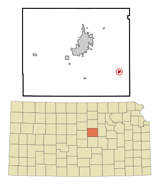
Burden is a city in Cowley County, Kansas, United States. As of the 2020 census, the population of the city was 512.

<span class="mw-page-title-main">Grainfield, Kansas</span> City in Gove County, Kansas, United States

Grainfield is a city in northern Gove County, Kansas, United States. As of the 2020 census, the population of the city was 322.

<span class="mw-page-title-main">Grinnell, Kansas</span> City in Gove County, Kansas

Grinnell is a city in Gove County, Kansas, United States. As of the 2020 census, the population of the city was 260.

<span class="mw-page-title-main">Ensign, Kansas</span> City in Gray County, Kansas

Ensign is a city in Gray County, Kansas, United States. As of the 2020 census, the population of the city was 166. It is located along U.S. Route 56 highway.

<span class="mw-page-title-main">Burrton, Kansas</span> City in Harvey County, Kansas

Burrton is a city in Harvey County, Kansas, United States. It is named after Isaac T. Burr, former vice-president of the Atchison, Topeka and Santa Fe Railway. As of the 2020 census, the population of the city was 861.

<span class="mw-page-title-main">Hanston, Kansas</span> City in Hodgeman County, Kansas

Hanston is a city in Hodgeman County, Kansas, United States. As of the 2020 census, the population of the city was 259.

<span class="mw-page-title-main">Frankfort, Kansas</span> City in Marshall County, Kansas

Frankfort is a city in Marshall County, Kansas, United States. As of the 2020 census, the population of the city was 730.

<span class="mw-page-title-main">Dwight, Kansas</span> City in Morris County, Kansas

Dwight is a city in Morris County, Kansas, United States. As of the 2020 census, the population of the city was 217.

<span class="mw-page-title-main">Bazine, Kansas</span> City in Ness County, Kansas

Bazine is a city in Ness County, Kansas, United States. As of the 2020 census, the population of the city was 282.

<span class="mw-page-title-main">Downs, Kansas</span> City in Osborne County, Kansas

Downs is a city in Osborne County, Kansas, United States. As of the 2020 census, the population of the city was 800.

<span class="mw-page-title-main">Burdett, Kansas</span> City in Pawnee County, Kansas

Burdett is a city in Pawnee County, Kansas, United States. As of the 2020 census, the population of the city was 228.

<span class="mw-page-title-main">Bushton, Kansas</span> City in Rice County, Kansas

Bushton is a city in Rice County, Kansas, United States. As of the 2020 census, the population of the city was 203.

<span class="mw-page-title-main">Dorrance, Kansas</span> City in Russell County, Kansas

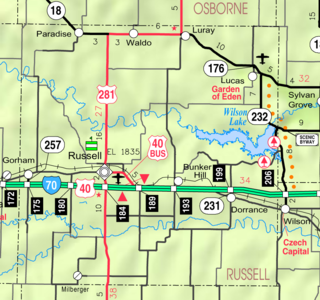
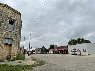
Dorrance is a city in Russell County, Kansas, United States. As of the 2020 census, the population of the city was 146.

<span class="mw-page-title-main">Gypsum, Kansas</span> City in Saline County, Kansas

Gypsum is a city in Saline County, Kansas, United States. As of the 2020 census, the population of the city was 400.

<span class="mw-page-title-main">Bel Aire, Kansas</span> City in Sedgwick County, Kansas

Bel Aire is a city in Sedgwick County, Kansas, United States, and a suburb of Wichita. As of the 2020 census, the population of the city was 8,262.

<span class="mw-page-title-main">Cheney, Kansas</span> City in Sedgwick County, Kansas

Cheney is a city in Sedgwick County, Kansas, United States. As of the 2020 census, the population of the city was 2,181.

<span class="mw-page-title-main">Lebanon, Kansas</span> City in Smith County, Kansas

Lebanon is a city in Smith County, Kansas, United States. As of the 2020 census, the population of the city was 178.

<span class="mw-page-title-main">Brewster, Kansas</span> City in Thomas County, Kansas

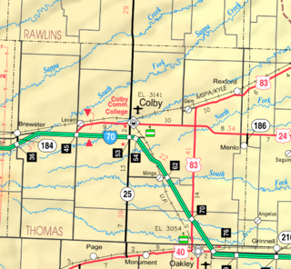
Brewster is a city in Thomas County, Kansas, United States. As of the 2020 census, the population of the city was 291.

References

  1. 1 2 3 4 5 "Garden Plain, Kansas", Geographic Names Information System , United States Geological Survey, United States Department of the Interior
  2. "2019 U.S. Gazetteer Files". United States Census Bureau. Retrieved July 24, 2020.
  3. 1 2 "Profile of Garden Plain, Kansas in 2020". United States Census Bureau. Archived from the original on November 14, 2021. Retrieved November 14, 2021.
  4. Bentley, Orsemus Hills (1910). History of Wichita and Sedgwick County, Kansas: Past and Present. Windmill Publications. p. 629.
  5. Blackmar, Frank Wilson (1912). Kansas: A Cyclopedia of State History, Embracing Events, Institutions, Industries, Counties, Cities, Towns, Prominent Persons, Etc. Standard Publishing Company. pp.  709.
  6. "US Gazetteer files: 2010, 2000, and 1990". United States Census Bureau. February 12, 2011. Retrieved April 23, 2011.
  7. "US Gazetteer files 2010". United States Census Bureau. Archived from the original on July 2, 2012. Retrieved July 6, 2012.
  8. "US Census Bureau, Table P16: HOUSEHOLD TYPE". data.census.gov. Retrieved January 3, 2024.
  9. 1 2 3 4 5 "US Census Bureau, Table DP1: PROFILE OF GENERAL POPULATION AND HOUSING CHARACTERISTICS". data.census.gov. Retrieved January 3, 2024.
  10. Bureau, US Census. "Gazetteer Files". Census.gov. Retrieved December 30, 2023.
  11. "US Census Bureau, Table P1: RACE". data.census.gov. Retrieved January 3, 2024.
  12. "US Census Bureau, Table P2: HISPANIC OR LATINO, AND NOT HISPANIC OR LATINO BY RACE". data.census.gov. Retrieved January 3, 2024.
  13. "US Census Bureau, Table S1101: HOUSEHOLDS AND FAMILIES". data.census.gov. Retrieved January 3, 2024.
  14. "US Census Bureau, Table S1501: EDUCATIONAL ATTAINMENT". data.census.gov. Retrieved January 3, 2024.
  15. "US Census Bureau, Table S1903: MEDIAN INCOME IN THE PAST 12 MONTHS (IN 2020 INFLATION-ADJUSTED DOLLARS)". data.census.gov. Retrieved January 3, 2024.
  16. "US Census Bureau, Table S2001: EARNINGS IN THE PAST 12 MONTHS (IN 2020 INFLATION-ADJUSTED DOLLARS)". data.census.gov. Retrieved January 3, 2024.
  17. "US Census Bureau, Table S1701: POVERTY STATUS IN THE PAST 12 MONTHS". data.census.gov. Retrieved January 3, 2024.
  18. "US Census Bureau, Table S1702: POVERTY STATUS IN THE PAST 12 MONTHS OF FAMILIES". data.census.gov. Retrieved January 3, 2024.
  19. "U.S. Census website". United States Census Bureau . Retrieved July 6, 2012.
  20. "U.S. Census website". United States Census Bureau . Retrieved January 31, 2008.
  21. "Renwick USD 267". USD 267. Retrieved January 6, 2017.
  22. 1 2 3 4 5 6 7 "Basketball". KSHSAA. Retrieved January 3, 2017.
  23. "Football". KSHSAA. Archived from the original on December 20, 2016. Retrieved January 3, 2017.
  24. Fretz, W. David (June 10, 2009). ""Jarrin Jim" Bausch; Kansas University's First All American and Ignored by Kansas Football Historians". The Topeka Capital-Journal. Retrieved April 7, 2016.
  25. "Dan Kerschen's Biography". Vote Smart. Retrieved April 7, 2016.

Further reading