Bethel, Missouri

Last updated

Bethel, Missouri
Shelby County Missouri Incorporated and Unincorporated areas Bethel Highlighted.svg
Location of Bethel, Missouri
Coordinates: 39°52′38″N92°1′28″W / 39.87722°N 92.02444°W / 39.87722; -92.02444
Country United States
State Missouri
County Shelby
Area
[1]
  Total0.14 sq mi (0.36 km2)
  Land0.14 sq mi (0.36 km2)
  Water0.00 sq mi (0.00 km2)
Elevation
715 ft (218 m)
Population
 (2020)
  Total135
  Density978.26/sq mi (377.82/km2)
Time zone UTC-6 (Central (CST))
  Summer (DST) UTC-5 (CDT)
ZIP code
63434
Area code 660
FIPS code 29-05104 [2]
GNIS feature ID0714027 [3]

Bethel is a village in Shelby County, Missouri, United States. The population was 135 at the 2020 census. [4]

Contents

History

Bethel was founded as a Bible utopian colony in 1844 by Dr William Keil (1811–1877), a Prussian-born preacher. [5] He and his followers, who were almost exclusively German immigrants to America, believed that the Book of Acts required that Christians hold all property and means of production in common and they organized their Colony accordingly. Traditionally male work was communally performed; however, traditionally female work was still individualized and performed in single family households.

By 1850, the Bethel Colony had a population of 500; by 1860, 600. It owned thousands of sheep, cattle and horses, and had over 3,500 acres under cultivation. It was the commercial center of the region. However, the construction of the Hannibal & St. Joseph Railroad threatened Dr. Keil's theocracy. In 1855, he led his some of his followers westward over the Oregon Trail, to eventually settle Aurora, Oregon and form the Aurora Colony. [6] Other wagon trains followed in subsequent years. The remainder of the Bethel Colony retained their communal ownership of property and shared means of production until three years after his death in 1877. In 1880, the property was divided among the remaining members, thus ending Missouri's most successful communal experiment.

The Bethel Historic District, bounded by Liberty, King, 1st, and 4th Streets, was listed on the National Register of Historic Places in 1970. [7] At least twenty of the buildings constructed by the Bethel Colony are still extant. These houses are on exhibit to visitors and to the public.

Also listed on the National Register of Historic Places are nearby Elim and Hebron. [7]

Geography

Bethel is located at 39°52′38″N92°1′28″W / 39.87722°N 92.02444°W / 39.87722; -92.02444 (39.877205, -92.024433). [8]

According to the United States Census Bureau, the village has a total area of 0.14 square miles (0.36 km2), all land. [9]

Demographics

Historical population
CensusPop.Note
1880 184
1900 225
1910 2354.4%
1920 2548.1%
1930 251−1.2%
1940 217−13.5%
1950 194−10.6%
1960 152−21.6%
1970 143−5.9%
1980 132−7.7%
1990 117−11.4%
2000 1213.4%
2010 1220.8%
2020 13510.7%
U.S. Decennial Census [10]

2010 census

As of the census [11] of 2010, there were 122 people, 60 households, and 34 families living in the village. The population density was 871.4 inhabitants per square mile (336.4/km2). There were 79 housing units at an average density of 564.3 per square mile (217.9/km2). The racial makeup of the village was 93.4% White, 2.5% from other races, and 4.1% from two or more races. Hispanic or Latino of any race were 2.5% of the population.

There were 60 households, of which 25.0% had children under the age of 18 living with them, 43.3% were married couples living together, 8.3% had a female householder with no husband present, 5.0% had a male householder with no wife present, and 43.3% were non-families. 41.7% of all households were made up of individuals, and 20% had someone living alone who was 65 years of age or older. The average household size was 2.03 and the average family size was 2.74.

The median age in the village was 45.7 years. 21.3% of residents were under the age of 18; 5% were between the ages of 18 and 24; 22.2% were from 25 to 44; 27% were from 45 to 64; and 24.6% were 65 years of age or older. The gender makeup of the village was 53.3% male and 46.7% female.

2000 census

As of the census [2] of 2000, there were 121 people, 56 households, and 31 families living in the village. The population density was 856.5 inhabitants per square mile (330.7/km2). There were 77 housing units at an average density of 545.0 per square mile (210.4/km2). The racial makeup of the village was 98.35% White, and 1.65% from two or more races.

There were 56 households, out of which 26.8% had children under the age of 18 living with them, 44.6% were married couples living together, 10.7% had a female householder with no husband present, and 44.6% were non-families. 42.9% of all households were made up of individuals, and 17.9% had someone living alone who was 65 years of age or older. The average household size was 2.16 and the average family size was 3.03.

In the village, the population was spread out, with 24.0% under the age of 18, 10.7% from 18 to 24, 24.0% from 25 to 44, 25.6% from 45 to 64, and 15.7% who were 65 years of age or older. The median age was 40 years. For every 100 females, there were 112.3 males. For every 100 females age 18 and over, there were 80.4 males.

The median income for a household in the village was $22,083, and the median income for a family was $53,750. Males had a median income of $22,292 versus $21,000 for females. The per capita income for the village was $13,958. There were no families and 6.8% of the population living below the poverty line, including no under eighteens and 42.9% of those over 64.

Notable person

Related Research Articles

<span class="mw-page-title-main">Bethel, Minnesota</span> City in Minnesota, United States

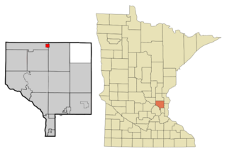
Bethel is a city in Anoka County, Minnesota, United States. The population was 466 at the 2010 census.

<span class="mw-page-title-main">East Bethel, Minnesota</span> City in Minnesota, United States

East Bethel is a city in Anoka County, Minnesota, United States. The population was 11,786 at the 2020 census.

<span class="mw-page-title-main">Waltham, Minnesota</span> City in Minnesota, United States

Waltham is a city in Waltham Township, Mower County, Minnesota, United States. The population was 151 at the 2010 census.

<span class="mw-page-title-main">Cross Timbers, Missouri</span> City in Missouri, United States

Cross Timbers is a city in Hickory County, Missouri, United States. The population was 119 at the 2020 census.

<span class="mw-page-title-main">Airport Drive, Missouri</span> Village in Missouri, United States

Airport Drive is a village in Jasper County, Missouri, United States. The population was 766 at the 2020 census. It is part of the Joplin, Missouri Metropolitan Statistical Area. The community is still commonly referred to as "Stone's Corner," as the intersection of Route 43 and Route 171 is known.

<span class="mw-page-title-main">Flemington, Missouri</span> Village in Missouri, United States

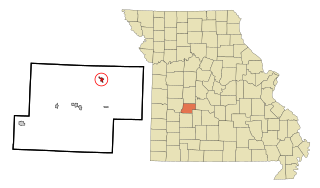
Flemington is a village in Polk County, Missouri, United States. The population was 148 at the 2010 census. It is part of the Springfield, Missouri Metropolitan Statistical Area.

<span class="mw-page-title-main">Bellerive Acres, Missouri</span> City in Missouri, United States

Bellerive Acres is a northern suburban city in St. Louis County, Missouri, United States. The population was 188 at the 2010 census. In April, 2015, the residents voted to change the village of Bellerive to a fourth class city named Bellerive Acres.

<span class="mw-page-title-main">Country Life Acres, Missouri</span> Village in Missouri, United States

Country Life Acres is a village in St. Louis County, Missouri, United States. The population was 74 at the 2010 census.

<span class="mw-page-title-main">Glen Echo Park, Missouri</span> Village in Missouri, United States

Glen Echo Park is a village in St. Louis County, Missouri, United States. The population was 160 at the 2010 census. The community took its name from the Glen Echo Country Club.

<span class="mw-page-title-main">Pasadena Park, Missouri</span> Village in Missouri, United States

Pasadena Park is a village in St. Louis County, Missouri, United States. The population was 470 at the 2010 census. It is part of the Normandy School District, and is distinct from the city of Pasadena Hills.

<span class="mw-page-title-main">Twin Oaks, Missouri</span> Village in Missouri, United States

Twin Oaks is a 4th class city in St. Louis County, Missouri, United States. The former Village of Twin Oaks changed its status to that of a city by public election in November 2016. The population was 392 at the 2010 census.

<span class="mw-page-title-main">Wilbur Park, Missouri</span> Village in Missouri, United States

Wilbur Park is a village in St. Louis County, Missouri, United States. The population was 439 at the 2020 census.

<span class="mw-page-title-main">Phillipsburg, Missouri</span> Village in Missouri, United States

Phillipsburg is a village in Laclede County, Missouri, United States. The population was 202 at the 2010 census.

<span class="mw-page-title-main">Champ, Missouri</span> Village in Missouri, United States

Champ is a village in St. Louis County, Missouri, United States. The population was 10 at the 2020 census.

<span class="mw-page-title-main">Hanley Hills, Missouri</span> Village in Missouri, United States

Hanley Hills is a village in St. Louis County, Missouri, United States. The population was 2,101 at the 2010 census.

<span class="mw-page-title-main">Uplands Park, Missouri</span> Village in Missouri, United States

Uplands Park is a village in St. Louis County, Missouri, United States. The population was 445 at the 2010 census. The village is one of many small majority black communities located in the Natural Bridge corridor of mid-St. Louis County, characterized by small homes on small lots.

<span class="mw-page-title-main">Bethel, Ohio</span> Village in Ohio, United States

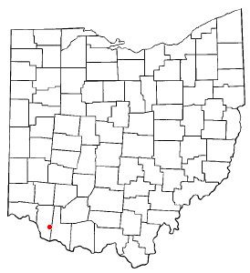
Bethel is a village in Tate Township, Clermont County, Ohio, United States. The population was 2,620 at the 2020 census. Bethel was founded in 1798 by Obed Denham as Denham Town, in what was then the Northwest Territory. Bethel is the home of the first movie theater in Ohio which was founded in 1908.

<span class="mw-page-title-main">Riverlea, Ohio</span> Village in Ohio, United States

Riverlea is a village in Franklin County, Ohio, United States, surrounded by Worthington on its north, south, and east sides, and bordered on the west by the Olentangy River, across which is Columbus. Riverlea was incorporated in 1939, a small community that formed on former farmland. The population was 599 at the 2020 census.

<span class="mw-page-title-main">Aurora, Oregon</span> City in Oregon, United States

Aurora is a city in Marion County, Oregon, United States and is home to the nation's largest not-for-profit air ambulance company, Life Flight Network. Before being incorporated as a city, it was the location of the Aurora Colony, a religious commune founded in 1856 by William Keil and John E. Schmit. William named the settlement after his daughter. The population was 1,133 at the 2020 Census. It is part of the Salem Metropolitan Statistical Area.

<span class="mw-page-title-main">Wien, Wisconsin</span> Town in Wisconsin, United States

Wien is a town in Marathon County, Wisconsin, United States. It is part of the Wausau, Wisconsin Metropolitan Statistical Area. The population was 825 at the 2010 census. The unincorporated community of Wien is located in the town.

References

  1. "ArcGIS REST Services Directory". United States Census Bureau. Retrieved August 28, 2022.
  2. 1 2 "U.S. Census website". United States Census Bureau . Retrieved January 31, 2008.
  3. "US Board on Geographic Names". United States Geological Survey. October 25, 2007. Retrieved January 31, 2008.
  4. "Explore Census Data". data.census.gov. Retrieved December 20, 2021.
  5. Earngey, Bill (1995). Missouri Roadsides: The Traveler's Companion. University of Missouri Press. p. 16. ISBN   9780826210210.
  6. Aurora, The Oregon Encyclopedia
  7. 1 2 "National Register Information System". National Register of Historic Places . National Park Service. July 9, 2010.
  8. "US Gazetteer files: 2010, 2000, and 1990". United States Census Bureau. February 12, 2011. Retrieved April 23, 2011.
  9. "US Gazetteer files 2010". United States Census Bureau. Archived from the original on July 2, 2012. Retrieved July 8, 2012.
  10. "Census of Population and Housing". Census.gov. Retrieved June 4, 2015.
  11. "U.S. Census website". United States Census Bureau . Retrieved July 8, 2012.

Nordhoff, Charles. The Communistic Societies of the United States from Personal Vision and Observation.... 1875. NY: Schocken Books, 1965.

Hinds, William. American Communities and Co-Operative Colonies. Chicago: Charles H. Kerk & Co., 1908.