Clarence, Missouri

Last updated

Clarence, Missouri
Shelby County Missouri Incorporated and Unincorporated areas Clarence Highlighted.svg
Location of Clarence, Missouri
Coordinates: 39°44′34″N92°15′40″W / 39.74278°N 92.26111°W / 39.74278; -92.26111
Country United States
State Missouri
County Shelby
Area
[1]
  Total1.16 sq mi (3.00 km2)
  Land1.16 sq mi (3.00 km2)
  Water0.00 sq mi (0.00 km2)
Elevation
[2]
820 ft (250 m)
Population
 (2020)
  Total738
  Density637.86/sq mi (246.18/km2)
Time zone UTC-6 (Central (CST))
  Summer (DST) UTC-5 (CDT)
ZIP code
63437
Area code 660
FIPS code 29-13978 [3]
GNIS feature ID0715868 [2]
Website www.cityofclarence.com

Clarence is a city in western Shelby County, Missouri, United States. The population was 738 at the 2020 census. [4]

Contents

History

Clarence was founded in 1857. [5] According to tradition, the community has the name of Clarence Duff, the son of a pioneer citizen. [6] A post office called Clarence has been in operation since 1859. [7]

Geography

Clarence is located in southwest Shelby County on Missouri Route 151 along the south side of U.S. Route 36 approximately ten miles east of Macon in adjacent Macon County. [8]

According to the United States Census Bureau, the city has a total area of 1.16 square miles (3.00 km2), all land. [9]

Demographics

Historical population
CensusPop.Note
1870 444
1880 57028.4%
1890 1,07889.1%
1900 1,1849.8%
1910 1,32211.7%
1920 1,4005.9%
1930 1,286−8.1%
1940 1,157−10.0%
1950 1,123−2.9%
1960 1,103−1.8%
1970 1,050−4.8%
1980 1,1479.2%
1990 1,026−10.5%
2000 915−10.8%
2010 813−11.1%
2020 738−9.2%
U.S. Decennial Census [10]

2010 census As of the census [11] of 2010, there were 813 people, 355 households, and 199 families living in the city. The population density was 700.9 inhabitants per square mile (270.6/km2). There were 439 housing units at an average density of 378.4 per square mile (146.1/km2). The racial makeup of the city was 98.0% White, 0.5% African American, 0.2% Native American, 0.1% from other races, and 1.1% from two or more races. Hispanic or Latino of any race were 1.4% of the population.

There were 355 households, of which 28.2% had children under the age of 18 living with them, 40.8% were married couples living together, 11.8% had a female householder with no husband present, 3.4% had a male householder with no wife present, and 43.9% were non-families. 40.6% of all households were made up of individuals, and 21.4% had someone living alone who was 65 years of age or older. The average household size was 2.17 and the average family size was 2.94.

The median age in the city was 43.3 years. 26% of residents were under the age of 18; 4.3% were between the ages of 18 and 24; 21.3% were from 25 to 44; 24.3% were from 45 to 64; and 23.9% were 65 years of age or older. The gender makeup of the city was 46.9% male and 53.1% female.

2000 census

As of the census [3] of 2000, there were 915 people, 398 households, and 228 families living in the city. The population density was 784.9 inhabitants per square mile (303.1/km2). There were 466 housing units at an average density of 399.8 per square mile (154.4/km2). The racial makeup of the city was 98.25% White, 0.44% African American, 0.33% Native American, 0.11% Asian, and 0.87% from two or more races. Hispanic or Latino of any race were 0.33% of the population.

There were 398 households, out of which 25.4% had children under the age of 18 living with them, 47.0% were married couples living together, 8.5% had a female householder with no husband present, and 42.7% were non-families. 39.2% of all households were made up of individuals, and 24.1% had someone living alone who was 65 years of age or older. The average household size was 2.20 and the average family size was 3.00.

In the city the population was spread out, with 23.1% under the age of 18, 8.2% from 18 to 24, 22.2% from 25 to 44, 23.3% from 45 to 64, and 23.3% who were 65 years of age or older. The median age was 42 years. For every 100 females there were 81.2 males. For every 100 females age 18 and over, there were 77.8 males.

The median income for a household in the city was $21,513, and the median income for a family was $31,397. Males had a median income of $20,469 versus $16,518 for females. The per capita income for the city was $12,970. About 16.1% of families and 19.0% of the population were below the poverty line, including 26.0% of those under age 18 and 17.2% of those age 65 or over.

Education

Clarence is served by Shelby County R-IV School District. The city has a lending library, the Clarence Public Library. [12]

Notable People

Related Research Articles

<span class="mw-page-title-main">Shelby County, Missouri</span> County in Missouri, United States

Shelby County is a county located in the northeastern portion of the U.S. state of Missouri. As of the 2020 census, the population was 6,103. Its county seat is Shelbyville. The county was established on January 2, 1835, and named for Governor Isaac Shelby of Kentucky.

<span class="mw-page-title-main">Calera, Alabama</span> City in Alabama, United States

Calera is a city in Shelby and Chilton counties in the U.S. state of Alabama. It is the location of the Shelby County Airport.

<span class="mw-page-title-main">Utica, Michigan</span> City in Michigan, United States

Utica is a city in Macomb County in the U.S. state of Michigan. The population was 4,757 at the 2010 census.

<span class="mw-page-title-main">Amoret, Missouri</span> City in Missouri, United States

Amoret is a city in western Bates County, Missouri, and is part of the Kansas City metropolitan area within the United States. The population was 133 at the 2020 census.

<span class="mw-page-title-main">Gunn City, Missouri</span> Village in Missouri, United States

Gunn City is a village in Cass County, Missouri, United States. The population was 118 at the 2010 census. It is part of the Kansas City metropolitan area.

<span class="mw-page-title-main">Waverly, Missouri</span> City in Missouri, United States

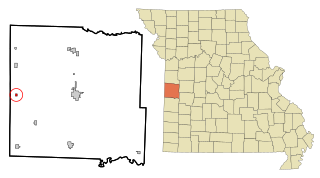
Waverly is a city in Lafayette County, Missouri, and part of the Kansas City metropolitan area within the United States. The population was 849 at the 2010 census.

<span class="mw-page-title-main">Meadville, Missouri</span> City in Missouri, United States

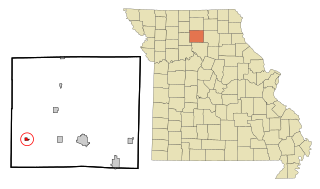
Meadville is a city in southwest Linn County, Missouri, United States. The population was 415 at the 2020 census.

<span class="mw-page-title-main">Madison, Missouri</span> City in Missouri, United States

Madison is a city in Monroe County, Missouri, United States. The population was 515 at the 2020 census.

<span class="mw-page-title-main">Morehouse, Missouri</span> City in Missouri, United States

Morehouse is a city in New Madrid County, Missouri, United States. The population was 973 at the 2010 census.

<span class="mw-page-title-main">Center, Missouri</span> City in Missouri, United States

Center is a city in Ralls County, Missouri, United States. The population was 528 at the 2020 census. It is part of the Hannibal Micropolitan Statistical Area.

<span class="mw-page-title-main">Hunnewell, Missouri</span> City in Missouri, United States

Hunnewell is a city in southeastern Shelby County, Missouri, United States. The population was 139 at the 2020 census.

<span class="mw-page-title-main">Leonard, Missouri</span> Village in Missouri, United States

Leonard is a village in northwestern Shelby County, Missouri, United States. The population was 57 at the 2020 census.

<span class="mw-page-title-main">Shelbina, Missouri</span> City in Missouri, United States

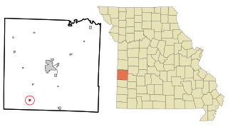
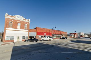
Shelbina is a city in southern Shelby County, Missouri, United States. The population was 1,613 at the 2020 census.

<span class="mw-page-title-main">Shelbyville, Missouri</span> City in Missouri, United States

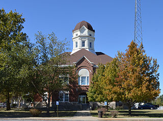
Shelbyville is a city in Shelby County, Missouri, United States. The population was 518 at the 2020 census. It is the county seat of Shelby County.

<span class="mw-page-title-main">Leadington, Missouri</span> City in Missouri, United States

Leadington is a city in St. Francois County, Missouri, United States. The population was 422 at the 2010 census.

<span class="mw-page-title-main">Beverly Hills, Missouri</span> City in Missouri, United States

Beverly Hills is a city in St. Louis County, Missouri, United States. As of the 2010 census, the city population was 574.

<span class="mw-page-title-main">Winchester, Missouri</span> City in Missouri, United States

Winchester is a city in St. Louis County, Missouri, United States. The population was 1,447 at the 2020 census.

<span class="mw-page-title-main">Woodson Terrace, Missouri</span> City in Missouri, United States

Woodson Terrace is a city in St. Louis County, Missouri, United States. The population was 4,063 at the 2010 census.

<span class="mw-page-title-main">Bronaugh, Missouri</span> City in Missouri, United States

Bronaugh is a city in southwest Vernon County, Missouri, United States. The population was 249 at the 2010 census.

<span class="mw-page-title-main">Shelby, Iowa</span> City in Iowa, United States

Shelby is a city in Pottawattamie and Shelby counties in the U.S. state of Iowa. The population was 727 at the time of the 2020 census.

References

  1. "ArcGIS REST Services Directory". United States Census Bureau. Retrieved August 28, 2022.
  2. 1 2 U.S. Geological Survey Geographic Names Information System: Clarence, Missouri
  3. 1 2 "U.S. Census website". United States Census Bureau . Retrieved January 31, 2008.
  4. "Explore Census Data". data.census.gov. Retrieved December 20, 2021.
  5. Eaton, David Wolfe (1918). How Missouri Counties, Towns and Streams Were Named. The State Historical Society of Missouri. p. 365.
  6. "Shelby County Place Names, 1928–1945". The State Historical Society of Missouri. Archived from the original on June 24, 2016. Retrieved December 26, 2016.
  7. "Post Offices". Jim Forte Postal History. Retrieved December 26, 2016.
  8. Missouri Atlas & Gazetteer DeLorme, 1998, First edition, pp. 23-24 ISBN   0-89933-224-2
  9. "US Gazetteer files 2010". United States Census Bureau. Archived from the original on January 25, 2012. Retrieved July 8, 2012.
  10. "Census of Population and Housing". Census.gov. Retrieved June 4, 2015.
  11. "U.S. Census website". United States Census Bureau . Retrieved July 8, 2012.
  12. "Missouri Public Libraries". PublicLibraries.com. Archived from the original on June 10, 2017. Retrieved March 25, 2018.