Blairsburg, Iowa

Last updated

Blairsburg, Iowa
Blairsburg iowa.jpg
Hamilton County Iowa Incorporated and Unincorporated areas Blairsburg Highlighted.svg
Location of Blairsburg, Iowa
Coordinates: 42°28′46″N93°38′30″W / 42.47944°N 93.64167°W / 42.47944; -93.64167
Country Flag of the United States.svg  United States
State Flag of Iowa.svg  Iowa
County Hamilton
Area
[1]
  Total0.64 sq mi (1.66 km2)
  Land0.64 sq mi (1.66 km2)
  Water0.00 sq mi (0.00 km2)
Elevation
1,230 ft (375 m)
Population
 (2020)
  Total176
  Density274.14/sq mi (105.91/km2)
Time zone UTC-6 (Central (CST))
  Summer (DST) UTC-5 (CDT)
ZIP code
50034
Area code 515
FIPS code 19-06760
GNIS feature ID0454675

Blairsburg is a city in Hamilton County, Iowa, United States. The population was 176 at the 2020 census. [2]

Contents

Geography

Blairsburg is located at 42°28′46″N93°38′30″W / 42.47944°N 93.64167°W / 42.47944; -93.64167 (42.479517, -93.641712). [3]

According to the United States Census Bureau, the city has a total area of 0.65 square miles (1.68 km2), all land. [4]

Demographics

Historical populations
YearPop.±%
1880 44    
1910 241+447.7%
1920 272+12.9%
1930 274+0.7%
1940 276+0.7%
1950 257−6.9%
1960 287+11.7%
1970 287+0.0%
1980 288+0.3%
1990 269−6.6%
2000 235−12.6%
2010 215−8.5%
2020 176−18.1%
Source: "U.S. Census website". United States Census Bureau . Retrieved March 29, 2020. and Iowa Data Center
Source:
U.S. Decennial Census [5] [2]
The population of Blairsburg, Iowa from US census data BlairsburgIowaPopPlot.png
The population of Blairsburg, Iowa from US census data

2010 census

As of the census [6] of 2010, there were 215 people, 85 households, and 66 families living in the city. The population density was 330.8 inhabitants per square mile (127.7/km2). There were 93 housing units at an average density of 143.1 per square mile (55.3/km2). The racial makeup of the city was 99.5% White and 0.5% from two or more races.

There were 85 households, of which 32.9% had children under the age of 18 living with them, 69.4% were married couples living together, 7.1% had a female householder with no husband present, 1.2% had a male householder with no wife present, and 22.4% were non-families. 21.2% of all households were made up of individuals, and 5.9% had someone living alone who was 65 years of age or older. The average household size was 2.53 and the average family size was 2.91.

The median age in the city was 44.5 years. 26% of residents were under the age of 18; 4.6% were between the ages of 18 and 24; 20% were from 25 to 44; 31.1% were from 45 to 64; and 18.1% were 65 years of age or older. The gender makeup of the city was 48.8% male and 51.2% female.

2000 census

As of the census [7] of 2000, there were 235 people, 88 households, and 71 families living in the city. The population density was 364.1 inhabitants per square mile (140.6/km2). There were 92 housing units at an average density of 142.5 per square mile (55.0/km2). The racial makeup of the city was 99.57% White and 0.43% African American.

There were 88 households, out of which 34.1% had children under the age of 18 living with them, 70.5% were married couples living together, 9.1% had a female householder with no husband present, and 18.2% were non-families. 18.2% of all households were made up of individuals, and 10.2% had someone living alone who was 65 years of age or older. The average household size was 2.67 and the average family size was 3.00.

In the city, the population was spread out, with 28.9% under the age of 18, 7.2% from 18 to 24, 22.6% from 25 to 44, 30.2% from 45 to 64, and 11.1% who were 65 years of age or older. The median age was 39 years. For every 100 females, there were 109.8 males. For every 100 females age 18 and over, there were 96.5 males.

The median income for a household in the city was $46,667, and the median income for a family was $49,375. Males had a median income of $30,250 versus $28,750 for females. The per capita income for the city was $17,817. None of the families and 0.9% of the population were living below the poverty line, including no under eighteens and 6.3% of those over 64.

Education

It is within the Webster City Community School District. [8] It was formerly in the Northeast Hamilton Community School District, [9] until it merged into the Webster City district on July 1, 2019. [10]

Northeast Hamilton Elementary School is in Blairsburg. [11]

Related Research Articles

<span class="mw-page-title-main">Wright County, Iowa</span> County in Iowa, United States

Wright County is a county in the U.S. state of Iowa. As of the 2020 census, the population was 12,943. The county seat is Clarion. The county organization became effective in January 1851, and is believed to be named either after Silas Wright, a governor of New York, or Joseph Albert Wright, a governor of Indiana.

<span class="mw-page-title-main">Webster County, Iowa</span> County in Iowa, United States

Webster County is a county in the U.S. state of Iowa. As of the 2020 census, the population was 36,999. The county seat is Fort Dodge. The county was established in January 1851, one of 43 counties established by a legislative package. This county was named after Daniel Webster, an American statesman noted for his moving oratory.

<span class="mw-page-title-main">Hamilton County, Iowa</span> County in Iowa, United States

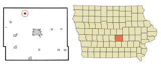
Hamilton County is a county located in the U.S. state of Iowa. As of the 2020 census, the population was 15,039. The county seat is Webster City. The county was named to honor William W. Hamilton, a President of the Iowa State Senate.

<span class="mw-page-title-main">Boone County, Iowa</span> County in Iowa, United States

Boone County is a county in the U.S. state of Iowa. As of the 2020 census, the population was 26,715. Its county seat is Boone.

<span class="mw-page-title-main">Fraser, Iowa</span> City in Iowa, United States

Fraser is a city in Dodge Township, Boone County, Iowa, United States. The population was 101 at the time of the 2020 census. It is part of the Boone, Iowa Micropolitan Statistical Area, which is a part of the larger Ames–Boone Combined Statistical Area. The city is located along the Des Moines River.

<span class="mw-page-title-main">Ventura, Iowa</span> City in Iowa, United States

Ventura is a city in Cerro Gordo County, Iowa, United States. The population was 711 at the time of the 2020 census. It is part of the Mason City Micropolitan Statistical Area. Ventura is located on the northeastern basin of Clear Lake, making it an area with many lakeside areas.

<span class="mw-page-title-main">Decatur City, Iowa</span> City in Iowa, United States

Decatur City is a city in Decatur County, Iowa, United States. The population was 175 at the time of the 2020 census.

<span class="mw-page-title-main">Latimer, Iowa</span> City in Iowa, United States

Latimer is a city in Franklin County, Iowa, United States. The population was 477 at the time of the 2020 census.

<span class="mw-page-title-main">Ellsworth, Iowa</span> City in Iowa, United States

Ellsworth is a city in Hamilton County, Iowa, United States. The population was 508 at the time of the 2020 census.

<span class="mw-page-title-main">Kamrar, Iowa</span> City in Iowa, United States

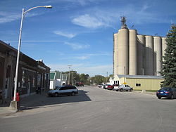
Kamrar is a city in Hamilton County, Iowa, United States. The population was 179 at the time of the 2020 census.

<span class="mw-page-title-main">Randall, Iowa</span> City in Iowa, United States

Randall is a city in Hamilton County, Iowa, United States. The population was 154 at the time of the 2020 census.

<span class="mw-page-title-main">Webster City, Iowa</span> City in Iowa, United States

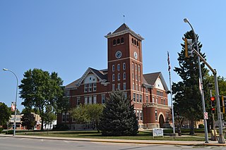
Webster City is a city in Hamilton County, Iowa, United States. The population was 7,825 at the 2020 census. It is the county seat of Hamilton County. Webster City is known as 'Boone River Country', as the Boone River meanders along the east side of the city.

<span class="mw-page-title-main">Williams, Iowa</span> City in Iowa, United States

Williams is a city in Hamilton County, Iowa, United States. The population was 307 at the time of the 2020 census. Williams is a regional center of wind power generation.

<span class="mw-page-title-main">Union, Iowa</span> City in Iowa, United States

Union is a city in Hardin County, Iowa, United States. The population was 399 at the time of the 2020 census.

<span class="mw-page-title-main">Baxter, Iowa</span> City in Iowa, United States

Baxter is a city in Jasper County, Iowa, United States. Baxter is located 33 miles (53 km) northeast of Des Moines. The population was 962 at the 2020 census.

<span class="mw-page-title-main">Pleasant Plain, Iowa</span> City in Iowa, United States

Pleasant Plain is a city in northeast Penn Township, Jefferson County, Iowa, United States. At the time of the 2020 census, the population was 84.

<span class="mw-page-title-main">Huxley, Iowa</span> City in Iowa, United States

Huxley is a city in Story County, Iowa, United States. The population was 4,244 at the time of the 2020 census. It is part of the Ames, Iowa Metropolitan Statistical Area, which is a part of the larger Ames-Boone, Iowa Combined Statistical Area.

<span class="mw-page-title-main">Dayton, Iowa</span> City in Iowa, United States

Dayton is a city in Webster County, Iowa, United States. The population was 772 at the time of the 2020 census.

<span class="mw-page-title-main">Moorland, Iowa</span> City in Iowa, United States

Moorland is a small town in Webster County, Iowa, United States. The population was 168 at the time of the 2020 census.

<span class="mw-page-title-main">Stratford, Iowa</span> City in Iowa, United States

Stratford is a city in Hamilton and Webster counties in the U.S. state of Iowa. The population was 707 at the time of the 2020 census.

References

  1. "2020 U.S. Gazetteer Files". United States Census Bureau. Retrieved March 16, 2022.
  2. 1 2 "2020 Census State Redistricting Data". census.gov. United states Census Bureau. Retrieved August 12, 2021.
  3. "US Gazetteer files: 2010, 2000, and 1990". United States Census Bureau. February 12, 2011. Retrieved April 23, 2011.
  4. "US Gazetteer files 2010". United States Census Bureau. Archived from the original on January 25, 2012. Retrieved May 11, 2012.
  5. "Census of Population and Housing". Census.gov. Retrieved June 4, 2015.
  6. "U.S. Census website". United States Census Bureau . Retrieved May 11, 2012.
  7. "U.S. Census website". United States Census Bureau . Retrieved January 31, 2008.
  8. "Webster City" (PDF). Iowa Department of Education . Retrieved April 5, 2020. - Map of district prior to merger with Northeast Hamilton
  9. "Northeast Hamilton" (PDF). Iowa Department of Education. Archived from the original (PDF) on April 27, 2018. Retrieved April 5, 2020.
  10. "Iowa Educational Directory 2019-2020 School Year" (PDF). Iowa Department of Education. p. 175. Archived from the original (PDF) on April 5, 2020. Retrieved April 5, 2020. (PDF p. 177/186) - From section "REORGANIZATION & DISSOLUTION ACTIONS SINCE 1965-66"
  11. "Northeast Hamilton". Webster City Community School District . Retrieved April 5, 2020.