
Mount Adams, known by some Native American tribes as Pahto or Klickitat, is a potentially active stratovolcano in the Cascade Range. Although Adams has not erupted in more than 1,000 years, it is not considered extinct. It is the second-highest mountain in Washington, after Mount Rainier.

The North Cascades are a section of the Cascade Range of western North America. They span the border between the Canadian province of British Columbia and the U.S. state of Washington and are officially named in the U.S. and Canada as the Cascade Mountains. The portion in Canada is known to Americans as the Canadian Cascades, a designation that also includes the mountains above the east bank of the Fraser Canyon as far north as the town of Lytton, at the confluence of the Thompson and Fraser Rivers.
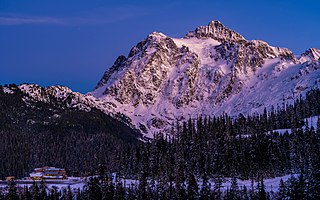
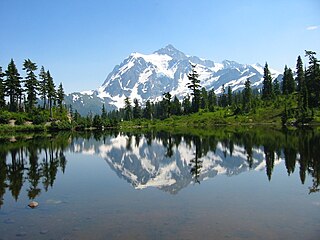
Mount Shuksan is a glaciated massif in the North Cascades National Park. Shuksan rises in Whatcom County, Washington immediately to the east of Mount Baker, and 11.6 miles (18.7 km) south of the Canada–US border. The mountain's name Shuksan is derived from the Lummi word [šéqsən], said to mean "high peak". The highest point on the mountain is a three-sided peak known as Summit Pyramid.
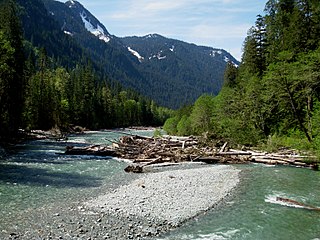
The Baker River is an approximately 30-mile (48 km), southward-flowing tributary of the Skagit River in northwestern Washington in the United States. It drains an area of the high North Cascades in the watershed of Puget Sound north of Seattle, and east of Mount Baker. With a watershed of approximately 270 square miles (700 km2) in a complex of deep valleys partially inside North Cascades National Park, it is the last major tributary of the Skagit before the larger river reaches its mouth on Skagit Bay. The river flows through Concrete, Washington, near its mouth and has two hydroelectric dams owned by Puget Sound Energy.
There are four prominent waterfalls in the basin of a short tributary of Sulphide Creek, on the southeast flank of 9,127-foot (2,781m) Mount Shuksan in North Cascades National Park, Washington. Seahpo Peak Falls and Cloudcap Falls, the taller two of the three, are located on separate streams that converge and plunge over Rockflow Canyon Falls. The unnamed outlet stream from these waterfalls flows into Sulphide Creek, which flows into the Baker River. Another waterfall is Jagged Ridge Falls, on a tributary of the unnamed stream.
Blum Creek is a small glacial tributary of the Baker River in Washington state, in the United States. It is sourced from the Hagan Glacier and another unnamed glacier on the north face of Mount Blum, and flows approximately 1.5 miles (2.4 km) from there to its mouth at the Baker River. Hagan Glacier is located below Mount Blum and the creek is also fed by runoff from the Blum Lakes, a set of six lakes south of Bacon Peak. The creek joins the Baker River two drainages downstream of Sulphide Creek, another Baker River glacial tributary. Blum Creek forms the waterfall Blum Basin Falls as it tumbles down a 1,680-foot (510 m) glacial cliff. The creek's watershed is an overwintering location for the local Rocky mountain goats.

Sulphide Creek Falls is a tall, moderately large volume waterfall within North Cascades National Park in Washington state that is one of the tallest waterfalls in North America. The falls drop from Sulphide Lake on the southeast side of Mount Shuksan down a narrow flume-like canyon to a broad basin below. Because of the narrow, twisting shape of the canyon the waterfall is exceptionally difficult to see from ground-level perspectives. The total vertical drop of the waterfall is in the range of 2,100 feet (640 m) to 2,200 feet (670 m) feet, but it has not yet been accurately measured. Foot access to the bottom of the waterfall involves 2.5 miles (4.0 km) of off-trail travel in extremely brushy terrain and several potentially dangerous fords of a large stream.

Eagle Creek is a tributary of the Columbia River in Multnomah and Hood River counties in the U.S. state of Oregon. It cuts through a narrow canyon in its 3,200 feet (980 m) descent to the Columbia River Gorge and is known for its concentration of 13 waterfalls in about 5 miles (8.0 km) distance. Eight major falls are on Eagle Creek and the East Fork Eagle Creek itself, while five are on its tributaries.
There are multiple waterfalls in the basin of the North Fork Cascade River, a river in the North Cascades of Washington that drains to the Cascade River. Many of these are taller than the more famous waterfalls in North America, but do not receive much attention due to their remoteness.

Mount Blum, or Mount Bald, is a 7,685-foot (2,342 m) summit of the North Cascades range in Washington state, on the western edge of North Cascades National Park. It is the highest summit of a string of mountain peaks located east of Mount Shuksan and west of the Picket Range. Two small active glaciers rest on its northern flank. Mount Blum was named after John Blum, a United States Forest Service fire patrol pilot who perished in a plane crash near Snoqualmie Pass in 1931.

Mount Triumph is a summit in the North Cascades range of Washington state. Located approximately 5.5 miles (8.9 km) west-northwest of the town of Newhalem, it was named by Lage Wernstedt, a surveyor with the U.S. Forest Service. A significant peak in North Cascades National Park, Mount Triumph is one of its "outstanding sights" and is well known among regional climbers for its lack of easy climbing routes to the summit. Despite its moderate elevation, its local relief is dramatic. With the terrain deeply dissected by the valleys of Bacon Creek on the west and Goodell Creek on the east, it rises 1 mile (1.6 km) in less than 2 miles (3.2 km) on the latter side.

The geography of the North Cascades describes a range of rugged mountains in British Columbia, Canada and Washington, United States. In Canada, the range is officially named the Cascade Mountains but is commonly referred to as the Canadian Cascades.
The valley of the West Fork Foss River contains a fair amount of waterfalls. The river heads in a series of large lakes: Big Heart Lake, Angeline Lake, and Otter Lake- which form spectacular waterfalls as they plunge down to Delta Lake. On the valley walls downstream of Delta Lake, are found even more waterfalls.
Sulphide Creek is a 2.5-mile (4.0 km) glacial tributary of the Baker River in Whatcom County in the U.S. state of Washington, draining a steep and narrow canyon on the southeast flank of Mount Shuksan, inside North Cascades National Park. Although called a creek, it is river-like due to its high volume. The creek is fed by the "massive" Sulphide and Crystal glaciers above Sulphide Lake and it runs east collecting several small tributaries before flowing into the Baker River at elevation 869 feet (265 m). There are several very tall waterfalls occurring on the creek and its tributaries, the largest of which is Sulphide Creek Falls.
Shannon Creek is a short tributary to the Baker River in Whatcom County, Washington, near the southwest border of North Cascades National Park. It rises in two forks a few miles south of Mount Shuksan; the glacier-fed north fork begins at elevation 5,016 feet (1,529 m), and the non-glacial south fork begins at 2,611 feet (796 m). Roughly halfway through its length, the two forks join and then flow into Baker Lake reservoir, at elevation 725 feet (221 m). Shannon Creek joins the Baker several miles downstream of Sulphide Creek and upstream of Swift Creek, a much larger south-flowing drainage.
Seahpo Peak is a subsidiary peak of Mount Shuksan, which rises in the U.S. state of Washington. It is located about 2 miles (3.2 km) east of the main peak of Shuksan and rises to about 7,441 feet (2,268 m). It is located in North Cascades National Park and is part of the North Cascades range.

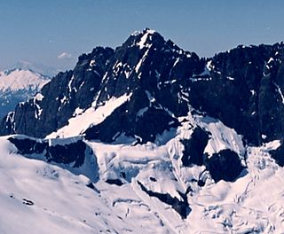
Crystal Glacier is in North Cascades National Park in the U.S. state of Washington, on the south slopes of Mount Shuksan. Descending 1.25 mi (2.01 km) from just east of the summit of Mount Shuksan, near its origination point, Crystal Glacier is connected to the larger Sulphide Glacier to the west. Crystal Glacier descends from 8,200 to 5,800 ft, and is also connected to East Nooksack Glacier as well as Hanging Glacier near it uppermost margins. Both Crystal and Sulphide Glaciers have a series of 300-to-1,000-foot high cascades which are collectively referred to as Sulphide Basin Falls. Below these cascades lies Sulphide Lake, which empties over Sulphide Creek Falls, one of the highest waterfalls in North America with a nearly 2,200 ft (670 m) drop.
Sulphide Glacier is in North Cascades National Park in the U.S. state of Washington, on the south slopes of Mount Shuksan. Descending 1.85 mi (2.98 km) from the summit tower of Mount Shuksan, it is connected to Crystal Glacier to the east. Sulphide Glacier descends from 8,600 to 5,600 ft. Sulphide Glacier is along the route taken when Mount Shuksan was first climbed in 1906. Both Sulphide and Crystal Glaciers have a series of 300-to-1,000-foot high cascades which are collectively referred to as Sulphide Basin Falls. Below these cascades lies Sulphide Lake, which empties over Sulphide Creek Falls, one of the highest waterfalls in North America with a nearly 2,200 ft (670 m) drop.
Blum Lakes are located in North Cascades National Park, in the U. S. state of Washington. Consisting of approximately six cirque lakes immediately southwest of Mount Blum, the Blum Lakes are not near any maintained trails. Outflow from the lakes feeds into a tributary of Blum Creek. Nearby the Blum Basin Falls plunges 1,680 ft (510 m) along another tributary of Blum Creek.
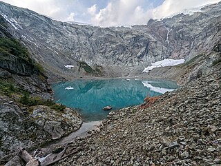
Sulphide Lake is located in North Cascades National Park, in the U. S. state of Washington. Sulphide Lake lies in a cirque on the southeast slopes of Mount Shuksan. Several major cascades drop as much as 1,000 ft (300 m) into Sulphide Lake including Sulphide Basin Falls which is from melt off the Sulphide Glacier. After Sulphide Creek drains from Sulphide lake, it then plunges at least 2,000 ft (610 m) over a series of cascades called Sulphide Creek Falls, which is one of the tallest waterfalls in the U.S.
