Related Research Articles

The Columbia River Gorge is a canyon of the Columbia River in the Pacific Northwest of the United States. Up to 4,000 feet (1,200 m) deep, the canyon stretches for over eighty miles (130 km) as the river winds westward through the Cascade Range, forming the boundary between the state of Washington to the north and Oregon to the south. Extending roughly from the confluence of the Columbia with the Deschutes River in the east down to the eastern reaches of the Portland metropolitan area, the water gap furnishes the only navigable route through the Cascades and the only water connection between the Columbia Plateau and the Pacific Ocean. It is thus the route of Interstate 84, U.S. Route 30, Washington State Route 14, and railroad tracks on both sides.

Prospect State Scenic Viewpoint, is a state park south of the community of Prospect on Oregon Route 62 in Jackson County, in the U.S. state of Oregon. It was formerly known as Mill Creek Falls Scenic Area, a private hiking area that was developed by Willamette Industries along the Rogue River. Both Mill Creek Falls and Pearsony Falls are contained within the area, with Barr Creek Falls close by.

Raven Cliff Falls are located in White County, Georgia on a creek that joins Dodd Creek. The waterfall consists of three drops, a 60-foot (18 m) drop, followed by a 20-foot (6.1 m) drop into a deep pool, followed by a cascade of 20 feet (6.1 m) to Dodd Creek. The waterfall is an unusual double cascade flowing down through a fissure in a massive granite outcrop. There are also three other major waterfalls located on Dodd Creek, with the largest having a 70-foot (21 m) drop.
Foss River Falls is a 650-foot (200 m) drop on the West Fork Foss River in the Alpine Lakes Wilderness Area, King County, Washington. Its sources are at Delta Lake, and the 70-foot (21 m)-wide drop flows year-round. The waterfall is split into two parts. Each part is split into several tiers.
Shoestring Falls is a waterfall, about 1,000 feet (300 m) high, fed by an unnamed stream coming from Malachite Glacier in the Alpine Lakes Wilderness Area, King County, Washington, United States. It is 20 feet (6.1 m) in breadth and flows year-round, but is at peak flow May to July. It drops down the mountainside in five distinct tiers, with the two main tiers totaling about 700 feet (210 m). It is at 47.63127°N 121.31881°W.
Jordan Creek Falls drops 588 feet (179 m) along Jordan Creek in Skagit County, Washington. The cascade has a run of 250 feet (76 m) and is fed by two large lakes and a large watershed. The falls' elevation is at 3,086 feet (941 m).
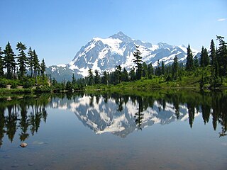
There are four prominent waterfalls in the basin of a short tributary of Sulphide Creek, on the southeast flank of 9,127-foot (2,781m) Mount Shuksan in North Cascades National Park, Washington. Seahpo Peak Falls and Cloudcap Falls, the taller two of the three, are located on separate streams that converge and plunge over Rockflow Canyon Falls. The unnamed outlet stream from these waterfalls flows into Sulphide Creek, which flows into the Baker River. Another waterfall is Jagged Ridge Falls, on a tributary of the unnamed stream.
Berdeen Falls is a series of three waterfalls located in Whatcom County, Washington. The 850-foot (260 m) falls are on a stretch of Bacon Creek downstream of Berdeen Lake.The drops include a 400-foot (120 m) horsetail, a 200-foot (61 m) bedrock slide, and a 250-foot (76 m) plunge waterfall.
Wy'east Falls is a waterfall on a small tributary of Eagle Creek in Hood River County, Oregon, U.S.
Walupt Creek Falls is a relatively obscure, but massive waterfall on Walupt Creek, a large tributary of the Cispus River in Lewis County, Washington, at an elevation of 3,500 feet (1,100 m). The falls cascade 221 feet (67 m) down a bedrock cliff in two tiers, with an average breadth of 204 feet (62 m), a maximum breadth of 267 feet (81 m) and an average flow of over 150 cubic feet (4.2 m3) per second. The creek begins the drop by falling down a 10 feet (3.0 m) cascade, then impacts a large, bell-shaped dome and spreads into a wide fan, dropping 200 feet (61 m). The final drop is a gently sloping slide that flows directly into the Cispus River. The feeder river, Walupt Creek, is sourced directly from Walupt Lake which provides a consistent flow throughout the year. The drainage basin of the river is also fairly large.
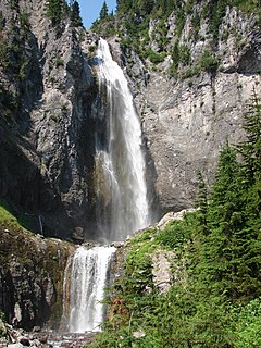
Comet Falls is a tall waterfall located on Van Trump Creek in Pierce County, Washington. The falls are thought to be the best in the Mount Rainier region.
Big Heart Falls is a waterfall on the outlet stream of Big Heart Lake, which eventually flows into the Skykomish River, in King County, Washington. It is located between the outlet of Big Heart Lake and the inlet of Delta Lake. The falls are said to drop approximately 1,268 feet (386 m).

Eagle Creek is a tributary of the Columbia River in Multnomah and Hood River counties in the U.S. state of Oregon. It cuts through a narrow canyon in its 3,200 feet (980 m) descent to the Columbia River Gorge and is known for its concentration of 13 waterfalls in about 5 miles (8.0 km) distance. Eight major falls are on Eagle Creek and the East Fork Eagle Creek itself, while five are on its tributaries.
Whinnimic Falls is a waterfall in the headwaters of Lemah Creek in the Alpine Lakes Wilderness Area. It is set in a narrow valley below Lemah Mountain. The falls are one of two in the valley, the other being the smaller Upper Lemah Valley Falls. Whinnimic Falls plunges about 350 feet (110 m) off a vertical cliff, onto a valley floor dotted with ponds and grassy meadows. The stream heads in two tarns and the remains of a small glacier.
The Paradise River in Washington state, United States, is known for having a total of eight major waterfalls.
The valley of the West Fork Foss River contains a fair amount of waterfalls. The river heads in a series of large lakes: Big Heart Lake, Angeline Lake, and Otter Lake- which form spectacular waterfalls as they plunge down to Delta Lake. On the valley walls downstream of Delta Lake, are found even more waterfalls.

Sulphide Creek is a 2.5-mile (4.0 km) glacial tributary of the Baker River in Whatcom County in the U.S. state of Washington, draining a steep and narrow canyon on the southeast flank of Mount Shuksan, inside North Cascades National Park. Although called a creek, it is river-like due to its high volume. The creek is fed by the "massive" Sulphide and Crystal glaciers above Sulphide Lake and it runs east collecting several small tributaries before flowing into the Baker River at elevation 869 feet (265 m). There are several very tall waterfalls occurring on the creek and its tributaries, the largest of which is Sulphide Creek Falls.
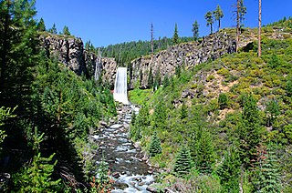
Tumalo Falls is a 97-foot (30 m) waterfall on Tumalo Creek, in the Cascade Range west of Bend in the U.S. state of Oregon. Additional waterfalls are upstream along Tumalo Creek and a tributary, Bridge Creek and its Bridge Creek Falls. All of these falls are within the Deschutes National Forest.
Upper Chush Falls is a 200-foot (61 m) waterfall on Whychus Creek, in the Cascade Range southwest of Sisters in the U.S. state of Oregon. Chush Falls, a 50-foot (15 m) waterfall, is further downstream on the same creek. Lying between Chush and Upper Chush is a third waterfall, The Cascade. These and several other falls on tributaries in the vicinity are within the Three Sisters Wilderness. The Northwest Waterfall Survey lists the fall's average flow at 40 cubic feet per second (1.1 m3/s). The highest flows occur between May and August.
The Koma Kulshan Project is a 13.3 MW run-of-the-river hydroelectric generation facility on the slopes of Mount Baker, a stratovolcano in Washington state's North Cascades. The project commenced commercial operation in October 1990, and is owned by a Covanta Energy–Atlantic Power joint venture. It supplies Puget Sound Energy via a Power Supply Agreement (PSA) contract. Its single turbine is a Pelton wheel supplied by Sulzer Escher Wyss.
References
- ↑ "Boston Creek Falls". Waterfalls of the Pacific Northwest. Retrieved 2009-03-13.
- ↑ "Torment Falls". Waterfalls of the Pacific Northwest. Retrieved 2009-03-14.
- ↑ "Roush Creek Falls". Waterfalls Northwest. Retrieved 2009-03-14.
- ↑ "Johannesburg Falls". Waterfalls of the Pacific Northwest. Retrieved 2009-03-14.
- ↑ "Tallest and Largest Waterfalls at the World Waterfall Database".
- ↑ "Morning Star Falls". Waterfalls of the Pacific Northwest. Retrieved 2009-03-14.
- ↑ "Gilbert Falls". Waterfalls of the Pacific Northwest. Retrieved 2009-03-14.