Blythewood, South Carolina | |
---|---|
Coordinates: 34°13′5″N80°59′5″W / 34.21806°N 80.98472°W | |
Country | United States |
State | South Carolina |
Counties | Richland, |
Area | |
• Total | 10.71 sq mi (27.74 km2) |
• Land | 10.63 sq mi (27.53 km2) |
• Water | 0.08 sq mi (0.22 km2) |
Elevation | 505 ft (152 m) |
Population | |
• Total | 4,772 |
• Density | 448.96/sq mi (173.35/km2) |
Time zone | UTC-5 (EST) |
• Summer (DST) | UTC-4 (EDT) |
ZIP code | 29016 |
Area codes | 803, 839 |
FIPS code | 45-07255 [4] |
GNIS feature ID | 1245688 [2] |
Website | www |
Blythewood is a town in Richland and Fairfield counties, South Carolina, United States. It is a suburb of Columbia, South Carolina. The 2020 United States census puts the population at 4,772. [5] It is part of the Columbia, South Carolina, Metropolitan Statistical Area. It is located around 15 miles (24 kilometers) from downtown Columbia.
Blythewood Road is one of the main thoroughfares, intersecting Interstate 77 at Exit 27. U.S. Route 21 also goes through Blythewood, intersecting Interstate 77 at exit 24.
Blythewood was originally named "Doko", a Native American term for a watering place. The town was named after Doko Depot, which was a stop along the railroad that ran between Charlotte and Columbia. In 1865, this railroad was destroyed by General Sherman. The town was rebuilt, and changed its name to Blythewood in 1877, after a local school called The Blythewood Female Institute. The school was later renamed "Blythewood Academy". [6]
The George P. Hoffman House, built in 1855, is the oldest extant house in Blythewood and is used as the city hall. [6] It was added to the National Register of Historic Places in 1986. [7]
Blythewood is located in the Piedmont region of South Carolina.
According to the United States Census Bureau, the town has a total area of 9.8 square miles (25.3 km2), of which 9.7 square miles (25.1 km2) is land and 0.077 square miles (0.2 km2), or 0.79%. is water. [8]
Climate is characterized by warm temperatures and moderate precipitation throughout the year. The Köppen Climate Classification subtype for this climate is "Cfa" (Humid Subtropical Climate). [9]
Climate data for Blythewood | |||||||||||||
---|---|---|---|---|---|---|---|---|---|---|---|---|---|
Month | Jan | Feb | Mar | Apr | May | Jun | Jul | Aug | Sep | Oct | Nov | Dec | Year |
Mean daily maximum °C (°F) | 12 (54) | 14 (58) | 19 (66) | 24 (75) | 28 (82) | 31 (88) | 33 (91) | 32 (89) | 29 (84) | 24 (75) | 19 (66) | 14 (57) | 23 (74) |
Mean daily minimum °C (°F) | 0 (32) | 2 (35) | 6 (42) | 10 (50) | 15 (59) | 19 (66) | 21 (70) | 21 (69) | 17 (63) | 11 (52) | 6 (43) | 2 (35) | 11 (51) |
Average precipitation mm (inches) | 110 (4.2) | 94 (3.7) | 120 (4.6) | 79 (3.1) | 84 (3.3) | 120 (4.6) | 130 (5.2) | 110 (4.5) | 94 (3.7) | 81 (3.2) | 74 (2.9) | 86 (3.4) | 1,180 (46.4) |
Average precipitation days | 10 | 9 | 9 | 8 | 8 | 9 | 10 | 9 | 8 | 6 | 7 | 9 | 103 |
Source: Weatherbase [10] |
Census | Pop. | Note | %± |
---|---|---|---|
1980 | 922 | — | |
1990 | 1,643 | 78.2% | |
2000 | 2,003 | 21.9% | |
2010 | 2,034 | 1.5% | |
2020 | 4,772 | 134.6% | |
U.S. Decennial Census [11] [ failed verification ] 2020 [5] [3] |
Race | Num. | Perc. |
---|---|---|
White (non-Hispanic) | 2,333 | 48.89% |
Black or African American (non-Hispanic) | 1,851 | 38.79% |
Native American | 13 | 0.27% |
Asian | 115 | 2.41% |
Pacific Islander | 6 | 0.13% |
Other/Mixed | 230 | 4.82% |
Hispanic or Latino | 224 | 4.69% |
As of the 2020 United States census, there were 4,772 people, 1,057 households, and 920 families residing in the town. [5]
As of the census of 2010, there were 3,148 people, 996 households residing in the town. The population density was 209.7 inhabitants per square mile (81.0/km2). The average median age was 39.3 The racial makeup of the town was 55% White, 41% African American, and 1.0% Asian. Hispanic or Latino of any race were 3.0% of the population. [5]
There were 723 households, out of which 42.5% had children under the age of 18 living with them, 71.0% were headed by married couples living together, 9.4% had a female householder with no husband present, and 15.9% were non-families. 13.4% of all households were made up of individuals, and 4.6% were someone living alone who was 65 years of age or older. The average household size was 2.81 and the average family size was 3.08. [13]
In the town, the population was spread out, with 28% below the age of 19, 15% from 20 to 29, 8% 30-39, 16% 40-49, 18% 50-59 and 15% who were 60 years of age or older. The median age was 39.3 years. 49% male and 51% female. [5]
The estimated median annual income for a household in the town was $90,444. The per capita income for the town was $38,077. About 1.4% of the population were below the poverty line, including 0.0% of those under the age of 18. [5]
The US Headquarters for Spirax-Sarco Engineering is headquartered in Blythewood.
A $2 billion Scout Motors electric vehicle plant is planned. The Volkswagen subsidiary plans to build a 1,100-acre site that will employ 4,000 people and produce 200,000 vehicles annually by the end of 2026. [14]
Blythewood has a public library, a branch of the Richland County Library. [15]
The schools in Richland School District 2 located directly in Blythewood are as follows:
Richland County is located in the U.S. state of South Carolina. As of the 2020 census, its population was 416,147, making it the second-most populous county in South Carolina, behind only Greenville County. The county seat and largest community is Columbia, the state capital. The county was established on March 12, 1785. Richland County is part of the Columbia, SC Metropolitan Statistical Area. In 2020, the center of population of South Carolina was located in Richland County, in the city of Columbia. The county is also the location of the geographic center of South Carolina, southeast of Columbia.
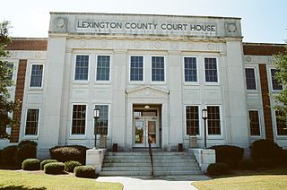
Lexington County is a county located in the U.S. state of South Carolina. As of the 2020 census, the population was 293,991. Its county seat and largest community is Lexington. The county was chartered in 1785 and was named in commemoration of Lexington, Massachusetts, the site of the Battle of Lexington in the American Revolutionary War. Lexington County is the sixth-most populous county in South Carolina by population and is part of the Columbia, SC Metropolitan Statistical Area. It is located in the Midlands region of South Carolina.
Fairfield County is a county located in the U.S. state of South Carolina. As of the 2020 census, its population was 20,948. Its county seat is Winnsboro.
College City is a former town in Lawrence County, Arkansas, United States. The population was 455 at the 2010 census. It is the site of Williams Baptist College, a four-year liberal arts college. The town merged with nearby Walnut Ridge effective January 1, 2017.
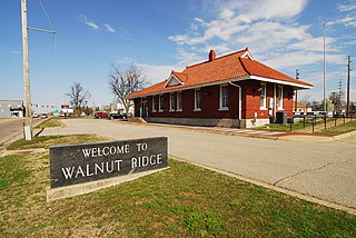
Walnut Ridge is a city in and the county seat of Lawrence County, Arkansas, United States. The population was 5,098 at the United States Census's 2019 estimate. Walnut Ridge lies immediately north of Hoxie. The two towns form a contiguous urban area with approximately 8,000 residents. Williams Baptist University is in College City, a formerly separate community that merged into Walnut Ridge in 2017.
Bellefonte is a town in New Castle County, Delaware, United States. According to the 2010 Census, the population of the town is 1,193.
Speedway is a town in Wayne Township, Marion County, Indiana, United States. The population was 13,952 at the 2020 census, up from 11,812 in 2010. Speedway, which is an enclave of Indianapolis, is the home of the Indianapolis Motor Speedway.
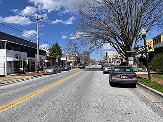
Alamance is a village in Alamance County, North Carolina, United States. It is part of the Burlington, North Carolina Metropolitan Statistical Area. The population was 951 at the 2010 census, up from 310 at the 2000 census.
Richlands is a town in Onslow County, North Carolina, United States. In the 2020 U.S. census, the population was 2,287. It is included in the Jacksonville, North Carolina Metropolitan Statistical Area. Incorporated on March 29, 1880, it was the first town in Onslow County to have its own library and museum. Richlands was also the first town in Onslow County to have a female mayor, Annette Hargett.
Amidon is a city in and the county seat of Slope County, North Dakota, United States.
Monessen is a city in southwestern Westmoreland County, Pennsylvania, United States, located along the Monongahela River. The population was 6,876 at the 2020 census.
Bamberg is a city in and the county seat of Bamberg County, South Carolina, United States. The population was 3,607 at the 2010 census.
Barnwell is a city in and county seat of Barnwell County, South Carolina, United States, located along U.S. Route 278. The population was 4,750 at the 2010 census.
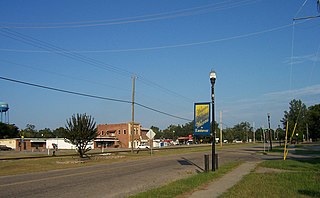
Eastover is a town in Richland County, South Carolina, United States. The population was 813 at the 2010 census, down from 830 in 2000. It is part of the Columbia, South Carolina, Metropolitan Statistical Area.
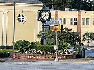
Forest Acres is a city in Richland County, South Carolina, United States. The population was 10,606 at the 2020 census. It is part of the Columbia, South Carolina, Metropolitan Statistical Area and is an enclave of the city of Columbia.
Portland is a city in Sumner and Robertson counties in Tennessee. The population was 11,486 in 2010 according estimates by the U.S. census bureau and in 2020 the population was 13,156. Portland is a part of the Nashville Metropolitan Statistical Area.
Silverton is a city in Briscoe County, Texas, United States. The population was 629 at the 2020 census.
Richlands is a town in Tazewell County, Virginia, United States. The population was 5,261 at the 2020 census. It is part of the Bluefield, WV-VA micropolitan area which has a population of 107,578.
West Richland is a city in Benton County, Washington. The population was 16,295 at the time of the 2020 census. The city is part of the Tri-Cities metropolitan area, whose principal cities are Richland, Kennewick, and Pasco.
Irmo is a town in Lexington and Richland counties, South Carolina, United States and a suburb of Columbia. It is part of the Columbia Metropolitan Statistical Area and is located 12 miles (19 km) northwest of the city center. The population of Irmo was 11,097 at the 2010 census.