Related Research Articles
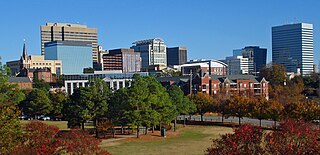
Columbia is the capital of the U.S. state of South Carolina. With a population of 136,632 as of the 2020 U.S. Census, it is the second-largest city in South Carolina. The city serves as the county seat of Richland County, and a portion of the city extends into neighboring Lexington County. It is the center of the Columbia metropolitan statistical area, which had a population of 829,470 and is the 72nd-largest metropolitan statistical area in the nation. The name Columbia is a poetic term used for the United States, derived from the name of Christopher Columbus, who explored for the Spanish Crown. Columbia is often abbreviated as Cola, leading to its nickname as "Soda City."

Richland County is located in the U.S. state of South Carolina. As of the 2010 census, the population was 384,504, making it the second-most populous county in South Carolina, behind only Greenville County. The 2019 estimated population was 415,759. The county seat and largest city is Columbia, the state capital. The county was founded in 1785. Richland County is part of the Columbia, SC Metropolitan Statistical Area. In 2010, the center of population of South Carolina was located in Richland County, in the city of Columbia.

Kershaw County is a county located in the U.S. state of South Carolina. As of the 2010 census, its population was 61,697. The county seat and largest city is Camden. The county was created in 1791 from parts of Claremont, Lancaster, Fairfield, and Richland counties. It is named for Col. Joseph Kershaw (1727–1791), an early settler and American Revolutionary War patriot.

Columbia County is a county located in the east central portion of the US state of Georgia. As of the 2010 census, the population was 124,035. The legal county seat is Appling, but the de facto seat of county government is Evans.

Blythewood is a suburb of Columbia, South Carolina, in Richland and Fairfield counties, South Carolina. 2020 estimates put the population at 4,446 up from 2,034 in 2010. Since 2000 it has had a population boom, going from 170 people in 2000 to a population of 2,034 in 2010, representing an increase of 1096%. It is part of the Columbia, South Carolina, Metropolitan Statistical Area. It is located around 15 miles from downtown Columbia.
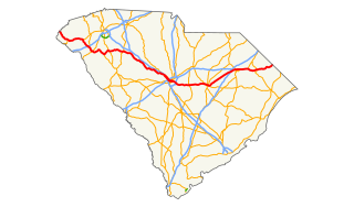
U.S. Route 378 is a spur of US 78 in the U.S. states of Georgia and South Carolina. The U.S. Highway runs 234.30 miles (377.07 km) from US 78, Georgia State Route 10, SR 17, and SR 47 in Washington, Georgia, east to US 501 Business in Conway, South Carolina. US 378 connects the Central Savannah River Area in both states with the Midlands and Pee Dee regions of South Carolina. The U.S. Highway's western portion, which connects Washington and Lincolnton in Georgia and McCormick, Saluda, and Lexington in South Carolina, is mainly a rural highway. US 378 is a major suburban and urban highway through Lexington and the South Carolina state capital, Columbia. The highway has a lengthy concurrency with US 76 between Columbia and Sumter and serves as a major route between the Midlands and the Myrtle Beach area, between which the highway has a business route through Lake City.
Richland County School District One, is a school district with its headquarters in the Stevenson Administration Building in Columbia, South Carolina.
Richland County School District Two is a nationally recognized school district located in suburban Columbia, South Carolina, United States, in the northeast section of Richland County. It is one of the fastest growing districts in South Carolina, with a current student population above 27,000. It operates 40 schools and centers, two district child development programs, two alternative schools, an adult/community center and several magnet centers and programs at all grade levels. The district offices are in an unincorporated area.
School District Five of Lexington and Richland Counties is a South Carolina school district encompassing a land area of approximately 196 square miles, (508 km2) roughly half of which is situated in each of Lexington and Richland Counties. Student enrollment is at 16,717 as of August 2005. The school district consists of the northern portion of Lexington County lying north of Lake Murray and the Saluda River and the northwestern portion of Richland County lying south of the Broad River. The School District is primarily a residential suburb located to the northwest of the city of Columbia, the capital city of South Carolina. Included in the District Five are the towns of Irmo and Chapin. The school district has three attendance areas: Chapin, Dutch Fork, and Irmo. District Five operates a total of 12 elementary schools, four middle schools, five high schools, and one alternative school. The interim Superintendent is Akil Ross, appointed in June 2021 following the sudden resignation of former superintendent Christina Melton at a board meeting on June 14 over conflicts with some school board members. The Chief Instructional Officer is Michael Guliano.

South Carolina Highway 544 (SC 544) is a 13.710-mile (22.064 km) major four-lane state highway in Horry County, South Carolina. It connects the Surfside Beach and Conway areas. The highway is sometimes known as Dick Pond Road in the Socastee area.

Hopkins is a census-designated place (CDP) in Richland County, South Carolina, United States, that was founded circa 1836 and named after John Hopkins. It is located 11 miles (18 km) southeast of downtown Columbia and is part of the Columbia Metropolitan Statistical Area. As of the 2010 census, the population of the Hopkins CDP was 2,882.
Interstate 77 (I-77) is a south–north Interstate highway, extending 91.2 miles (146.8 km) in the state of South Carolina, extending from the national southern terminus at an interchange with I-26 near Columbia, north to the North Carolina state line near Rock Hill and Charlotte, NC.
U.S. Route 76 (US 76) is an east–west U.S. highway in the U.S. state of South Carolina. Being one of the longest highways in the state, it connects the cities of Anderson, Columbia, Sumter and Florence.

The High Hills of Santee, sometimes known as the High Hills of the Santee, is a long, narrow hilly region in the western part of Sumter County, South Carolina. It has been called "one of the state's most famous areas". The High Hills of Santee region lies north of the Santee River and east of the Wateree River, one of the two rivers that join to form the Santee. It extends north almost to the Kershaw county line and northeasterly to include the former summer resort town of Bradford Springs. Since 1902 the town has been included in Lee County.
On April 29–30, 1924, an outbreak of at least 28 tornadoes—26 of which were significant, meaning F2 or stronger—affected the Southern United States. The tornadoes left 114 dead and at least 1,166 injured, mostly in the Carolinas, with 76 deaths in South Carolina alone, along with 16 in Georgia and 13 in Alabama. Killer tornadoes touched down from Oklahoma and Arkansas to Virginia. The deadliest tornado of the outbreak was a long-lived tornado family that produced F4 damage in rural portions of South Carolina, killing 53 people and injuring at least 534. The tornado is the deadliest ever recorded in South Carolina and is one of the longest-tracked observed in the state, having traveled 105 miles (169 km); some sources list a total path length of 135 mi (217 km), including the segment in Florence County, but this is now believed to have been a separate, F3 tornado.

Millwood is the site and ruins of an antebellum plantation house at 6100 Garner's Ferry Road, Columbia, South Carolina. Owned by Colonel Wade Hampton II and his wife Ann Fitzsimmons Hampton, it was the boyhood home of their first son Wade Hampton III and other children. He later became a Confederate general and later, South Carolina governor, and U.S. Senator.
South Carolina Highway 263 (SC 263) is a 5.250-mile (8.449 km) state highway in the U.S. state of South Carolina. The highway connects Eastover with rural areas of Richland County.
South Carolina Highway 764 (SC 764) is a 8.950-mile-long (14.404 km) state highway in the U.S. state of South Carolina. The highway connects rural areas of Richland County with Eastover.
South Carolina Highway 769 (SC 769) is a 9.590-mile-long (15.434 km) state highway in the U.S. state of South Carolina. The highway connects Gadsden and Horrell Hill.
Capitol View is an unincorporated part of Richland County, South Carolina, United States, consisting of several neighborhoods that are next to the city of Columbia, the state capital. The area was first listed as a census-designated place (CDP) prior to the 2020 census. Its 2020 its population was 4,653.
References
- 1 2 U.S. Geological Survey Geographic Names Information System: Horrell Hill, South Carolina
- ↑ Moore, John Hammond (1992). Columbia and Richland County: A South Carolina Community, 1740-1990. University of South Carolina Press. p. 38. ISBN 978-0-87249-827-3.
- ↑ Palmetto Place Names. Works Progress Administration. 1941. p. 58.
- ↑ "Horrell Hill Reunion To Rekindle Memories Schoolmates From 1897-1924 To Gather". The State. 24 March 1988.
