
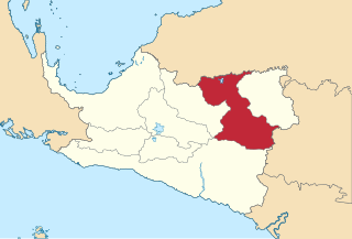
Merauke Regency is a regency in the far south of the Indonesian province of South Papua. It covers an area of 45,013.35 km2, and had a population of 195,716 at the 2010 Census and 230,932 at the 2020 Census; the official estimate as at mid 2023 was 243,722, comprising 126,508 males and 117,214 females. The administrative centre is the town of Merauke; this was projected since 2013 to become an independent city (kota) separate from Merauke Regency, but the alteration has been deferred. It is also the provincial capital of the province of South Papua, more specifically in Salor located in Kurik District. Merauke is the largest regency in Indonesia, with an area of 45,013.35 km2, slightly larger than Estonia.
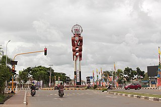
Merauke, also known as the District of Merauke, is a large town in South Papua, Indonesia. It is also the administrative centre of Merauke Regency. It is considered the easternmost city in Indonesia. The town was originally called Ermasoe. It is next to the Maro River where the Port of Merauke is located. As of the 2010 census, Merauke had a population of 87,634 which at the 2020 Census had increased to 102,351.

Asmat Regency is a regency (kabupaten) in the northwestern portion of the Indonesian province of South Papua. It is bounded to the southwest by the Arafura Sea, to the southeast and east by Mappi Regency, to the north by Highland Papua Province and to the northwest by Central Papua Province. It was split off from Merauke Regency on 12 November 2002.

Dogiyai Regency is one of the regencies (kabupaten) in the Indonesian province of Central Papua. It covers an area of 7,052.92 km2, and had a population of 84,230 at the 2010 Census and 116,206 at the 2020 Census; the official estimate as at mid 2022 was 119,815, comprising 62,373 males and 57,442 females. The administrative centre is the town of Kigamani.

Intan Jaya Regency is one of the regencies (kabupaten) in the Indonesian province of Central Papua; it was formed in 2008 from part of Paniai Regency. It covers an area of 3,922 km2, and had a population of 40,490 at the 2010 Census, but this greatly increased to 135,043 at the 2020 Census; the official estimate as at mid 2022 was 139,236. The administrative centre is the town of Sugapa.

Yalimo Regency is one of the regencies in the Indonesian province of Highland Papua. It covers an area of 4,320.29 km3, and had a population at the 2010 Census of 50,763 which doubled to reach 101,973 at the 2020 Census; the official estimate as at mid 2022 was 105,139. The administrative centre is at Elelim. The indigenous inhabitants of this well-forested mountainous area are the Yali people.

Yahukimo Regency is one of the regencies (kabupaten) in the Indonesian province of Highland Papua. It covers an area of 17,152 km2, and had a population of 164,512 at the 2010 Census, but this figure more than doubled to reach 350,880 at the 2020 Census; the official estimate as at mid 2022 was 361,776. The official administrative centre of Yahukimo Regency is at Sumohai, which is located 25 kilometres north of the town of Dekai, but - due to the lack of infrastructure in Sumohai - the actual administrative centre of the regency is in Dekai. The regency was formerly part of the Jayawijaya Regency, but was split off to become a separate regency on 11 December 2002.
Puncak Regency is one of the regencies (kabupaten) in the Indonesian province of Central Papua; it is not to be confused with Puncak Jaya Regency, which is within the same province, and from whose western districts those districts now forming Puncak Papua Regency were separated in 2008. It covers an area of 7,396.47 km2, and had a population of 93,218 at the 2010 Census and 114,741 at the 2020 Census; the official estimate as of mid-2022 was 116,279. The administrative centre is at Ilaga. The name of the regency is currently being changed to Puncak Papua Regency.

Paniai Regency is one of the regencies (kabupaten) in Central Papua Province of Indonesia. It is named after the Paniai Lakes. It covers an area of 6,525.25 km2, and had a population of 153,432 at the 2010 Census and 220,410 at the 2020 Census; the official estimate as of mid-2022 was 227,254 - comprising 124,260 males and 102,994 females. The administrative centre is the town of Enarotali, in East Paniai.

Nduga Regency is one of the regencies (kabupaten) in the Indonesian province of Highland Papua. Nduga Regency was created on 4 January 2008 by separation from Jayawijaya Regency in accordance with Law No. 6/2008. It covers an area of 12,941 km2, and had a population of 79,053 at the 2010 Census and 106,533 at the 2020 Census; the official estimate as at mid 2022 was 109,630 - comprising 59,587 males and 50,043 females. The administrative centre is at the town of Kenyam.

Mimika Regency is one of the regencies (kabupaten) in the Indonesian province of Central Papua. It covers an area of 21,693.51 km2, and had a population of 182,001 at the 2010 Census, but grew to 311,969 at the 2020 Census. The official estimate as of mid-2022 was 321,657. The administrative centre is the town of Timika, which lies within Mimika Baru District, which had 144,893 inhabitants in mid-2021.

Mappi Regency is a regency (kabupaten) in the Indonesian province of South Papua. It was split off from Merauke Regency on 12 November 2002. It covers an area of 25,609.94 km2, and had a population of 81,658 at the 2010 Census and 108,295 at the 2020 Census; the official estimate as at mid 2023 was 110,291. The administrative centre is the town of Kepi.

Mamberamo Raya Regency is one of the regencies (kabupaten) in Papua Province, Indonesia; it was created on 15 March 2007 from parts of Sarmi Regency and Waropen Regency. It covers an area of 23,813.91 km2, and had a population of 18,365 at the 2010 Census which had virtually doubled to 36,483 at the 2020 Census; the official estimate as at mid 2022 was 37,616. The administrative centre is at the town of Burmeso in Mamberamo Tengah District.

Central Mamberamo Regency is one of the regencies (kabupaten) in the Indonesian province of Highland Papua. It covers an area of 3,743.64 km2, and had a population of 39,537 at the 2010 Census and 50,685 at the 2020 Census. The official estimate as at mid 2022 was 51,719 - comprising 27,285 males and 24,434 females. The administrative centre is at Kobakma.

Keerom Regency is one of the regencies (kabupaten) in the Papua Province of Indonesia. It was formed from the eastern districts then within Jayapura Regency with effect from 12 November 2002. It covers an area of 9,365 km2, and had a population of 48,536 at the 2010 Census and 61,623 at the 2020 Census; the official estimate as at mid 2022 was 62,777. The regency's administrative centre is at Waris. It borders Green River Rural LLG and Amanab Rural LLG of Sandaun Province, Papua New Guinea.

Lanny Jaya Regency is a regency (kabupaten) located in the Indonesian province of Highland Papua. It covers an area of 6,077.4 km2, and had a population of 148,522 at the 2010 Census and 196,399 at the 2020 Census; the official estimate as at mid 2022 was 201,461. The administrative centre is the town of Tiom.

Pegunungan Bintang Regency or Bintang Mountains Regency is a regency in the Indonesian province of Highland Papua. It was created on 11 December 2002 from the north-eastern districts of Jayawijaya Regency. It covers an area of 15,683 km2, and had a population of 65,434 at the 2010 Census and 77,872 at the 2020 Census; the official estimate as at mid 2022 was 78,466 - comprising 42,362 males and 36,104 females. The administrative centre is the town of Oksibil.

Arfak Mountains Regency is a regency of the West Papua Province of Indonesia. It was formed in 2013 from the western districts of Manokwari Regency. The areas now comprised in the new regency had a population of 23,877 at the 2010 Census, which rose to 38,941 at the 2020 Census; the official estimate as at mid 2022 was 39,760. The administrative centre is the town of Anggi.
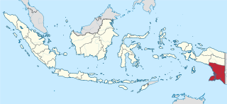
South Papua, officially the South Papua Province, is an Indonesian province located in the southern portion of Papua, following the borders of the Papuan customary region of Anim Ha. Formally established on 11 November 2022 and including the four most southern regencies that were previously part of the province of Papua and before 11 December 2002 had comprised a larger Merauke Regency, it covers a land area of 129,715.02 km2, about the same area as Pennsylvania. This area had a population of 513,617 at the 2020 Census, while the official estimate as at mid 2023 was 537,973, making it the least populous province in Indonesia.


