
Hobart ( HOH-bart; is the capital and most populous city of the island state of Tasmania, Australia. Located in Tasmania's south-east on the estuary of the River Derwent, it is the southernmost capital city in Australia. Despite containing nearly half of Tasmania's population, Hobart is the least-populated Australian state capital city, and second-smallest by population and area after Darwin if territories are taken into account. Its skyline is dominated by the 1,271-metre kunanyi / Mount Wellington, and its harbour forms the second-deepest natural port in the world, with much of the city's waterfront consisting of reclaimed land. The metropolitan area is often referred to as Greater Hobart, to differentiate it from the City of Hobart, one of the seven local government areas that cover the city. It has a mild maritime climate.

The River Derwent, also known as timtumili minanya in palawa kani, is a significant river and tidal estuary in Tasmania, Australia. It begins its journey as a freshwater river in the Central Highlands at Lake St Clair, descending over 700 metres (2,300 ft) across a distance of more than 200 kilometres (120 mi). At the settlement of New Norfolk in the Derwent Valley its waters become brackish, flowing through Hobart, the capital city of Tasmania, its seawater estuary eventually empties into Storm Bay and the Tasman Sea.

The Tasman Bridge is a prestressed concrete girder bridge connecting the Tasman Highway over the River Derwent in Hobart, Tasmania, Australia. When it opened on 29 March 1965, the Tasman was the longest prestressed concrete bridge in Australia, with a total length measuring 1,396 metres (4,580 ft), including approaches. The bridge provides a vital link between Hobart's city centre on the western shore and the City of Clarence on the eastern shore. Averaging 73,029 vehicle crossings per day, the bridge is the highest volume road section in Tasmania. It features five lanes of traffic including a central lane equipped for tidal flow operations and separated shared-use walkways on both sides, with ramp upgrades for improved access and cyclists completed in 2010.
Glenorchy is a suburb of Hobart, in the state of Tasmania, Australia. Glenorchy is bound by the River Derwent to the east, Mount Wellington to the west, Hobart City to the south and Brighton to the north. The city officially begins at Creek Road New Town, in Hobart's northern suburbs, and includes, Moonah, Derwent Park, Lutana, Goodwood, Montrose, Rosetta, Berriedale, Chigwell, Claremont and Austins Ferry. It is the seat of the local government area of the same name, the City of Glenorchy.
The Hobart Bridge was a floating arch bridge that crossed the River Derwent, connecting the eastern and western shores of the city of Hobart, Tasmania, Australia.

Glenorchy City Council is a local government body in Tasmania, and one of the five municipalities that constitutes the Greater Hobart Area. The Glenorchy local government area has a population of 50,411, covering the suburbs north of central Hobart on the western shore of the Derwent River, including its namesake suburb, Glenorchy.

Risdon Vale is an outer suburb of Hobart, capital of Tasmania, Australia on the eastern shore of the River Derwent, and adjacent to Risdon Cove, which was the site of the British colonisation of Van Diemen's Land.

The Bridgewater Bridge is a combined road and rail bridge that carries the Midland Highway and South Railway Line across the Derwent River in Hobart, Tasmania, Australia. This steel truss vertical lift bridge and specially-built causeway connect the Hobart suburbs of Bridgewater and Granton. The bridge was completed in 1946 and accommodates a two-lane highway, a single track railway and a grade-separated footpath.

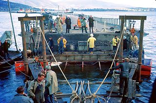
The Tasman Bridge disaster occurred on the evening of 5 January 1975, in Hobart, the capital city of Australia's island state of Tasmania, when the bulk carrier Lake Illawarra, travelling up the Derwent River, collided with several pylons of the Tasman Bridge and caused a large section of the bridge deck to collapse onto the ship and into the river below. Twelve people were killed, including seven crew on board Lake Illawarra, and the five occupants of four cars which fell 45 metres (150 ft) after driving off the bridge. Hobart was cut off from its eastern suburbs, and the loss of the road connection had a major social impact. The ship's master was officially penalised for inattention and failure to handle his vessel in a seamanlike manner.

The Derwent Entertainment Centre (DEC), known commercially as MyState Bank Arena since 2021, is Tasmania's largest indoor arena, serving as Hobart's primary location for large indoor sporting events, functions and live entertainment. Commissioned by the Tasmanian Government and the Glenorchy City Council, the DEC served as the home arena for the Hobart Devils in the NBL from 1989 until 1996, when the team's licence was revoked. Subsequently, between 1997 and 1998, ownership was transferred entirely to the City of Glenorchy, where it became a financial burden and incurred significant maintenance expenses for Glenorchy taxpayers, while seeing limited use. As the largest enclosed multipurpose venue in Tasmania, the DEC has hosted many Australian and international musical acts, including Kylie Minogue, Bob Dylan, Carole King, The Corrs, James Brown, Leonard Cohen, Tina Turner, Blondie and The Beach Boys.
The modern history of the Australian city of Hobart in Tasmania dates to its foundation as a British colony in 1804. Prior to British settlement, the area had been occupied definitively for at least 8,000 years, and possibly for as long as 35,000 years, by the semi-nomadic Mouheneener tribe, a sub-group of the Nuenonne, or South-East tribe. The descendants of theses indigenous Tasmanians now refer to themselves as 'Palawa'. Little is known about the region from prehistoric times. As with many other Australia cities, urbanisation has destroyed much of the archaeological evidence of indigenous occupation, although aboriginal middens are often still present in coastal areas.

SS Lake Illawarra was a handysize bulk carrier of 7,274 tons in the service of the Australian National Line. This ship is known for causing the Tasman Bridge disaster when she collided with pylon 19 of Hobart's giant high concrete arch style Tasman Bridge on the evening of 5 January 1975 at 9.27 pm, resulting in the deaths of 12 people.

Lutana is a residential locality in the local government area (LGA) of Glenorchy in the Hobart LGA region of Tasmania. The locality is about 3 kilometres (1.9 mi) south-east of the town of Glenorchy. The 2021 census recorded a population of 2,616 for the state suburb of Lutana. It is a suburb of Hobart. It is a large residential suburb located between the Brooker Highway and the River Derwent.
Dowsing Point is a residential locality in the local government area (LGA) of Glenorchy in the Hobart LGA region of Tasmania. The locality is about 2 kilometres (1.2 mi) north-east of the town of Glenorchy. The 2016 census recorded a population of 85 for the state suburb of Dowsing Point.

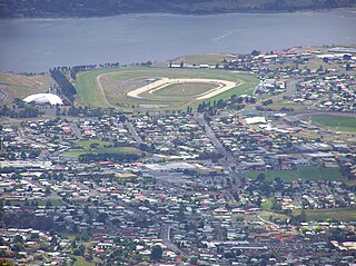
Elwick Racecourse is a Thoroughbred horse-racing venue located on Goodwood Road within Glenorchy, Tasmania, Australia. It is located in close proximity to the Brooker Highway, Hobart Showground, Derwent Entertainment Centre, Glenorchy Art and Sculpture Park and the River Derwent. The Racecourse has a picturesque outlook across the river, as well as being dominated by views of kunanyi / Mount Wellington. Elwick features at least 110 race meetings and 210 trial days a year, but is most well known for hosting the Hobart Cup.
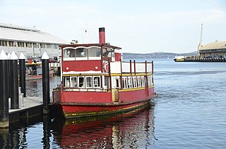
Ferries in Hobart are a form of public transport in the city of Hobart, Tasmania. Though for decades they had not provided a major alternative public transport service for commuters and tourists in Hobart across the Derwent River, a renewed ferry service began in 2021. This has resulted in a revival of ferry transport in Hobart, including long-term plans to expand the network.

Goodwood Road is a 4-lane link road that connects the City of Glenorchy to the City of Clarence in the greater area of Hobart, Tasmania. Using the Bowen Bridge the road travels over the River Derwent in semi-highway road layout. The road starts 10 km north of the Hobart CBD near the Hobart Showground on the Brooker Highway at Glenorchy, from there it travels east past the Elwick Racecourse, over the Bowen Bridge and connects to the East Derwent Highway at Otago. While the route the road takes is used far less than other major arterial roads in Hobart, commuters often depend on the road when major incidents occur on other major roads throughout Hobart.

Risdon Zinc Works is a major zinc refinery located in Lutana, a suburb of Hobart, Tasmania, Australia. The smelter is one of the world's largest in terms of production volume, producing over 280,000 tonnes annually of high-grade zinc, primarily as die-cast alloys and continuous galvanising-grade alloys. These products are exported for global markets and utilised in a wide range of industries and products, from building and infrastructure to transportation, business equipment, communications, electronics, and consumer goods. The facility produces zinc using the Roast, Leach, Electrowinning (RLE) method, creating leach byproducts, including cadmium, gypsum, copper sulphate, lead sulphate, sulphuric acid, paragoethite and leach concentrate. The refinery has been owned and operated by the global multi-metals business Nyrstar since 2007. Nyrstar Hobart works closely with the Nyrstar Port Pirie multi-metals smelter in South Australia. The facility is Tasmania's largest exporter, contributing 25% of the state's overall export value in 2013.

The Glenorchy Art and Sculpture Park (GASP) is a sculpture park and boardwalk in Glenorchy, Tasmania, Australia. Commencing at Montrose Foreshore Community Park, GASP follows Elwick Bay's foreshore, terminating at Wilkinsons Point. GASP is in close proximity to the MyState Bank Arena, Elwick Racecourse and the Museum of Old and New Art (MONA) in Berriedale.

The Blair Street Bridge is a concrete and steel girder bridge carrying the Lyell Highway through the township of New Norfolk across the River Derwent in Tasmania, Australia. Serving as a vital transportation link in the township's infrastructure, the bridge features a single carriageway with separated shared-use pathways on both sides. Completed in 1974, it is the fourth bridge to be constructed at New Norfolk, with the development aimed at withstanding valley floods before the establishment of the Meadowbank weirs.


