Bridgewater, Vermont

Last updated

Bridgewater, Vermont
Welcome to Bridgewater, Vermont.jpg
Bridgewater Fire and Rescue
Windsor County Vermont incorporated and unincorporated areas Bridgewater highlighted.svg
Location in Windsor County and the state of Vermont.
Usa edcp location map.svg
Red pog.svg
Bridgewater, Vermont
Location in the United States
Coordinates: 43°37′10″N72°40′19″W / 43.61944°N 72.67194°W / 43.61944; -72.67194
Country United States
State Vermont
County Windsor
Chartered1761
Settled1779
Organized1785
Area
  Total49.5 sq mi (128.3 km2)
  Land49.4 sq mi (128.0 km2)
  Water0.2 sq mi (0.4 km2)
Elevation
1,040 ft (317 m)
Population
 (2020)
  Total903
  Density18/sq mi (7.0/km2)
Time zone UTC-5 (Eastern (EST))
  Summer (DST) UTC-4 (EDT)
ZIP code
05034
Area code 802
FIPS code 50-08275 [1]
GNIS feature ID1462050 [2]

Bridgewater is a town in Windsor County, Vermont, United States. The population was 903 at the 2020 census. [3] Bridgewater contains the hamlets of Bridgewater Village, Bridgewater Corners, West Bridgewater, and Bridgewater Center (formerly called Briggs).

Contents

Geography

According to the United States Census Bureau, the town has a total area of 49.5 square miles (128.3 km2), of which 49.4 square miles (128.0 km2) is land and 0.15 square miles (0.4 km2), or 0.27%, is water. [4] The Ottauquechee River flows west to east through the town. [5] U.S. Route 4 follows the river, connecting Woodstock and White River Junction to the east with Rutland to the west. The Appalachian Trail passes through the town, running along the northern border.

Demographics

Historical population
CensusPop.Note
1790 293
1800 781166.6%
1810 1,12544.0%
1820 1,1250.0%
1830 1,31116.5%
1840 1,3634.0%
1850 1,311−3.8%
1860 1,292−1.4%
1870 1,141−11.7%
1880 1,084−5.0%
1890 1,1243.7%
1900 972−13.5%
1910 874−10.1%
1920 808−7.6%
1930 741−8.3%
1940 89520.8%
1950 9030.9%
1960 776−14.1%
1970 7830.9%
1980 86710.7%
1990 8953.2%
2000 9809.5%
2010 936−4.5%
2020 903−3.5%
U.S. Decennial Census [6]

As of the census [1] of 2000, there were 980 people, 395 households, and 250 families residing in the town. The population density was 19.8 people per square mile (7.6/km2). There were 582 housing units at an average density of 11.7 per square mile (4.5/km2). The racial makeup of the town was 98.47% White, 0.31% Native American, 0.51% Asian, and 0.71% from two or more races. Hispanic or Latino of any race were 0.10% of the population.

There were 395 households, out of which 27.8% had children under the age of 18 living with them, 57.5% were married couples living together, 4.6% had a female householder with no husband present, and 36.5% were non-families. 27.6% of all households were made up of individuals, and 10.9% had someone living alone who was 65 years of age or older. The average household size was 2.48 and the average family size was 3.08.

In the town, the population was spread out, with 23.1% under the age of 18, 5.6% from 18 to 24, 29.4% from 25 to 44, 28.7% from 45 to 64, and 13.3% who were 65 years of age or older. The median age was 41 years. For every 100 females, there were 102.9 males. For every 100 females age 18 and over, there were 102.7 males.

The median income for a household in the town was $39,107, and the median income for a family was $47,500. Males had a median income of $27,727 versus $22,857 for females. The per capita income for the town was $19,811. About 4.9% of families and 7.9% of the population were below the poverty line, including 9.0% of those under age 18 and 11.9% of those age 65 or over.

See also

Related Research Articles

<span class="mw-page-title-main">Windsor County, Vermont</span> County in Vermont, United States

Windsor County is a county located in the U.S. state of Vermont. As of the 2020 census, the population was 57,753. The shire town is the town of Woodstock. The county's largest municipality is the town of Hartford.

<span class="mw-page-title-main">Strafford, Vermont</span> Town in Vermont, United States

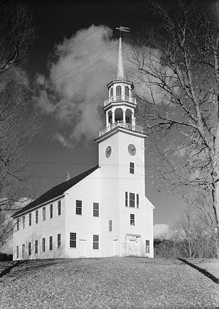
Strafford is a town in Orange County, Vermont, United States. The population was 1,094 at the 2020 census. The town of Strafford was created on August 12, 1761, by way of a royal charter which King George III of Great Britain issued to Governor Benning Wentworth of New Hampshire. The town was named after the Earl of Strafford. Its town house is one of the most famous in Vermont, sitting atop a hill at the end of the historic town common.

<span class="mw-page-title-main">Topsham, Vermont</span> Town in Vermont, United States

Topsham is a town in Orange County, Vermont, United States. The population was 1,199 at the 2020 census. It contains four villages: East Topsham, Topsham Four Corners, Waits River, and West Topsham.

<span class="mw-page-title-main">Vershire, Vermont</span> Town in Vermont, United States

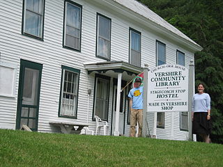
Vershire is a town in Orange County, Vermont, United States, created under Vermont Charter of August 3, 1781. The population was 672 at the 2020 census. The name Vershire is a portmanteau of Vermont and New Hampshire.

<span class="mw-page-title-main">Killington, Vermont</span> Town in Vermont, United States

Killington is a town in Rutland County, Vermont, United States. The population was 1,407 at the 2020 census. Killington Ski Resort and numerous vacation lodges are located here. The town was previously named Sherburne, but was renamed to its original name, "Killington", in 1999.

<span class="mw-page-title-main">Brookline, Vermont</span> Town in Vermont, United States

Brookline is a town in Windham County, Vermont, United States. The population was 540 at the 2020 census.

<span class="mw-page-title-main">Dover, Vermont</span> Town in Vermont, United States

Dover is a town in Windham County, Vermont, United States. The population was 1,798 at the 2020 census. It is famed for being the location of the Mount Snow ski area.

<span class="mw-page-title-main">Londonderry, Vermont</span> Town in Vermont, United States

Londonderry is a town in Windham County, Vermont, United States. It is bounded on the north by Landgrove and Weston, on the east by Windham, on the south by Jamaica and on the west by Winhall and Landgrove. The population was 1,919 in the 2020 census. The town contains the villages of Londonderry and South Londonderry.

<span class="mw-page-title-main">Andover, Vermont</span> Town in Vermont, United States

Andover is a town in Windsor County, Vermont, United States. The population was 568 at the 2020 census.

<span class="mw-page-title-main">Baltimore, Vermont</span> Town in Vermont, United States

Baltimore is a town located in Windsor County, Vermont, United States. As of the 2020 census, the population of Baltimore was recorded as 229.

<span class="mw-page-title-main">Hartford, Vermont</span> Town in Vermont, United States

Hartford is a town in Windsor County, Vermont, United States. It is on the New Hampshire border, at the intersection of Interstates 89 and 91. It is the site of the confluence of the White and Connecticut rivers; the Ottauquechee River also flows through the town. The town is composed of five unincorporated villages: Hartford, Quechee, West Hartford, White River Junction and Wilder. As of the 2020 census, the population was 10,686.

<span class="mw-page-title-main">Hartland, Vermont</span> Town in Vermont, United States

Hartland is a town in Windsor County, Vermont, United States. The population was 3,446 at the 2020 census. It includes the villages of Hartland, Hartland Four Corners, and North Hartland.

<span class="mw-page-title-main">Plymouth, Vermont</span> Town in Vermont, United States

Plymouth is a town in Windsor County, Vermont, United States. The population was 641 at the 2020 census. Calvin Coolidge, the 30th president of the United States, was born and raised in Plymouth and is buried there in the Plymouth Notch cemetery. The State of Vermont Division for Historic Preservation owns and maintains the Coolidge Homestead and the village of Plymouth Notch.

<span class="mw-page-title-main">Pomfret, Vermont</span> Town in Vermont, United States

Pomfret is a town in Windsor County, Vermont, United States. The population was 916 at the 2020 census.

<span class="mw-page-title-main">Reading, Vermont</span> Town in Vermont, United States

Reading is a town in Windsor County, Vermont, United States. The population was 687 at the 2020 census.

<span class="mw-page-title-main">Sharon, Vermont</span> Town in Vermont, United States

Sharon is a town in Windsor County, Vermont, United States. It had a population of 1,560 at the 2020 census.

<span class="mw-page-title-main">Stockbridge, Vermont</span> Town in Vermont, United States

Stockbridge is a town in Windsor County, Vermont, United States, which contains the village of Gaysville. The population was 718 at the 2020 census. Stockbridge was one of thirteen Vermont towns isolated by flooding caused by Hurricane Irene in 2011.

<span class="mw-page-title-main">West Windsor, Vermont</span> Town in Vermont, United States

West Windsor is a town in Windsor County, Vermont, United States. The population was 1,344 at the 2020 census. It was known for its Ascutney Mountain Resort, which closed in 2010 and was bought by its citizens in 2015.

<span class="mw-page-title-main">Weston, Vermont</span> Town in Vermont, United States

Weston is a town in Windsor County, Vermont, United States. The population was 623 at the 2020 census. Home to the Weston Playhouse Theatre Company, it includes the villages of Weston and The Island.

<span class="mw-page-title-main">Woodstock (village), Vermont</span> Village in Vermont, United States

Woodstock is an incorporated village located within the town of Woodstock in Windsor County, Vermont, United States. As of the 2020 census, the village population was 900.

References

  1. 1 2 "U.S. Census website". United States Census Bureau . Retrieved January 31, 2008.
  2. "US Board on Geographic Names". United States Geological Survey. October 25, 2007. Retrieved January 31, 2008.
  3. "Census - Geography Profile: Bridgewater town, Windsor County, Vermont". United States Census Bureau . Retrieved December 28, 2021.
  4. "Geographic Identifiers: 2010 Demographic Profile Data (G001): Bridgewater town, Windsor County, Vermont". United States Census Bureau . Retrieved July 30, 2012.
  5. DeLorme (1996). Vermont Atlas & Gazetteer. Yarmouth, Maine: DeLorme. ISBN   0-89933-016-9
  6. "U.S. Decennial Census". United States Census Bureau. Retrieved May 16, 2015.