
The Delaware, Lackawanna & Western Railroad was a U.S. Class 1 railroad that connected Buffalo, New York, and Hoboken, New Jersey, a distance of about 400 miles (640 km). Incorporated in 1853, the DL&W was profitable during the first two decades of the twentieth century, but its margins were gradually hurt by declining traffic in coal and competition from trucks. In 1960, the DL&W merged with rival Erie Railroad to form the Erie Lackawanna Railroad.

NJ Transit Rail Operations is the rail division of NJ Transit. It operates commuter rail service in New Jersey, with most service centered on transportation to and from New York City, Hoboken, and Newark. NJ Transit also operates rail service in Orange and Rockland counties in New York under contract to Metro-North Railroad. The commuter rail lines had an average weekday ridership of 306,892 from June 1, 2015 to June 30, 2016. This does not include NJ Transit's light rail operations.
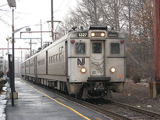
The Gladstone Branch is a branch of New Jersey Transit's Morris and Essex Lines. The Gladstone Branch primarily serves commuter trains; freight service is no longer operated. Out of 24 inbound and 24 outbound daily weekday trains, 2 peak-hour inbound and 2 peak-hour outbound trains use the Kearny Connection to New York Penn Station, all bypassing Secaucus Junction. The rest go to Hoboken Terminal. The part of the line west of Summit is single-tracked with passing sidings at Murray Hill, Stirling, and west of Far Hills and operates in peak-direction only on weekday peak hours, except for some service operating reverse-peak from Murray Hill in the PM peak. Bernardsville also has a passing siding, but is no longer used, as the Far Hills one is currently in use. On weekends the line operates Gladstone-Summit service hourly along the branch. The line is colored pale green on system maps and its symbol is a horse.

The Morristown Line is one of New Jersey Transit's commuter rail lines and is one of two branches that run along the Morris and Essex Lines. Out of 60 inbound and 58 outbound daily weekday trains, 28 inbound and 26 outbound Midtown Direct trains use the Kearny Connection to Secaucus Junction and New York Penn Station; the rest go to Hoboken Terminal. Passengers can transfer at Newark Broad Street or Summit to reach the other destination. On rail system maps the line is colored dark green, and its symbol is a drum.

For the purposes of this article, the Jersey City area extends North to Edgewater, South to Bayonne and includes Kearny Junction and Harrison but not Newark. Many routes east of Newark are listed here.
The Northern Branch is a railroad line that runs from Jersey City to Northvale in northeastern New Jersey. The line was constructed in 1859 by the Northern Railroad of New Jersey to connect the New York and Erie Rail Road's Piermont Branch terminus in Piermont, New York, to Erie's Pavonia Terminal in Jersey City. The line was then extended to Nyack, New York, in 1870 and provided passenger service until 1966. Ownership of the line passed into the hands of Conrail upon the latter's formation in 1976.

Mt. Pleasant is a neighborhood in Newark in Essex County, New Jersey, United States. It is east of Branch Brook Park and north of the Lower Broadway neighborhood. It is named for the hill overlooking the Passaic River on which it rests.
The Morris and Essex Railroad was a railroad across northern New Jersey, later part of the main line of the Delaware, Lackawanna and Western Railroad.

Riverside is a larger neighborhood in Paterson, New Jersey and, as its name states, this neighborhood is bound by the Passaic River to the west, north and east, separating the city from Hawthorne and offering 5 major crossings into the Greater Paterson Borough of Fair Lawn, giving residents access to NJ Transits Urban Local-Hoboken PATH Connect Train Line in the Radburn and Broadway Districts, easily accessible by Bus, car, or walking, as well as keeping Jewish, Muslim, Baptist, Eastern Orthodox, etc. Religious Communities and families within walking distance of relatives, places of Worship, and other points of interests within the East Rivers 07514-07410 neighborhoods. It is loosely bounded in the south by 10th Avenue and Montgomery Street from the Eastside neighborhood, but it is common for anyone who lived, lives, or frequents the area the boundary using the word "Riversude" begins, from South to North, at Broadway to 1st/Maple Ave. and, from West to East, from Madison Ave to River Rd, to call their neighborhood "Riverside" within the sub-Culture of the 07514-07410 East River area, typically referred to as "River Rats", named after the 2 ft Long Rats that can be seen swimming, flipping or basking in the Sun in and around the East River. Riverside is mostly a quiet working-class neighborhood. The neighborhood is mostly residential with some industrial uses. Madison Avenue cuts through the heart of this district, but to many this is a loose boundary with Madison Ave. being the Western boundary, while Route 20 runs through the eastern border of Riverside providing an easy commute to Route 80 East and New York City. However, traditionally "Riverside" ended at River Rd. This section is ethnically diverse with a growing Hispanic community concentrating mostly north and along River Street. African Americans and Caribbean blacks live south of River Street. Many Albanians make their home in the East 18th Street and River Street areas. River View Terrace is located in this neighborhood. Riverside is located in parts of the 3rd and 4th Wards of Paterson.

Kingsland is a railroad station on New Jersey Transit's Main Line. It is located under Ridge Road (Route 17) between New York and Valley Brook Avenues in Lyndhurst, New Jersey, and is one of two stations in Lyndhurst. The station is not staffed, and passengers use ticket vending machines (TVMs) located at street level to purchase tickets. The station is not handicapped-accessible. Originally part of the Delaware, Lackawanna and Western Railroad's Boonton Branch, Kingsland station was built in 1903.

Paterson is a New Jersey Transit commuter rail train station located on an elevated viaduct above Market Street in downtown Paterson, New Jersey. The railway through the station is double tracked, for north and south traffic on the NJT Main Line.
Woodside was a township that existed in Essex County, New Jersey, United States, from 1869 to 1871. Woodside was incorporated as a township by an Act of the New Jersey Legislature on March 24, 1869, from portions of Belleville Township On April 5, 1871, almost two weeks after its second anniversary, the township was dissolved, and its territory was absorbed by Belleville and Newark. Woodside Station, which today would be at the intersection of Grafton Ave & Oraton St was a stop on the Erie Lackawanna Railroad Newark Branch. Passenger service was discontinued in 1966, although the freight line is still used to service several local industries, operated by Norfolk Southern Railroad Corp. Today, Woodside is Newark's northeasternmost neighborhood.
The New York and Greenwood Lake Railway owned a line between Croxton, Jersey City, New Jersey and Greenwood Lake, New York. Service on the line was provided by the Erie Railroad.

The Montclair-Boonton Line is a commuter rail line of New Jersey Transit Rail Operations in the United States. It is part of the Hoboken Division. The line is a consolidation of three individual lines: the former Delaware, Lackawanna & Western Railroad's Montclair Branch, which ran from Hoboken Terminal to Bay Street, Montclair; the Erie Railroad's Greenwood Lake Division, which originally ran from the Erie's Jersey City Terminal to Greenwood Lake, NY; and the former Lackawanna Boonton Line, which ran from Hoboken to Hackettstown, New Jersey. The Montclair-Boonton line was formed when the Montclair Connection opened on September 30, 2002. The line serves 28 active rail stations in New Jersey along with New York Pennsylvania Station. It crosses through six counties, serving six stations in the township of Montclair, two in the town of Bloomfield, and one in the city of Newark. Trains along the Montclair-Boonton Line heading eastward usually originate at Hackettstown, Mount Olive, Lake Hopatcong, Dover, or Montclair State University, bound for either Hoboken Terminal or New York Penn Station. On system maps the line is colored light red and its symbol is a bird.

Carlton Hill station was a former railroad station for the Erie Railroad in East Rutherford, New Jersey, United States. Carlton Hill station was the second station along the Erie's main line and the first station after Rutherford Junction, where the Erie's main line forked from the Bergen County Railroad. The station provided service for passengers in Rutherford and Wallington"s Carlton Hill district and freight billing for the Royce Chemical Company, producer of Royox household cleaner, epoxies and dyes.

Passaic Park station was a former railroad station for the Erie Railroad's main line in Passaic, New Jersey in the epomonyous section of the city. The station was located between the Carlton Hill station and the Prospect Street station. The station was the easternmost of four Erie stations that served the city of Passaic, being demolished in 1963 as part of the abandonment of the railroad line through Passaic and Clifton. Passaic Park station, originally opened as part of the Paterson and Ramapo Railroad, was reconstructed in 1888 as a 57-by-16-foot wooden structure. The wooden station was the common design for station depots used by the Erie Railroad, designated Type IV. The station was replaced in 1923 with a Spanish tile roof station made of concrete and stone, after six years of litigation between the railroad and the city of Passaic.

Passaic station was a railroad station for the Erie Railroad in downtown Passaic, New Jersey. The station sat in the center of Main Street at the corner of Madison Street. Though there were three other stations in the city — Prospect Street-Passaic and Passaic Park to the east, and Harrison Street to the west — the simply named Passaic station was the primary station for the city, located at grade in the busiest section of its main business street.

The NX Draw is an out-of-service railroad bridge on the Passaic River between Newark and Kearny, New Jersey. It is the 13th bridge from the river's mouth at Newark Bay and is 6.5 miles (10.5 km) upstream from it. The bascule bridge, built by the Erie Railroad and once part of its Newark Branch, has been abandoned in the raised position.

WR Draw is an out-of-service railroad bridge crossing the Passaic River between Newark and the Arlington section of Kearny, New Jersey. The plate girder rim-bearing swing bridge, originally built in 1897 and modified in 1911 and 1950, is the 14th bridge from the river's mouth at Newark Bay and is 8.1 miles (13.0 km) upstream from it. Last used for regular passenger service in 2002, it is welded in closed position as its height is not considered a hazard to navigation.

The Lyndhurst Draw is a railroad bridge crossing the Passaic River between Clifton and Lyndhurst in northeastern New Jersey. Built in 1903, it is owned and operated by New Jersey Transit Rail Operations (NJT).


