The National Road was the first major improved highway in the United States built by the federal government. Built between 1811 and 1837, the 620-mile (1,000 km) road connected the Potomac and Ohio Rivers and was a main transport path to the West for thousands of settlers. When improved in the 1830s, it became the second U.S. road surfaced with the macadam process pioneered by Scotsman John Loudon McAdam.

The Pennsylvania Turnpike is a toll highway that is operated by the Pennsylvania Turnpike Commission (PTC) in the Commonwealth of Pennsylvania in the United States. A controlled-access highway, it runs for 360 miles (580 km) across the state, connecting the Pittsburgh, Harrisburg and Philadelphia areas. It also passes through four tunnels as it crosses the Appalachian Mountains in central Pennsylvania.
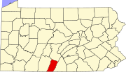
Fulton County is a county in the Commonwealth of Pennsylvania. As of the 2020 census, the population was 14,556, making it the fourth-least populous county in Pennsylvania. Its county seat is McConnellsburg. The county was created on April 19, 1850, from a part of Bedford County and named after inventor Robert Fulton.

Franklin County is a county in the Commonwealth of Pennsylvania. As of the 2020 census, the population was 155,932. Its county seat is Chambersburg.

Metal Township is a township that is located in Franklin County, Pennsylvania, United States. The population was 1,768 at the time of the 2020 census.
Shippensburg is a borough in Cumberland and Franklin counties in the U.S. Commonwealth of Pennsylvania. Settled in 1730, Shippensburg lies in the Cumberland Valley, 41 miles (66 km) southwest of Harrisburg, and is part of the Harrisburg–Carlisle Metropolitan Statistical Area. The population was 5,478 at the 2020 census.

The Tuscarora Trail is a 252-mile (406 km) hiking trail in the eastern United States, following the Appalachian Mountains through portions of Virginia, West Virginia, Maryland, and Pennsylvania. Its route is roughly parallel to, and to the west of, the Appalachian Trail.

Sideling Hill, also Side Long Hill, is a long, steep, narrow mountain ridge in the Ridge-and-Valley physiographic province of the Appalachian Mountains, located in Washington County in western Maryland and adjacent West Virginia and Pennsylvania, USA. The highest point on the ridge is Fisher Point, at 2,310 feet (700 m) in Fulton County, Pennsylvania.

Sideling Hill Tunnel is one of three original Pennsylvania Turnpike tunnels abandoned after two massive realignment projects. The others are nearby Rays Hill Tunnel, and farther west, the Laurel Hill Tunnel. It was less expensive to realign the Turnpike than to bore a second tube for four lane traffic. Sideling Hill Tunnel is 6,782 feet (2,067 m) long.

Shamokin was a multi-ethnic Native American trading village on the Susquehanna River, located partially within the limits of the modern cities of Sunbury and Shamokin Dam, Pennsylvania. It should not be confused with present-day Shamokin, Pennsylvania, located to the east. The village was the focus of missionary efforts, and then was the staging area for raids on English settlements in Pennsylvania during the French and Indian War. It was burned and abandoned by the Lenape in May, 1756. A few months later, Fort Augusta was constructed on the site of the village.

Aldie is an unincorporated community and census-designated place (CDP) located between Chantilly and Middleburg in Loudoun County, Virginia, United States. The historic village of Aldie is located on the John Mosby Highway in a gap between the Catoctin Mountains and Bull Run Mountains, through which the Little River flows. Aldie traditionally serves as the gateway to the Loudoun Valley and beyond.
Tuscarora may refer to the following:

Buchanan's Birthplace State Park is an 18.5-acre (7.5 ha) Pennsylvania state park near Cove Gap in Peters Township, Franklin County, Pennsylvania. The park is on Pennsylvania Route 16 along Tuscarora Mountain. Buchanan's Birthplace State Park was created from land donated to the state by Harriet Lane in honor of her uncle, the 15th President of the United States, James Buchanan.

Cowans Gap State Park is a 1,085-acre (439 ha) Pennsylvania state park in Todd Township, Fulton County and Metal Township, Franklin County, Pennsylvania in the United States. The park is largely surrounded by Buchanan State Forest in Allens Valley just off Pennsylvania Route 75 near Fort Loudon.

Pennsylvania Route 75 is a 71.2-mile-long (114.6 km) north–south state highway located in central Pennsylvania. The southern terminus is at the Mason–Dixon line in Montgomery Township, where the road continues into Maryland as Maryland Route 494. The northern terminus is at an interchange with U.S. Route 22 and US 322 northeast of Port Royal. PA 75 is a two-lane undivided road that passes through the Ridge-and-Valley Appalachians in Franklin and Juniata counties. The route heads north from the Maryland border in Franklin County to Mercersburg, where it runs concurrent with PA 16 and PA 416. From Mercersburg, PA 75 heads north and crosses US 30 in Fort Loudon before it runs northeast through a long valley, where it has an interchange with the Pennsylvania Turnpike in Willow Hill. The route turns north and heads into Juniata County, where it continues through another valley. PA 75 passes through Port Royal and crosses the Juniata River before it comes to its terminus at US 22/US 322.

The Standing Stone Trail is an 84.2-mile (135.5 km) linear hiking trail in south-central Pennsylvania, leading from Cowans Gap State Park in Fulton County, north to Detweiler Run Natural Area in Huntingdon County. Most of the trail follows rocky ridgetops in the Appalachian Mountains, with some walking through agricultural valleys and small towns, and it also passes through various segments of Rothrock State Forest and four different State Game Lands. It was constructed to connect the Tuscarora Trail and Mid State Trail, and it is a component of the Great Eastern Trail network.
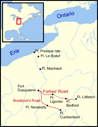
The Forbes Road, a historic military roadway in what was then British America, was initially completed in 1758 from Carlisle, Pennsylvania, to the French Fort Duquesne at the junction of the Allegheny and Monongahela rivers in what is now downtown Pittsburgh, via Fort Loudon, Fort Lyttleton, Fort Bedford and Fort Ligonier. The road, initially about 220 miles long, was named for Brigadier General John Forbes, the commander of the 1758 British-led expedition that built the road during the French and Indian War. The Forbes Road and Braddock's Road were the two main land routes that the British cut west through the wilderness during the war. The task was complicated by the Appalachian Mountains' steep northeast-to-southwest ridges, a generally broken terrain between the ridges, heavy forestation, and numerous swamps and rivers.

The Trapps Mountain Hamlet Historic District is located on the Shawangunk Ridge in Gardiner, New York, United States. It is a large area that covers the site of a settlement that thrived there from the late 18th to mid-20th centuries. Inhabitants practiced subsistence farming, making it one of the rare such communities in the East to have left any trace remaining. They supplemented that with a variety of other trades, primarily in the forest products industry, with most inhabitants gradually coming to work at nearby mountain resorts in the 20th century. The last resident died in 1956.

Brady's Bend Iron Company Furnaces is a set of historic blast furnaces and rolling mill located in Brady's Bend Township, Armstrong County, Pennsylvania. The furnaces are constructed of stone, with the first blown into production in 1840. A second furnace was added in 1845. They were hot blast furnaces powered by a 250-horsepower steam engine. The rolling mill was also powered by a 250-horsepower steam engine and went into production in January 1842. The furnaces and mill were established by the Great Western Iron Works in August 1839, and is considered by some the "Pittsburgh of the Middle 1800s" and "Cradle of the Iron and Steel Industry in America." It was known as the Brady's Bend Iron Company after 1844. The company was credited with manufacturing the first T-rails west of the Allegheny Mountains. The works closed in 1873.

Upper Strasburg is an unincorporated community that is located in Letterkenny Township in Franklin County, Pennsylvania, United States.