List of Native American archaeological sites on the National Register of Historic Places in Pennsylvania

Last updated

This is a list of Native American archaeological sites on the National Register of Historic Places in Pennsylvania.

Contents

Historic sites in the United States qualify to be listed on the National Register of Historic Places by passing one or more of four different criteria; Criterion D permits the inclusion of proven and potential archaeological sites. [1] Approximately one hundred different sites in Pennsylvania are listed under this criterion, including both Native American and European sites. [2] This list includes all properties in Pennsylvania that qualify under Criterion D due to the presence of Native American artifacts.

Map all coordinates using: OpenStreetMap

Sites

[3] Landmark nameImageLocationCountyCultureComments
1 Archeological Site 36 LY 37 [4] Canfield Island 2.jpg Loyalsock Township: coextensive with Canfield Island
41°14′32″N76°57′11″W / 41.24222°N 76.95306°W / 41.24222; -76.95306 (Archeological Site 36 LY 37)
Lycoming Multiple: Late Archaic through Susquehannock
2 Big and Little Indian Rock Petroglyphs [5] Conestoga Township: in the Susquehanna River, south of Safe Harbor
39°55′15″N76°23′5″W / 39.92083°N 76.38472°W / 39.92083; -76.38472 (Big and Little Indian Rock Petroglyphs)
Lancaster Unknown
3 Book site (36 Jul) [6] Book Site from the road.jpg Beale Township: off Legislative Route 3019
40°28′44.5″N77°30′2.4″W / 40.479028°N 77.500667°W / 40.479028; -77.500667 (Book site (36 Jul))
Juniata Clemson Island
4 Calver Island [7] Swatara Township: in the Susquehanna River, southeast of Harrisburg
40°12′20″N76°48′24″W / 40.20556°N 76.80667°W / 40.20556; -76.80667 (Calver Island)
Dauphin Multiple: Late Archaic through Early Woodland
5 Carbaugh Run Rhyolite Quarry Site (36AD30) [8] Franklin Township: atop Snaggy Ridge, west of Carbaugh Run
39°53′2.4″N77°27′26.4″W / 39.884000°N 77.457333°W / 39.884000; -77.457333 (Carbaugh Run Rhyolite Quarry Site (36AD30))
Adams Multiple: Late Archaic through Early Woodland
6 Clemson Island Prehistoric District [9] Halifax Township: southern portion of Clemson Island in the Susquehanna River
40°26′59″N76°56′41.5″W / 40.44972°N 76.944861°W / 40.44972; -76.944861 (Clemson Island Prehistoric District)
Dauphin Multiple: Early Archaic through Late Woodland Type site for the Clemson Island culture
7 Conestoga Town [10] Conestoga Town overview.jpg Manor Township: junction of Safe Harbor and Indian Marker Rds., near Letort
39°57′35.4″N76°24′1.4″W / 39.959833°N 76.400389°W / 39.959833; -76.400389 (Conestoga Town)
Lancaster Susquehannock
8 Deffenbaugh Site (36FA57) [11] Deffenbaugh Site.jpg Nicholson Township: on a saddle between two hills, along Old Frame Rd.
39°48′7.2″N79°51′36″W / 39.802000°N 79.86000°W / 39.802000; -79.86000 (Deffenbaugh Site (36FA57))
Fayette Monongahela
9 Duncan Island (36LA60,61) [12] Martic Township: in the Susquehanna River above Holtwood
39°51′41″N76°21′49″W / 39.86139°N 76.36361°W / 39.86139; -76.36361 (Duncan Island (36LA60,61))
Lancaster Archaic
10 Dykeman's Spring [13] Dykeman's Spring Hatch House and Pond.png Shippensburg: Dykeman Rd., 0.25 miles (0.40 km) east of Pennsylvania Route 696
40°2′33″N77°30′57″W / 40.04250°N 77.51583°W / 40.04250; -77.51583 (Dykeman's Spring)
Cumberland Multiple: Early Archaic through Woodland
11 Fisher Farm site [14] Fisher Farm Site.jpg Unionville: along U.S. Route 220, straddling a rail line
40°54′15.6″N77°52′40″W / 40.904333°N 77.87778°W / 40.904333; -77.87778 (Fisher Farm site)
Centre Late Woodland
12 Fisher Site (36GR21) [15] Fisher Site fields.jpg Richhill Township: off Camp Resort Rd. along the Enlow Fork
39°57′36″N80°28′0″W / 39.96000°N 80.46667°W / 39.96000; -80.46667 (Fisher Site (36GR21))
Greene Monongahela
13 Richard T. Foley Site (36GR52) [16] Richard T. Foley Site with buildings.jpg Jackson Township: along Job Creek
39°49′50.7″N80°22′54″W / 39.830750°N 80.38167°W / 39.830750; -80.38167 (Richard T. Foley Site (36GR52))
Greene Monongahela
14 Francis Farm Petroglyphs Site (36FA35) [17] [18] Perry Road toward ridgeline.jpg Jefferson Township: off Perry Road, 1 mile (1.6 km) west of the junction of Pennsylvania Routes 51 and 201
40°3′0″N79°47′30″W / 40.05000°N 79.79167°W / 40.05000; -79.79167 (Francis Farm Petroglyphs Site (36FA35))
Fayette Unknown
15 Frey-Haverstick Site (36LA6) [19] Frey-Haverstick Site.jpg Manor Township: eastern side of the Susquehanna River at Washington Boro, north of Staman's Run
39°59′42″N76°28′13.8″W / 39.99500°N 76.470500°W / 39.99500; -76.470500 (Frey-Haverstick Site (36LA6))
Lancaster Multiple: Late Archaic through Susquehannock
16 Household No. 1 Site (36WM61) [20] Household No. 1 Site, southern portion.jpg Rostraver Township: off Timms Ln.
40°10′27.7″N79°46′44.4″W / 40.174361°N 79.779000°W / 40.174361; -79.779000 (Household No. 1 Site (36WM61))
Westmoreland Monongahela
17 Houserville Site (36CE65) [21] Houserville Site overview from north.jpg College Township: 1300 block of E. College Ave., east of State College
40°48′42″N77°50′4″W / 40.81167°N 77.83444°W / 40.81167; -77.83444 (Houserville Site (36CE65))
Centre Early and Middle Archaic
18 Indian God Rock Petroglyphs Site (36VE26) [22] Indian God Rock.jpg Rockland Township: on the eastern bank of the Allegheny River above Brandon
41°19′48″N79°49′27″W / 41.33000°N 79.82417°W / 41.33000; -79.82417 (Indian God Rock Petroglyphs Site (36VE26))
Venango Unknown
19 Byrd Leibhart Site (36YO170) [23] Gravestones at Byrd Leibhart.jpg Lower Windsor Township: Native Lands County Park
39°58′41.4″N76°29′54″W / 39.978167°N 76.49833°W / 39.978167; -76.49833 (Leibhart, Byrd, Site (36YO170))
York Susquehannock
20 Oscar Leibhart Site (36YO9) [24] Lower Windsor Township: along the Susquehanna River, north of Klines Run
39°59′20.4″N76°30′1″W / 39.989000°N 76.50028°W / 39.989000; -76.50028 (Leibhart, Oscar, Site (36YO9))
York Susquehannock
21 Locus 7 Site [25] Locus 7 Site.jpg Washington Township: on a bluff above Downers Run north of Fayette City, 2,000 feet (610 m) east of the Monongahela River
40°6′24″N79°50′13″W / 40.10667°N 79.83694°W / 40.10667; -79.83694 (Locus 7 Site)
Fayette Monongahela
22 Meadowcroft Rockshelter [26] MeadowcroftRockshelter.jpg Independence Township: west of Avella
40°17′11″N80°29′30″W / 40.28639°N 80.49167°W / 40.28639; -80.49167 (Meadowcroft Rockshelter)
Washington Multiple: Paleoindian through Late Woodland
23 Memorial Park Site [27] Memorial Park Site in Lock Haven, Pennsylvania.jpg Lock Haven: on the southern bank of the Susquehanna River near the confluence of Bald Eagle Creek
41°8′19.2″N77°25′4.3″W / 41.138667°N 77.417861°W / 41.138667; -77.417861 (Memorial Park Site)
Clinton Clemson Island
24 Minisink Archeological Site [28] Manna site cut bank 1.jpg Dingman Township: in the vicinity of Minisink Island
41°17′26.2″N74°49′44.4″W / 41.290611°N 74.829000°W / 41.290611; -74.829000 (Minisink Archeological Site)
Pike Multiple: Early Archaic through Shawnee
25 Murry Site [29] Murry Site fields.jpg Manor Township: 2 miles south of Washington Boro
39°58′44.4″N76°27′10.8″W / 39.979000°N 76.453000°W / 39.979000; -76.453000 (Murry Site)
Lancaster Susquehannock
26 North Warwick Historic and Archeological District [30] Crow's Nest Visitor Center.JPG Warwick Township: Pennsylvania Route 345 and Harmonyville, Bethesda, Hopewell, Piersol, Trythall, and Northside Rds.
40°11′18″N75°46′8″W / 40.18833°N 75.76889°W / 40.18833; -75.76889 (North Warwick Historic and Archeological District)
Chester Multiple: Late Archaic through Late Woodland
27 Park Site 36La96 [31] Lcaster PA C Park ballfields.jpg Lancaster: on a knoll in Central Park, midway between the Conestoga River and Mill Creek
40°1′7″N76°17′3.7″W / 40.01861°N 76.284361°W / 40.01861; -76.284361 (Park Site 36La96)
Lancaster Susquehannock
28 Roberts Farm Site (36LA1) [32] Manor Township: on a knoll above the Conestoga River, just above its confluence with the Susquehanna River, near Conestoga
39°56′42.4″N76°22′26.8″W / 39.945111°N 76.374111°W / 39.945111; -76.374111 (Roberts Farm Site (36LA1))
Lancaster Multiple: Late Archaic through Susquehannock
29 Shawnee-Minisink Site [33] SHAWNEE MINISINK SITE, MONROE CTY, PA.jpg Smithfield Township: confluence of Brodhead Creek and the Delaware River
40°59′25″N75°8′2.7″W / 40.99028°N 75.134083°W / 40.99028; -75.134083 (Shawnee-Minisink Site)
Monroe Multiple: Paleoindian through Late Archaic
30 Shenks Ferry Site (36LA2) [34] Conestoga Township: along Grubbs Creek north of Pequea, ¾ mile above the Susquehanna River
39°54′18″N76°21′36.7″W / 39.90500°N 76.360194°W / 39.90500; -76.360194 (Shenks Ferry Site (36LA2))
Lancaster Multiple: Shenks Ferry through Susquehannock Type site for the Shenks Ferry culture
31 Shoop Site (36DA20) [35] Jackson Township: east of Enders
40°29′14″N76°49′12″W / 40.48722°N 76.82000°W / 40.48722; -76.82000 (Shoop Site (36DA20))
Dauphin Paleoindian
32 Shultz-Funk Site (36LA7 and 36LA9) [36] Shultz-Funk Site from west.jpg Manor Township: above the Susquehanna River near Washington Boro, immediately south of Witmer's Run
39°58′6.4″N76°27′17.9″W / 39.968444°N 76.454972°W / 39.968444; -76.454972 (Shultz-Funk Site (36LA7 and 36LA9))
Lancaster Late Woodland
33 Site 36BD90 [37] Reconstructed building in Old Bedford Village.jpg Bedford Township: on the grounds of Bedford Village
40°2′31.2″N78°30′38.4″W / 40.042000°N 78.510667°W / 40.042000; -78.510667 (Site 36BD90)
Bedford Monongahela
34 Sommerheim Park Archaeological District [38] Sommerheim Park Archaeological District Apr 13.jpg Millcreek Township: on bluffs above Sommerheim Dr. and Presque Isle Bay
42°6′49″N80°8′42″W / 42.11361°N 80.14500°W / 42.11361; -80.14500 (Sommerheim Park Archaeological District)
Erie Multiple: Early Archaic through Middle Woodland
35 Squirrel Hill Site [39] Squirrel Hill Site.jpg St. Clair Township: west of New Florence near the banks of the Conemaugh River
40°22′49″N79°5′20.3″W / 40.38028°N 79.088972°W / 40.38028; -79.088972 (Squirrel Hill Site)
Westmoreland Monongahela
36 Strickler Site [40] Strickler Site from River Road.jpg Manor Township: ¾ mile north of Creswell Station, and 1 mile south of Washington Boro
39°58′48″N76°27′40″W / 39.98000°N 76.46111°W / 39.98000; -76.46111 (Strickler Site)
Lancaster Susquehannock
37 Sugar Grove Petroglyph Site (36GR5) [18] [41] Sugar Grove Petroglyphs.jpg Monongahela Township: off Pennsylvania Route 88, 0.7 miles (1.1 km) northwest of its bridge over Whiteley Creek
39°49′36″N79°57′40″W / 39.82667°N 79.96111°W / 39.82667; -79.96111 (Sugar Grove Petroglyph Site (36GR5))
Greene Unknown
38 Tudek Site [42] Tudek Site.jpg College Township: along Orchard Rd., northeast of State College
40°49′1″N77°51′3″W / 40.81694°N 77.85083°W / 40.81694; -77.85083 (Tudek Site)
Centre Early and Middle Archaic

See also

Related Research Articles

<span class="mw-page-title-main">College Township, Centre County, Pennsylvania</span> Township in Pennsylvania, United States

College Township is a township in Centre County, Pennsylvania. It is part of the State College, Pennsylvania metropolitan statistical area. The population was 10,762 at the 2020 census, which was a 13% increase from the 2010 census. College Township was formed on November 25, 1875, from Howard Township.

<span class="mw-page-title-main">Houserville, Pennsylvania</span> Census-designated place in Pennsylvania, United States

Houserville is an unincorporated community and census-designated place (CDP) in Centre County, Pennsylvania, United States. It is part of the State College, Pennsylvania Metropolitan Statistical Area. The population was 1,814 at the 2010 census.

<span class="mw-page-title-main">Bald Eagle Creek (West Branch Susquehanna River tributary)</span>

Bald Eagle Creek is a 55.2-mile-long (88.8 km) tributary of the West Branch Susquehanna River mostly in Centre County, Pennsylvania, in the United States.

<span class="mw-page-title-main">Barnesville Petroglyph</span> Archaeological site in Ohio, United States

The Barnesville Petroglyph petroglyph site in the eastern part of the U.S. state of Ohio. Located approximately 3 miles (4.8 km) southwest of the village of Barnesville in Belmont County, the petroglyphs have been known both by archaeologists and the general public since the 1850s or earlier. Although the site was significantly damaged during the twentieth century, it is still a significant archaeological site, and has been named a historic site.

<span class="mw-page-title-main">Memorial Park Site</span> United States historic place

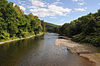
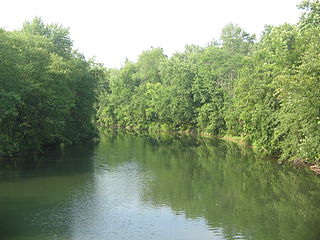
The Memorial Park Site is an archaeological site located near the confluence of Bald Eagle Creek and the West Branch Susquehanna River in Lock Haven in the U.S. state of Pennsylvania. Research projects conducted at the site since 1979 have found prehistoric cultural deposits that collectively span 8,000 years.

<span class="mw-page-title-main">Canfield Island Site</span> United States historic place

The Canfield Island Site, also known as Archeological Site 36LY37, is an archaeological site in Lycoming County, Pennsylvania, United States. Located on Canfield Island in the West Branch Susquehanna River, the site lies east of the city of Williamsport in Loyalsock Township. It is believed to have been inhabited by prehistoric Native Americans for thousands of years, with the oldest discoveries dating back to more than one millennium before Christ.

<span class="mw-page-title-main">Richard T. Foley Site</span> United States historic place

The Richard T. Foley Site is an archaeological site in Jackson Township, Greene County, Pennsylvania, United States, in the southwestern corner of the state. Located along Job Creek, the site was known since the late 1960s to local artifact collectors as a valuable collection location. Significant artifacts were discovered by landowner Richard T. Foley in 1971, when he began to plow part of the site to expand his garden. Having found bits of flint, bone, and pottery, Foley contacted local archaeologists, who soon began a three-year excavation of the property. A larger investigation was carried out by archaeologists from the Carnegie Museum of Natural History in 1982; they discovered that the area previously excavated was only the periphery of a larger campsite. Later in 1982, work led by James T. Herbstritt discovered a village site elsewhere on the property.

<span class="mw-page-title-main">Bedford Village Archeological Site</span> United States historic place

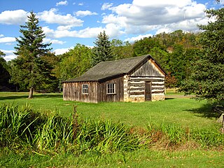
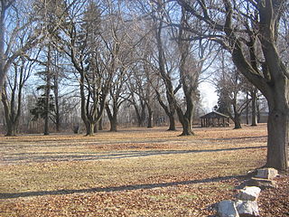
The Bedford Village Archeological Site (36BD90) is an archaeological site in central Bedford County, Pennsylvania, United States. Located in Bedford Township north of the borough of Bedford, it was once occupied by a Monongahela culture village. Today, the site is the location of Old Bedford Village, an open-air museum, containing a variety of historic structures transported to the site from the surrounding towns of Bedford, Everett, and Rainsburg.

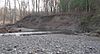
The Carbaugh Run Rhyolite Quarry Site is an archaeological site in Franklin Township, Adams County, Pennsylvania, United States. It is composed of two smaller sites: a group of small quarries on top of Snaggy Ridge, and the remnants of what may have been a campsite along Carbaugh Run below the ridge.

<span class="mw-page-title-main">Book site</span> Archaeological type site in Pennsylvania, United States of America

The Book site is an archaeological site in Juniata County, Pennsylvania, United States. Consisting of the remnants of a burial mound and a prehistoric village, the site lies on both sides of Camp Resort Road in Beale Township, near the community of Beale.

<span class="mw-page-title-main">Fisher Farm site</span> Archaeological type site in Pennsylvania, United States of America

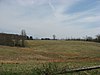
The Fisher Farm site is an archaeological site in Centre County, Pennsylvania, United States. Located in fields on the outskirts of Unionville, it is one of central Pennsylvania's leading archaeological sites.

<span class="mw-page-title-main">Houserville Site</span> United States historic place

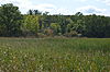
The Houserville Site is an archaeological site located near State College in Centre County, Pennsylvania, United States. Used as a stone workshop by prehistoric Native Americans ten thousand years ago, it has been recognized as a prime candidate for prehistoric preservation.

<span class="mw-page-title-main">Tudek Site</span> Native American archaeological site (stone quarry) in Pennsylvania

The Tudek Site is an archaeological site located near State College in Centre County, Pennsylvania, United States. Used as a stone quarry by prehistoric Native Americans ten thousand years ago, it has been recognized as a prime candidate for prehistoric preservation.

Shoop Site is a prehistoric archaeological site in Jackson Township and Wayne Township, Dauphin County, Pennsylvania. It is the site of a large Paleoindian campsite, dated to 9,000-9,500 BC. It was first discovered in the 1930s by George Gordon, and also studied by Frank Soday who later discovered the Quad site. In the decades since its discovery, the site has yielded approximately 7,000 artifacts scattered over at least 37 acres for lithic analysis. Additionally, there is a large number of “astoundingly reworked” fluted Projectile points and endscrapers, and fully 98% of the artifacts are made from a lithic material that originates hundreds of miles away.

<span class="mw-page-title-main">Clemson Island Prehistoric District</span> Historic district in Pennsylvania, United States

Clemson Island Prehistoric District is a historic archaeological site and national historic district located at Halifax Township, Dauphin County, Pennsylvania. It is a series of three spatially discrete loci. They constitute a transitional Middle Woodland - Late Woodland earthwork mound and associated village. There is evidence of occupation from the Early Archaic period to the 18th century. The mound was excavated in May and June 1929.

<span class="mw-page-title-main">Byrd Leibhart Site</span> United States historic place

The Byrd Leibhart Site, designated 36 YO 170 is a historic archaeological site located in Native Lands County Park at Lower Windsor Township, York County, Pennsylvania. It was the site of a late 17th-century fortified settlement. Artifacts were first discovered in 1929, and an excavation undertaken by the Pennsylvania Historical and Museum Commission took place in July–August 1970. The excavation identified three cemeteries, a village component, stockade, and a longhouse. The excavations uncovered a range of native and European trade goods dating to the late 17th century.

Shenks Ferry Site (36LA2) is a historic archaeological site located above Grubb Creek at Martic Township in Lancaster County, Pennsylvania. It underwent excavation in 1930-1931 and in 1973 by the Pennsylvania Historic and Museum Commission. The excavations identified the presence of a village and seasonal campsites dated to the Late Woodland period.

<span class="mw-page-title-main">Murry Site</span> United States historic place

The Murry Site is a prehistoric archaeological site located in Manor Township, Lancaster County, Pennsylvania. It is the site of a large, stockaded Shenks Ferry village. It was excavated in 1967, and identified as having been inhabited for 10 years, sometime between 1450 and 1550. They identified 46 burials.

<span class="mw-page-title-main">Shultz-Funk Site</span> United States historic place

The Shultz-Funk Site is a prehistoric archaeological site that is located in Manor Township, Lancaster County, Pennsylvania.

References

  1. National Register of Historic Places Fact Sheet, Pennsylvania Historical and Museum Commission. Accessed 2010-02-19.
  2. "National Register Information System". National Register of Historic Places . National Park Service. March 13, 2009.
  3. Numbers represent an ordering by significant words.
  4. Stevenson, Christopher M., and Conran A. Hay. National Register of Historic Places Inventory/Nomination: Archeological Site 36 LY 37. National Park Service, 1981-01-20.
  5. Kent, Barry C., and Susan M. Zacher. National Register of Historic Places Inventory/Nomination: Big and Little Indian Rock Petroglyphs. National Park Service, 1976-11-08.
  6. Beckerman, Ira C. National Register of Historic Places Inventory—Nomination Form: Book Site (36 Jul). National Park Service, 1980-08-08.
  7. Miller, Patricia. National Register of Historic Places Inventory/Nomination: Calver Island. National Park Service, 2006-06-27.
  8. Beckerman, Ira. National Register of Historic Places Inventory/Nomination: Carbaugh Run Rhyolite Quarry Site (36AD30). National Park Service, 1981.
  9. Beckerman, Ira C. National Register of Historic Places Inventory/Nomination: Clemson Island Prehistoric District. National Park Service, n.d.
  10. Smith, Ira F., III, and Barry C. Kent. National Register of Historic Places Inventory/Nomination: Conestoga Town. National Park Service, 1972-10-31.
  11. George, Richard L. National Register of Historic Places Inventory/Nomination: Deffenbaugh Site (36FA57). National Park Service, 1981-07-31.
  12. Kinsey, W. Fred. National Register of Historic Places Inventory/Nomination: Duncan Island (36LA60,61). National Park Service, July 1982.
  13. Parshall, Earl. National Register of Historic Places Inventory/Nomination: Dykeman's Spring. National Park Service, 1998-11-28. Accessed 2010-02-17.
  14. Stevenson, Christopher M., and Conran Hay. National Register of Historic Places Inventory/Nomination: Fisher Farm Site. National Park Service, 1980-06-05.
  15. Michael, Ronald L. National Register of Historic Places Inventory/Nomination: Fisher Site (36GR21). National Park Service, 1981-01-15.
  16. Herbstritt, James T. National Register of Historic Places Inventory/Nomination: Richard T. Foley Site (36GR52). National Park Service, 1982-11-05.
  17. Herbstritt, James T. National Register of Historic Places Inventory/Nomination: Francis Farm Petroglyphs Site. National Park Service, 1980-07-22.
  18. 1 2 Swauger, James L. Rock Art of the Upper Ohio Valley. Graz: Akademische Druck- und Verlagsanstalt, 1974, 115.
  19. Beckerman, Ira C. National Register of Historic Places Inventory/Nomination: Frey-Haverstick Site (36LA6). National Park Service, 1980.
  20. George, Richard L. National Register of Historic Places Inventory/Nomination: Household No. 1 Site (36WM61). National Park Service, 1981-04-30.
  21. Stevenson, Christopher M., and Conran Hay. National Register of Historic Places Inventory/Nomination: Houserville Site (36CE65). National Park Service, 1980-10-15.
  22. Cowin, Verna L. National Register of Historic Places Inventory/Nomination: Indian God Rock Petroglyphs Site (36VE26). National Park Service, 1982-04-15.
  23. Native Americans to Celebrate Saving Susquehannock Village Sites [ permanent dead link ], Susquehanna Greenway Heritage Area, 2009. Accessed 2010-02-17.
  24. Beckerman, Ira C. National Register of Historic Places Inventory/Nomination: Oscar Leibhart Site (36YO9). National Park Service, n.d.
  25. Michael, Ronald L. National Register of Historic Places Inventory/Nomination: Locus 7 Site. National Park Service, 1979-07-16.
  26. Tuttle, Donald L. National Register of Historic Places Inventory/Nomination: Meadowcroft Rockshelter. National Park Service, n.d. Accessed 2010-02-17.
  27. Stevenson, Christopher M., and Conran A. Hay. National Register of Historic Places Inventory/Nomination: Memorial Park Site. National Park Service, 1981-09-01.
  28. National Register of Historic Places Inventory/Nomination: Minisink Archeological Site. National Park Service, n.d.
  29. Beckerman, Ira C. National Register of Historic Places Inventory/Nomination: Murry Site. National Park Service, n.d.
  30. Cremers, Estelle. National Register of Historic Places Inventory/Nomination: North Warwick Historic and Archeological District. National Park Service, 1994-05-10.
  31. Kinsey, W. Fred. National Register of Historic Places Inventory/Nomination: Park Site 36La96. National Park Service, July 1982.
  32. Beckerman, Ira C. National Register of Historic Places Inventory/Nomination: Roberts Farm Site (36LA1). National Park Service, 1986.
  33. Shawnee Minisink Site Archived 2006-09-13 at the Wayback Machine , American University Department of Anthropology, n.d. Accessed 2010-02-17.
  34. Beckerman, Ira C. National Register of Historic Places Inventory/Nomination: Shenks Ferry Site (36LA2). National Park Service, n.d.
  35. Beckerman, Ira C. National Register of Historic Places Inventory/Nomination: Shoop Site (36DA20). National Park Service, 1980.
  36. Beckerman, Ira C. National Register of Historic Places Inventory/Nomination: Shultz-Funk Site (36LA7 and 36LA9). National Park Service, 1980-09-04.
  37. Beckerman, Ira. National Register of Historic Places Inventory/Nomination: Site 36BD90. National Park Service, n.d.
  38. Johnson, William C. National Register of Historic Places Inventory/Nomination: Sommerheim Park Archaeological District. National Park Service, 1981-06-29.
  39. Dragoo, Don W. National Register of Historic Places Inventory/Nomination: Squirrel Hill Site. National Park Service, 1977-04-19.
  40. Smith, Ira F., III. National Register of Historic Places Inventory/Nomination: Strickler Site. National Park Service, 1972-10-31.
  41. Herbstritt, James T. National Register of Historic Places Inventory/Nomination: Sugar Grove Petroglyph Site (36GR5). National Park Service, 1980-07-22.
  42. Stevenson, Christopher M., and Conran Hay. National Register of Historic Places Inventory/Nomination: Tudek Site. National Park Service, 1980-10-10.