Dingman Township, Pike County, Pennsylvania

Last updated

Dingman Township
Raymondskill Falls.jpg
Raymondskill Falls, Dingman Township, Pike County, within the Delaware Water Gap National Recreation Area.
Pike County Pennsylvania incorporated and unincorporated areas Dingman township highlighted.svg
Location in Pike County and the state of Pennsylvania.
Pennsylvania in United States (US48).svg
Location of Pennsylvania in the United States
Coordinates: 41°22′36″N74°57′59″W / 41.37667°N 74.96639°W / 41.37667; -74.96639
CountryUnited States
StatePennsylvania
County Pike
Area
[1]
  Total60.05 sq mi (155.53 km2)
  Land58.19 sq mi (150.71 km2)
  Water1.86 sq mi (4.82 km2)
Elevation
1,342 ft (409 m)
Population
 (2020) [2]
  Total12,487 Decrease2.svg
  Density214.64/sq mi (82.87/km2)
Time zone UTC-5 (EST)
  Summer (DST) UTC-4 (EDT)
Area code 570
FIPS code 42-103-19272
Website www.dingmantownship.org

Dingman Township is a township in Pike County, Pennsylvania, United States. The population was 12,487 at the 2020 census, [2] up from 11,926 in 2010. The Township was named in honor of Judge Daniel Westbrook Dingman, and was created on April 17, 1832 [3] from part of the former Upper Smithfield township. [4] [5]

Contents

History

The Callahan House, Minisink Archeological Site, and Gifford Pinchot House are listed on the National Register of Historic Places. [6]

Geography

According to the United States Census Bureau, the township has a total area of 59.9 square miles (155 km2), of which 58.2 square miles (151 km2) is land and 1 square mile (2.6 km2) (2.92%) is water.

Demographics

Historical population
CensusPop.Note
2000 8,788
2010 11,92635.7%
2020 12,8477.7%
2021 (est.)12,819 [2] −0.2%
U.S. Decennial Census [7]

As of the census [8] of 2010, there were 11,926 people, 4,185 households, and 3,304 families residing in the township. The population density was 204.9 inhabitants per square mile (79.1/km2). There were 5,346 housing units at an average density of 91.9/sq mi. The racial makeup of the township was 91.7% White, 3.4% African American, 0.3% Native American, 0.8% Asian, 0.1% Native Hawaiian or Pacific Islander, 1.6% from other races, and 2% from two or more races. Hispanic or Latino of any race were 8.8% of the population.

There were 4,185 households, out of which 37.4% had children under the age of 18 living with them, 66.4% were married couples living together, 8.3% had a female householder with no husband present, and 21.1% were non-families. 16.7% of all households were made up of individuals, and 5.8% had someone living alone who was 65 years of age or older. The average household size was 2.85 and the average family size was 3.22.

In the township the population was spread out, with 26.9% under the age of 18, 61.7% from 18 to 64, and 11.4% who were 65 years of age or older. The median age was 41.1 years.

The median income for a household in the township was $54,866, and the median income for a family was $56,458. Males had a median income of $41,589 versus $26,643 for females. The per capita income for the township was $21,519. About 4.1% of families and 4.2% of the population were below the poverty line, including 5.5% of those under age 18 and 5.9% of those age 65 or over.

Census-designated places

For statistical purposes, the U.S. Census Bureau designates four communities within Dingman Township as CDPs: Conashaugh Lakes, Gold Key Lake, Pocono Woodland Lakes and Sunrise Lake.

Related Research Articles

<span class="mw-page-title-main">Wayne County, Pennsylvania</span> County in Pennsylvania

Wayne is a county in the Commonwealth of Pennsylvania. The county's population was 51,155 at the 2020 census. The county seat is the Borough of Honesdale. The county was formed from part of Northampton County on March 21, 1798, and was named for the Revolutionary War General Anthony Wayne. The county is part of the Northeast Pennsylvania region of the state.

<span class="mw-page-title-main">Pike County, Pennsylvania</span> County in Pennsylvania, United States

Pike County is a county in the Commonwealth of Pennsylvania. As of the 2020 census, the population was 58,535. Its county seat is Milford. The county is part of the Northeast Pennsylvania region of the state.

Cheshire Township is a civil township of Allegan County in the U.S. state of Michigan. The population was 2,211 at the 2020 census.

<span class="mw-page-title-main">Pike Bay Township, Cass County, Minnesota</span> Township in Minnesota, United States

Pike Bay Township is a township in Cass County, Minnesota, United States. The population was 1,643 as of the 2000 census. Pike Bay Township was named for Pike Bay of Cass Lake, and indirectly for Zebulon Pike, an explorer.

<span class="mw-page-title-main">Pike Township, Berks County, Pennsylvania</span> Township in Pennsylvania, United States

Pike Township is a township in Berks County, Pennsylvania, United States. The population was 1,723 at the 2010 census.

<span class="mw-page-title-main">Herrick Township, Bradford County, Pennsylvania</span> Township in Pennsylvania, United States

Herrick Township is a township in Bradford County, Pennsylvania, United States. It is part of Northeastern Pennsylvania. The population was 754 at the 2010 census. For years it was known for a chair sitting on a fence post as you entered the town from the south on route 1017.

<span class="mw-page-title-main">Pike Township, Bradford County, Pennsylvania</span> Township in Pennsylvania, United States

Pike Township is a township in Bradford County, Pennsylvania, United States. It is part of Northeastern Pennsylvania. The population was 671 at the 2010 census.

<span class="mw-page-title-main">Lumber City, Pennsylvania</span> Former Borough in Pennsylvania, United States

Lumber City is a former borough in Clearfield County, Pennsylvania, United States. The population was 76 at the 2010 census.

<span class="mw-page-title-main">Silver Spring Township, Pennsylvania</span> Township in Pennsylvania, United States

Silver Spring Township is a township in Cumberland County, Pennsylvania, United States. The population was 13,657 at the 2010 census, up from 10,592 at the 2000 census.

<span class="mw-page-title-main">Wayne Township, Erie County, Pennsylvania</span> Township in Pennsylvania, United States

Wayne Township is a township in Erie County, Pennsylvania, United States. The population was 1,539 at the 2020 census, down from 1,659 at the 2010 census, down from 1,766 in 2000.

<span class="mw-page-title-main">Smithfield Township, Monroe County, Pennsylvania</span> Place in Pennsylvania, United States

Smithfield Township is a township in Monroe County, Pennsylvania, United States. The population was 8,001 at the 2020 census.

<span class="mw-page-title-main">Delaware Township, Pike County, Pennsylvania</span> Township in Pennsylvania, United States

Delaware Township is a township in Pike County, Pennsylvania, United States. The population was 7,453 at the 2020 census. The Birchwood Lakes housing community is located in Delaware Township.

<span class="mw-page-title-main">Palmyra Township, Pike County, Pennsylvania</span> Township in Pennsylvania, United States

Palmyra Township is a township in Pike County, Pennsylvania. The population was 3,312 at the 2010 census. The majority of its northwestern border is Lake Wallenpaupack.

<span class="mw-page-title-main">Wayne Township, Schuylkill County, Pennsylvania</span> Township in Pennsylvania, United States

Wayne Township is a township in Schuylkill County, Pennsylvania, United States. The population was 5,226 at the 2020 census. The township includes the village of Reedsville which contains a medium size state police barracks. Children from this township attend schools in the Blue Mountain School District. The township is divided by north-to-south PA Route 183 which serves as a highway connecting Schuylkill and Berks Counties. The Schuylkill County Fairgrounds are located in the township off east-to-west PA Route 895. 183 and 895 meet in the Census Designated Place of Summit Station.

<span class="mw-page-title-main">Clymer Township, Tioga County, Pennsylvania</span> Township in Pennsylvania, United States

Clymer Township is a township in Tioga County, Pennsylvania, United States. The population was 621 at the 2020 census.

<span class="mw-page-title-main">Berlin Township, Wayne County, Pennsylvania</span> Second-class township in Pennsylvania, United States

Berlin Township is a second-class township in Wayne County, Pennsylvania, United States. The township's population was 2,452 at the time of the 2020 United States Census.

<span class="mw-page-title-main">Lake Township, Wayne County, Pennsylvania</span> Second-class township in Pennsylvania, United States

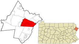
Lake is a second-class township in Wayne County, Pennsylvania, United States. The township's population was 5,269 at the time of the 2010 United States Census.

<span class="mw-page-title-main">Palmyra Township, Wayne County, Pennsylvania</span> Township in Pennsylvania, United States

Palmyra is a second-class township in Wayne County, Pennsylvania. The township's population was 1,339 at the time of the 2010 United States Census.

<span class="mw-page-title-main">Paupack Township, Pennsylvania</span> Township in Pennsylvania, United States

Paupack is a second-class township in Wayne County, Pennsylvania, United States. The township's population was 3,828 at the time of the 2010 United States Census.

<span class="mw-page-title-main">Covington Township, Lackawanna County, Pennsylvania</span> Place in Pennsylvania, United States

Covington Township is a township in Lackawanna County, Pennsylvania, United States. The population was 2,206 as of the 2020 Census.

References

  1. "2016 U.S. Gazetteer Files". United States Census Bureau. Retrieved August 14, 2017.
  2. 1 2 3 Bureau, US Census. "City and Town Population Totals: 2020—2021". Census.gov. US Census Bureau. Retrieved August 6, 2022.
  3. "History of Wayne, Pike, and Monroe Counties, Pennsylvania". p. 905. Retrieved June 22, 2018.
  4. "History of Wayne, Pike, and Monroe Counties, Pennsylvania". p. 830. Retrieved June 22, 2018.
  5. "A map of Wayne & Pike counties, Pennsylvania : shewing the situations & forms of the warrantee tracts, with the numbers by which the respective tracts are distinguished in the maps & books in the Office of the Commissioners of places for Wayne County, the townships, boundaries, roads, waters and principal places". Library of Congress .
  6. "National Register Information System". National Register of Historic Places . National Park Service. July 9, 2010.
  7. "Census of Population and Housing". Census.gov. Retrieved June 4, 2016.
  8. "U.S. Census website". United States Census Bureau . Retrieved May 14, 2011.