
Lumberland is a town in Sullivan County, New York, United States. The population was 2,468 at the 2010 census.

The National Register of Historic Places in the United States is a register including buildings, sites, structures, districts, and objects. The Register automatically includes all National Historic Landmarks as well as all historic areas administered by the U.S. National Park Service. Since its introduction in 1966, more than 90,000 separate listings have been added to the register.

This is a list of properties and districts listed on the National Register of Historic Places in Pennsylvania. As of 2015, there are over 3,000 listed sites in Pennsylvania. Sixty-six of the 67 counties in Pennsylvania have listings on the National Register; Cameron County is the only county without any sites listed.
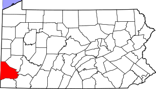
This is a list of the National Register of Historic Places listings in Washington County, Pennsylvania.
Aughwick Creek is a 30.8-mile-long (49.6 km) tributary of the Juniata River in Huntingdon County, Pennsylvania in the United States.

Concordville is an unincorporated community in Concord Township, Delaware County, Pennsylvania, United States. It is located 20 miles west-southwest of Philadelphia, at the junction of U.S. Routes 1 and 322. This intersection can be traced back to two of the earliest roads in Pennsylvania, Baltimore Pike which became U.S. 1, and Concord Pike, which connected Pennsylvania with Delaware.
Yellow Creek is a 20.9-mile-long (33.6 km) tributary of the Raystown Branch Juniata River in Bedford County, Pennsylvania, in the United States.
Dunning Creek is a 27.8-mile-long (44.7 km) tributary of the Raystown Branch Juniata River in south west/south central Pennsylvania in the United States.

Raven Rock is an unincorporated community and hamlet along the Delaware River approximately three miles (4.8 km) north of Stockton along New Jersey Route 29. The hamlet was known earlier as Saxtonville. It is located within Delaware Township in Hunterdon County, New Jersey, United States. It is the site of Bull's Island Recreation Area. The rock outcrop for which it is named is the southwest corner of the Hunterdon Plateau.
Point Pleasant is an unincorporated community in Tinicum and Plumstead Townships of Bucks County, Pennsylvania, United States. It lies on both sides of Tohickon Creek by the creek's confluence with the Delaware River; the creek is the dividing line between the townships. The ZIP code for the post office in Point Pleasant is 18950.

The Raystown Branch Juniata River is the largest and longest tributary of the Juniata River in south-central Pennsylvania in the United States.
Codorus Creek is a 42.4-mile-long (68.2 km) tributary of the Susquehanna River in York County, Pennsylvania in the United States.
Muddy Creek is a tributary of the Susquehanna River in York County, Pennsylvania, in the United States.
Sideling Hill Creek is a 21.9-mile-long (35.2 km) tributary of Aughwick Creek in Huntingdon County, Pennsylvania in the United States. Via Aughwick Creek and the Juniata River, it is part of the Susquehanna River watershed.

The Pond Eddy Bridge is a petit truss bridge spanning the Delaware River between the hamlet of Pond Eddy in Lumberland, New York and the settlement informally called Pond Eddy in Shohola Township, Pennsylvania. It is accessible from NY 97 in Lumberland on the New York side and two dead-end local roads, Flagstone Road and Rosa Road on the Pennsylvania side. The bridge was built in 1903 by the Oswego Bridge Company to replace an old suspension bridge that had washed away in a flood earlier in the year. It connected the bluestone quarries in Pennsylvania to New York.

This is a list of the National Register of Historic Places listings in Columbia County, Pennsylvania.

This is a list of the National Register of Historic Places listings in Pike County, Pennsylvania.
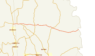
Pennsylvania Route 371 is a 23.5 mi (37.8 km) long state highway located in Susquehanna and Wayne Counties. The western terminus is at an intersection with Route 171 and Route 374 near the community of Union Dale in Herrick Center. The eastern terminus is at the New York state line in Damascus Township where it crosses the Delaware River on the Cochecton–Damascus Bridge. It continues into Sullivan County, New York, as County Route 114 (CR 114), which heads east toward New York State Route 97 (NY 97).

This is a list of the National Register of Historic Places listings in northern Westchester County, New York, excluding the city of Peekskill, which has its own list.

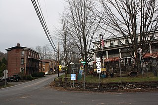
Pond Eddy is a hamlet in Sullivan County, New York, United States. The community is located along the Delaware River and New York State Route 97. The Pond Eddy Bridge links the hamlet to the community of Pond Eddy, Pennsylvania, which is only accessible via the bridge. Pond Eddy has a post office with ZIP code 12770.


