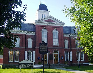
Pike County is a county in the Commonwealth of Pennsylvania. It is part of Northeastern Pennsylvania. As of the 2020 census, the population was 58,535. Its county seat is Milford.

Upper Saucon Township is a township in Lehigh County, Pennsylvania. It is part of the Lehigh Valley metropolitan area, which had a population of 861,899 and was the 68th-most populous metropolitan area in the U.S. as of the 2020 census. The township had a population of 16,973 as of the 2020 census.

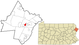
Dingman Township is a township in Pike County, Pennsylvania, United States. The population was 12,487 at the 2020 census, up from 11,926 in 2010. The Township was named in honor of Judge Daniel Westbrook Dingman, and was created on April 17, 1832 from part of the former Upper Smithfield township.

Matamoras is a borough in Pike County, Pennsylvania, United States. The population was 2,362 at the 2020 census. It is the easternmost municipality of any kind in Pennsylvania. Matamoras is part of the New York–Newark–Jersey City, NY–NJ–PA Metropolitan Statistical Area, as well as the larger New York–Newark, NY–NJ–CT–PA Combined Statistical Area.
Milford is a borough that is located in Pike County, Pennsylvania, United States, and the county seat. Its population was 1,103 at the time of the 2020 census.

The Dingmans Bridge is a toll bridge across the Delaware River between Delaware Township, Pennsylvania and Sandyston Township, New Jersey. Owned and operated by the Dingmans Choice and Delaware Bridge Company, it is the last privately-owned toll bridge on the Delaware and one of the few remaining in the United States. It is also the only bridge on the Delaware to toll traffic entering New Jersey.
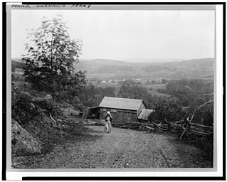
Dingmans Ferry is an unincorporated community in Delaware Township, Pike County, Pennsylvania, United States. As of 2014, it had a population of just over 1,000 people. It was originally sited on the Delaware River, in an area now included in the Delaware Water Gap National Recreation Area. When the Corps of Engineers acquired the land by eminent domain in the mid-twentieth century for the creation of the proposed Tocks Island Dam project, it relocated the community further up the hill.

Delaware Valley High School in Milford, Pennsylvania, United States, is a high school that serves grades 9–12 and is located in Pike County. As of 2019, it serves 1,517 students. The school is operated by the Delaware Valley School District.

County Route 560 is a county highway in the U.S. state of New Jersey. The highway extends 5.05 miles (8.13 km) from U.S. Route 206 and County Route 521 in Sandyston Township. CR 560 ends at the Pennsylvania state line, where it becomes Pike County Quadrant Route 2019, which connects to Pennsylvania Route 739. CR 560's entire length is in Sandyston. However, CR 560 does pass through the hamlet of Layton.

Pennsylvania Route 739 is a Pennsylvania highway contained entirely within Pike County, Pennsylvania. It was signed in 1967, and runs for 19 miles (31 km). Its northern terminus is at U.S. Route 6 in Blooming Grove, running south to US 209 in Delaware Township. PA 739's southern end is at the Dingman's Ferry Bridge at the Delaware River near Layton, New Jersey. It continues as County Route 560 in New Jersey.
Lords Valley is an unincorporated community in Blooming Grove Township, Pike County, Pennsylvania, United States. Lords Valley is about 12 miles (19 km) from Milford, 17 miles (27 km) from Hawley, 25 miles (40 km) from Honesdale, 20 miles (32 km) from Port Jervis, New York, 30 miles (48 km) from Stroudsburg, and 80 miles (130 km) from New York City. The Lords Valley zipcode is 18428.

The Delaware Valley School District is a midsized, rural, public school district located in Pike County, Pennsylvania. Delaware Valley School District encompasses 196.12 mi², covering the Boroughs of Matamoras and Milford and Delaware Township, Dingman Township, Milford Township, Shohola Township and Westfall Township in Pike County, Pennsylvania. According to 2020 federal census data, it serves a resident population of 29,996. In 2009, the district residents’ per capita income was $20,553, while the median family income was $51,674. In the Commonwealth, the median family income was $49,501 and the United States median family income was $49,445, in 2010.
Greeley is a town in Pike County, Pennsylvania, United States, approximately halfway between Milford and Hawley. Its population is 1322. Lake Greeley Camp is named after this town, and is situated on Lake Greeley.

State Quadrant Route 2001 in Pike County, Pennsylvania is a 22-mile (35 km) road in Dingman, Lehman, Delaware and Milford Townships. Formerly Pennsylvania Route 962 in part, the road stretches from U.S. Route 209 in Lehman Township to West Harford Street in downtown Milford. There are very few notable roads that intersect with SR 2001, the main three being Pennsylvania Route 739, Log Tavern Road and Raymondskill Road.

U.S. Route 209 (US 209) is a 211.74-mile (340.76 km) long U.S. Highway in the states of Pennsylvania and New York. Although the route is a spur of US 9, US 209 never intersects US 9, coming within five miles of the route and making the short connection via New York State Route 199 (NY 199). The southern terminus of the route is at Pennsylvania Route 147 (PA 147) in Millersburg, Pennsylvania. The northern terminus is at US 9W north of Kingston in Ulster, New York, where the road continues east as NY 199.

The Minisink or Minisink Valley is a loosely defined geographic region of the Upper Delaware River valley in northwestern New Jersey, northeastern Pennsylvania and New York.

Birchwood Lakes is a census-designated place located in Delaware Township, Pike County in the state of Pennsylvania. The community is located off Pennsylvania Route 739 in eastern Pike County, near the New Jersey line. As of the 2010 census the population was 1,386 residents.

Conashaugh Lakes is a census-designated place located in Dingman Township, Pike County in the state of Pennsylvania. The community is located off Pennsylvania Route 739 to the south of Interstate 84. As of the 2020 census the population was 1,425 residents.

Gold Key Lake is a census-designated place located in Dingman Township, Pike County in the state of Pennsylvania. The community is located north of Pennsylvania Route 739 in eastern Pike County surrounding its namesake, Gold Key Lake. It is located between, and borders the CDP communities of, Sunrise Lake and Pocono Woodland Lakes. As of the 2020 census the population was 1,979, with a median household income of $85.833.

Pocono Woodland Lakes is a census-designated place located in Dingman Township, Pike County in the state of Pennsylvania. The community is located between Interstate 84 and Pennsylvania Route 739, and is to the east of and shares a western border with another CDP community, Gold Key Lake. As of the 2010 census the population was 3,209 residents.