
Pike County is a county in the Commonwealth of Pennsylvania. It is part of Northeastern Pennsylvania. As of the 2020 census, the population was 58,535. Its county seat is Milford.

Delaware Township is a township in Pike County, Pennsylvania, United States. The population was 7,453 at the 2020 census. The Birchwood Lakes housing community is located in Delaware Township.

A 1950s proposal to construct a dam near Tocks Island across the Delaware River was met with considerable controversy and protest. Tocks Island is located in the Delaware River a short distance north from the Delaware Water Gap. In order to control damaging flooding and provide clean water to supply New York City and Philadelphia, the U.S. Army Corps of Engineers proposed building a dam. When completed, the Tocks Island Dam would have created a 37-mile (60-km) long lake between Pennsylvania and New Jersey, with depths of up to 140 feet. This lake and the land surrounding were to be organized as the Tocks Island National Recreation Area. Although the dam was never built, 72,000 acres (291 km²) of land were acquired by condemnation and eminent domain. This incited environmental protesters and embittered local residents displaced by the project's preparations when their property was condemned. After the Tocks Island Dam project was withdrawn, the lands acquired were transferred to the oversight of the National Park Service which reorganized them to establish the Delaware Water Gap National Recreation Area.

The Dingmans Bridge is a toll bridge across the Delaware River between Delaware Township, Pennsylvania and Sandyston Township, New Jersey. Owned and operated by the Dingmans Choice and Delaware Bridge Company, it is the last privately-owned toll bridge on the Delaware and one of the few remaining in the United States. It is also the only bridge on the Delaware to toll traffic entering New Jersey.
Delaware Water Gap National Recreation Area is a 70,000-acre (28,000 ha) national recreation area administered by the National Park Service in northwest New Jersey and northeast Pennsylvania. It is centered around a 40-mile (64 km) stretch of the Delaware River designated the Middle Delaware National Scenic River. At the area's southern end lays the Delaware Water Gap, a dramatic mountain pass where the river cuts between Blue Mountain and Kittatinny Mountain.
Lords Valley is an unincorporated community in Blooming Grove Township, Pike County, Pennsylvania, United States. Lords Valley is about 12 miles (19 km) from Milford, 17 miles (27 km) from Hawley, 25 miles (40 km) from Honesdale, 20 miles (32 km) from Port Jervis, New York, 30 miles (48 km) from Stroudsburg, and 80 miles (130 km) from New York City. The Lords Valley zipcode is 18428.

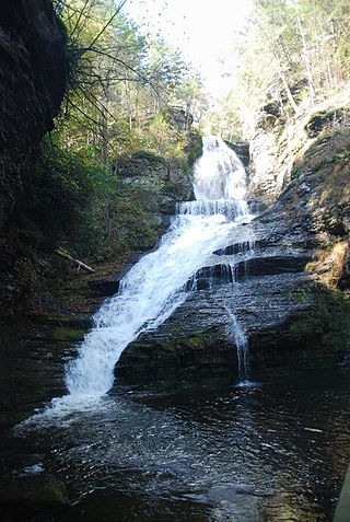
The George W. Childs Recreation Site is a former Pennsylvania state park that is the site of a number of cascade waterfalls along Dingmans Creek; it has been part of the Delaware Water Gap National Recreation Area since 1983. It is located in Dingmans Ferry in Delaware Township, Pike County, Pennsylvania and is named for the late newspaper publisher George William Childs, whose widow deeded the land to the Commonwealth of Pennsylvania in 1912. The site contains three main waterfalls: Factory Falls, Fulmer Falls and Deer Leap Falls and is a few miles upstream from Dingmans Falls and Silverthread Falls.

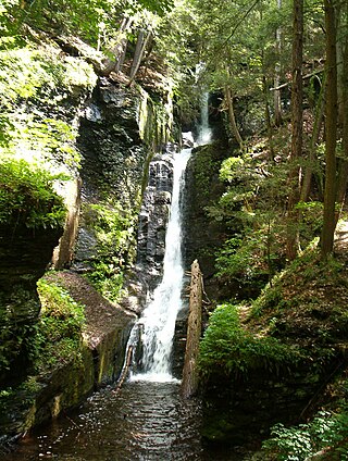
Silverthread Falls is a waterfall located in Dingmans Ferry in Delaware Township, Pike County, Pennsylvania, United States, near Dingmans Falls in the Delaware Water Gap National Recreation Area. It has a vertical drop of 24.3 m (80 ft). Both Silverthread Falls and Dingmans Falls are visible from a handicap-accessible trail. The trail begins at the parking lot for the Dingmans Falls Visitor Center.
Dingmans Falls is a waterfall located in Dingmans Ferry in Delaware Township, Pennsylvania near the Silverthread Falls. It has a vertical drop of 39.6 m (130 ft). Both Silverthread Falls and Dingmans Falls are visible from a handicap-accessible trail. The trail begins at the parking lot for the Dingmans Falls Visitor Center.

Deer Leap Falls is the third waterfall located in the George W. Childs Recreation Site, Pike County, Pennsylvania, United States. It is located downstream from the Factory Falls and Fulmer Falls on the Dingmans Creek.

State Quadrant Route 2001 in Pike County, Pennsylvania is a 22-mile (35 km) road in Dingman, Lehman, Delaware and Milford Townships. Formerly Pennsylvania Route 962 in part, the road stretches from U.S. Route 209 in Lehman Township to West Harford Street in downtown Milford. There are very few notable roads that intersect with SR 2001, the main three being Pennsylvania Route 739, Log Tavern Road and Raymondskill Road.
Conashaugh, Pennsylvania is a ghost town in Delaware Township, Pike County, Pennsylvania between Dingmans Ferry, Pennsylvania, Milford, Pennsylvania and Birchwood Lakes, Pennsylvania. It is along the Delaware River bordering New Jersey and is now a part of the Delaware Water Gap National Recreation Area. It was originally occupied by American Civil War deserters, and is now considered a ghost town due to the decline of its original population.
Eshback, Pennsylvania is a ghost town in Lehman Township, Pike County, Pennsylvania near Dingmans Ferry, Pennsylvania and Bushkill, Pennsylvania. It is now a part of the Delaware Water Gap National Recreation Area, and the Eshback Boat Launch remains in the park.

Dingman's Ferry Dutch Reformed Church is a historic Dutch Reformed church located on U.S. Route 209 in the Delaware Water Gap National Recreation Area at Dingman's Ferry, Delaware Township, Pike County, Pennsylvania. It was designed in 1837, and built in 1850 in the Greek Revival style. It is a two-story, clapboard clad frame building with a gable roof. It features a large gabled portico supported by four heavy Doric order columns.

The Minisink or Minisink Valley is a loosely defined geographic region of the Upper Delaware River valley in northwestern New Jersey, northeastern Pennsylvania and New York.

Gold Key Lake is a census-designated place located in Dingman Township, Pike County in the state of Pennsylvania. The community is located north of Pennsylvania Route 739 in eastern Pike County surrounding its namesake, Gold Key Lake. It is located between, and borders the CDP communities of, Sunrise Lake and Pocono Woodland Lakes. As of the 2020 census the population was 1,979, with a median household income of $85.833.

Pocono Mountain Lake Estates is a census-designated place located in Lehman Township, Pike County in the state of Pennsylvania. The community is located near U.S. Route 209, and is between and shares borders with two other CDP's, Pine Ridge and Pocono Ranch Lands. As of the 2010 census the population was 842 residents.

Pocono Woodland Lakes is a census-designated place located in Dingman Township, Pike County in the state of Pennsylvania. The community is located between Interstate 84 and Pennsylvania Route 739, and is to the east of and shares a western border with another CDP community, Gold Key Lake. As of the 2010 census the population was 3,209 residents.

Sunrise Lake is a census-designated place and private lake community located in Dingman Township, Pike County in the state of Pennsylvania. The community is located along Pennsylvania Route 739 in eastern Pike County, about eight miles west of the New Jersey state line at the Delaware River. Sunrise Lake is between, and shares borders with, the CDP communities of Conashaugh Lakes and Gold Key Lake. Sunrise Lake shares its name with the lake of the same name that the community surrounds. As of the 2010 census the population was 1,387 residents.

Wallpack Valley is a valley located in Sussex County in northwestern New Jersey formed by Wallpack Ridge on the west, and Kittatinny Mountain on the east. Wallpack Ridge separates the Wallpack Valley from the valley of the Delaware River, and contains the watershed of the Flat Brook and its main tributaries Big Flat Brook and Little Flat Brook. It is a narrow valley, roughly 25 miles (40 km) in length running from Montague Township south of Port Jervis, New York to the Walpack Bend in the Delaware River near Flatbrookville in Walpack Township where the Flat Brook enters the Delaware at 300 feet above sea level.


