Minisink

Last updated
Fog surrounds cliffs looming over the Delaware River whose valley is the core of the historic Minisink region, July 2007 Delaware Water Gap cliffs.jpg
Fog surrounds cliffs looming over the Delaware River whose valley is the core of the historic Minisink region, July 2007

The Minisink or (more recently) Minisink Valley is a loosely defined geographic region of the Upper Delaware River valley in northwestern New Jersey (Sussex and Warren counties), northeastern Pennsylvania (Pike and Monroe counties) and New York (Orange and Sullivan counties).

Contents

The name was derived by Dutch colonists from the Munsee name for the area, as bands of their people took names after geographic places which they inhabited as territory throughout the mid-Atlantic area. Originally inhabited by Munsee, the northern branch of the Lenape or Delaware Indians, the area's first European settlers arrived in the late seventeenth and early eighteenth centuries and were Dutch and French Huguenot families from colonial New York's Hudson River Valley. The term "Minisink" is not used often today. It is preserved because of its historical relevance concerning the early European settlement of the region during the American colonial period and as an artifact of the early "first contact" between Native Americans and early European explorers, traders and missionaries in the seventeenth century.

Much of the historical Minisink region has been incorporated into the Delaware Water Gap National Recreation Area after defeat of a controversial dam project proposed to be built by U.S. Army Corps of Engineers on the Delaware River near Tocks Island.

Meaning of the name "Minisink"

Minisink Island's north end (center) seen from the Delaware Water Gap National Recreation Area's Cliff Trail in Pennsylvania Minisink Island upstream end 4.jpg
Minisink Island's north end (center) seen from the Delaware Water Gap National Recreation Area's Cliff Trail in Pennsylvania

The name Minisink comes from the Munsee dialect of Lenape, a group of similar Algonquian dialects that were spoken by the various groups of Lenape, or Delaware Indians who inhabited the region before European colonization. Minisink means "at the island" from the Algonquin root word minis, meaning island.[ citation needed ]

During the colonial period, the Minisink was also an area of significant skirmishes and raids between British and French-allied forces in the French and Indian War (the North American front of the Seven Years' War). In response to attacks by larger forces of Delaware, Benjamin Franklin ordered the construction of a series of forts along the Pennsylvanian side of the Delaware River. These forts included Fort Hyndshaw, Fort Dupuy, Fort Norris, and Fort Hamilton, among others. [1] [2]

Earlier historians posited that Minisink meant "people of the stony country" or "where the stones are gathered together." However, Smithsonian linguist Ives Goddard states that any of the attempts to derive either Minisink or Munsee from words meaning "stone" or "mountain," as proposed by these writers (including Lenape scholar Daniel G. Brinton), are incorrect. [3]

Geology and geography

Matamoras, PA (L), the Delaware River (Center), and Port Jervis, NY (R) 2014-08-28 16 34 04 View northwest from the north corner of the base of High Point Monument in High Point State Park, New Jersey.JPG
Matamoras, PA (L), the Delaware River (Center), and Port Jervis, NY (R)

Defining the Minisink area

The Minisink has never been known as a region with distinct, set boundaries. It generally has been conceived as the valley of the Delaware River going northward from the Delaware Water Gap and including the valley of the Neversink River (a tributary entering the Delaware near Port Jervis, New York). According to Vosburgh, "The 'Minisink county' consists of the valley of the Neversink west of the Shawangunk Mountains, and the Delaware valley, as far as the Delaware Water Gap." [4] Some sources imply that it was confined to the width of valley of the Delaware and its surrounding hillsides.

Other sources define the region as an area extending for 20–30 miles to the east and west of the river. This latter definition would include parts or all of the Kittatinny Valley to the east of Kittatinny Mountain in New Jersey, and westward deep into northeastern Pennsylvania. East of the Shawangunk ridge, in New York are the Town of Greenville and the Town of Minisink, both often included as part of the Minisink region. [5] [6] Their residents attend Minisink Valley Central School District.

Course of the Delaware River

The Delaware River was often referred to as the Minisink River in early Dutch colonial documents and on early maps. The Delaware River constitutes part of the boundary between Pennsylvania and New York, and the entire boundary between New Jersey and Pennsylvania. The middle section of the Delaware River's course, roughly between Port Jervis, New York and the Delaware Water Gap (a break in Kittatinny Mountain where the river runs through) constitutes the north and southern points of the Minisink or Minisink Valley. The river flows down a broad Appalachian valley. The Minisink is a buried valley, where the Delaware flows in a bed of glacial till that buried the eroded bedrock during the last glacial period.

At Port Jervis, New York, the river enters the Port Jervis trough. At this point, the Walpack Ridge deflects the Delaware into the Minisink Valley. It follows the southwest strike of the eroded Marcellus Formation beds along the Pennsylvania–New Jersey state line for 25 miles (40 km) to the end of the ridge at Walpack Bend in Walpack Township, New Jersey in the Delaware Water Gap National Recreation Area. [7] [8] It skirts the Kittatinny ridge, which it crosses at the Delaware Water Gap, between nearly vertical walls of sandstone, quartzite, and conglomerate.

Appalachian Mountains

The features of the Ridge and Valley province were created approximately 300–400 million years ago during the Ordovician period and Appalachian orogeny—a period of tremendous pressure and rock thrusting that caused the creation of the Appalachian Mountains. [9] [10] This physiographic province occupies approximately two-thirds of the county's area—the county's western and central sections. Its contour is characterized by long, even ridges with long, continuous valleys in between that generally run parallel from southwest to northeast. This region is largely formed by sedimentary rock. [11] [12]

Kittatinny Mountain is the dominant geological feature in the parts of the Minisink located within New Jersey. It is part of the Appalachian Mountains, and part of a ridge that continues as the Blue Ridge or Blue Mountain in Eastern Pennsylvania, and as Shawangunk Ridge in New York. It begins in New Jersey as the eastern half of the Delaware Water Gap, and runs northeast to southwest along the Delaware River. Elevations range from 1,200 to 1,800 feet and attains a maximum elevation of 1,803 feet at High Point, in Montague Township. [13] Between Kittatinny Mountain and the Delaware River is the Walpack Ridge, with elevations of 500 to 800 feet. [13] It is a smaller ridge that parallels Kittatinny Mountain between the Walpack Bend and Port Jervis, New York, and encloses the watershed of the Flat Brook which is also called Walpack Valley.

The Kittatinny Valley lies to the east of Kittatinny Mountain and ends with the Highlands in the east. It is largely a region of rolling hills and flat valley floors. Elevations in this valley range from 400 to 1,000 feet. [13] It is part of the Great Appalachian Valley running from eastern Canada to northern Alabama. This valley is shared by three major watersheds—the Wallkill River, with its tributaries Pochuck Creek and Papakating Creek flowing north; and the Paulins Kill watershed and Pequest River watershed flowing southwest.

Kittatinny's valley floor is part of the Ordovician Martinsburg Formation (shale and slate) which make up most of the valley—and the Jacksonburg Formation (mostly limestone). The mountain is of the Silurian Shawangunk Conglomerate which is mainly composed of quartz. Due to the hardness of the quartz, the mountain is extremely resistant to weathering.

History

The Lenape and other cultures

Map showing the aboriginal boundaries of Lenape territories divided by dialect with Munsee territory (including the Minisink Valley) in the lightly shaded northernmost area Delaware01.png
Map showing the aboriginal boundaries of Lenape territories divided by dialect with Munsee territory (including the Minisink Valley) in the lightly shaded northernmost area

This area was occupied for thousands of years by succeeding cultures of indigenous peoples. At the time of European encounter, the historic Lenape ( /ˈlɛnəp/ or /ləˈnɑːpi/ ), a Native American people, also called Delaware Indians after their historic territory along the Delaware River, inhabited the mid-Atlantic coastal areas and inland along the Hudson and Delaware rivers. [14] As a result of disruption following the French and Indian War (1756–1763) the American Revolutionary War (1775–1783) and later Indian removals from the eastern United States, the main groups now live in Ontario (Canada), and Wisconsin and Oklahoma in the United States. In Canada, they are enrolled in the Munsee-Delaware Nation, the Moravian of the Thames First Nation, and the Delaware of Six Nations. In the United States, they are enrolled in three federally recognized tribes, the Delaware Nation and the Delaware Tribe of Indians located in Oklahoma, and the Stockbridge-Munsee Community, located in Wisconsin. The Ramapough Mountain Indians and the Nanticoke Lenni-Lenape, recognized as tribes by the state of New Jersey, identify as Lenape descendants.

Settlement by Dutch and Huguenot families

Condemnation

The Delaware River is prone to floods—some resulting from seasonal snow melt or rain run-off from heavy rainstorms. However, record flooding occurred in August 1955 in the aftermath of two separate hurricanes (Hurricane Connie and Hurricane Diane) that passed over the area within the span of one week. On 19 August 1955, the river gauge at Riegelsville, Pennsylvania recorded that the Delaware River reached a crest of 38.85 feet (11.84 m) above flood stage.

A project to dam the river near Tocks Island was in the works before the 1955 floods. But several deaths and severe damages resulting from these floods brought the issue of flood control to the national level. The U.S. Army Corps of Engineers proposed the construction of the dam which would have created a 37-mile (60-km) long lake between Pennsylvania and New Jersey, with depths of up to 140 feet. The area around the lake would be established as the Tocks Island National Recreation Area under the oversight of the National Park Service to offer recreation activities such as hunting, hiking, fishing, and boating. In addition to flood control and recreation, the dam would be used to generate hydroelectric power, and provide a clean water supply to New York City and Philadelphia.

Starting in 1960, the present day area of the Recreation Area was acquired for the Army Corps of Engineers through eminent domain. Approximately 15,000 people were displaced by the condemnation of personal property along the Delaware River and the surrounding area through eminent domain. An estimated 3,000 to 5,000 dwellings and outbuildings were demolished in preparation for the dam project and subsequent flooding of the valley. This included many irreplaceable historical sites and structures connected with the valley's colonial and Native American heritage. The plan was embroiled in controversy and protest by environmental groups and embittered displaced residents. Because of considerable opposition from environmental activists, the unavailability of government funding, and a geological assessment of the dam's safety given its location near active fault lines, the federal government transferred the property to the National Park Service in 1978 and the project's land holdings were reorganized to create the Delaware Water Gap National Recreation Area. [15] [16] [17] [18]

See also

Related Research Articles

<span class="mw-page-title-main">Delaware River</span> Major river on the East Coast of the United States

The Delaware River is a major river in the Mid-Atlantic region of the United States. From the meeting of its branches in Hancock, New York, the river flows for 282 miles (454 km) along the borders of New York, Pennsylvania, New Jersey, and Delaware, before emptying into Delaware Bay. It is the longest free-flowing river in the Eastern United States.

<span class="mw-page-title-main">Great Appalachian Valley</span> Major landform in eastern South America

The Great Appalachian Valley, also called The Great Valley or Great Valley Region, is one of the major landform features of eastern North America. It is a gigantic trough—a chain of valley lowlands—and the central feature of the Appalachian Mountains system. The trough stretches about 1,200 miles (1,900 km) from Quebec in the north to Alabama in the south and has been an important north–south route of travel since prehistoric times.
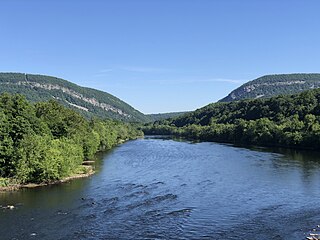
<span class="mw-page-title-main">Delaware Water Gap</span> Geological feature along the Delaware River

Delaware Water Gap is a water gap on the border of the U.S. states of New Jersey and Pennsylvania where the Delaware River cuts through a large ridge of the Appalachian Mountains.

<span class="mw-page-title-main">Lenapehoking</span> Lands traditionally inhabited by the Lenape people

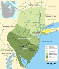
Lenapehoking is widely translated as 'homelands of the Lenape', which in the 16th and 17th centuries, ranged along the Eastern seaboard from western Connecticut to Delaware, and encompassed the territory adjacent to the Delaware and lower Hudson river valleys, and the territory between them.

<span class="mw-page-title-main">Shawangunk Ridge</span> Ridge of bedrock in the state of New York

The Shawangunk Ridge, also known as the Shawangunk Mountains or The Gunks, is a ridge of bedrock in Ulster County, Sullivan County and Orange County in the state of New York, extending from the northernmost point of the border with New Jersey to the Catskills. The Shawangunk Ridge is a continuation of the long, easternmost section of the Appalachian Mountains; the ridge is known as Kittatinny Mountain in New Jersey, and as Blue Mountain as it continues through Pennsylvania. This ridge constitutes the western border of the Great Appalachian Valley.

<span class="mw-page-title-main">Endless Mountains</span> Mountainous region in northeast Pennsylvania

The Endless Mountains are a geographical, geological, and cultural region in Northeastern Pennsylvania. The Endless Mountains region includes Bradford, Sullivan, Susquehanna, and Wyoming counties. The highest peak in the region is the North Knob of Elk Mountain at 2,693 feet.

<span class="mw-page-title-main">Tocks Island Dam controversy</span>

A 1950s proposal to construct a dam near Tocks Island across the Delaware River was met with considerable controversy and protest. Tocks Island is located in the Delaware River a short distance north from the Delaware Water Gap. In order to control damaging flooding and provide clean water to supply New York City and Philadelphia, the U.S. Army Corps of Engineers proposed building a dam. When completed, the Tocks Island Dam would have created a 37-mile (60-km) long lake between Pennsylvania and New Jersey, with depths of up to 140 feet. This lake and the land surrounding were to be organized as the Tocks Island National Recreation Area. Although the dam was never built, 72,000 acres (291 km²) of land were acquired by condemnation and eminent domain. This incited environmental protesters and embittered local residents displaced by the project's preparations when their property was condemned. After the Tocks Island Dam project was withdrawn, the lands acquired were transferred to the oversight of the National Park Service which reorganized them to establish the Delaware Water Gap National Recreation Area.

<span class="mw-page-title-main">Kittatinny Mountain</span> Ridge in northwestern New Jersey

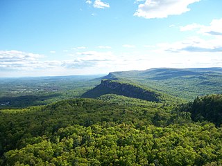
Kittatinny Mountain is a long ridge traversing primarily across Sussex County in northwestern New Jersey, running in a northeast-southwest axis, a continuation across the Delaware Water Gap of Pennsylvania's Blue Mountain. It is the first major ridge in the far northeastern extension of the Ridge and Valley province of the Appalachian Mountains, and reaches its highest elevation, 1,803 feet, at High Point in Montague Township. Kittatinny Mountain forms the eastern side of Wallpack Valley; the western side comprises the Wallpack Ridge (highest elevation: 928 feet above sea level.

<span class="mw-page-title-main">Blue Mountain (Pennsylvania)</span> Ridge in Pennsylvania, United States

Blue Mountain, Blue Mountain Ridge, or the Blue Mountains of Pennsylvania, is a ridge of the Appalachian Mountains in eastern Pennsylvania. Forming the southern and eastern edge of the Ridge-and-Valley Appalachians physiographic province in Pennsylvania, Blue Mountain extends 150 miles (240 km) from the Delaware Water Gap on the New Jersey border in the east to Big Gap in Franklin County in south-central Pennsylvania at its southwestern end.

<span class="mw-page-title-main">Delaware Water Gap National Recreation Area</span> Protected area

Delaware Water Gap National Recreation Area is a 70,000-acre (28,000 ha) national recreation area administered by the National Park Service in northwest New Jersey and northeast Pennsylvania. It is centered around a 40-mile (64 km) stretch of the Delaware River designated the Middle Delaware National Scenic River. At the area's southern end lays the Delaware Water Gap, a dramatic mountain pass where the river cuts between Blue Mountain and Kittatinny Mountain

<span class="mw-page-title-main">Flat Brook</span>

Flat Brook, also spelled as Flatbrook, is an 11.6-mile-long (18.7 km) tributary of the Delaware River in Sussex County, New Jersey in the United States.

<span class="mw-page-title-main">Paulins Kill</span> River in New Jersey, United States

The Paulins Kill is a 41.6-mile (66.9 km) tributary of the Delaware River in northwestern New Jersey in the United States. With a long-term median flow rate of 76 cubic feet of water per second (2.15 m³/s), it is New Jersey's third-largest contributor to the Delaware River, behind the Musconetcong River and Maurice River. The river drains an area of 176.85 square miles (458.0 km2) across portions of Sussex and Warren counties and 11 municipalities. It flows north from its source near Newton, and then turns southwest. The river sits in the Ridge and Valley geophysical province.

Old Mine Road is a road in New Jersey and New York said to be one of the oldest continuously used roads in the United States of America. At a length of 104 miles (167 km), it stretches from the Delaware Water Gap National Recreation Area to the vicinity of Kingston, New York.

Pahaquarry Township is a now-defunct township that was located in Warren County, New Jersey, United States, from 1824 until it was dissolved in 1997.

<span class="mw-page-title-main">Stokes State Forest</span>

Stokes State Forest is a state park located in Sandyston, Montague and Frankford in Sussex County, New Jersey, United States. Stokes comprises 16,447 acres (66.56 km2) of mountainous woods in the Kittatinny Mountains, extending from the southern boundary of High Point State Park southwestward to the eastern boundary of the Delaware Water Gap National Recreation Area. The park is operated and maintained by the New Jersey Division of Parks and Forestry.

New Jersey is a very geologically and geographically diverse region in the United States' Middle Atlantic region, offering variety from the Appalachian Mountains and the Highlands in the state's northwest, to the Atlantic Coastal Plain region that encompasses both the Pine Barrens and the Jersey Shore. The state's geological features have impacted the course of settlement, development, commerce and industry over the past four centuries.

<span class="mw-page-title-main">Kittatinny Valley</span>

The Kittatinny Valley is a section of the Great Appalachian Valley in Sussex and Warren counties in northwestern New Jersey that is bounded on the northwest by Kittatinny Mountain, and in the southeast by the New Jersey Highlands region. The valley is roughly 40 miles (64 km) long, with a breadth of 10 to 13 miles.

<span class="mw-page-title-main">Pahaquarry Copper Mine</span> United States historic place

The Pahaquarry Copper Mine is an abandoned copper mine located on the west side of Kittatinny Mountain presently in Hardwick Township in Warren County, New Jersey in the United States. Active mining was attempted for brief periods during the mid-eighteenth, mid-nineteenth, and early twentieth centuries but was never successful despite developments in mining technology and improving mineral extraction methods. Such ventures were not profitable as the ore extracted proved to be of too low a concentration of copper. This site incorporates the mining ruins, hiking trails, and nearby waterfalls, and is located within the Delaware Water Gap National Recreation Area and administered by the National Park Service. It was added to the National Register of Historic Places in 1980 as a contributing property to the Old Mine Road Historic District.

<span class="mw-page-title-main">Wallpack Ridge</span>

Wallpack Ridge is a mountain located in the Ridge and Valley Appalachians physiographic province in Sussex County in northwestern New Jersey. Oriented northeast to southwest, Wallpack Ridge spans 25 miles (40 km) from Montague Township south of Port Jervis, New York to the Walpack Bend in the Delaware River near Flatbrookville in Walpack Township. It is a narrow ridge ranging between 0.67 miles (1.08 km) to 1.7 miles (2.7 km) in width, and its highest elevation reaches 928 feet (283 m) above sea level. The ridge separates the Wallpack Valley from the valley of the Delaware River, and contains the watershed of the Flat Brook and its main tributaries Big Flat Brook and Little Flat Brook.

<span class="mw-page-title-main">Wallpack Valley</span>

Wallpack Valley is a valley located in Sussex County in northwestern New Jersey formed by Wallpack Ridge on the west, and Kittatinny Mountain on the east. Wallpack Ridge separates the Wallpack Valley from the valley of the Delaware River, and contains the watershed of the Flat Brook and its main tributaries Big Flat Brook and Little Flat Brook. It is a narrow valley, roughly 25 miles (40 km) in length running from Montague Township south of Port Jervis, New York to the Walpack Bend in the Delaware River near Flatbrookville in Walpack Township where the Flat Brook enters the Delaware at 300 feet above sea level.

References

  1. Old fort sites create sense of Colonial past, Pocono Record, October 19, 2012 http://www.poconorecord.com/apps/pbcs.dll/article?AID=/20121019/NEWS13/210190367/-1/rss28 Accessed September 17, 2013
  2. Oplinger, Carl. The Poconos: An Illustrated Natural History Guide, Rutgers University Press, 2006, page 248
  3. Goddard, Ives. "Delaware" in Trigger, Bruce (editor) Handbook of North American Indians, Volume 15. Northeast. (Washington: The Smithsonian Institution, 1978), 237.
  4. Vosburgh, Royden Woodword (editor). (1913, 1992) Minisink Valley Reformed Dutch Church records, 1716-1830. New York: New York Genealogical and Biographical Society; reprinted Bowie, Maryland: Heritage Books, Inc. : iii.
  5. Osborne, Peter. "The Minisink Valley c. 1650 - c. 1783". Maps of the Region. Minisink Valley Historical Society. Retrieved 24 March 2015.
  6. Hankins, Grace Coyle (1938). True Stories of New Jersey. Philadelphia: John C. Winston Company. p. 144.
  7. Witte, Ron W. and Monteverde, Donald H. "Karst in the Delaware Water Gap National Recreation Area", in Unearthing New Jersey Vol. 2, No. 1 (1 February 2006). (Trenton: New Jersey Geological Survey, Department of Environmental Protection).
  8. White, I.C. and Chance, H.M. The Geology of Pike and Monroe Counties Second Geological Survey of Pennsylvania, Report of Progress, G6 (Harrisburg, Pennsylvania: 1882), 17, 73–80, 114–115.
  9. Hatcher, Robert D., Jr. "Tracking lower-to-mid-to-upper crustal deformation processes through time and space through three Paleozoic orogenies in the Southern Appalachians using dated metamorphic assemblages and faults," in Abstracts with Programs (Geological Society of America), Vol. 40, No. 6, 513. located online here Archived 2018-08-06 at the Wayback Machine (Retrieved August 28, 2012)
  10. Bartholomew, M.J., and Whitaker, A.E., 2010, "The Alleghanian deformational sequence at the foreland junction of the Central and Southern Appalachians", in Tollo, R.P., Bartholomew, M.J., Hibbard, J.P., and Karabinos, P.M., eds., From Rodinia to Pangea: The Lithotectonic Record of the Appalachian Region, GSA Memoir 206, p. 431-454.
  11. Lucey, Carol S. Geology of Sussex County in Brief. (Trenton, NJ: New Jersey Geological Survey, November 1969), 21pp. located online here (Retrieved August 28, 2012).
  12. Dalton, Richard. "New Jersey Geological Survey Information Circular: Physiographic Provinces of New Jersey" (Trenton, NJ: Department of Environmental Protection, State of New Jersey, 2003, 2006), 2pp. located online here (Retrieved August 28, 2012).
  13. 1 2 3 U.S. Department of Agriculture Natural Resource Conservation Service. Soil Survey of Sussex County, New Jersey (Washington, DC: 2009), 3.
  14. Goddard, Ives (1978). "Delaware". In Bruce G. Trigger (ed.). Handbook of North American Indians, vol. 15: Northeast. Washington. pp. 213–239.
  15. Obiso, Laura. Delaware Water Gap National Recreation Area (2008), 7-8.
  16. Delaware Water Gap National Recreation Area, njskylands.com.
  17. See: Feiveson, Harold; Sinden, Frank; and Socolow, Robert. Boundaries of Analysis: An Inquiry Into the Tocks Island Dam Controversy. (1976). Albert, Richard C. Damming the Delaware: The Rise and Fall of Tocks Island Dam (Pennsylvania State University Press, 1987).
  18. The Legacy of Tocks Island, Pocono Record, August 12, 2001

Coordinates: 41°05′36″N74°59′32″W / 41.093454°N 74.992247°W / 41.093454; -74.992247