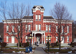
Wayne is a county in the Commonwealth of Pennsylvania. It is part of Northeastern Pennsylvania. The county's population was 51,155 at the 2020 census. The county seat is the Borough of Honesdale. The county was formed from part of Northampton County on March 21, 1798, and was named for the Revolutionary War General Anthony Wayne.

Pike County is a county in the Commonwealth of Pennsylvania. It is part of Northeastern Pennsylvania. As of the 2020 census, the population was 58,535. Its county seat is Milford.
Mount Cobb is an unincorporated community and census-designated place (CDP) in Lackawanna County, Pennsylvania, United States. The population was 1,799 at the 2010 census.

Dupont is a borough in the Greater Pittston area of Luzerne County, Pennsylvania, United States. The population was 2,536 as of the 2020 census.
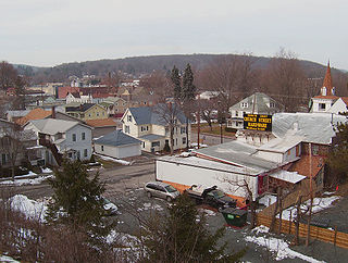
Hawley is a borough on the Lackawaxen River in Wayne County, Pennsylvania, United States. The borough's population was 1,229 at the time of the 2020 United States Census.

Palmyra is a second-class township in Wayne County, Pennsylvania. The township's population was 1,339 at the time of the 2010 United States Census.

Paupack is a second-class township in Wayne County, Pennsylvania, United States. The township's population was 3,828 at the time of the 2010 United States Census.

Thornton Township is one of 29 townships in Cook County, Illinois. As of the 2020 census, its population was 157,865.

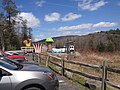
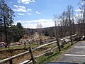
Newfoundland is a village in Dreher Township, Wayne County, Pennsylvania, United States. It is most famously known as host to the Greene-Dreher-Sterling Fair every Labor Day weekend.
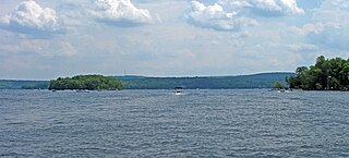
Lake Wallenpaupack is a reservoir in Northeastern Pennsylvania. After Raystown Lake, it is the second-largest lake contained entirely in Pennsylvania. It comprises 52 miles of shoreline, with a length of 13 miles and a maximum depth of 60 feet, and has a surface area in excess of 5,700 acres. It was created in 1926 by the PPL Corporation for hydroelectric purposes as well as flood control; however, it is best known as one of several major recreational destinations in the Pocono Mountains. It is located near the Borough of Hawley, and forms part of the boundary between Pike and Wayne counties. See map.
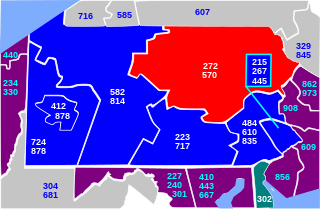
Area codes 570 and 272 are telephone area codes in the North American Numbering Plan (NANP) for the northeast quadrant of the U.S. state of Pennsylvania. The numbering plan area (NPA) includes the cities or towns of Scranton, Wilkes-Barre, Williamsport, Stroudsburg, East Stroudsburg, Pittston, Carbondale, Hazleton, Clarks Summit, Towanda, Bloomsburg, Sayre, Tunkhannock, Berwick, Milford, Montrose, Honesdale, Pocono Pines, Nanticoke, Tamaqua, Shavertown, Dallas, Mahanoy City, Sunbury, Jim Thorpe, and extends as far south as Pottsville and as far west as Lock Haven. Area code 570 was created in 1998 in an split of area code 717, one of the original North American area codes. In 2013, the numbering plan area received a second area code, 272, creating an overlay plan, which required ten-digit dialing for the area.
Wallenpaupack Creek is a 30.0-mile-long (48.3 km) tributary of the Lackawaxen River in the Pocono Mountains of eastern Pennsylvania in the United States.

Pennsylvania Route 390 is a 25.3-mile-long (40.7 km) state highway located in Monroe and Pike counties in Pennsylvania. The southern terminus is at PA 940 in Paradise Township. The northern terminus is at PA 507 in Tafton View. The route is a two-lane undivided road that runs through forested areas in the Pocono Mountains. PA 390 begins at PA 940 west of Paradise Valley and heads northeast. The route runs concurrent with PA 191 between Cresco and Mountainhome before it splits and intersects PA 447 in Canadensis. PA 390 passes through Skytop before it crosses the county line and runs through Promised Land State Park. The route has an interchange with Interstate 84 (I-84) before passing through Tafton and ending at PA 507 near Lake Wallenpaupack.

Pennsylvania Route 507 is a 27.2-mile-long (43.8 km) state highway located in Monroe, Wayne, and Pike counties in Pennsylvania. The southern terminus is at PA 435 and at an interchange with Interstate 380 (I-380) near Gouldsboro. The northern terminus is at U.S. Route 6 in Palmyra Township. PA 507 runs southwest-northeast as a two-lane undivided through forests in the upper reaches of the Pocono Mountains, with the northern section nearly parallel to Lake Wallenpaupack. The route passes through Gouldsboro before it crosses PA 196 in Angels. In Newfoundland, PA 507 and PA 191 run concurrent for about 2 miles (3.2 km) and intersect the north end of PA 447. After splitting from PA 191, the route has an interchange with I-84 and a junction with the northern terminus of PA 390 before ending at US 6. PA 507 was designated between US 611 west of Gouldsboro and US 6 in Tafton in 1928. The route was fully paved by the 1930s and has remained on the same alignment since.

Pennsylvania Route 590 is a 45.0-mile-long (72.4 km) state highway located in Lackawanna, Wayne, and Pike counties in Pennsylvania. The western terminus is at PA 435 in Elmhurst Township. The eastern terminus is at PA 434 in the community of Greeley in Lackawaxen Township. PA 590 is mostly a two-lane road that runs through rural areas in Northeastern Pennsylvania. The route serves the communities of Hamlin, Hawley, and Lackawaxen and passes to the north of Lake Wallenpaupack. PA 590 has intersections with PA 690 and PA 348 in Hollisterville, PA 191/PA 196 in Hamlin, and U.S. Route 6 in Hawley.

Pennsylvania Route 790 was a state highway in the county of Pike in Pennsylvania, USA. The highway's southern terminus was at State Route 290 south of Hemlock Grove. The highway progressed northward along Hemlock Grove Road, passing through Hemlock Grove and into Greentown, where it terminated at an intersection with State Route 507. The highway was assigned in 1930 and decommissioned in the 1946 removal of state highways.
The land of Wilsonville, Pennsylvania and the surrounding area in the valley was purchased by PPL Corporation from about 100 owners at about $20 an acre, and all property was razed or moved in order to build a dam to create what is now Lake Wallenpaupack. Seventeen miles of roads and telephone poles were rerouted, and one cemetery had to be relocated. The original town of Wilsonville now lies under the water near the dam.
East Winthrop is a village in the town of Winthrop in Kennebec County, Maine, United States. It is located just west of Manchester and south of Readfield, borders most of Cobbosseecontee Lake, and all of Little Cobbosseecontee, Upper and Lower Narrows. It has a separate post office and ZIP code (04343) from the rest of Winthrop, although this serves only mail delivered to post office boxes in the East Winthrop Post Office. The area has magnificent views of the Cobbosseecontee bodies of water.

Wallenpaupack Lake Estates is a private community and census-designated place in Paupack Township, Wayne County in the U.S. State of Pennsylvania. The community's population was 1,279 as of the 2010 United States Census.

Interstate 84 (I-84) in Pennsylvania is the westernmost segment of the eastern I-84. Within Pennsylvania, it runs from I-81 in Dunmore east to the New York border near Matamoras.