This article needs additional citations for verification .(November 2012) |
Butts Bridge | |
 Butts Bridge | |
  | |
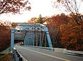
| Location | Butts Bridge Road over Quinebaug R., Canterbury, Connecticut |
|---|---|
| Coordinates | 41°39′5″N71°58′15″W / 41.65139°N 71.97083°W |
| Area | 0.2 acres (0.081 ha) |
| Built | 1936 |
| Architect | Connecticut State Highway Dept. |
| Architectural style | Parker through truss |
| NRHP reference No. | 10000272 [1] |
| Added to NRHP | May 24, 2010 |
The Butts Bridge carries Butts Bridge Road (Connecticut Route 668) over the Quinebaug River in the town of Canterbury, Connecticut. It is a well-preserved example of a Parker truss, built in 1937, late in the state's regular use of steel truss bridge designs. The bridge is also known as Bridge No. 1649 and carries an average of 2,300 vehicles per day as of 2011. It was listed on the National Register of Historic Places in 2010. [1]