Cal-Nev-Ari, Nevada

Last updated
Cal-Nev-Ari, Nevada
Cal-Nev-Ari Nevada from Spirit Mountain 1.jpg
Seen from Spirit Mountain to the east; New York Mountains in the distance
Clark County Nevada Incorporated Areas Cal Nev Ari highlighted.svg
Location of Cal-Nev-Ari in Clark County, Nevada
Usa edcp location map.svg
Red pog.svg
Cal-Nev-Ari, Nevada
Location in the United States
Coordinates: 35°18′12″N114°52′51″W / 35.30333°N 114.88083°W / 35.30333; -114.88083
Country United States
State Nevada
County Clark
Founded1960s;61 years ago (1960s)
Named for California, Nevada and Arizona
Area
[1]
  Total2.28 sq mi (5.90 km2)
  Land2.28 sq mi (5.90 km2)
  Water0.00 sq mi (0.00 km2)
Elevation
2,579 ft (786 m)
Population
 (2020)
  Total144
  Density63.19/sq mi (24.39/km2)
Time zone UTC-8 (PST)
  Summer (DST) UTC-7 (PDT)
ZIP code
89039
Area code(s) 702 and 725
FIPS code 32-08600
GNIS feature ID0858257

Cal-Nev-Ari is a census-designated place on U.S. Route 95 in Clark County, Nevada, United States, near the state's southernmost point. As of the 2010 census, the town had a population of 244. [2] The town's name is a syllabic abbreviation of California, Nevada and Arizona.

Contents

Cal-Nev-Ari was created in the mid-1960s by Nancy and Everette "Slim" Kidwell, who acquired a 640-acre (260 ha; 1.00 sq mi) section of land from the U.S. government and commenced development of an airport-based community an hour by road from Las Vegas. In addition to the FAA-designated Kidwell Airport, the community has grown over the years to include a casino, motel, RV and mobile home parks, convenience market, and over 100 residential lots.

The town was listed for sale in 2016 for $8 million [3] although it had been originally listed in 2010 for $17 million. [4] It sold for the $8 million price to Heart of Nature, an organic minerals company, which plans to use the water to manufacture sulfur products for farms. [5] [6]

Geography

Cal-Nev-Ari is located at 35°18′12″N114°52′51″W / 35.30333°N 114.88083°W / 35.30333; -114.88083 Coordinates: 35°18′12″N114°52′51″W / 35.30333°N 114.88083°W / 35.30333; -114.88083 (35.303196, -114.880795). [7]

According to the United States Census Bureau, the CDP has a total area of 2.3 square miles (6.0 km2), all of it land.

Demographics

Historical population
CensusPop.
2020 144
U.S. Decennial Census [8]

At the 2000 census there were 278 people, 154 households, and 93 families in the CDP. The population density was 120.9 inhabitants per square mile (46.7/km2). There were 199 housing units at an average density of 86.5 per square mile (33.4/km2). The racial makeup of the CDP was 95.32% White, 1.80% from other races, and 2.88% from two or more races. Hispanic or Latino of any race were 2.16%. [9]

Of the 154 households 7.1% had children under the age of 18 living with them, 55.8% were married couples living together, 1.9% had a female householder with no husband present, and 39.6% were non-families. Of all households 33.8% were one person and 14.9% were one person aged 65 or older. The average household size was 1.81 and the average family size was 2.20.

The age distribution was 7.6% under the age of 18, 1.1% from 18 to 24, 14.7% from 25 to 44, 42.1% from 45 to 64, and 34.5% 65 or older. The median age was 59 years. For every 100 females, there were 104.4 males. For every 100 females age 18 and over, there were 110.7 males.

The median household income was $42,563 and the median family income was $44,333. Males had a median income of $24,632 versus $19,531 for females. The per capita income for the CDP was $20,870. None of the population or families were below the poverty line.

Related Research Articles

<span class="mw-page-title-main">Golden Valley, Arizona</span> CDP in Mohave County, Arizona

Golden Valley is an unincorporated area and census-designated place (CDP) in Mohave County, Arizona, United States. The population was 8,801 at the 2020 census.

<span class="mw-page-title-main">Dixon, Montana</span> CDP in Montana, United States

Dixon is a census-designated place (CDP) in Sanders County, Montana, United States. The population was 216 at the 2000 census.

<span class="mw-page-title-main">Blue Diamond, Nevada</span> Census-designated place in Clark County, Nevada, United States

Blue Diamond is a census-designated place (CDP) in Clark County, Nevada, United States. The population was 268 at the 2020 census.

<span class="mw-page-title-main">Bunkerville, Nevada</span> Unincorporated town in the State of Nevada, United States

Bunkerville is a census-designated place in Clark County, Nevada, United States. The population was 1,303 at the 2010 census.

<span class="mw-page-title-main">Goodsprings, Nevada</span> Unincorporated community in Nevada, United States

Goodsprings is an unincorporated community in Clark County, Nevada, United States. The population was 229 at the 2010 census.

<span class="mw-page-title-main">Indian Springs, Nevada</span> Unincorporated town in the State of Nevada, United States

Indian Springs is an unincorporated town and a census-designated place located on U.S. Route 95 next to Creech Air Force Base in northwestern Clark County and southern Nevada.

<span class="mw-page-title-main">Moapa, Nevada</span> Census-designated place in Nevada, United States

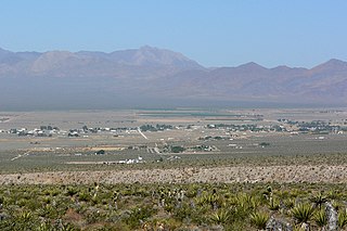
Moapa is an unincorporated town and census-designated place (CDP) in Clark County, Nevada, United States. The population was 1,025 at the 2010 census. It is the largest town in Clark County by land area. Both the second and the third tallest structures in Nevada, the Moapa Entravision Tower and the Moapa Kemp Tower respectively, are located in Moapa.

<span class="mw-page-title-main">Mount Charleston, Nevada</span> Unincorporated town in the State of Nevada, United States

Mount Charleston is an unincorporated town and census-designated place in Clark County, Nevada, United States. The population was 357 at the 2010 census.

<span class="mw-page-title-main">Paradise, Nevada</span> Unincorporated town in the State of Nevada, United States

Paradise is an unincorporated town and census-designated place (CDP) in Clark County, Nevada, United States, adjacent to the city of Las Vegas. It was formed on December 8, 1950. Its population was 191,238 at the 2020 census, making it the fifth most populous CDP in the United States; if it were an incorporated city, it would be the fifth largest in Nevada. As an unincorporated town, it is governed by the Clark County Commission with input from the Paradise Town Advisory Board.

<span class="mw-page-title-main">Sandy Valley, Nevada</span> Unincorporated community in Nevada, United States

Sandy Valley is an unincorporated community in the Mesquite Valley in west–central Clark County, Nevada, United States. Sandy Valley has a variant name of Sandy, Nevada. The population was 2,051 at the 2010 census. Sandy Valley is bordered on the East by the southern extension of the Spring Mountains and on the west by the California state line. Sandy Valley began in the 19th century as the five mining communities of Kingston, Sandy, Ripley, Mesquite and Platina. It is approximately forty-five miles from Las Vegas.

<span class="mw-page-title-main">Searchlight, Nevada</span> Unincorporated town in the State of Nevada, United States

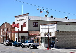
Searchlight is an unincorporated town and census-designated place (CDP) in Clark County, Nevada, United States, at the topographic saddle between two mountain ranges. As of the 2010 census it had a population of 539.

<span class="mw-page-title-main">Spring Valley, Nevada</span> Unincorporated town in the State of Nevada, United States

Spring Valley is an unincorporated town and census-designated place in Clark County, Nevada, United States, located 2 miles (3 km) west of the Las Vegas Strip. The population was 215,597 at the 2020 census. Spring Valley was formed in May 1981.

<span class="mw-page-title-main">Sunrise Manor, Nevada</span> Census-designated place in Clark County, Nevada, United States

Sunrise Manor is a census-designated place in Clark County, Nevada, United States, located on the western base of Frenchman Mountain, east of Las Vegas. The population was 205,618 at the 2020 census. If Sunrise Manor were to be incorporated, it would be one of the largest cities in Nevada. Sunrise Manor was formed in May 1957.

<span class="mw-page-title-main">Whitney, Nevada</span> Unincorporated town in the State of Nevada, United States

Whitney is an unincorporated town and census-designated place in Clark County, Nevada, United States. The population was 38,585 at the 2010 census.

<span class="mw-page-title-main">Winchester, Nevada</span> Unincorporated town in the State of Nevada, United States

Winchester is an unincorporated town and census-designated place (CDP) in Clark County, Nevada, United States that contains part of the Las Vegas Strip. It is one of a number of CDPs in the unincorporated urbanized area directly south of Las Vegas. The population was 36,403 at the 2020 census. It is governed by the Clark County Commission with advice from the Winchester Town Advisory Board. "Winchester, NV" does not appear in postal addresses; the United States Postal Service has assigned "Las Vegas, NV" as the place name for the ZIP codes containing Winchester.

<span class="mw-page-title-main">Stateline, Nevada</span> CDP in Nevada, United States

Stateline is a census-designated place (CDP) on the southeastern shore of Lake Tahoe in Douglas County, Nevada, United States. It lies next to the California state line and City of South Lake Tahoe. The population was 842 at the 2010 census. The population swells considerably during the busy winter and summer seasons, due to the high number of hotel rooms and rental accommodations available.

<span class="mw-page-title-main">Schurz, Nevada</span> CDP in Nevada, United States

Schurz is a census-designated place (CDP) in Mineral County, Nevada, United States. The population was 658 at the 2010 census. It is located on the Walker River Indian Reservation. It is the burial place of Wovoka, the Paiute messiah who originated the Ghost Dance movement.

<span class="mw-page-title-main">Gabbs, Nevada</span> Unincorporated town in the State of Nevada, United States

Gabbs is an unincorporated town in Nye County, Nevada, United States. The population was 269 at the 2010 census and it is the northernmost community of Greater Las Vegas.

<span class="mw-page-title-main">McGill, Nevada</span> CDP in Nevada, United States

McGill is a census-designated place (CDP) in White Pine County, Nevada, United States. The population was 1,148 at the 2010 census.

Penfield is an unincorporated census-designated place in Compromise Township, Champaign County, Illinois, United States. Its population was 151 at the 2020 census.

References

  1. "ArcGIS REST Services Directory". United States Census Bureau. Retrieved September 19, 2022.
  2. "Profile of General Population and Housing Characteristics: 2010 Demographic Profile Data (DP-1): Cal-Nev-Ari CDP, Nevada". United States Census Bureau . Retrieved March 9, 2012.
  3. "A town near Vegas including casino and diner is for sale". BBC Newsbeat.
  4. "Quirky Cal-Nev-Ari for sale from the ground up for $17 million". Las Vegas Review-Journal.
  5. "Tiny Nevada desert town sells for $8M". Las Vegas Review-Journal. 2021-08-19. Retrieved 2021-08-21.
  6. "Founder of Cal-Nev-Ari reflects on sale of tiny town". KLAS. 2021-08-21. Retrieved 2021-08-21.
  7. "US Gazetteer files: 2010, 2000, and 1990". United States Census Bureau. 2011-02-12. Retrieved 2011-04-23.
  8. "Census of Population and Housing". Census.gov. Retrieved June 4, 2016.
  9. "U.S. Census website". United States Census Bureau . Retrieved 2008-01-31.