Crystal is a former unincorporated community in Clark County, Nevada, United States. [1] It lies along the Union Pacific Railroad and had a population of 10 in 1941. [2] It is now the site of a highway rest stop.
Historic maps of Nevada locate Crystal, Clark County to be northeast of Las Vegas along Interstate I-15 at Exit 75, which originally was part of the Nevada State Route 40 highway in that area. It is an enclave within the Moapa River Indian Reservation. [3]
The community was named for the crystal rocks near the original town site. [2]

Blue Diamond is a census-designated place (CDP) in Clark County, Nevada, United States. The population was 268 at the 2020 census.

Moapa is an unincorporated town and census-designated place (CDP) in Clark County, Nevada, United States. The population was 1,025 at the 2010 census. It is the largest town in Clark County by land area. Both the second and the third tallest structures in Nevada, the Moapa Entravision Tower and the Moapa Kemp Tower respectively, are located in Moapa.

North Las Vegas is a suburban city in Clark County, Nevada, United States, in the Las Vegas Valley. As of the 2010 census it had a population of 216,961, with an estimated population of 251,974 in 2019. The city was incorporated on May 1, 1946. It is the 4th most populous city in the state of Nevada, and the 77th most populous city in the United States.

St. Thomas, Nevada is a ghost town in Clark County, Nevada, near where the Muddy River flows into the Colorado River. St. Thomas was purchased by the US Federal Government and abandoned as the waters of Lake Mead submerged the town in the 1930s.

Logandale is located in Clark County, Nevada. It was an unincorporated town in Clark County until 1981 when it was merged with Overton to create the unincorporated town of Moapa Valley. The community is the home of the annual Clark County Fair and Rodeo. The Las Vegas Metropolitan Police Department patrols the town.
Glendale is an unincorporated community in Clark County, Nevada, United States. The community is at an elevation of 1,519 feet (463 m).

Arden, Nevada was an unincorporated community in Clark County, Nevada. The area is now part of the town of Enterprise. Located about 7 miles (11 km) southwest of Las Vegas, the area is experiencing rapid growth in housing development on land formerly owned by the Bureau of Land Management.
The Valley of Fire Road is a road in northeastern Clark County, Nevada serving the Valley of Fire State Park. The roadway was previously designated State Route 40, and the segment within the state park is currently designated a Nevada Scenic Byway.
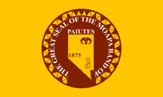
The Moapa Band of Paiute Indians of the Moapa River Indian Reservation are a federally recognized tribe of Southern Paiute, who live in southern Nevada on the Moapa River Indian Reservation. They were in the past called the Muappa / Moapat and the Nuwuvi.
Clark County Museum is located in Henderson, Nevada and is owned and operated by Clark County. The museum includes the Anna Roberts Parks Exhibit Hall and Heritage Street which contains eight historic buildings from the county.

Gold Butte is the name of a ghost town and nearby mountain peak in Clark County, Nevada. Both are protected as part of the Gold Butte National Monument, managed by the Bureau of Land Management. Gold Butte, the mountain, is 5,013 feet (1,528 m) high and rises 1,280 feet (390 m) above the town of Gold Butte. This peak lies within the Virgin Mountains and its name apparently refers to the Gold Butte Mining District.
Sprucemont is a ghost town in Elko County, in the U.S. state of Nevada. The GNIS classifies it as a populated place.
El Dorado City, which is now a ghost town, was a mining camp in the Colorado Mining District at the mouth of January Wash at its confluence with El Dorado Canyon. It was located about a mile down the canyon from Huse Spring, at an elevation of 2382 feet. Its site was located nearby to the south southeast of the Techatticup Mine the primary source of the ore its mill processed.
Potosi or Potosi Camp, was called Crystal City in the 1870s, a mining ghost town in Clark County, Nevada. It lies at an elevation of 5705 feet.
Boulder Canyon, originally Devils Gate Canyon, is a canyon on the Colorado River, above Hoover Dam, now flooded by Lake Mead. It lies between Clark County, Nevada and Mohave County, Arizona. It heads at western end of the Virgin River Basin of Lake Mead, at about 36°09′05″N114°32′51″W. Boulder Canyon divides the Black Mountains into the Black Mountains of Arizona, and the Black Mountains of Nevada. Its mouth is now under the eastern end of the Boulder Basin of Lake Mead, between Canyon Point in Nevada and Canyon Ridge in Arizona. Its original mouth is now underneath Lake Mead between Beacon Rock and Fortification Ridge on the southern shore in Arizona.
Byron is an extinct town in Clark County, in the U.S. state of Nevada. The community was about 44 miles (71 km) north of Las Vegas.
Silver Zone is an extinct town in Elko County, in the U.S. state of Nevada. The GNIS classifies it as a populated place. The town was located at the mountain pass where the Feather River Route and Interstate 80 cross the Toano Range.
Tobar is an extinct town in Elko County, in the U.S. state of Nevada.

Crystal Springs hot springs is a system of geothermal springs and seeps near Ash Springs, located at the site of a ghost town, Crystal Springs, Nevada. Several marshes and springs are located along the White River.
Borax is a ghost town and railroad siding in Clark County, Nevada, United States located along the Union Pacific Railroad east of Interstate 15.
Municipalities and communities of Clark County, Nevada, United States | ||
|---|---|---|
| Cities |  | |
| CDPs | ||
| Unincorporated communities | ||
| Ghost towns | ||
| Indian reservations | ||
| Proposed communities | ||
| Footnotes | ‡This populated place also has portions in an adjacent county or counties | |
36°30′05″N114°45′46″W / 36.50139°N 114.76278°W
| | This Clark County, Nevada state location article is a stub. You can help Wikipedia by expanding it. |