
The Prudence Crandall Museum is a historic house museum, sometimes called the Elisha Payne House for its previous owner. It is located on the southwest corner of the junction of Connecticut Routes 14 and 169, on the Canterbury, Connecticut village green. It is designated a U.S. National Historic Landmark as Prudence Crandall House.

The Colchester Village Historic District encompasses most of the historic village center of Colchester, Connecticut. It is located at the junction of Route 16, Route 85, and Norwich Avenue. Roughly, the district extends to the northwest along Broadway Street as far as Jaffe Terrace; east along Norwich Avenue to just short of Pleasant Street; south along South Main Street to just north of Hall Hill Road; west along Linwood Avenue to just east of Kmick Lane. The historic district was listed on the National Register of Historic Places (NRHP) in 1994.

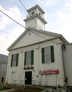
Brooklyn Green Historic District is a historic district on Route 169, Route 205, U.S. Route 6, Wolf Den, Brown, Prince Hill, and Hyde Roads in the town of Brooklyn, Connecticut. The district is notable for its Greek Revival, Colonial, and Federal architecture. It was added to the National Register of Historic Places in 1982.

The Chaplin Historic District in Chaplin, Connecticut is a historic district that was listed on the National Register of Historic Places (NRHP) in 1978. The district encompasses the historic village center of Chaplin, which extends for 0.8 miles (1.3 km) along Chaplin Street, and was most heavily developed in the early 19th century. The focal center of the district is the 1812-15 Congregational Church, which stands on a knoll overlooking the street. Most of the district's buildings are wood-frame houses, although the Witter House is a notable brick structure. Stylistically most of the houses are either Federal or Greek Revival in style. In addition to the church, other public buildings include the 1840 former town hall, the 1911 Colonial Revival Ross Memorial Library building, and Eaton's Store, built in 1850.

The Clinton Village Historic District encompasses the historic portion of the town center of Clinton, Connecticut. It is roughly linear and extends along East Main Street from the Indian River in the west to Old Post Road in the east. The area represents a well-preserved mid-19th century town center, with architecture dating from the late 17th to mid-20th centuries. The district was listed on the National Register of Historic Places in 1994.

The Hamilton Historic District encompasses the early historic center of Hamilton, Massachusetts. It includes properties at 540-700 and 563-641 Bay Road, extending along the road from Orchard Road in the south to Cutler Road in the north. Numerous Greek Revival buildings are located within the district including the First Congregational Church of Hamilton, built in 1843. The district was added to the National Register of Historic Places in 1973.

Goshen Historic District is a historic district encompassing the town center village of Goshen, Connecticut. Centered at the junction of Connecticut Routes 4 and 63, the village developed historically as a rural crossroads of two turnpikes, and has retained its rural character. It is dominated by residential architecture from the first half of the 19th century, and includes churches, a store, and the town's former 1895 town hall. It was listed on the National Register of Historic Places in 1982.

The Main Street Historic District encompasses the historic civic, commercial, and residential center of Durham, Connecticut. The district is primarily linear and runs along Main Street from between Higganum Road and Town House Road in the south to Talcott Lane in the north, and along Maple Avenue, which parallels Main Street. The district includes most of its colonial architecture, as well as many of its civic buildings. It was listed on the National Register of Historic Places in 1986.

Norwichtown is a historic neighborhood in the city of Norwich, Connecticut. It is generally the area immediately north of the Yantic River between I-395 and Route 169.
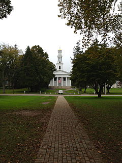
Madison Green is the town green of the New England town of Madison, Connecticut. The green is the centerpiece of the Madison Green Historic District, and is located just west of the commercial strip of Madison on United States Route 1. The green is bounded on the south by US 1, Meeting House Lane on the east and north, and Copse Road on the west. Surrounding the green are several buildings, most prominent being the First Congregational Church. Other buildings around the green include Memorial Hall (1896), a community meeting building, Academy Elementary School (1884), and Lee Academy (1821), as well as many historic houses.
The Capt. John Clark House is a historic house on the east side of Connecticut Route 169, south of Canterbury, Connecticut. This c, 1800 enlargement of an older house is a finely crafted example of a locally distinctive style known as the "Canterbury style". The house was added to the National Register of Historic Places in 1970.

The Woodbridge Green Historic District is a historic district encompassing the historic town center of Woodbridge, Connecticut. It is located in the block bounded on the south by Center Road, on the east by Newton Road, and on the north and west by Meetinghouse Lane. The center is a good example of early 20th-century town planning, with good examples of Colonial and Classical Revival architecture. The district was added to the National Register of Historic Places in 2003.

The New Preston Hill Historic District encompasses a small rural 19th-century village center in the New Preston area of the town of Washington, in Litchfield County, Connecticut. Settled in the late 18th century, it is distinctive for its examples of stone architecture, include a rare Federal period stone church. The district, located at the junction of New Preston Road with Gunn Hill and Findlay Roads, was listed on the National Register of Historic Places in 1985.
The Canton Center Historic District encompasses the historic rural town center of Canton, Connecticut. Extending mainly along Connecticut Route 179, near the geographic town center, is a well-preserved example of a rural agricultural center in Connecticut, a role served until about 1920. The district includes many examples of Late Victorian and Greek Revival architecture. It was listed on the National Register of Historic Places in 1997.
The Somers Historic District encompasses the historic civic and social center of the town of Somers, Connecticut. It stretches along Main Street, with extensions along Springfield Road and Battle Street, and includes a significant number of vernacular Federal and Greek Revival houses. It includes the town's early churches, as well as important civic buildings, including the town hall and library. The district was listed on the National Register of Historic Places in 1982.

The Glastonbury Historic District encompasses a streetscape dating to the 17th century, along Main St. from Hebron Ave. to Talcott Rd. in Glastonbury, Connecticut. In addition to a significant number of 17th and 18th-century houses, it shows the architectural development of the town over time, with buildings spanning three centuries in construction dates. It was listed on the National Register of Historic Places in 1984.

The Town Center Historic District encompasses the historic village center of South Hampton, New Hampshire. Centered around the Barnard Green, the town common, on New Hampshire Route 107A, it includes architectural reminders of the town's growth and change over time. The district was listed on the National Register of Historic Places in 1983.

Roxbury Center is the central village of Roxbury, Connecticut. Centered at the junction of Connecticut Routes 67 and 317, it has been the center of town civic life since the mid-18th century. The village was listed on the National Register of Historic Places in 1983.
The Putney Village Historic District encompasses most of the main village and town center of Putney, Vermont. Settled in the 1760s, the village saw its major growth in the late 18th and early 19th century, and includes a cohesive collection with Federal and Greek Revival buildings, with a more modest number of important later additions, including the Italianate town hall. The district was listed on the National Register of Historic Places in 1986.

The Palisado Avenue Historic District encompasses a predominantly residential streetscape in northeastern Windsor, Connecticut. Extending along Palisado Avenue between the Farmington River and Bissell Ferry Road, it is a basically 18th-century street view, populated mainly with houses from the 18th to the 20th centuries. The district was listed on the National Register of Historic Places in 1987.


